Sydenham Hill to Dulwich Village Short Walk
Dulwich Wood, Sydenham Hill Wood, Horniman Gardens, Dulwich Park and village, Belair Park
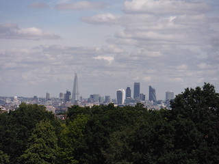
City of London and the Shard, from Horniman Park
SWC Short Walk 9 - Sydenham Hill to Dulwich Village
Jul-16 • thomasgrabow on Flickr
swcwalks short9 banner walkicon 28193423376
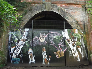
Boarded up Entrance of Railway Tunnel
SWC Short Walk 9 - Sydenham Hill to Dulwich Village
Jul-16 • thomasgrabow on Flickr
walkicon swcwalks short9 28123113072
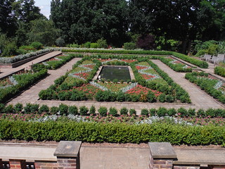
Sunken Garden, Horniman Park
SWC Short Walk 9 - Sydenham Hill to Dulwich Village
Jul-16 • thomasgrabow on Flickr
walkicon swcwalks short9 27611688583
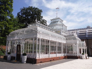
Conservatory, Horniman Museum
SWC Short Walk 9 - Sydenham Hill to Dulwich Village
Jul-16 • thomasgrabow on Flickr
walkicon swcwalks short9 27611709174

Horniman museum, close-up
SWC Short Walk 9 - Sydenham Hill to Dulwich Village
Jul-16 • thomasgrabow on Flickr
walkicon swcwalks short9 27946574760
| Start | Sydenham Hill station |
|---|---|
| Finish | West Dulwich station |
| Length |
6.6 km (up to). |
| Time | 1 hour 30 mins |
| Travel | Trains go from London Victoria to Sydenham Hill and West Dulwich stations. Both are in Travelcard Zone 3. |
| Walk Notes |
This walk takes you through Dulwich Wood, Sydenham Hill Wood, Horniman Gardens and Dulwich Park, finishing in Dulwich Village for refreshments. If you get disorientated in Dulwich Wood or Sydenham Hill Wood, don’t worry too much as wandering around, you will in time come across Cox's Walk footbridge, the car wide metal bridge from which you may resume the directions. |
| Eat |
There are one pub as well as various cafés, bars and restaurants to choose from in Dulwich Village, plus Belair House Bar & Restaurant and Stephanie's café on the way to the station. |
| Profile | |
|---|---|
| Help Us! |
After the walk, please leave a comment, it really helps. Thanks! You can also upload photos to the SWC Group on Flickr (upload your photos) and videos to Youtube. This walk's tags are: |
| By Train |
Out (not a train station) Back (not a train station) |
| By Car |
Start Map Directions Return to the start: Finish Map Directions Travel to the start: |
| Amazon | |
| Help |
National Rail: 03457 48 49 50 • Traveline (bus times): 0871 200 22 33 (12p/min) • TFL (London) : 0343 222 1234 |
| Version |
Nov-24 DAC |
| Copyright | © Saturday Walkers Club. All Rights Reserved. No commercial use. No copying. No derivatives. Free with attribution for one time non-commercial use only. www.walkingclub.org.uk/site/license.shtml |

Walk Directions
- From Sydenham Hill southbound platform, turn left to take the long walkway and steps to reach the College Road exit. Cross over College Road via the zebra crossing and go through the gate opposite, to go up the car wide tarmac track in an easterly direction, (Low Cross Wood Lane - access to pedestrians only).
- In 140 metres up this tarmac track, about 50 metres before it bends right, turn left through a gate in the metal fencing to enter Dulwich Wood. Go gently uphill in a north easterly direction and in 280 metres, where it levels out at a five-way path junction, bear right along the second right minor path (95º initially). Follow this meandering path - ignoring all ways off - for 400 metres (now in Sydenham Hill Wood), to walk up some steps and reach the disused railway track which once carried the Crystal Palace and South London Junction Railway.
- [Worth a detour: the boarded up entrance to the tunnel 100 metres along on the right]
For a slightly higher route, cross the disused railway and in 10m bear left with the fenced path. Curve to the left and then to the right with the path for 70m, gently uphill. In 15m bear left with the path and in 20m pass a ruin on the left (a folly from a Victorian garden) and ignore a right turn. Ignore any paths off for about 300m when you descend down a stepped section to the Cox's Walk footbridge. Turn right and up some steps this side of the bridge.
For the Main Walk Route, turn left along the track, to follow the route of the old railway, 20º. You pass a Dewy Pond on the left and a glade on the right and after 270 metres - where a wooden fence blocks progress and by a bench on the right - turn left to go up some steps and turn right with the fence on your right. In 90 metres walk through a metal kissing gate and turn right over a car wide metal footbridge over the sunken railway track (Cox's Walk Footbridge). Once over the footbridge, veer left up some steps. [If this bridge is still blocked, retrace your steps through the metal kissing gate and along the path back for 90 metres to turn left down some steps back onto the dismantled railway line, turn right along it and in 30 metres turn left, gently uphill, forking left immediately. In 50 metres turn left at a T-junction and in 100 metres descend down a stepped section to the Cox's Walk footbridge. Turn right and up some steps this side of the bridge.] - Where the steps turn right by a bench in front of you, turn left through a metal kissing gate along a path between fences for 100 metres to come out into the grounds of a block of flats. (This was the site of Lordship Lane station.) Turn left to follow the tarmac path past the flats, following Green Chain Walk marker posts and crossing a few tarmac driveways along the way, to come out to Lordship Lane (the A205 South Circular Road) in 200 metres. Turn right to cross Sydenham Hill (road) and then turn left to cross the A205 via the lights at the road junction, to enter Horniman Gardens through its south west entrance.
- Having explored Horniman Gardens and its various delights (Museum and Cafe, Conservatory, Display Garden, Sunken Garden, Medicinal Garden, Sound Garden, Sundial Trail, Succulent Beds, Bandstand, Meadows, Views), exit back through the south west entrance, cross the South Circular Road and turn right to go down it. [The first 350 metres of roadside walking can be avoided by retracing your route into Sydenham Hill Wood to Cox's Walk Footbridge, crossing the bridge and turning right on the other side to go down the broad venue of Cox's Walk to exit onto Dulwich Common (road). This adds 600 metres.] In 350 metres, at the road junction with Dulwich Common (road), and with The Grove Tavern on the opposite side (leased by The Dulwich Estate to Stonegate PubCo until 09/25, who have chosen to keep it closed after a minor fire in 2012), cross Dulwich Common (road) at the lights first (where the Green Chain Walk (Cox's Walk) joins on the left through a metal gate), and turn left to go along the north side of the road. After 350 metres, turn right to go through the Rosebery Gate (south eastern) entrance to Dulwich Park.
- For a recommended route through the park, consult the route map or gpx file, but generally: go in a westerly direction across the park, to emerge at the Old College (western) gate of Dulwich Park, (opposite Dulwich Picture Gallery) onto College Road, and turn right. In 100 metres you pass by a mini roundabout on your left. In the next 200 metres you find The Real Greek and a Pizza Express outlets on the left and a Gail's (bakery), Rocca (Italian restaurant) and the Crown and Greyhound pub on your right, with the Romeo Jones café and Porters Barber & Barista opposite.
- Route to West Dulwich station: Retrace your steps to the mini roundabout and fork right along Gallery Road (passing by Dulwich Picture Gallery on your left-hand side). In 400 metres from the roundabout, just before a zebra crossing and where the 'Lovers Walk' joins from the left, you reach a low wooden gate (the entrance to Belair Park) on your right.
- An amble through Belair Park is recommended (for a suggested route see the route map or gpx file). But the south westerly exit gate close to West Dulwich station shuts an hour before dusk, so you may have to return to this point.
- Otherwise continue along the road, past the recommended tea stop Belair House for a further 250 metres to reach a T-junction with Thurlow Park Road (the South Circular). Turn right for 180 metres to reach Stephanie's café just opposite West Dulwich station on your left-hand side. London bound trains depart from the far platform.