Wanstead Park walk
Parkland of a former country estate
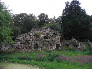
The Grotto
SWC Walk Short 11 - Wanstead Park
Aug-17 • thomasgrabow on Flickr
swcwalks short11 banner 36595546465

Heronry Pond
SWC Walk Short 11 - Wanstead Park
Aug-17 • thomasgrabow on Flickr
swcwalks short11 walkicon 35759927574

The Temple from closer by
SWC Walk Short 11 - Wanstead Park
Aug-17 • thomasgrabow on Flickr
swcwalks short11 walkicon 36549196096
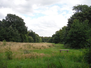
Bench with Long Vista towards Ornamental Pond
SWC Walk Short 11 - Wanstead Park
Aug-17 • thomasgrabow on Flickr
swcwalks short11 walkicon 35785863933


| Start | Wanstead underground station. |
|---|---|
| Finish | Wanstead underground station. |
| Length |
6 km. |
| Time | 1 1/2 hours |
| Travel | Wanstead is a station on the Hainault loop of the Central Line in Zone 4. Travel time from Oxford Circus is 27 minutes, and from Liverpool Street 17 minutes. |
| Walk Notes |
Leafy stroll in the Borough of Redbridge through the Grade II* listed historic landscaped parkland of Wanstead Park, once home to the Palladian mansion of Wanstead House, compared at the time to Blenheim Palace. Today only two smaller structures, The Grotto and The Temple, remain (and the House itself stood on what is now a golf course), but nevertheless the present smaller park retains some of the layout of Wanstead House’s grounds, especially its many ponds, and provides a perfect venue for relaxing and escaping the urban sprawl, with its plentiful water features and varied woods. |
| Eat/Drink |
Plenty of options near the station, see text below for details. |
| History |
Wanstead Park was originally the site of a medieval manor house and later a Tudor mansion, once owned by the Earl of Leicester. In 1667, a wealthy merchant, Sir Josiah Child, bought the house and estate. He started to landscape the gardens and his son Richard, later Earl Tylney, continued the work. The old house (Wanstead Hall) was demolished and replaced by a mansion in the Palladian style in 1715, reputedly costing £360,000, and often being compared to Blenheim Palace. The well-known garden designer, Humphry Repton, who later worked on the grounds, called the finished house and gardens "one of the most magnificent places in this country".
The River Roding rises at Molehill Green near Dunmow in Essex. It then flows south through a group of villages known collectively as the Rodings and on to London and forms Barking Creek as it reaches the River Thames. Between Chigwell and Woodford Green the Roding Valley Meadows make up the largest surviving area of traditionally managed river-valley habitat in Essex.
The Temple is situated in the middle of Wanstead Park. It was designed in the 18th century as a feature for the formal gardens of historic Wanstead Park, complete with a classic portico. The building escaped the destruction in 1824 as it served as accommodation for the Estate's Steward. Today, it is used as a southern base for the Epping Forest Keepers and is open to the public as one of the Forest Centres at weekends. The Grotto was built in the 1760s as a garden feature, following romantic trends for wilder gardens. Grottoes were usually purely decorative. The floor of the main chamber was made of coloured pebbles laid out in patterns and the roof and walls were covered with stalactites, sea-shells and coral. However, this particular grotto did have a purpose: directly below the main room was a boathouse, which opened onto the water. The grotto escaped destruction in 1824 when Wanstead House was demolished, but two years after the park was opened to the public in 1882, it was destroyed by an accidental fire. |
| Profile | |
|---|---|
| Help Us! |
After the walk, please leave a comment, it really helps. Thanks! You can also upload photos to the SWC Group on Flickr (upload your photos) and videos to Youtube. This walk's tags are: |
| By Car |
Start E11 2NT Map Directions |
| Amazon | |
| Help |
National Rail: 03457 48 49 50 • Traveline (bus times): 0871 200 22 33 (12p/min) • TFL (London) : 0343 222 1234 |
| Version |
Apr-24 DAC |
| Copyright | © Saturday Walkers Club. All Rights Reserved. No commercial use. No copying. No derivatives. Free with attribution for one time non-commercial use only. www.walkingclub.org.uk/site/license.shtml |

Walk Directions
- Take the left hand exit out of Wanstead station and, with the Green on the opposite side of the road, turn left along The Green (road). In 180 metres you cross over Redbridge Lane West to continue along St. Marys Avenue. In 300 metres at a road junction with St. Mary’s Church opposite, turn left to go along Overton Drive (i.e. not hard left along Langley Drive), passing by St. Mary’s Church and in a further 100 metres Wanstead Golf Club on your right.
- After 180 metres at a T-junction, turn right along Warren Road. In 70 metres ignore a gate into the golf course on the left and in another 40 metres, turn left through some wooden bollards into Wanstead Park, part of the City of London-owned Epping Forest. From here it is suggested that you take a clockwise route around the Park, exiting back through this entrance to retrace your steps back to Wanstead station.
- In more detail:
- Continue ahead down the footpath through a wooded area, 80°. In 130 metres at a footpath T-junction, turn left for 30 metres to then turn left along a footpath with the Ornamental Waters on your right, and a golf course (behind fencing) on your left. After 250 metres you pass by an HV pylon off to your left, and after another 40 metres have the River Roding on your left. The path veers away from the river and in 100 metres you have the pond on your right again.
- In 300 metres, where the path turns left, you have Lincoln Island on your right and in another 250 metres can spot the other side of the pond through the trees on the right. In 150m you get open views across a narrow arm of the pond and in 100m you walk under an HV cable run.
- In 80 metres you turn right with the path, now with the Roding River on your left again and the audible A 406 not far behind. In another 40 metres at a path triangle, turn right with the Ornamental Waters on your right hand side, your direction west, to go back under the HV cable run after 50 metres. In 170 metres turn left with the path and in another 25 metres pass a bench with The Grotto ahead across this narrow arm of the pond. The path turns right in 300 metres and in 120 metres you reach a four-way junction of gravel tracks by a gap in a tree line (with some green painted utility buildings enclosed by green railed fencing 50 metres ahead along a narrow path through a hedge gap).
- Turn right to continue alongside the Ornamental Ponds, 260°. After 100 metres ignore a right turning path to a car wide brick walled footbridge 40 metres off to your right. After a further 90 metres, you pass by a footpath off to your right (which goes along the right side of Perch Pond), to continue in the same direction with Perch Pond on your right hand side.
- Ignore all ways off and in 370 metres you reach a Park entrance opposite Wanstead Park Avenue.
- Turn right along the sand shingle car wide track between Heronry Pond on your left and Perch Pond on your right. After 100 metres you pass by The Kiosk at Wanstead Park on your right hand side (open daily to 18.00 in summer and weekends only to 17.00 in winter). Turn left to go along Heronry Pond. After 250 metres you reach a Park notice board by a gate away on the left, where you turn sharp right, to head back along a broad track lined by trees towards ‘The Temple’.
- [Chalet Wood on your left has some famous bluebell displays in season. Do consider looping through it along the many marked paths.]
- In 200 metres at a T–junction with the car wide sand shingle track, you have a choice:
- For a short out-and-back to the romantically ruined Grotto, turn right around the fence with The Temple on your left. At the corner of the fence in 20 metres turn left with the track and continue in the same direction past The Temple. In 250 metres continue in the same direction where the wide gravel track turns left and in 75 metres reach The Grotto behind a metal bar fence.
- For the onwards route turn left and where the car wide track swings to the right, continue ahead, on a narrow footpath, 340° [The entrance to The Temple is free and 50m off to the right. Opening Times: weekends/bank holidays in winter 10.00-15.00 & summer 12.00-17.00].
- After 70 metres at a T-junction with a car wide shingle track, turn left along it. In 150 metres you pass a bench on the right with fine vistas back along a clearing to the Ornamental Pond and in another 80 metres where a narrower gravel path joins from the right, fork right off the main track (which leads to a Park exit 25 metres away), along a narrow footpath through the wood, north.
- [!] In 130 metres, turn left along an easily missed footpath, 310°, for 70 metres to reach the entrance (where you came in) onto Warren Avenue, to then retrace your steps back to Wanstead underground.
- [Turn right. In 100 metres, turn left up Overton Drive. After 280 metres at a junction with St. Marys Church on your left, turn right along St Marys Avenue, to join The Green (road) after 300 metres, to then reach Wanstead underground after a further 180 metres.]
- For tea options continue past the station to the four-way junction and find Dana del Elche restaurant 50 metres on the left along Cambridge Park; and the following options across the junction within the next 125 metres of High Street: (on the right) The George pub (Wetherspoon), The Barrel boulangerie, Le Marmiton restaurant, Sumo Fresh restaurant, The Bull pub, Café Chicchi, La Bakerie café and Piccolo Ristorante; (and on the left) Filika and Otto restaurants, Café Brunch and Luppolo Pizzeria.