Woodberry Wetlands (Stoke Newington Reservoirs) walk
Finsbury and Clissold Parks, Woodberry Wetlands (two reservoirs), The New River (a canal supplying water to London) and Abney Park (a Magnificent 7 Cemetery)

Reed Beds and New Builds, Woodberry Wetlands
SWC Short Walk 26 - Woodberry Wetlands (Stoke Newington Reservoirs)
Apr-17 • thomasgrabow on Flickr
banner swcwalks short26 walkicon 33515871410

West Reservoir Centre, Stoke Newington
SWC Short Walk 26 - Woodberry Wetlands (Stoke Newington Reservoirs)
Apr-17 • thomasgrabow on Flickr
swcwalks short26 walkicon 33771281061

The Castle Climbing Centre, Green Lanes
SWC Short Walk 26 - Woodberry Wetlands (Stoke Newington Reservoirs)
Apr-17 • thomasgrabow on Flickr
swcwalks short26 walkicon 33771211171

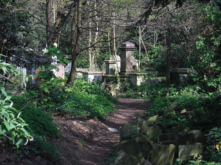
Abney Park Cemetery (III)
SWC Short Walk 26 - Woodberry Wetlands (Stoke Newington Reservoirs)
Apr-17 • thomasgrabow on Flickr
swcwalks short26 walkicon 33515493660

Abney Park Cemetery Funerary Chapel
SWC Short Walk 26 - Woodberry Wetlands (Stoke Newington Reservoirs)
Apr-17 • thomasgrabow on Flickr
swcwalks short26 walkicon 33056921314

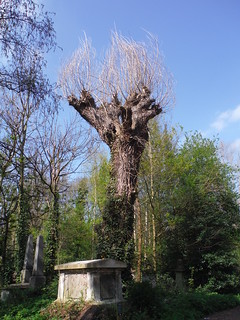
Italian Hybrid Black Poplar in Abney Park Cemetery
SWC Short Walk 26 - Woodberry Wetlands (Stoke Newington Reservoirs)
Apr-17 • thomasgrabow on Flickr
swcwalks short26 walkicon 33900245555

McKenzie Flower Garden, Finsbury Park
SWC Short Walk 26 - Woodberry Wetlands (Stoke Newington Reservoirs)
Apr-17 • thomasgrabow on Flickr
swcwalks short26 33744344542
| Start | Finsbury Park Station |
|---|---|
| Finish | Stoke Newington Overground or Manor House Underground |
| Length | 6.9 km/4.3 mi (Stoke Newington Ending) or 5.0 km/3.1 mi (Manor House Ending) Time: 1 hour 45 mins for the Stoke Newington Ending, 1 hour 15 mins for the Manor House Ending. |
| Travel | Finsbury Park Station is served by Main Line Services from Kings Cross or St. Pancras International, and by the Victoria and Piccadilly Lines. Stoke Newington is served by Overground services from Liverpool Street to Enfield Town or Cheshunt. Manor House is served by the Piccadilly Line. |
| Walk Notes |
Woodberry Wetlands is a Thames Water-owned and London Wildlife Trust-run urban nature reserve on East Reservoir, one of the two Stoke Newington reservoirs on the New River (which – famously – is “neither new nor a river”). The reservoirs were built in 1833 to hold water from the New River, a man-made canal supplying drinking water to London from springs near Ware in Hertfordshire. The reservoir had been off-limits to the public for more than 180 years until 2016, when Woodberry Wetlands and its fantastic café in the former coal house opened. The route starts with a meander through Finsbury Park before entering the Wetlands and then continues along the New River past the West Reservoir to Green Lanes, to then lead south, then east through Clissold Park (and its café in Clissold House) and along the very charming Stoke Newington Church Street to Abney Park cemetery (one of the most splendid and enlightened of the ‘Magnificent Seven’ London garden cemeteries) and from there to Stoke Newington Overground.
Please note:
|
| Eat/Drink |
One Pub and Nine Cafés/Restaurants before getting to Stoke Newington Church Street;
|
| Profile | |
|---|---|
| Help Us! |
After the walk, please leave a comment, it really helps. Thanks! You can also upload photos to the SWC Group on Flickr (upload your photos) and videos to Youtube. This walk's tags are: |
| By Train |
Back (not a train station) |
| By Car |
Start N4 3JU Map Directions Finish N16 6YA Map Directions |
| Amazon | |
| Help |
National Rail: 03457 48 49 50 • Traveline (bus times): 0871 200 22 33 (12p/min) • TFL (London) : 0343 222 1234 |
| Version |
Apr-24 Thomas G |
| Copyright | © Saturday Walkers Club. All Rights Reserved. No commercial use. No copying. No derivatives. Free with attribution for one time non-commercial use only. www.walkingclub.org.uk/site/license.shtml |
Walk Directions
Full directions for this walk are in a PDF file (link above) which you can print, or download on to a Kindle, tablet, or smartphone.
This is just the introduction. This walk's detailed directions are in a PDF available from wwww.walkingclub.org.uk

