Arundel to Goring-by-Sea walk
The River Arun, the Angmering Park Estate and “Worthing's best kept secret” on Highdown Hill.
| Length |
Main Walk: 14½ km† (9.0 miles). Three hours 20 minutes walking time. For the whole excursion including trains, sights and meals, allow at least 9 hours. Extended Walk, with seafront loop: 18¾ km† (11.7 miles). Four hours 20 minutes walking time. Short Walk, starting from Angmering: 11¼ km† (7.0 miles). Two hours 30 minutes walking time. † Add around 1½ km (1 mile; 30 minutes) if visiting Highdown Gardens. See Features below. |
|---|---|
| OS Map |
Explorer OL10 (previously 121). Arundel, map reference TQ024063, is in West Sussex, 5 km N of Littlehampton. |
| Toughness |
3 out of 10 (1 for the Short Walk). |
| Features |
Several SWC walks go through the landscaped Arundel Park to the north-west of the town but the central section of this walk is through the other half of the original Norfolk Estate, Angmering Park. The first 3 km is the same as the Arundel Circular walk (#100) and starts with fine views of Arundel Castle, the principal seat of the Dukes of Norfolk. The massive castle dominates this hilltop town but the ornate Roman Catholic Cathedral and the parish church of St Nicholas also feature prominently on its skyline. After a stretch alongside the River Arun the walk enters the extensive Angmering Park Estate. For the most part this is a mix of commercial woodland and farmland, but there are also stretches along an open valley and on higher ground with a distant sea view. The route then heads south through the village of Patching to a lunch pub on an old main road. The constant roar of traffic on the road's replacement is not far away, and an underpass takes you under the busy A27. After crossing the A280 a gentle climb through woodland eventually brings you out onto Highdown Hill, a stretch of open downland owned by the National Trust with the remains of an Iron Age hill fort on its summit. On a fine day there are far-reaching sea views east to the Seven Sisters and west to the Isle of Wight. The slopes of the South Downs were quarried for chalk and in the early 20thC Sir Frederick and Lady Stern were inspired to create a garden in the unpromising surroundings of an old chalk pit, building up a fine collection of rare plants and trees. Together with a nearby pub and tearoom for refreshment, a visit to “Worthing's best kept secret” (Highdown Gardens, open daily to dusk Apr–Sep, but close around 4pm Oct–Mar; free entry) makes a nice way to put off your descent to the coastal plain and across another busy main road (the A259) to the station. |
| Walk Options |
You could extend the walk by carrying on past the (misleadingly-named) Goring-by-Sea station to the seafront. Directions are included for a simple loop back to the station, but more adventurous souls could use the map to head eastwards for nearly 4 km to finish in Worthing. This coastal stretch is described in the Shoreham-by-Sea to Littlehampton walk (#211) and would make a total walk from Arundel of around 22 km. If you would like to spend more time in Highdown Gardens and/or on the beach, you could start from Angmering station for a more direct route up to Highdown Hill. This Short Walk does involve a fairly long stretch along residential streets, but Angmering village has retained much of its rural charm. |
| Additional Notes |
The original version of this walk took a more southerly route through the Angmering Park Estate, where the Woodman Arms at Hammerpot was nearer the walk's midpoint and so more conveniently placed as a lunch pub. However, this pub closed abruptly in February 2019. The Short Walk route from Angmering was originally included as an alternative ending from Highdown. Anyone wanting to do this ending should find it simple enough to follow from the map. |
| Transport |
Arundel is on the Arun Valley line, with a half-hourly service from London Victoria (hourly on Sundays), taking around 1 hour 25 minutes. Angmering and Goring-by-Sea are adjacent stations on the West Coastway line; they both have a similar level of service and journey time from London plus local services to Brighton. Both lines are operated by Southern and the fare from London to all these stations is the same. The suggested ticket is a return to Littlehampton (which is unquestionably valid at all of them), but in practice a return ticket to any of these stations would almost certainly be accepted at the others. The most convenient option for drivers would be to park at the end of the walk in Goring-by-Sea, although this only has a small station car park costing £4.40 Mon–Fri, £4.30 Sat, £2.30 Sun (2022). Angmering is the next station along but you would need to change trains at Ford or Barnham in order to start from Arundel. |
| Suggested Train |
Take the train nearest to 09:40 from Victoria to Arundel. For the Short Walk you could start half-an-hour later, taking a train from Victoria to Angmering. |
| Train Times |
|
| River Levels |
|
| Lunch |
With the closure of the Woodman Arms the most convenient lunch pub is more than two-thirds of the way through the Main Walk, after 9¾ km. Just south of Patching, The World's End (01903-871346) is a popular Hall & Woodhouse pub with a large beer garden, which serves a good range of food all day from noon. The alternative would be to carry on for a further 3 km to The Highdown (01903-924670), just outside Highdown Gardens. Formerly the Highdown Hotel, it reopened in early 2019 as a Brunning & Price pub after both the hotel and the nearby tearoom closed abruptly in 2018; it has a large garden and also serves a good range of food all day. The Highdown is the suggested place on the Short Walk (after 5¼ km), although you might be tempted to make a very early lunch stop at one of the two attractive pubs in Angmering: The Lamb at Angmering (01903-774300) and The Spotted Cow (01903-783919). |
| Tea |
Outside Highdown Gardens the quirky tearoom which closed in 2018 has reopened as part of The Highdown (see above). The Highdown Tea Room is open daily to 5pm and serves good cakes and cream teas. Allow 20 minutes to reach Goring-by-Sea station from Highdown by the direct route, 25 minutes by the suggested (quieter) route. The seafront loop goes past the large and popular Sea Lane Café (01903-247847) on Marine Drive, which is open year-round to seasonal hours: typically 4-5pm but “longer in fine weather” and as late as 7pm in high summer. The suggested return route also passes a couple of chain pubs, The Mulberry (01903-241555) and the Chef & Brewer Bull Inn (01903-247622). |
| Profile | |
|---|---|
| Help Us! |
After the walk, please leave a comment, it really helps. Thanks! You can also upload photos to the SWC Group on Flickr (upload your photos) and videos to Youtube. This walk's tags are: |
| By Train |
Out (not a train station) Back (not a train station) |
| By Car |
Start BN18 9PH Map Directions Return to the start: Finish BN12 6NT Map Directions Travel to the start: |
| Amazon | |
| Help |
National Rail: 03457 48 49 50 • Traveline (bus times): 0871 200 22 33 (12p/min) • TFL (London) : 0343 222 1234 |
| Version |
Mar-23 Sean |
| Copyright | © Saturday Walkers Club. All Rights Reserved. No commercial use. No copying. No derivatives. Free with attribution for one time non-commercial use only. www.walkingclub.org.uk/site/license.shtml |


Walk Directions
Click the heading below to show/hide the walk route for the selected option(s).


 Walk Map
©
Walk Options
Click on any option to show only the sections making up that route, or the heading above to show all sections.
- Main Walk (14½ km)
Walk Directions
Click on any section heading to switch between detailed directions and an outline, or the heading above to switch all sections.
If you are doing the Short Walk (from Angmering), start at §F.
- Arundel Station to Warningcamp (2 km)
- From the station, turn right onto the signposted pedestrian and cycle route. This goes under the A27 and turns left to join it opposite the station approach road. Keep right at the roundabout to head briefly towards the town centre, then turn right onto a short footpath leading to the river. Turn right again onto the riverside path and follow it away from the town for 1 km. Turn right to cross the railway and go along a lane to a road junction in Warningcamp.
- Arriving from London, cross the footbridge to exit through the main station building and immediately turn right onto the signposted pedestrian and cycle route to the Town Centre. This takes you under the A27 and turns left to head directly towards Arundel Castle?, joining the busy main road opposite the station approach road.
- Keep right at the roundabout, heading towards the town centre. Where the pavement ends after 100m, however, turn right onto a signposted footpath. This soon comes to the River Arun? where you turn right again onto the riverside path, joining the Monarch's Way? (MW).
- Go over a stile and follow the riverside path for 1 km, gradually curving round to the left with a fine view back to the town's skyline. Eventually the path veers right, away from the river and towards the railway line.
- Go through a wooden swing gate and keep ahead towards a large white house on the other side of the railway. Cross the tracks carefully at the level crossing and continue along a tarmac lane for 300m to a road junction in the hamlet of Warningcamp.
- Warningcamp to Angmering Park Cottages (3¼ km)
- Turn left towards Burpham, then take a bridleway on the right along the side of a wooded valley in the Angmering Park Estate, continuing along the valley floor. At the far end go back into woodland and fork right up a slope to a small clearing in Wepham Wood. Go across an estate road and follow a forest track (public footpath) south-east through Lower Wepham Wood for 1 km. At a T-junction turn left onto a bridleway to come to Angmering Park Cottages at Wepham Ball.
- Turn left at the road junction, towards Wepham and Burpham. In 400m turn right into the Angmering Park Estate?, going past a double wooden fieldgate onto a wide bridleway through partly-cleared woodland. In 600m go through another fieldgate and continue on a grassy path through a dry valley, curving gently round to the left alongside a line of small trees.
- Ignore paths off to both sides (leaving the Walk #100 route, which goes up Warningcamp Hill on the left) to continue along the valley floor. Shortly before reaching a hedge across the valley follow a farm track towards a fieldgate in the trees on the right. Go through a wooden side gate and bear left at a bridleway junction to continue just inside the wood.
- The track comes to a T-junction level with the hedge across the valley where you turn right. In 40m fork right at another three-way junction to climb steadily through the wood. Near the top keep ahead at a track crossing to come to a small clearing by an estate road in Wepham Wood. Go straight across the estate road (finally leaving the MW) and continue past a small parking area on a forest track, signposted as a public footpath.
- The track soon curves slightly right to head SE. You now simply follow it in much the same direction for 1 km, eventually going down a slope to a four-way junction. Turn left at this junction onto a bridleway, which in 200m comes to Angmering Park Cottages on the right.
- Angmering Park Cottages to Patching Church (3¼ km)
- At the cottages turn right onto a footpath heading south-east and then east across fields, passing to the south of Angmering Park House. Continue in the same direction on a bridleway through estate woodland to Patching Hill. Turn right onto a footpath going down across a field to Patching church.
- Just past the cottages turn right onto a signposted footpath, up into the woodland. At the top of the slope turn right at a T-junction and follow the path out of the trees. Turn half-left as indicated onto a long straight grassy path between wooden fences, heading SE with views of the sea 6 km away.
-
At the end veer right briefly onto an estate road, away from a security gate. On the other side of a hedge turn left onto the continuation of the footpath, a broad grassy strip on the left-hand edge of a large field, going across a dip in the ground and heading E.
In the dip you can see Angmering Park House? through a gap in the hedge, 450m away.
- At the top of the slope keep ahead at a path crossing, now on a farm track along the field edge. In 350m stay on the field edge where the track turns left into a wood. In the far left-hand corner follow the path into the trees. At a four-way junction keep ahead onto a forest track which swings left up a slope, then curves back to the right.
- Follow this bridleway through the estate woodland for 1 km, going straight ahead at all path crossings; there might be a few muddy patches but these are easily skirted around on side paths. At the far side of the wood leave the Angmering Park Estate and continue on the bridleway between large farm fields, with the spire of Patching church visible down to your right and Highdown Hill in the distance, 2½ km away.
- There is a right of way across the field towards the church, but the turning off the bridleway has not always been clearly indicated. About halfway along the field edge (where a footpath should be signposted) turn right to go down the middle of the field. As there is no way to cut through the churchyard, carry on to a footpath signpost by the buildings of Patching Farm.
- Turn left at this junction onto a lane curving round to the right. This passes between the farm buildings and the parish church of St John the Divine?, which is worth a quick visit.
- Patching Church to Arundel Road (1¼ km)
- Head south briefly on The Street and turn left onto Coldharbour Lane. Turn right onto a footpath going across a field and then along the edge of a meadow. Go past Patching Pond to the pub on Arundel Road.
- At the end of the farm lane turn right onto the road running through the village (The Street). In 100m turn left and go along Coldharbour Lane for 150m, then turn right into a small (no-)parking area in front of some houses. Take a grassy track to the right of these houses and immediately veer left on a short path through the undergrowth into the top of a large farm field.
- Follow a clear path across the field, heading SSE. On the far side go over a stile in the hedge and bear right onto a broad grassy path along the edge of a long meadow, with a hedge on your right; you might be able to glimpse the large Patching Pond through the trees down to your left.
-
In the far right-hand corner continue on a narrow path through a belt of trees. Ahead on your right you will soon be able to see the beer garden of the suggested lunch pub, The World's End?.
- There is a plank bridge over a ditch on the right and an unofficial path through a field to the pub's rear car park. A fieldgate leading directly into the pub's garden is usually locked, but you could go through the car park and round to its back door.
- The simplest route is to carry on along the footpath to the old main road, now a quiet lane. From a gate into the pub's front car park you can go up to its main entrance, or round the side into its beer garden.
- Arundel Road to Highdown Hill (2¼ km)
- Go across Arundel Road onto a lane going under the A27. Turn left and follow a bridleway between this road and the A280. At the top cross the A280 and continue to a bridleway junction. Turn right and follow this south between fields and through Highdown Copse to Highdown Hill, going up to the summit on the right for the best views.
- Go straight across the old main road and around a locked metal gate onto the lane opposite the pub. Follow this down a slope and under the new main road, the busy A27. Shortly before reaching another main road turn left onto a chalky path going gently uphill, with trees and shrubs shielding the two roads from sight (if not sound).
- At the top follow the bridleway round to the right and cross the A280 with great care onto its continuation opposite, which curves round to the left. At the end turn right briefly onto an unsurfaced lane, but where this swings left keep ahead past a metal fieldgate onto a stony track between hedges. Follow this bridleway steadily uphill for 1 km, at first between fields and then through Highdown Copse.
- At the end of the wood fork left in front of a National Trust sign for Highdown Hill? to emerge onto open downland. Bear right and go alongside a hedge for 75m to a four-way signpost. The walk route continues down the slope to the left, but it is worth going up the slope on the right for the views from the Iron Age hill fort? on its summit.
- Angmering Station to Angmering (village) (1¾ km)
- Turn right onto Station Road, heading north. Shortly after crossing the busy A259 on a footbridge switch to a quieter parallel road (North Drive) on the left, returning to Station Road at the far end. Fork left at Angmering's village green, then turn right onto Church Lane to return to the main road in the centre of the village.
-
From either platform go out onto Station Road by the level crossing and turn right to head N, going over the tracks if exiting from Platform 2. Stay on the right-hand side of this road and go up to the roundabout with the busy A259, where the onward route is along Station Road on the other side.
There is a designated crossing point for cyclists just off to the right, but at most times it will be easier to use the pedestrian footbridge.
-
Station Road goes all the way into Angmering village, but after 300m it is more pleasant to switch to a parallel residential street on the left (North Drive). This goes between bungalows and a belt of mature trees which help to reduce the traffic noise from the main road.
A narrow path through the trees looks tempting, but it soon peters out and is not worth the effort.
- In 700m the two roads merge and a further 150m along Station Road brings you to the small village green. Instead of simply continuing along the main road, the suggested route is to fork left in front of the green onto Arundel Road.
- Opposite the parish church of St Margaret? turn right onto a narrow street of attractive cottages (Church Lane). Follow this back to the main road, coming out by The Lamb at Angmering.
- Angmering to Highdown Hill (2¾ km)
- Cross the main road onto the B2225 (High Street), heading east. Where this turns right keep ahead on a bridleway, crossing the A280 on a footbridge. Veer right and left to continue eastwards along the brideway. Turn left onto a footpath going past a converted windmill and follow it round to the right to reach the National Trust land at Highdown Hill. Go up to the hill fort on the summit.
- In front of the pub cross the main road carefully onto the start of Angmering's High Street, going up a short rise and curving round to the left to head E. In 500m keep ahead on a minor road where the main road turns right, soon passing The Spotted Cow on the left.
- You could continue along this lane to a tricky crossing of the A280, but after passing the entrance to the pub's car park it is better to veer left onto a bridleway which curves round to the right and crosses it on a footbridge. On the other side keep ahead at a junction of paths onto a tarmac driveway, the continuation of the bridleway. This veers left away from the main road, heading E again.
- Ignore a footpath off to the right and stay on the drive as it jinks left and right, climbing gently. After passing the entrance to a couple of properties the bridleway becomes a chalky track. In a further 125m turn left onto a narrow footpath, climbing steadily between hedges and soon with a view of the sailless Ecclesden Mill? off to the left.
- Follow the path round to the right as indicated, soon with a fence on the left. Follow this broad farm track as it swerves right and left, still climbing steadily and eventually going through a kissing gate onto Highdown Hill?, with a National Trust sign. Keep ahead on a grassy path to …
- Highdown Hill to The Highdown (pub) (¾ km)
-
 Take a grassy path heading south-east down the hillside to the upper car park for Highdown Gardens and the nearby refreshment places.
- From the hill fort go down the hillside to the left, retracing your steps past the four-way signpost if you were on the Main Walk. Take the right-hand of two broad mown paths towards the belt of trees ahead, where there is a National Trust information panel about Highdown Hill. Go through a wooden swing gate in a low flint wall (marking a Borough boundary); on the other side the Miller's Tomb? is on the left, surrounded by iron railings.
-
Carry on downhill in much the same direction, following the main path past more clumps of trees and round to the right. Go past a picnic area and through a gate into the upper car park for Highdown Gardens, next to their entrance.
- The Highdown? pub and its Tea Room are outside the gardens, so carry on down the road if you want some refreshment before visiting them.
-
Notes on visiting Highdown Gardens (~1½ km)
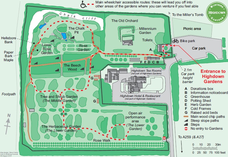
- This Worthing Borough Council map shows the main areas within these steeply-sloping gardens. There is only one access point, so you will be coming back out the same way.
- Leaflets showing suggested trails through the gardens can be obtained from a new Visitor Centre in the Upper Garden.
-
There is free entry to the gardens, with a Donations box on the entrance path just before the Visitor Centre.
- The Highdown to Goring-by-Sea Station (1¾ • 1½ km)
-
Go briefly down the long straight driveway towards the A259, but at the corner of the gardens go through a gap in the trees into a meadow at the top of a recreation ground.
- For the main route go diagonally across this open space, through the belt of trees to a bridleway and out to the main road. Cross over and go along Ferring Lane opposite for 200m. Take a footpath on the left towards the railway line and turn left at the end to reach the station.
- For a slightly shorter (but noisier) route, keep left in the meadow and return to the driveway via the lower car park. Cross the main road and turn left onto the footway on the far side. Turn right at the roundabout, then in 250m bear right onto a tarmac path and continue on Goring Street to the station.
- Go out onto the main driveway and start to head downhill towards the A259. As you pass a locked gate at the bottom corner of the gardens bear right onto a short path through a belt of trees. This leads into the corner of a meadow at the top of a recreation ground.
-
Main route (1¾ km)
-
Go diagonally across the meadow and down the right-hand side of the recreation ground. Just before the bottom corner veer right onto a narrow path through the belt of trees, which leads to a tarmac driveway. Turn left and pass to the left of a vehicle barrier to come out onto the main road.
Despite appearances this driveway is a right of way, grudgingly acknowledged with a small ‘Pedestrian access’ sign on the gatepost and a bridleway signpost by the road.
- Turn right briefly onto the footway and cross the busy dual carriageway with great care at the designated crossing point. Continue along the residential street opposite (Ferring Lane) for 200m.
- Where the road swings right turn left onto a signposted footpath between houses #38 and #40. Follow the narrow and potentially overgrown path out to a hedge boundary between two fields.
-
Bear right to go along the field edge, with the hedge on your left. At the end turn left onto a footpath alongside a chainlink fence, parallel to the railway line. In 600m this comes out onto Goring Street, with the station opposite.
- If you are not doing the seafront loop, Platform 1 on the near side is for trains to London and Brighton.
-
Direct route (1½ km)
- Go down the left-hand side of the meadow and return to the driveway through the lower car park (there is no exit in the bottom corner). At the end of the drive cross the busy dual carriageway with great care at the designated crossing point and turn left onto the footway on the far side.
-
At the roundabout follow the footway round to the right, still alongside the A259. In 250m (just before traffic lights) bear right off the main road onto a tarmac path, which leads into Goring Street. Go along this quiet street (the old main road) to a level crossing, with the station on the left.
- …
- Goring-by-Sea Station to the Sea Lane Café (2¼ km)
-
Go over the level crossing to head south on Goring Street, crossing over Goring Way. Veer right past the Bull Inn and cross Fernhurst Drive onto the short Bodiam Avenue. At the entrance to Goring Hall Hospital turn right briefly onto a bridleway, then turn left into Fernhurst Recreation Ground. Go along its left-hand side and diagonally across the playing field beyond it. Join a broad path in a plantation of trees and follow it all the way to the seafront. Turn left and go along a footpath for 600m to the Sea Lane Café.
-
 If you want to extend the walk to Worthing (an extra 5 km), carry on along the seafront, heading east.
Turn left onto one of the streets off Marine Parade near Worthing Pier, 3¾ km away.
If you want to extend the walk to Worthing (an extra 5 km), carry on along the seafront, heading east.
Turn left onto one of the streets off Marine Parade near Worthing Pier, 3¾ km away.
-
- Go over the level crossing to head S on Goring Street. In 250m bear right in front of a T-junction and cross over Goring Way to continue on another part of Goring Street. After passing a playing field and the Bull Inn turn right briefly onto Fernhurst Drive, then left into Bodiam Avenue.
- At the end of this short street turn right in front of the entrance to Goring Hall Hospital. Go along a tree-lined bridleway (part of the striking Ilex Avenue?, also on the return route) for 40m and then veer left through a gate into Fernhurst Recreation Ground. Go along its left-hand side, through a gap in the corner and diagonally across a second playing field.
- In the far corner go through a gap in the trees and turn right onto a broad path through The Plantation?. Follow this path for 500m to the seafront, crossing two minor roads along the way. At the end turn left and go along a raised footpath (or the shingle beach) for 600m to reach the Sea Lane Café.
-
Finishing at Worthing Station (+5 km)
-
Carry on along the seafront, heading E. The station is 1¼ km inland.
…
- The Sea Lane Café to Goring-by-Sea Station (2 km)
- Go all the way up Sea Lane and turn left onto a bridleway between two residential streets (Ilex Way). Cross over Aldsworth Avenue and fork right onto a short path through the trees to Fernhurst Drive and the Bull Inn. Retrace your outward route along the two sections of Goring Street to the station.
-
Go across the roundabout behind the café and head N on Sea Lane. At the roundabout at the far end of this long avenue, with The Mulberry pub on the right, turn left into Ilex Way. Go along the broad tree-lined bridleway in the middle of this residential street for 400m to Aldsworth Avenue.
Just over halfway along there is an information panel in the trees on the left about the history and wildlife of Ilex Avenue, encountered briefly on the outward route.
- A simple route back to the station would be to turn right onto Aldsworth Avenue, eventually passing a parade of shops (including a restaurant and some fast-food shops); then turn left at the A259 roundabout into Goring Way and immediately right into Goring Street.
- The suggested route (along quieter streets) is to go straight across Aldsworth Avenue onto the continuation of Ilex Avenue, but almost immediately fork right onto one of the narrow paths used by dog-walkers to cut through the trees to Fernhurst Drive, 100m away. Head towards the Bull Inn (visible off to your left) and retrace your outward route along Goring Street.
- On the other side of Goring Way the continuation of Goring Street leads to the station. If the level crossing is down, cross the footbridge to Platform 1 for trains to London and Brighton.
- Arundel Castle was founded in the 11thC but most of the original Norman castle was left in ruins after being besieged twice in the English Civil War. The author Mervyn Peake lived nearby in Burpham and the restored building was presumably one of the inspirations for the imposing castle at the centre of his Gothic trilogy Gormenghast.
- The River Arun is one of the fastest-flowing rivers in England and is tidal on this stretch. It was first embanked in the 16thC and a canal linking it to the River Wey briefly provided a trading link between London and the South Coast in the 19thC before being superseded by the railway.
- The Monarch's Way is supposedly the escape route taken by the future King Charles Ⅱ after his defeat by Parliamentary troops at the Battle of Worcester in 1651. It is the longest inland trail in England, running for 990 km from the battlefield to Shoreham-by-Sea.
- The Angmering Park Estate is a large private estate managed for forestry, farming and shooting, with a Stud and Racing Stables at its centre. It was the eastern half of the original Norfolk Estate.
- Angmering Park House was built in 1982, replacing an older farmstead to the west.
- St John the Divine, Patching was built as a chapel in the early 13thC and became a parish church in 1282. It was heavily restored in the 19thC and re-dedicated to St John since the original dedication had been lost. It contains copies of two famous paintings by Rubens and Murillo.
- Originally the Horse and Groom, The World's End acquired its present name in 2002 “in homage to the seafarers of the past who feared sailing off the edge of the world” (although the pub sign offers a different interpretation).
- Highdown Hill (81m) is the only hill on the Sussex coastal plain. Unlike other hills on the South Downs, it has a gentle ‘dip’ slope on its north face and a steeper ‘scarp’ slope facing the sea.
- The small Iron Age hill fort on the summit of Highdown Hill dates from around 600 BC and consists of a single rampart and ditch. There was also an Anglo-Saxon cemetery on the site.
- St Margaret, Angmering dates from the 13thC, with its tower being added in 1507.
- Ecclesden Mill (or Highdown New Mill) was a brick tower-mill built in 1826, taking over from John Olliver's Highdown Mill. It ceased working in 1872 and lost its sails in a storm in 1880. It was converted into a house in the 1970s and has since been further restored, with a lead cap added.
- The Goring Gap (whimsically named after the more famous feature on the Thames) is one of several gaps between settlements in West Sussex, a planning policy by the local authority to prevent a continuous sprawl of development along the coastline.
- The Rampion Wind Farm was developed by E.ON and completed in 2018. It consists of 116 turbines with a combined capacity of 400 MW, covering an area of 72 km² between 13 and 25 km offshore.
- The Miller's Tomb was built by John Olliver 27 years before his death in 1793. An eccentric character who was outwardly a prosperous miller, Olliver was rumoured to be the leader of a local smuggling gang, using the tomb to store contraband.
- The Highdown was previously the Stern's home, Highdown Towers. The mansion and gardens were bequeathed to the Borough of Worthing after Lady Stern's death in 1972. Since then it has been a multi-room nightclub (Sterns), the Highdown Hotel and is now a pub.
- Ilex Avenue was created in the 1840s as a grand carriage drive from Ferring in the west and Goring in the east to Goring Hall (now a private hospital). It is 1¼ km long and was planted with over 400 holm oaks (Quercus ilex), an evergreen oak from the Mediterranean which tolerates salt-laden winds.
- The Plantation is a broad avenue of trees running inland from the beach, planted to connect with Ilex Avenue. It marks the eastern boundary of the Goring Gap.
The start is the same as Walk #100.
Continue the directions at §H.
There are far-reaching views from the summit: on a fine day you can see the coast from the Seven Sisters to the Isle of Wight. The small undeveloped chunk of coastline ahead is known as the Goring Gap?, and far out to sea you might be able to glimpse the huge Rampion Wind Farm?.
There are no other refreshment places on the direct route to Goring-by-Sea station, but the seafront extension (included on the Short Walk) goes past a café and two pubs.
There are two possible routes to the station, but the direct route in [?] suffers badly from traffic noise and is only recommended if you are in a hurry to catch a train.
If you want to extend the walk to Worthing instead of returning to Goring-by-Sea station, follow the outline directions below.
Walk Notes
» Last updated: March 14, 2023
Return to Top | Walk Map | Walk Options | Walk Directions.