Ash Vale to Worplesdon walk
The Basingstoke Canal, Ash Ranges (Remote, hilly MOD land with unrestricted access), Cobbett Hill and Whitmoor Common.

Walk under the pines near Pirbright
Oct-23 • stephenmid on Flickr
swcwalks swcwalk136 banner 53262106483
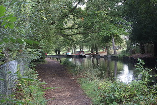
Narrow Boats on the side of the canal - Ash Vale
Oct-23 • stephenmid on Flickr
swcwalks swcwalk136 walkicon 53262119598

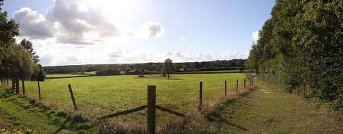
Walking by the army base near Pirbright
Oct-23 • stephenmid on Flickr
swcwalks swcwalk136 walkicon 53260942402
A place for a pause near Merrist Wood College
Oct-23 • stephenmid on Flickr
swcwalks swcwalk136 walkicon 53262161244
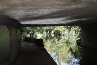
Taking canal under the bridge - Ash Vale
Oct-23 • stephenmid on Flickr
swcwalks swcwalk136 53262176144
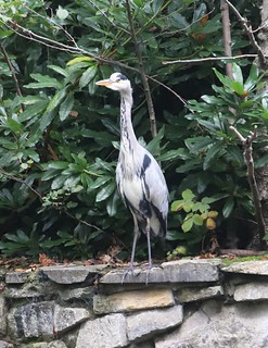
Grey Heron on the canal bank - Ash Vale
Ardea cinerea
Oct-23 • stephenmid on Flickr
swcwalks swcwalk136 bird 53260931422
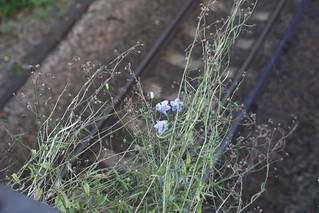
Flax on a railway bridge - Ash Vale
Linum usitatissimum
Oct-23 • stephenmid on Flickr
swcwalks swcwalk136 53262118883
| Length |
19.8 kilometres |
|---|---|
| OS Maps |
Explorer map 145. Ash Vale, map reference SU892533, is in Surrey, 10 km West of Guildford. Worplesdon, map reference SU102439, is also in Surrey, 4 km South of Woking. |
| Toughness |
4 out of 10. |
| Features |
The walk begins with an easy stretch along the Basingstoke Canal before undulating across the Ash Ranges to the North East. Note that this is MOD land, there are few footpath signs and navigation can be difficult, but there are no access restrictions. A second, more remote, stretch of canal is followed by a section of woodland between isolated farms, now heading predominately South East. The going can be heavy underfoot in places. After a late-ish lunch at The Royal Oak near Pirbright (Stanford Common) you head East across Cobbett Hill to Merrist Wood College and the A322 at Worplesdon village. Finally you cut across Whitmoor Common to Worplesdon station. |
| Shortening the Walk |
The main walk could be shortened by cutting across the restricted area of the Ash Ranges from Point 1 to Point 4, but this is subject to access. If the firing ranges are open, alternative endings at Brookwood, Ash, Ash Vale or Wanborough stations are suggested. It would be possible to end the walk at Brookwood. The easiest route would be to stay on the canal towpath after section 2. For a longer walk, you could leave the main route at Point 3 and follow the directions in Walk 107 (Ash to Brookwood) from Point 2, via Pirbright and Brookwood Cemetery. This would make for a walk of 18.2 kms, with lunch in Pirbright after 11.3 kms and several options to further shorten the walk. You could reduce the distance to 16.5 kms by leaving the main walk earlier at Point 2 and continuing straight ahead along the unmade road (West Heath) for 200 metres after Shepherd’s Well. At the T-junction, turn left in to Church Lane. After 150 metres, you reach Point 3 of Walk 107 and follow the directions for that walk, initially continuing along the road. If you are walking on a Sunday, when there are no trains to Worplesdon, you will need to end the walk in Worplesdon village, by either omitting the final section or if you have time and a map, continuing on the main route as far as Jordan Hill. Directions for returning to Worplesdon village via Goose Rye Road and Rickford Common are given at the end of the main directions. From the A322 you can get a 91 bus (see below). There are several bus options which may help if you want to abort the walk at lunch or to walk on a Sunday, when there are no trains to Worplesdon. Unlike the trains, the buses also run to Frimley and Camberley. Dicksons Travel 48 runs on Monday to Friday only, between Woking, Brookwood and Frimley. Turn left on Gole Road at the end of section 2 of the walk and you can board the bus at Gole Road Cottages, Brookwood. According to Traveline, services for Woking stop here 11 minutes after Frimley Green and 2 minutes before Brookwood station. It is normally easier to walk to Brookwood by the canal and get the train from there. Arriva 28 runs on Monday to Saturday between Woking, Brookwood, Pirbright, Worplesdon and Guildford. It goes via Stanford Common; this is not a timetabled stop but (according to Traveline) services to Woking stop there 4 minutes after leaving Worplesdon and services to Guildford stop 3 minutes after leaving Pirbright. The bus stops are on Ash Road; directly ahead of you as you turn off the road just after lunch. Note that the bus goes to Worplesdon village but not to the station, so you would need to omit the final section of the walk. Arriva 91 runs on a Sunday on the same route as the 28 but does not go via Stanford Common. The last bus from Worplesdon Post Office is at 4.18 to Woking and at 4.36 to Guildford. There is also a bus stop opposite the White Lyon. Arriva 35 runs on Monday to Saturday from Camberley via Guildford to Woking on the A320. The nearest stop to Worplesdon station is at Maybourne Rise, Mayford. |
| Travel |
Take the train nearest to 9.15 from Waterloo to Ash Vale. Sit on the left for views of Brookwood Cemetery and the Ash Ranges. South West Trains run direct from Waterloo to Alton via Ash Vale, every half hour on Monday to Saturday and every hour on Sunday (journey time 51 minutes), and also every half hour on Monday to Saturday and every hour on Sunday between Guildford and Ascot via Aldershot and Ash Vale. South West Trains serve Worplesdon station by fast trains from Waterloo to Portsmouth via Woking and Guildford (journey time 32 minutes). There is only one train an hour outside the rush hour, departing for Waterloo at 40 minutes past the hour until the early evening. There is no service on Sundays. Buy a return to Ash Vale and a single from Worplesdon to Woking at the end of the walk. |
| Points of interest |
Old Guildford Road Before the Army acquired the Ash Ranges in the mid-nineteenth century, this was the main road from Frimley to Guildford. The middle stretch of the road is now within the restricted area and follows the course of the short cut to Worplesdon. From the Frimley end the old road still exists and serves a number of houses but at Point 1 and beyond it is a muddy and potholed BOAT (Byway Open to All Traffic). Basingstoke Canal The canal was built in the late 18th century, to carry agricultural cargoes to the capital. A proposed route northwards to the River Thames proved too costly, so the present route was surveyed by William Jessop and opened in 1794. Traffic proved to be lighter than expected and ambitious plans for extensions to Southampton and Bristol were dropped. Trade picked up during the 1830s, carrying construction materials for the London & Southampton Railway, but in the longer term the railway competition made things worse and by 1866 the company was bankrupt. The business soldiered on under a succession of different owners, but Greywell tunnel (6 miles east of Basingstoke) collapsed in 1932 and it is hard to imagine that the canal will ever return to Basingstoke. By the mid-1960s the canal had become little more than an overgrown marsh, and the Surrey & Hampshire Canal Society began a campaign for public ownership and restoration as a leisure amenity. In 1991 the canal was re-opened from West Byfleet (where it connects to the River Wey) to the Greywell Tunnel, which is visited on SWC walk 84 from Hook to Winchfield. Fox Way A 39 mile circular walk linking Clandon, Godalming, Wanborough and Worplesdon stations, marked on the ground and on the OS map. Named after its creator, Richard Fox, not after the local wildlife. Merrist Wood College This college specialises in the ‘land based industries’; the indoor riding arena is one of the largest of any college in the country and a pre-Olympic training venue for the London 2012 Olympic Games. The College is also the home of the Chelsea Football Academy. A large, diverse animal management centre has both domestic and exotic animals. Other facilities include specially designed studios and workshops for floristry, garden design, horticulture and landscaping. This church, positioned prominently above Worplesdon village. dates from the 13th century with its chancel, north chapel, nave and aisles surviving from this period. The tower dates from the mid-15th century and is said to be the best of its period in Surrey. The church has fine manorial stained glass, including two 14th Century figures. The 17th Century font, altar rails and pulpit were a gift from Eton College. A semaphore tower once stood in the churchyard. Restoration was undertaken in 1866 and the south chapel added ten years later. Whitmoor Common Whitmoor Common is owned by Surrey County Council, managed by Surrey Wildlife Trust and has been designated a Local Nature Reserve, a Site of Special Scientific Interest and a Specially Protected Area. The common is mostly recovering heathland, but this walk goes through mature woodland and passes a pond near the centre. The woodland areas are managed to create a range of habitats to suit a variety of plants and animals, including water voles, adders and grass snakes, dragonflies and birds such as Dartford warblers, stonechats, woodlarks and nightjars. In June the open heaths have silver-studded blue butterflies - one of the few places they are found in the UK. The woods are good for white admirals and silver-washed fritillaries (also butterflies) in late June and early July. For more information on the heathland and the marked trails: http://www.surreywildlifetrust.org/files/whitmoorsgtleaflet.pdf |
| Lunch |
The Basingstoke Canal Visitors Centre at Mytchett is more of a late breakfast option, reached after 2 kms. It has toilets and a tea room serving hot and cold food. In summer it opens from 10.30 to 4.45 every day except Mondays. Winter opening is reduced and it does not open at weekends, or any day in December. If the Visitors Centre is closed you could cross the road to Potter’s Family Restaurant , which serves cheap and cheerful food from 11am to 11pm. Royal Oak , Aldershot Road, Pirbright is the recommended lunch stop for the main walk, reached after 11.6 kms at Stanford Common. Tel: 01483 232466. A village pub (though actually some way from Pirbright) with garden, serving a wide range of food from 12 every day. Two main courses for £10. |
| Tea |
The Courtyard Snack Bar at Merrist Wood (14.9 kms in to the walk) offers light refreshments. Open from 8.30am to 4pm but probably only on weekdays in term time. The Café Bar on campus is open until 10.30pm. In 2023 there were no refreshment options in Worplesdon itself. Jolly Farmer , Burdenshott Road, Whitmoor Common, Worplesdon. Tel: 01483 234658. 17.5 kms in to the walk (including a detour of 0.5 kms – see route directions). The restaurant is open until 9.30 on Saturdays. ‘This pretty village pub is set in a beautiful countryside location. In the heart of some of the most stunning National Trust territory, it is a popular retreat for walkers, ramblers and people who just like being outdoors. Inside, the real fires and low beams create a cosy and intimate atmosphere. Outside there is a lovely garden with a covered seating area.’ Worplesdon station coffee shop opens in the weekday morning rush hour only. |
| Profile | |
|---|---|
| Help Us! |
After the walk, please leave a comment, it really helps. Thanks! You can also upload photos to the SWC Group on Flickr (upload your photos) and videos to Youtube. This walk's tags are: |
| By Train |
Out (not a train station) Back (not a train station) |
| By Car |
Start GU12 5LP Map Directions Return to the start: Finish GU22 0RN Map Directions Travel to the start: |
| Amazon | |
| Help |
National Rail: 03457 48 49 50 • Traveline (bus times): 0871 200 22 33 (12p/min) • TFL (London) : 0343 222 1234 |
| Version |
Nov-23 Mike Powell |
| Copyright | © Saturday Walkers Club. All Rights Reserved. No commercial use. No copying. No derivatives. Free with attribution for one time non-commercial use only. www.walkingclub.org.uk/site/license.shtml |

Walk Directions
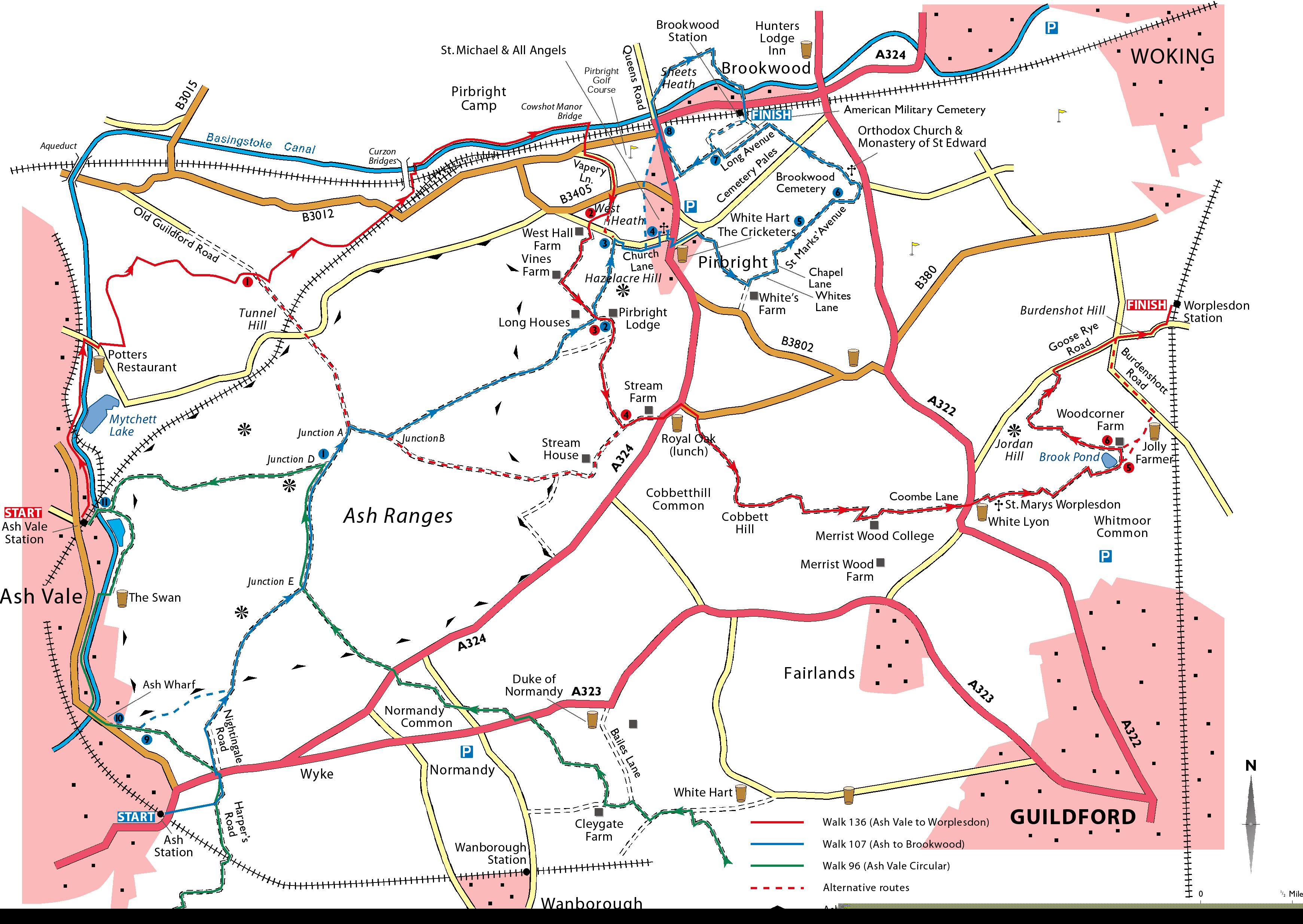
1) Ash Vale to Old Guildford Road (4.0 kms)
- Trains from Waterloo arrive at Ash Vale station on platform 2. Descend two flights of steps, turn left and make for the top of the parking area. After 80 metres drop to the right of the combined rail and foot bridge and turn left (North) on the Basingstoke Canal towpath, with the canal to your right. In 750 metres you go under a closed wooden footbridge, then in another 150 metres you pass under a rail bridge, with Mytchett Lake to the right of the canal. In 180 metres you pass under a road bridge (Mytchett Lake Canal Bridge) and in 650 metres you reach another road bridge (Mytchett Place Bridge). Go up the wooden steps after the bridge and in 20 metres take the road bridge over the canal. However if you wish to make use of the café or toilet facilities at the Basingstoke Canal Visitors Centre, stay on the towpath to the next footbridge and make your way through the Visitors Centre to Mytchett Place Road.
- Ignore a drive on your left in 100 metres (signposted to the Basingstoke Canal Visitors Centre). Take the unmarked bridleway to your left in 60 metres (just after the entrance to Potter’s Restaurant on the opposite side of the road), with a wire fence on your left and a wooden fence on your right. The bridleway turns right (East) to go through a barrier surrounded by yellow warning signs after 50 metres (ignore the path to the left just after the barrier), then climbs gradually. After 200 metres, turn sharp left on a clear but unmarked public bridleway, through pine-covered heathland.
- (!) In 400 metres you maintain the same direction (350°) on a narrow path at an unmarked junction, where the main path branches half right and there is also a path to the right. In 120 metres you come to a fence with sports fields behind it, and merge with a path which runs alongside the fence. In 50 metres you reach the end of the fence and a sign reading Out of Bounds to Troops, and you continue ahead as directed by a blue arrow. You take the right fork at the next blue bridleway sign in 150 metres (GR895555). The path curves to the right then to the left (North East) through the trees, then follows a straight course gently uphill. Turn right (100°) on to a clear but unmarked path in 300 metres following a line of telegraph wires. At the next path junction (GR899557) with more yellow warning signs in 180 metres, you take the path half left (70°), still following the telegraph wires. The option via the restricted area begins in 50 metres, before the next pylon (Point 1), where you fork right on a wide level tree-lined path (see Short cuts and alternative endings via Ash Ranges restricted area below).
- In 250 metres you go straight on at a cross paths and continue uphill under the telegraph wires. In another 300 metres, just after the top of the hill, go slightly to the left with the main path and through a barrier, to reach the Old Guildford Road (which is in reality a byway). Take the path opposite (10 metres to your right), to the left of a No Parking Emergency Access sign and to the right of barriers.
2) Old Guildford Road to Gole Road (3.9 kms)
- The path goes North East, still following the telegraph wires. At the top of the climb in 250 metres you pass a prominent white arrow on a telegraph pole. In 80 metres, follow the path round to the right (120°), finally leaving the telegraph wires. On your left there is a steep drop and you may hear traffic below.
- (!) In 250 metres you reach a wide path; there is a tree to your left with a blue label reading S8 (if you reach a wooden shelter you have gone too far). Follow the path downhill and to the left (North East). In 300 metres at the foot of the descent you reach a cross paths; take the path to the right. Go straight ahead at the next cross paths in 100 metres.
- In 200 metres veer left, ignoring a path to your right. Your path now runs parallel with a wire fence and the railway line to the right. In 400 metres you ignore the path running through a tunnel under the railway. In another 120 metres you come out on Gapemouth Road (B3012) at GR920563. Cross the road with care and turn right. Where the road bends right to go under the railway line in 120 metres, you take the tarmac drive to the left at a layby with yellow danger signs. This takes you over another railway line in 150 metres and leads to the brick Curzon Bridge (with locks directly beneath it) but you drop to the towpath to the right of the bridge in 40 metres.
- Follow the towpath to the right and in another 200 metres, cross the canal by a foot bridge, just after a wooden seat and another lock. You can of course continue on the towpath, but the path on the other bank is more varied and challenging. As there is a foot bridge by each lock you could easily ‘mix and match’.
- Once over the canal you turn right and follow a path which meanders through woods between the boundary fence of Pirbright Camp and barracks on your left and the canal on your right. You pass another seven sets of locks; though sometimes short of water this is a lovely section of canal, shaded by young oak trees, and the locks themselves blend into the landscape. In 1.6 kilometres, just after the last set of locks, you cross over Cowshot Manor Bridge.
- Continue through a railway tunnel and in 60 metres cross the B3012 (Gole Road).
3) Gole Road to Stanford Common (3.7 kms)
- (!) Go half right across the grass in front of Pirbright Golf Course and cross the drive. In 50 metres, take a sign-posted public footpath with a wire fence and car park to your left, heading South (GR936567). In 110 metres you turn left on a minor road (Vapery Lane) past a bungalow called Twin Oaks. Follow the road round to the right and when it swings to the left in 400 metres approaching the B3405 (School Lane), you continue ahead on a path to the right of a notice board. Cross the road in 30 metres and take the sign-posted public footpath opposite, in to West Heath. You come out on a drive in 200 metres and immediately take the signposted bridleway to the right (South West) opposite a house called Shepherd’s Well (Point 2). Go through a wooden gate, past an information board (which depicts the local giraffes and elephants) and across the common. Leave by another gate and cross the minor road to the sign-posted public bridleway leading to West Hall Farm in 250 metres, with a clipped holly hedge to the left.
- The fenced bridle path winds through the farmyard, bending right then left between barns and passing a pond on your left in 250 metres. Continue between fields and in 400 metres, just past the entrance to Vines Farm on the left, you t urn left at a junction of paths on to a muddy track signposted as a bridleway, which continues to bear left at the edge of a small birchwood. (!) In 180 metres turn right on a path marked by a low blue arrow, just before the overhead power lines. Go straight on at a minor unmarked path junction in 55 metres, now following the wires. In 60 metres turn right on to a lane at a public bridleway sign. In 65 metres ignore a path to the left leading to Springfield Cottage. In 40 metres you ignore a path which ascends steeply to your left up Hazelacre Hill, to the left of an old fence (Point 3). If you wish to continue to Pirbright and Brookwood, take this path and follow the directions in Walk 107 from Point 2 of that walk.
- In 10 metres you ignore a path to your right by a sign for Little Cutt Farm and i n another 30 metres ignore a lane which is sharply to your right. In 70 metres, just after Pirbright Lodge on your left, turn right and uphill on to a forest road (signposted as a public footpath, with additional signs including Admiral’s Walk and Rails Farm).
- In 200 metres ignore a path to your right and in 200 metres turn left on to a path marked by a yellow arrow, leading downhill. In 100 metres ignore a path to the right. In 100 metres you pass yellow danger signs and the path turns to the right in front of a gate marked ‘private keep out’. In the woods you walk between clumps of rhododendron bushes with their sprawling branches and dark, evergreen leaves. Introduced from the Himalayas to provide cover for pheasants on sporting estates, these huge shrubs thrive on acid soils and are admired for their displays of springtime colour, but they can run out of control, choking the native woodland flora. You cross a plank bridge and stile in 200 metres.
- Continue along the side of a small field with a fence to your right. In 100 metres you pass to the left of a superfluous stile. You go through a boggy area of rough woodland and over another bridge in 70 metres. The path veers right, passing to the left of another redundant stile in 15 metres. The path ends in 15 metres at a t-junction and you turn left on to a bridleway through woods (Point 4), passing Stream Farm behind the fence on your left. In 400 metres, turn left on the A324 (Aldershot Road). Cross the road and turn left to reach the Royal Oak at Stanford Common, the recommended lunch stop in 100 metres.
4) Stanford Common to Worplesdon village (3.9 kms)
- Turn right out of the pub and in 150 metres right again into Ash Road (B380). You pass the entrance to Stanford Farm in 70 metres and where the road bends left in 100 metres, go past a barrier onto a signed public footpath which takes you through a wood of holly and oak. Go over a stile by a gate in 170 metres and at a waymark in 30 metres fork left, passing to the left of another gate, then continue ahead with a barbed wire fence on your right. You may see the masts of Cobbett Hill Earth Station ahead on your right. Keep to this path over a section of boardwalk and through a forest of pines and birch, to pass Cobbett’s Hill Cottage on your left in 800 metres. Cross the drive and turn left round the hedge corner, as directed by a low yellow arrow.
- You are now following the waymarked Fox Way and there is a golf course on your right. In 100 metres you go through a gate and in 400 metres the path bends to the right, between the fence and a brook on your left. In 200 metres, go left over a footbridge and continue on a wide track, with tall hedges on both sides and later a field on the right. In 350 metres, with a wooden gate to your left, ignore a public footpath sign pointing ahead. Instead, go through the wooden barrier ahead of you on to an unmarked path, with a barbed wire fence and field on your right and a line of trees on your left.
- (!) In 250 metres go through a gap in the wooden fence ahead. Keep ahead on grass, climbing slightly to reach the car park of the tudor Merrist Wood House. Pass just to the left of this building and continue on the main college driveway. In 600 metres you pass a junction with a drive to your right (which leads South to farm buildings) and stay on the drive ahead (East), at a wooden public footpath signpost opposite an oversized wooden owl. The path runs on the other side of the main drive (The Courtyard snack bar is to your left here). You pass a wooden crocodile by a hollow on your left. In 150 metres ignore a drive to the left and exit the College grounds at the No Exit sign.
- Continue ahead with houses to your right. The road ends at a metal gate in 200 metres and you continue ahead on a tarmac footpath. In 100 metres you reach Coombe Lane, now with houses on your left, and continue ahead to Perry Hill (A322) in 200 metres. Cross the road with care. The former White Lyon and Dragon is the grand building to your left.
5) Worplesdon village to Worplesdon station (4.3 kms)
- Take the tarmac signposted public footpath to the right of the White Lyon (or turn left and left again from the pub). In 180 metres turn right at a path junction marked by a yellow arrow, and in 20 metres go through the lych gate of St Mary the Virgin Church, Worplesdon. In 20 metres, go left at another low yellow way mark post with the church on your right. Follow the path through the churchyard and leave by a footpath signposted to Whitmoor Common in 250 metres. Go down the hill with a high barbed wire fence on the left and leave the churchyard through a metal kissing gate at the bottom in 90 metres.
- Guildford's modern cathedral is visible to your right. Follow the signposted path diagonally down a field to go through another kissing gate in the opposite corner in 160 metres and follow the path ahead, with a fence and ditch to your left, then turn left to emerge by an imposing white house and garden (2 Whitmoor Cottages) in 100 metres. Walk along the drive to reach a three armed signpost in 100 metres. Stay on the drive, signposted to the Jolly Farmer (however if you wish to see more of Whitmoor Common you could turn right here and follow the Purple Self-Guided Trail, in the direction of Salt Box Road).
- Ignore a path to the left in 20 metres (the Fox Way takes this path and if you do not wish to visit the Jolly Farmer it would be a possible short cut). (!) In 150 metres, with a house just ahead on the left, you fork right on a faint unmarked path (if you miss this turning, stay on the obvious path, which the route soon re-joins). In 20 metres cross a wide path and continue ahead, now with houses also visible to the right. In 80 metres you turn right on a wide path, passing another path behind a barrier on the right (again if you wish to explore Whitmoor Common, you could take this route – marked as the Green Self-Guided Trail, which you now follow in the other direction).
- Veer left ignoring a private path to Brook Pond Smallholding on your right and (!) in 150 metres, where the wide path swings towards a house on the right (Brook Pond Cottage), you go through a wooden barrier to take the narrow slightly raised path marked by a green arrow (on the reverse of a post) which is straight ahead. In 70 metres you pass Brook Pond on your left (this is the largest open water body on the common and has been restored by the Whitmoor Association - it supports a wide range of life from dragonflies to herons, tufted ducks and even kingfishers) and go over a sleeper bridge.
- In 30 metres, just after a footpath waymark on a waist high wooden post, the path divides at Point 5 (GR 985539). Here you have a choice, the main route, or the Jolly Farmer Pub option (which includes a section of road walking).
- To follow the main route. Take the left hand option. In 100 metres, turn left round a wooden barrier on to a private road (Point 6), now following the Purple Self-Guided Trail.
- In 120 metres, pass Whitmoor Hatch on your right. Turn right (130°) in 30 metres at a 3 armed wooden footpath sign, through a wooden barrier, still following the Purple Self-Guided Trail. The path runs under telegraph wires and through mixed woodland of pine, silver birch, holly and oaks. Turn left after 300 metres on to a gravel drive from Goose Rye Cottage. In 80 metres the Fox Way re-joins you from the left and the drive turns to the right.
- In 20 metres (GR 978543), take the permisive horse ride, marked with a blue arrow, climbing to the left (110°) with a silver birch copse on your left (the Fox Way stays on the drive and would be a good short cut). In 200 metres you reach the open hill top of Jordan Hill and turn right in front of a seat (unless you intend to return to Worplesdon village for a bus' in which case refer to the final paragraph below). The view is limited by the tree cover, but there are plans to restore the panorama. You keep the woods on your right at first, then the path enters the woods and starts to descend. In 80 metres go through a wooden gate and continue downhill.
- Pass under telegraph wires and in 200 metres you return to the drive and the Fox Way, opposite Pond House. Walk up the gravel drive, passing a pond on your right. In 50 metres where the drive turns towards the house, go through a gap in the hedge ahead in to the woods, on to a muddy path. Stay on the main path and when it ends in 100 metres turn left. In 70 metres turn right on an obvious path under telegraph wires. In 40 metres turn left on a private road. In 15 metres turn right on Goose Rye Road.
- In 60 metres you can cross the road to a row of houses and walk on the pavement, but unfortunately in another 200 metres the pavement ends. In 400 metres you cross Burdenshott Road and take the private road opposite (Burdenshot Hill). When the road ends in 500 metres, continue ahead on a path, to the right of Burdenshot Farm. Keep just to the right of the garden hedge (the lower path to your right leads over the railway line). Take the narrow path to the left in 50 metres with wire fences to both sides, parallel with the railway line, and cross the car park to Worplesdon station in 200 metres. Trains for London depart from Platform 1, which is on the near side.
- To follow the Jolly Farmer Option (3.6 kms from Worplesdon village via Burdenshott Road or 5.3 kms via Woodcorner Farm)
- This alternative ending visits The Jolly Farmer but it includes a busy road section (if you wish to avoid this and time is not a consideration you can return to the main route).
- At Point 5 take the right hand fork (effectively straight ahead). In 150 metres you merge with a wide path on your left and continue ahead under telegraph wires. (!) In 40 metres, turn away from the wires towards the white (upstairs) house on your right (Heather Court, which was once owned by Lloyd George). In 40 metres turn left past wooden stumps on to the gravel drive (the Purple Self-Guided Trail re-joins you here). (!) In another 40 metres you leave the drive and follow a yellow arrow pointing to a narrow path to the right. In 60 metres, go straight on at another yellow arrow. The winding path veers to the left and in 100 metres you emerge in a small horse pasture with two birch trees.
- Head half right, towards the car park. In 60 metres you cross a private road. The Jolly Farmer is 50 metres ahead of you at this junction. On leaving the Jolly Farmer the most direct option is to turn left on to Burdenshott Road but this is not recommended as the traffic can be fast and there is no pavement or street lighting. In 900 metres you turn right on to Burdenshot Hill and resume the main route.
- A better option would be to retrace your steps across the private road then head towards the far end of the horse pasture, making for a wooden barrier and a 3 armed footpath sign which are 100 metres ahead. Turn left on to the drive for 450 metres, following the line of telegraph wires past Woodcorner Farm on the right, to rejoin the main route at Point 6, shortly before Whitmoor Hatch.
- To finish at Worplesdon village, from the top of Jorden Hill take the path to the left of the seat heading West across the hill-top towards woods. In 100 metres (before a purple arrow) turn right (300 degrees) and downhill, with the woods now on your left. The path levels out and in 200 metres you go through a metal gate to the left of a public footpath signpost. Turn left on Goose Rye Road to reach the junction with The Avenue in 40 metres. Take the path which runs between the two roads, with houses visible to your left. In 350 metres, with a house called Perry on your right, turn left on a wide track. In 40 metres you pass a notice board and continue on a lane. In 50 metres you cross the main road and turn left on the grass verge to reach the bus stop for Woking in 150 metres.
Short cuts and alternative endings via Ash Ranges restricted area
- From Point 1 it is possible to walk across the restricted area of the Ash Ranges when this is open to the public.
- A short cut to Worplesdon station, which rejoins the main walk shortly before lunch at Point 4, is described below. Alternative directions to Brookwood (via Pirbright or direct), Ash, Ash Vale and Wanborough stations are also summarised. To follow these alternative routes, refer to the full descriptions in either Walk 96 (Ash Vale Circular) or Walk 107 (Ash to Brookwood) as specified.
- For all these options, at Point 1 fork right on a wide level tree-lined path. NB The following section needs careful concentration. The predominant direction is 120 degrees. If you veer too far to the left (North-East) you will come out on the Old Guildford Road and you should turn right on this rutted byway to regain the route when you reach Mytchett Place Road. If you stray to the right (South) you will come out on the road too early and should turn left.
- In 150 metres turn right on a wide stony path. In 25 metres ignore a path to the left. Your path goes gradually uphill, turning to the left, then more sharply to the right. In 250 metres ignore a path which is to the left and steeply uphill. In 15 metres ignore a more level path to the left.
- (!) In 50 metres you reach a path junction, merging at a bend with another wide path which climbs steeply ahead of you and continues to your right. Just before this junction (GR903553) you take either of two narrow paths (little more than gaps between the trees) in to the woods on your left (110 degrees). The first of the two paths is easier to follow; the path closer to the junction of the wide paths is more poorly defined.
- The path goes downhill at first, then more steeply uphill. In 180 metres you leave the woods at the top of the climb, cross a wide path, then take the path which is half-left ahead (40 degrees). In 120 metres cross another wide path and take the path opposite (100 degrees), downhill at first then levelling out.
- (!) In 160 metres turn right at a cross-paths (150 degrees), slightly downhill with the edge of the wood on your right and bushes on your left. In 50 metres, before the tall pines on your right end, turn left and uphill, soon with the edge of the woods on your left and open ground affording wide views to your right. In 80 metres cross a wider path and continue over a small earth bank. In 35 metres turn left, then in 5 metres cross a wider path and continue East on a muddy, grassy path, with traffic visible to your right. In 100 metres as you approach a byway (the Old Guildford Road) the path divides and you fork right, towards the traffic and parallel with the byway on your left. In 150 metres turn right on the Old Guildford Road. Dodge the ruts and puddles to reach Mytchett Place Road in 50 metres.
- Cross the road and take the path opposite. In 30 metres, if there is no red flag flying, go through the gate to the left of a cattle grid in to the firing ranges and continue ahead on a wide level path, with a prohibited enclosure on your left. In 1 kilometre you reach a path crossroads marked by a round stone pillar with the letter A. Ignore the path to your right, which leads back to Mytchett Place Road.
A) Short cut to Worplesdon station (17.5 kms)
- At ‘junction A’ take the descending path to the left and follow the directions in section 2 of Walk 107 (Ash to Brookwood), but continue ahead at the next junction, marked with a pillar bearing the letter B. You descend steadily and in 1100 metres when the drop levels out you go through a gate to the right of a cattle grid. Continue ahead on a vehicle drive, passing the first of a line of target practices on your right in 80 metres. In 600 metres you leave the Ash Ranges by a barrier and continue ahead, ignoring paths to the left and right. In 300 metres you take the drive to the left (the signpost to the right of the junction marks it as a public bridleway and there are also signs for Stream House and Bourne House). After Bourne House the drive becomes a path, running parallel with a stream on the left, and in 550 metres you ignore a bridleway to the left (marked by a blue arrow) at Point 4 and continue ahead, now following the main walk. Shortly you reach the Royal Oak for lunch after 9.6 kms.
B) To Brookwood station (16.6 kms)
- At ‘junction A’ take the path to the left and follow the Walk 107 directions, turning left at ‘junction B’. Stop for lunch in Pirbright after 10 kms, then continue via Brookwood Cemetery and Sheet’s Heath. There are several options to shorten the walk in the afternoon. For a more direct route from Point 4 of Walk 107 (by Pirbright Church) follow the directions for the Brookwood to Ash variation in reverse (see page 12 of Walk 107).
C) To Ash station (9.9 kms)
- Go straight ahead at ‘junction A’ and follow the directions for Brookwood to Ash (see section S1 of Walk 107). You continue ahead at the next two marked junctions (D and E). On leaving the restricted area you continue ahead until you reach an open area. The preferred option is to take a path to the left just before you reach the woods ahead (following section 1 of Walk 107, but in reverse). This path is not easy to spot so you could continue on the Brookwood to Ash directions, until you reach a multiple path junction, where you take the second path on your left (or the fifth on your right)! This takes you to a small car park, where you can resume the directions of Walk 107 in reverse. The most direct option however is to simply follow the Brookwood to Ash directions all the way to Ash station.
D) To Ash Vale station (8.5 kms)
- Go straight ahead at ‘junction A’ and follow the Brookwood to Ash and Brookwood to Ash Vale directions in section S1 of Walk 107, turning right at the next junction, marked by a stone pillar with the letter D.
E) To Wanborough station (11.5 kms)
- At ‘junction A’ again take the path straight ahead and follow the Brookwood to Ash directions from Walk 107 (section S1). On reaching ‘junction E’ (the second junction) take the steeply descending path on your left and follow the directions in Walk 96 (Ash Vale Circular) in reverse (sections 11 to 13). From Point 9 near Cleygate Farm, follow the directions to Wanborough station given on page 10 of Walk 96.