Bamford to Edale via Win Hill and Great Ridge walk
Tremendous views after steep ascent to Win Hill, then the Great Ridge on the boundary between the Dark and White Peak

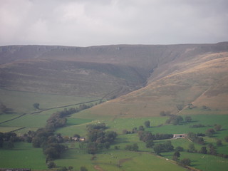
The Great Ridge, from near Manor House Farm
SWC Walk 302 - Bamford to Edale (via Win Hill and Great Ridge)
Sep-17 • thomasgrabow on Flickr
swcwalks swcwalk302 banner 24372083608
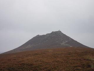
Win Hill Pike, from Thornhill Brink
SWC Walk 302 - Bamford to Edale (via Win Hill and Great Ridge)
Sep-17 • thomasgrabow on Flickr
swcwalks swcwalk302 walkicon 38244371901
![Great Ridge (Mam Tor and Hollins Cross) from Path by Goosehill Hall, Castleton SWC Walk 302 - Bamford to Edale (via Win Hill and Great Ridge) [Castleton Alternatives]](https://live.staticflickr.com/4516/37533175294_06b8ca6436_n.jpg)
Great Ridge (Mam Tor and Hollins Cross) from Path by Goosehill Hall, Castleton
SWC Walk 302 - Bamford to Edale (via Win Hill and Great Ridge) [Castleton Alternatives]
Sep-17 • thomasgrabow on Flickr
swcwalks swcwalk302 walkicon 37533175294
![Win Hill from Path by Goosehill Hall, Castleton SWC Walk 302 - Bamford to Edale (via Win Hill and Great Ridge) [Castleton Alternatives]](https://live.staticflickr.com/4574/38244171951_8b37d7ea6f_n.jpg)
Win Hill from Path by Goosehill Hall, Castleton
SWC Walk 302 - Bamford to Edale (via Win Hill and Great Ridge) [Castleton Alternatives]
Sep-17 • thomasgrabow on Flickr
swcwalks swcwalk302 walkicon 38244171951
![Winnats Pass with Win Hill Pike SWC Walk 302 - Bamford to Edale (via Win Hill and Great Ridge) [Castleton Alternatives]](https://live.staticflickr.com/4519/24372292898_f6825820e9_n.jpg)
Winnats Pass with Win Hill Pike
SWC Walk 302 - Bamford to Edale (via Win Hill and Great Ridge) [Castleton Alternatives]
Sep-17 • thomasgrabow on Flickr
swcwalks swcwalk302 walkicon 24372292898

Descending Chapel Gate
SWC Walk 302 - Bamford to Edale (via Win Hill and Great Ridge)
Sep-17 • thomasgrabow on Flickr
swcwalks swcwalk302 walkicon 38189034596
Ollersbrook Clough and Ringing Roger, from The Great Ridge
SWC Walk 302 - Bamford to Edale (via Win Hill and Great Ridge)
Sep-17 • thomasgrabow on Flickr
swcwalks swcwalk302 37533566854
| Length | 20.3 km (12.6 mi), with 846/753m ascent/descent. For a shorter or longer walk see below Walk Options. |
|---|---|
| Toughness | 7 out of 10, with 6 ½ hours walking time. For the whole outing, including trains, sights and meals, allow at least 13 hours. |
| Walk Notes |
This walk cuts through the boundary land between the Dark and White Peak areas of the Peak District National Park. A steep ascent up to Win Hill opens tremendous views to the surrounding Upper Derwent Valley reservoirs, the Vales of Edale and Hope and the exposed and isolated tracts of rugged moorlands, covered by cotton grass bogs and heather, and dramatically sculpted gritstone escarpments (or ‘edges’) of the Peak District’s iconic Dark Peak area.
Despite a lunch pub just off route, this walk lends itself to a picnic lunch on one of the tops or on the ridge. Diversions to lunch or a finish in Hope and Castleton are described, as are an alternative start from Hope Station and shortcuts from the Great Ridge to Edale, as well as an extension across Brown Knoll’s upland peat bog and down from the head of the Vale of Edale via Jacob’s Ladder (path). |
| Walk Options |
An Alternative Start from Hope Station cuts 4.9 km/3.0 mi and 263m ascent and is rated 5/10. Diversions down from the Great Ridge to Hope and Castleton villages for lunch or an early finish:
A couple of Shortcuts lead down from the Great Ridge to Edale:
An Extension across Brown Knoll’s upland peat bog and down from the head of the Vale of Edale via Jacob’s Ladder adds 5.4 km/3.4 mi and 172m ascent, and is rated 9/10. |
| Maps |
OS Explorer: OL1 (The Peak District – Dark Peak Area)
|
| Travel |
Bamford station, map reference SK 207 825, is 16 km south west of Sheffield and 230 km north west of Charing Cross and 151m above sea level. Edale Station, map reference SK 122 853, is 245m above sea level. Both are in Derbyshire. Bamford Station is on the Hope Valley Line from Manchester to Sheffield, with a journey time of 22 mins from Sheffield. Edale Station is a few stops and 9 minutes journey time further west in the direction of Manchester. Sheffield Station is the terminus of the Midland Main Line from London St. Pancras, with up to two trains per hour (journey time from 116 mins Mon-Sat, longer on Sundays). Saturday Walkers’ Club: Take a train no later than 9.00 hours. |
| Lunch |
The Cheshire Cheese Inn Edale Rd, Hope, Derbyshire, S33 6ZF (01433 620 381). The Cheshire Cheese is located 500m off route, after 8.4 km (5.2 mi) of walking. |
| Lunch/Tea (off route) |
In Hope
In Castleton
|
| Tea (in Edale) |
The Penny Pot Café Station Approach, Edale, Hope Valley, Derbyshire, S33 7ZA (01433 670 688).
|
| Profile | |
|---|---|
| Help Us! |
After the walk, please leave a comment, it really helps. Thanks! You can also upload photos to the SWC Group on Flickr (upload your photos) and videos to Youtube. This walk's tags are: |
| By Train |
Out (not a train station) Back (not a train station) |
| By Car |
Start S33 0AH Map Directions Return to the start: Finish S33 7ZN Map Directions Travel to the start: |
| Amazon | |
| Help |
National Rail: 03457 48 49 50 • Traveline (bus times): 0871 200 22 33 (12p/min) • TFL (London) : 0343 222 1234 |
| Version |
Apr-24 Thomas G |
| Copyright | © Saturday Walkers Club. All Rights Reserved. No commercial use. No copying. No derivatives. Free with attribution for one time non-commercial use only. www.walkingclub.org.uk/site/license.shtml |

Walk Directions
Full directions for this walk are in a PDF file (link above) which you can print, or download on to a Kindle, tablet, or smartphone.
This is just the introduction. This walk's detailed directions are in a PDF available from wwww.walkingclub.org.uk