Blackheath to Deptford walk
Genteel streets, grand houses, a large heathland with views, well-kept parks, a Victorian cemetery and green hills with magnificent views

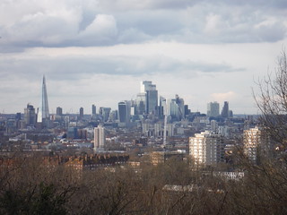
The City of London, from One Tree Hill
SWC Walk 421 - Blackheath to Deptford (Hills & Parks of Inner Southeast London)
03-Mar-24 • thomasgrabow on Flickr
swcwalks swcwalk421 banner 53566670357

The Paragon, Blackheath
SWC Walk 421 - Blackheath to Deptford (Hills & Parks of Inner Southeast London)
03-Mar-24 • thomasgrabow on Flickr
swcwalks swcwalk421 walkicon 53567720828

View across the Heath from Mount's Pond, Blackheath
SWC Walk 421 - Blackheath to Deptford (Hills & Parks of Inner Southeast London)
03-Mar-24 • thomasgrabow on Flickr
swcwalks swcwalk421 walkicon 53566672402

St. Margaret of Antioch, Lee Green
SWC Walk 421 - Blackheath to Deptford (Hills & Parks of Inner Southeast London)
03-Mar-24 • thomasgrabow on Flickr
swcwalks swcwalk421 walkicon 53567719633

Canary Wharf, from Blythe Hill Fields
SWC Walk 421 - Blackheath to Deptford (Hills & Parks of Inner Southeast London)
03-Mar-24 • thomasgrabow on Flickr
swcwalks swcwalk421 walkicon 53566670862

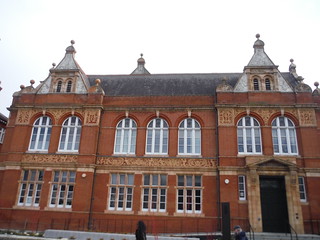
Blackheath Halls
SWC Walk 421 - Blackheath to Deptford (Hills & Parks of Inner Southeast London)
03-Mar-24 • thomasgrabow on Flickr
swcwalks swcwalk421 53567526946

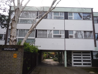
Spangate (Eric Lyons for Span Developments), Blackheath Park
SWC Walk 421 - Blackheath to Deptford (Hills & Parks of Inner Southeast London)
03-Mar-24 • thomasgrabow on Flickr
swcwalks swcwalk421 53567967015
| Length |
22.2 km (13.8 mi), with 213/228m ascent/descent. For a shorter walk, see below Walk Options. |
|---|---|
| Toughness |
4 out of 10, with 5 hours walking time. For the whole outing, including trains, sights and meals, allow at least 6 ½ hours. |
| Walk Notes |
This is an urban route almost entirely in the London Borough of Lewisham, stringing together some genteel residential areas and streets, a large heathland with views, many well-kept parks (some with rivers running through them), a large Victorian cemetery and plenty of hills-with-views to either Crystal Palace and the North Downs, Canary Wharf, the City of London and/or the West End and Nine Elms. You start with a long loop through the acclaimed Blackheath Cator Estate, a Victorian and Georgian private estate with some impressive large houses and tree-lined wide and quiet streets, but also sprinkled with award-winning modernist houses. From there, traverse the upland heath and descend into Lee, also with streets full of attractive residences, some almshouses, a Manor House with a fine park, and the River Quaggy. On through Hither Green to a hill-park-with-views and down across the Ravensbourne Valley. The Brockley Three Peaks await next, with Brockley and Ladywell Cemetery walked through in-between. The final stretch leads over Telegraph Hill into Hatcham (New Cross) and on to Deptford. All the route is on hard surfaces and mud-free. Alternative earth or gravel paths are shown on the map.
The route shares its start with SWC Walk #swc215 - Blackheath to Canary Wharf and has minimal overlap with two Short Walks: #short36 - Waterlink Way and #short41 - Nunhead, Honor Oak & Peckham Rye. It can be split into attractive (evening) short walks. |
| Walk Options |
An Early Shortcut, straight from the station, cuts out the loop through Blackheath Park and across the Heath. It cuts 2.9 km and 20m ascent.
|
| Credits |
Inspiration for the first part of this route and background for some of the houses in the Blackheath Cator Estate have come from the printed booklet ‘Perambulation No 5 – Blackheath South London, A Walking Guide to Modernist Houses’ by Stefi Orazi (https://www.stefiorazi.co.uk/ |
| Maps |
OS Landranger: 162 (Greenwich & Gravesend)
|
| Transport |
Blackheath Station, map reference TQ 395 760, is 10 km south east of Charing Cross and 20m above sea level. Deptford Station is 3 km north west of it and 5m above sea level. Both are in Greater London. Blackheath Station is in Travelcard Zone 3 and lies in the south of Blackheath village near the boundary with Lee. It is served by trains on the North Kent Line and the Bexleyheath Line, which split just east of the station. Journey times are 20 minutes from Charing Cross and 18 minutes from Cannon Street. Deptford Station lies on the Greenwich Line and is the oldest station in London still in use, served by trains from Cannon Street with a journey time of 10 minutes and in Travelcard Zone 2. Saturday Walkers’ Club: Start the walk at any time, as lunch and tea options appear at regular intervals. |
| Food & Drink |
Leading through fully gentrified parts of Inner London, a plethora of good refreshment options are passed. See page 2 of the pdf for details. |
| Profile | |
|---|---|
| Help Us! |
After the walk, please leave a comment, it really helps. Thanks! You can also upload photos to the SWC Group on Flickr (upload your photos) and videos to Youtube. This walk's tags are: |
| By Train |
Out (not a train station) Back (not a train station) |
| By Car |
Start SE3 9LE Map Directions Return to the start: Finish SE8 3NU Map Directions Travel to the start: |
| Amazon | |
| Help |
National Rail: 03457 48 49 50 • Traveline (bus times): 0871 200 22 33 (12p/min) • TFL (London) : 0343 222 1234 |
| Version |
Apr-24 Thomas G |
| Copyright | © Saturday Walkers Club. All Rights Reserved. No commercial use. No copying. No derivatives. Free with attribution for one time non-commercial use only. www.walkingclub.org.uk/site/license.shtml |
Walk Directions
Full directions for this walk are in a PDF file (link above) which you can print, or download on to a Kindle, tablet, or smartphone.
This is just the introduction. This walk's detailed directions are in a PDF available from wwww.walkingclub.org.uk

