Blorenge from Abergavenny walk
Initial brutal ascent then gentle contours along a tramroad, past ruins of the industrial past to Blorenge's upland plateau. Fantastic views of Usk Valley and Black Mountains

Blorenge/Blorens, from Castle Meadows, Abergavenny
SWC Walk 372 - Blorenge (Abergavenny Circular)
Aug-20 • thomasgrabow on Flickr
swcwalks swcwalk372 banner 50371630641
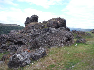
Slag Heap, Garnddyrys Forge
SWC Walk 372 - Blorenge (Abergavenny Circular)
Aug-20 • thomasgrabow on Flickr
banner swcwalks swcwalk372 50371791807

Blorenge: the Bronze Age Carn Blorenge and the trigpoint
SWC Walk 372 - Blorenge (Abergavenny Circular)
Aug-20 • thomasgrabow on Flickr
banner swcwalks swcwalk372 50370929883
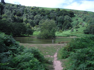
The Punchbowl, Blorenge
SWC Walk 372 - Blorenge (Abergavenny Circular)
Aug-20 • thomasgrabow on Flickr
banner swcwalks swcwalk372 50371791242

Ysgyryd Fawr/The Skirrid, from easterly slopes of Blorenge, near Castell Prydydd
SWC Walk 372 - Blorenge (Abergavenny Circular)
Aug-20 • thomasgrabow on Flickr
banner swcwalks swcwalk372 50371791142

Coastline east of Newport, with Somerset beyond; from top of Blorenge
SWC Walk 372 - Blorenge (Abergavenny Circular)
Aug-20 • thomasgrabow on Flickr
walkicon swcwalks swcwalk372 50371791582

Llanfoist Wharf on the Monmouthshire and Brecon Canal
SWC Walk 372 - Blorenge (Abergavenny Circular)
Aug-20 • thomasgrabow on Flickr
walkicon swcwalks swcwalk372 50371791057
| Length |
19.6 km (12.2 mi), with 723m ascent/descent. For a shorter or longer walk see below Walk Options. |
|---|---|
| Toughness |
7 out of 10, with 6 hours walking time. |
| Walk Notes |
This expedition through parts of the Blaenavon World Heritage Site up to one of Abergavenny’s mountains, features some stunning views and interesting industrial heritage elements. From the pretty town centre of Abergavenny walk along the curtain wall of Abergavenny Castle and through the Castle Meadows along the River Usk to cross over into Llanfoist and start the ascent up the Blorenge. You go through the Llanfoist tunnel under the Monmouthshire & Brecon canal and commence the quite brutal ascent up through Glebe Wood to the Cwm Craf along the three former Llanfoist Inclines of the tramway linking the canal to some ironworks and quarries on the side of and beyond the Blorenge. From the top of the inclines, a further, very gradual ascent around the side of the Blorenge and through the fascinating former site of the Garnddyrys Forge leads you up a tightening Cwm to the hill’s summit plateau, on a fine weather day with superlative views to the Bristol Channel, the Malverns and Cotswolds and – across the Usk Valley – to the Black Mountains.
An interesting but long extension leads down the far side of Blorenge into the Cwm Lwyd and past many core sites of the Blaenavon Industrial Heritage site. |
| Walk Options |
A start/finish at Abergavenny Bus Station cuts 750m each way and 30m ascent at the end of the walk. Pick up the directions at the end of the second paragraph.
An Extension dips down the far side of Blorenge into the Cwm Lwyd to the core part of the Blaenavon World Heritage Site, famous for many relics of the heavy industrial history of the Welsh Valleys, including The Big Pit National Mining Museum. This highly interesting detour adds 9.9 km and 250m ascent though (9/10)!
|
| Maps |
OS Explorer: OL 13 (Brecon Beacons NP East)
|
| Travel |
Abergavenny Station, map reference SO 305 136, is 30 km south east of Brecon, 202 km west northwest of Charing Cross, 74m above sea level and in Monmouthshire, Wales. It is served by the Welsh Marches Line (Newport – Hereford), connecting at Newport to Paddington, with mostly two trains per hour (total journey time from 135 mins). Abergavenny Bus Station is passed early on, bus lines with regular and useful connections are: 23 (Hereford – Newport), 43/X43 (Brecon – Abergavenny), 83 (Monmouth – Abergavenny). Saturday Walkers’ Club: Take a train no later than 09.45. |
| Lunch |
Picnic. |
| Tea |
The Bridge Inn Merthyr Road, Llanfoist, Abergavenny, NP7 9LH (01873 854 831). The Bridge Inn is located 2.2 km from the end of the walk and 1.5 km from Abergavenny Bus Station. Plenty of places in Abergavenny’s Town Centre. See the walk directions for details. |
| Lunch/Tea Blaenavon Extension |
The Whistle Inn & Campsite The Whistle Inn is located 12.6 km into the walk.
|
| Welsh Glossary |
aber: estuary, confluence, river mouth; afon: river; affwys: abyss; allt: hillside, cliff; aran: high place; ban/fan/bannau (pl): peak/beacon/crest, hill/mountain; big: peak; blaen: source of river, head of valley; bod: dwelling; bre: hill; bron: hill-breast; bryn: hill; bwlch: gap/col/pass; cadair: chair; cae: field; caer/gaer: stronghold, fort; capel: chapel; carn/garn/carnedd/garnedd: cairn, heap of stones, tumulus; carreg/garreg: stone, rock; castell: castle; cefn: ridge, hillside; celli: grove/copse; cerwyn: pot-hole; cist: chest; clog/clogwyn: cliff; clun: meadow; clwyd: hurdle/gate; clydach: torrent; coch/goch: red; coed: wood; craig/graig: rock; crib/cribyn: crest, ridge, summit; crug: mound; cul: narrow; cwm: hanging valley/corrie/bowl/dale; cyfrwy: ridge between two summits (saddle); ddinas: fort; dibyn: steep slope, precipice; dim: no; din: hill-fortress; disgwylfa: place of observation, look-out point; dôl: meadow; du/ddu: black, dark; dwfr/dŵr: water; dyffryn: valley; -dyn: fortified enclosure; eglwys: church; eira: snow; eisteddfod: meeting-place, assembly; esgair: ridge; fach/bach: small; fawr/mawr: large; fechan: smaller; ffald: sheep-fold, pound, pen, run; ffordd: way, road; ffridd: pasture; ffrwd: stream, torrent; ffynnon: spring/well; gallt: wooded hill; ganol: middle; garth: promontory, hill, enclosure; glan/lan: river-bank, hillock; glas: green (when referring to grass, pasture or leaves), blue (when relating to the sea or air); glyn: deep valley, glen; gors: bog; gorsedd: tumulus, barrow, hillock; gwyddfa: mound, tumulus; gwylfa: look-out point; gwyn/gwen: white; gwynt: wind; hafn: gorge, ravine; hafod: summer dwelling; hen: old; hendre(f): winter dwelling, old home, permanent abode; heol: road; hesgyn: bog; hir: long; is: below, lower; isaf: lower/lowest; llan: church, monastery; llawr: level area, floor of valley; llech: slab, stone, rock; llther: slope; lluest: shieling, cottage, hut; llwch: lake, dust; llwybr: path; llwyd: grey, brown; llwyn: bush, grove; llyn: lake; llynwyn: pool/puddle, moat; maen: stone; maes: open field, plain; mawn: peat; mawnog: peat-bog; melyn: yellow; merthyr: burial place, church; moel/foel: bare, bald/bare hill; mynydd: mountain, moorland; nant: brook/stream, dingle/glen; neuadd: hall; newydd: new; ogof/gogof: cave; pant: hollow; parc: park, field, enclosure; pen: head, top/end, edge; penrhyn: promontory; pentre(f): homestead, village; perfedd: middle; perth: bush, brake, hedge; plas: hall, mansion; pont/bont: bridge; porth: gate/gateway, harbour/bay/landing-place/ferry; pwll: pit, pool; rhiw: hill, slope; rhos: moor, promontory; rhudd: red, crimson; rhyd: ford; sarn: causeway; sgwd/rhaeadr: waterfall; sticill: stile; sych: dry; tafarn: tavern; tâl: end, top; talar: headland (of field); tan/dan: below; tarren/darren: escarpment; tir: land, territory; tor: break, gap; tre/tref: settlement, hamlet, town; twlch: tump, knoll; twll: hole, pit; tŵr: tower; twyn: hill; tŷ: house; uchaf: upper, highest; uwch: above, over; waun/gwaun: moorland, meadow; wen/wyn: white; y, yr, ‘r: the; ynys: island, holm, river-meadow; ysgol: ladder, formation on mountain-side/school; ysgwydd: shoulder (of mountain); ystafell: chamber, hiding-place; ystrad: wide valley, holm, river-meadow. |
|---|---|
| Profile | |
| Help Us! |
After the walk, please leave a comment, it really helps. Thanks! You can also upload photos to the SWC Group on Flickr (upload your photos) and videos to Youtube. This walk's tags are: |
| By Train |
Out (not a train station) Back (not a train station) |
| By Car |
Start NP7 5HS Map Directions |
| Amazon | |
| Help |
National Rail: 03457 48 49 50 • Traveline (bus times): 0871 200 22 33 (12p/min) • TFL (London) : 0343 222 1234 |
| Version |
Apr-24 Thomas G |
| Copyright | © Saturday Walkers Club. All Rights Reserved. No commercial use. No copying. No derivatives. Free with attribution for one time non-commercial use only. www.walkingclub.org.uk/site/license.shtml |


Walk Directions
Full directions for this walk are in a PDF file (link above) which you can print, or download on to a Kindle, tablet, or smartphone.
This is just the introduction. This walk's detailed directions are in a PDF available from wwww.walkingclub.org.uk