Bradford-on-Avon to Bath walk
Follow the tranquil Kennet and Avon Canal through a pretty valley between the historic towns of Bradford-upon-Avon and Bath
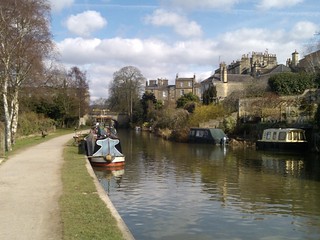
The canal in Bath
Bath to Bradford-upon-Avon walk
Mar-13 • Saturdaywalker on Flickr
book3 walk6 swcwalks 8619643695
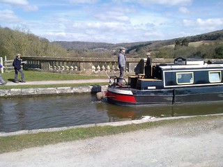
Crossing the Dundas Aqueduct
Bath to Bradford-upon-Avon walk
Mar-13 • Saturdaywalker on Flickr
book3 walk6 swcwalks 8619643705

The Avon from the Dundas Aqueduct
Bath to Bradford-upon-Avon walk
Mar-13 • Saturdaywalker on Flickr
book3 walk6 swcwalks 8620744666

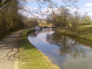
Typical scene
Bath to Bradford-upon-Avon walk
Mar-13 • Saturdaywalker on Flickr
book3 walk6 swcwalks 8619643465

Bridge near Avoncliff
Bath to Bradford-upon-Avon walk
Mar-13 • Saturdaywalker on Flickr
book3 walk6 swcwalks 8619643243

The Avoncliff Aqueduct
Bath to Bradford-upon-Avon walk
Mar-13 • Saturdaywalker on Flickr
book3 walk6 swcwalks 8620744148
| Length | 9.9 miles. Flat. Hard surface. About 4.5 hours plus pub and cream tea stops. |
|---|---|
| Toughness | 2 out of 10 |
| Maps | OS Explorers: 155 and 156 |
| Features |
This lovely and very easy walk starts in the beautiful historic town of Bradford-upon-Avon, and follows the Kennet and Avon canal along its towpath following a beautiful steep sided valley, crossing the river Avon twice on aqueducts. The canal is elevated above the river, giving nice views throughout (but better in winter near the start). The walk finishes in Georgian Bath. There is a nice selection of pubs and tea rooms along the way. The walk can be done in either direction - Bradford is also a pretty town to finish in. |
| Walk Options |
|
| Author's Note |
I used to take the train from Waterloo to South Wales which follows the picturesque river valley alongside the canal as it winds its way towards Bristol - the canal being clearly visible from the train on the far side of the valley. So, one time, I stopped off and walked... There is an alternate riverside (as opposed to canalside) path from Bradford-upon-Avon to Avoncliffe (the first aqueduct), however, there's no river view, and its muddy, even in summer - stick to the canal path. |
| Travel |
By Train Bradford-on-Avon has a train service from both London Paddington (2 hrs, change at Bath) and London Waterloo (2 hrs 15 to 3 hrs, direct (rare) or change at Salisbury) Bath has a fast (1 hr 30 mins, direct) train service from London Paddington, and a much slower one from London Waterloo (2 hrs 30 mins, direct (rare) or change at Salisbury). However, there are problems: 1) these stations are outside the Netword Card area, which makes the journey more expensive, and 2) the tickets on the fast trains from Paddington are much more expensive than the slower ones from Waterloo Travel by the fastest route: out via either Waterloo or Paddington, return to Paddington.
Travel by the cheapest route: out and back from Waterloo via Salisbury.
Consider doing the walk in reverse, if the train times are more convenient Fare advice updated: Sep'19 By Car : About 2 hrs 15 mins from London. There is a pay car park at Bradford-upon-Avon train station, and a free visitors car-park by the canal. Return to your car by direct train, about 10 mins. Also, free parking by Avoncliffe station, and a pay car park at Dundas Aqueduct cafe. All of Bath is in a CPZ If making a weekend of it, Bristol (heritage harbour area), Avebury (stone circle) and Glastonbury (hippies) are nearby. Saturday Walkers Club : Publicise the walk a few weeks in advance to allow advance tickets to be purchased, or take advantage of occasional special offers. |
| History |
|
| Lunch |
There are several pubs and tea rooms en-route. Including...
|
| Profile | |
|---|---|
| Help Us! |
After the walk, please leave a comment, it really helps. Thanks! You can also upload photos to the SWC Group on Flickr (upload your photos) and videos to Youtube. This walk's tags are: |
| By Train |
Out (not a train station) Back (not a train station) |
| By Car |
Start BA15 1DF Map Directions Return to the start: Finish BA1 1SU Map Directions Travel to the start: |
| Map Walk | This walk requires an OS map and a compass or GPS for navigation. You can print out OS maps using the link above. |
| Amazon | |
| Help |
National Rail: 03457 48 49 50 • Traveline (bus times): 0871 200 22 33 (12p/min) • TFL (London) : 0343 222 1234 |
| Version |
Apr-24 Andrew |
| Copyright | © Saturday Walkers Club. All Rights Reserved. No commercial use. No copying. No derivatives. Free with attribution for one time non-commercial use only. www.walkingclub.org.uk/site/license.shtml |


Walk Directions
This is a very easy to follow walk, just follow the canal! (NB not the river - there is an River Avon walkway for much of the route as well)
Bradford-upon-Avon station to Avoncliff Aqueduct
- Exit Bradford-upon-Avon station, walk to your right, past the car park, to the road junction.
- To explore the town: turn left to visit the historic centre with many 17thC buildings. Then retrace your steps to this point.
- To continue the main walk, turn right. Continue for 200 meters. Pass Pound Lane, and then a park, on your right hand side.
- Just before the hump back bridge over the canal, veer right on a small road. Follow it for 20 meters to the canal towpath. There are 2 pubs here.
- Turn right along the canal, and then follow the towpath, with the canal on your left hand side.
- After 3 km/2 miles, just past the Cross Guns pub, you come to the Avoncliff Aqueduct (a bridge carrying the canal over the river).
- Just before the aqueduct, cross under the canal to the other side, and follow the towpath over the aqueduct. You can see Avoncliff Station and a weir.
- Continue on along the towpath with the canal on your right.
Avoncliffe Aqueduct to the Dundas Aqueduct / Canal Junction
- After 2km/1.5 miles, Freshford Station is visible on the other side of the Valley
- After 2 km/1.5 miles, you reach the Dundas Aqueduct where the canal crosses back over the river. At the end of it, you come to a canal "T junction".
- To go to the Angelfish Cafe and canal visitor centre, turn left along a signposted path, and follow the canal spur for 0.8km. Afterwards, retrace your steps to this point.
- To continue the main walk, cross a lock over the canal spur, and turn right. Follow the path, crossing a bridge to the opposite bank
- The canal is now on your left. Continue on towards Bath.
Dundas Aqueduct / Canal Junction to Bath
- Follow the canal for 5km/3 miles, until you reach Bathampton, which has The George Inn, a canalside pub with a canalside terrace.
- After a further 2 km/1.5 miles, the canal and towpath goes under a fine house and into a cutting. This is close to Bath town centre.
- To go to Bath's historic centre: Turn right at this point for a shortcut into the town centre.
- After 1 km/0.7 miles, the canal comes out into the open again. The river is visible below to the right, and the train station becomes visible on the other side of the river.
- Keep following the canal towpath, crossing over a few roads, and passing some locks.
- Leave the canal just before it finally joins the river. Walk up to the road, and take the footbridge over the river towards the station.
- Walk through a tunnel (beneath the platforms), and Bath station entrance is on your left hand side.