Buxton Circular or to Monsal Dale (via the Wye Valley) Walk
A very scenic White Peak dale: tight gorges, limestone crags, steeping stones, cascades, mills. Elevated pastures back to Buxton. Or on to Monsal Head with its famous vistas

First set of Stepping Stones. Chee Dale
SWC 385 - Buxton Circular or to Monsal Dale (via the Wye Valley)
Aug-21 • thomasgrabow on Flickr
swcwalks swcwalk385 banner 51487626165
![Headstone Viaduct and Monsal Dale from Monsal Head Viewpoint SWC 385 - Buxton Circular or to Monsal Dale (via the Wye Valley) [Alternative Ending at Monsal Dale]](https://live.staticflickr.com/65535/51485910507_42ae0553b3_n.jpg)
Headstone Viaduct and Monsal Dale from Monsal Head Viewpoint
SWC 385 - Buxton Circular or to Monsal Dale (via the Wye Valley) [Alternative Ending at Monsal Dale]
Aug-21 • thomasgrabow on Flickr
swcwalks swcwalk385 banner 51485910507
![Backview to Monsal Trail, from elevated route along Water-cum-Jolly Dale SWC 385 - Buxton Circular or to Monsal Dale (via the Wye Valley) [Alternative Ending at Monsal Dale - Elevated Route]](https://live.staticflickr.com/65535/51487407094_b0167a7db2_n.jpg)
Backview to Monsal Trail, from elevated route along Water-cum-Jolly Dale
SWC 385 - Buxton Circular or to Monsal Dale (via the Wye Valley) [Alternative Ending at Monsal Dale - Elevated Route]
Aug-21 • thomasgrabow on Flickr
swcwalks swcwalk385 banner 51487407094
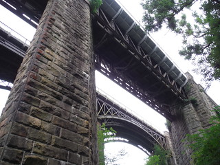
Miller's Dale Viaducts, from road below
SWC 385 - Buxton Circular or to Monsal Dale (via the Wye Valley)
Aug-21 • thomasgrabow on Flickr
swcwalks swcwalk385 walkicon 51486698286

View up the Wye Valley, after rising out of Chee Dale
SWC 385 - Buxton Circular or to Monsal Dale (via the Wye Valley)
Aug-21 • thomasgrabow on Flickr
swcwalks swcwalk385 walkicon 51486698901
| Length |
26.0 km (16.1 mi), with 719m ascent/descent. For a shorter or longer walk see below Walk Options. |
|---|---|
| Toughness |
8 out of 10, with 7 ¼ hours walking time. |
| Walk Notes |
Explore the most beautiful stretch of one of the most famous dales of the White Peak from historical Buxton.
An Alternative Ending follows the Wye Valley further past the former Litton and Cressbrook Mills, notorious for their working conditions at the time, and through a nature reserve up to Monsal Head for tea, with its renowned views down to a wide bend in the valley and to a very pretty viaduct. A quiet stretch through Monsal Dale to a bus stop on the A6 rounds off the route. A tougher version of that alternative ending follows an exposed path high up on the other side of the valley. |
| Walk Options |
Some of the paths – and also the stepping stones – along the Wye are prone to being under water after heavy rain. The Monsal Trail, running though the Wye Valley along a dismantled railway line, affords escapes to a higher level in several spots. These are obvious on the route map and highlighted in the directions. Shortcuts
Extensions/Alternative Endings
|
| Maps |
OS Explorer: OL24 (The Peak District – White Peak Area)
|
| Travel |
Buxton Station, map reference SK 059 737, is 22km southeast of Manchester, 299m above sea level. Monsal Dale, White Lodge Car Park Bus Stop, map reference SK 168 707, is 221 km northwest of London, 167m above sea level. Both are in Derbyshire. Buxton Station is the terminus of the Buxton Line from Manchester, with two trains per hour Mon-Sat daytime and one per hour else. Journey time is 60 mins from Manchester and ca. three hours from London (chg. at Stockport). A faster connection can be obtained by taking a train to Macclesfield and bus 58 to Buxton. Monsal Dale, White Lodge Car Park Bus Stop is served by Transpeak 3 (Matlock – Buxton, hourly every day). Saturday Walkers’ Club: The walk is doable as a daywalk from London with a train no later than 08.20 hours. |
| Elenvenses |
Blackwell Mill Cycle Hire and Tuck Shop 8 Blackwell Mill Cottages, Bakewell Road, Buxton SK17 9TE (01298 708 38). The Tuck Shop is located 60m off route, 7.5 km (4.7 mi) into the walk. |
| Lunch |
Angler’s Rest Miller’s Dale, Buxton, Derbyshire SK17 8SN (01298 871 323). The Angler’s Rest is located 11.8 km (7.3 mi) into the walk.
|
| Tea |
Beech Croft Farm Caravan & Camp Site Blackwell, Taddington, Derbyshire,SK17 9TQ (01298 853 30). Beech Croft Farm is located 70m off route, 15.0 km (9.3 mi) into the walk. Their Store in the reception building is selling hot and cold drinks and some cold food, and has outdoor seating (some covered). It is open all day every day, and happy to sell to non-residents. The next-door Daisies Coffee Shop has opened in 08/2021. Check the website for the latest on their opening hours and offerings.
Tea Monsal Dale Ending - located 2.8 km from the end of the Alternative Ending
|
| Profile | |
|---|---|
| Help Us! |
After the walk, please leave a comment, it really helps. Thanks! You can also upload photos to the SWC Group on Flickr (upload your photos) and videos to Youtube. This walk's tags are: |
| By Train |
Out (not a train station) Back (not a train station) |
| By Car |
Start Map Directions |
| Amazon | |
| Help |
National Rail: 03457 48 49 50 • Traveline (bus times): 0871 200 22 33 (12p/min) • TFL (London) : 0343 222 1234 |
| Version |
Sep-22 Thomas G |
| Copyright | © Saturday Walkers Club. All Rights Reserved. No commercial use. No copying. No derivatives. Free with attribution for one time non-commercial use only. www.walkingclub.org.uk/site/license.shtml |

Walk Directions
Full directions for this walk are in a PDF file (link above) which you can print, or download on to a Kindle, tablet, or smartphone.
This is just the introduction. This walk's detailed directions are in a PDF available from wwww.walkingclub.org.uk