Buxton Circular via Axe Edge Moor and Three Shires Head walk
The vast Axe Edge Moor, the heads of 5 famous Peak District rivers, the popular and scenic Three Shires Head pools and waterfalls, disused quarries and some fine far views
Shutlingsloe in continuation of road by New Lodge Farm, Flash Bar/Hilltop
SWC 387 - Buxton Circular (via Axe Edge Moor and Three Shires Head)
Aug-21 • thomasgrabow on Flickr
swcwalks swcwalk387 banner 51486550024
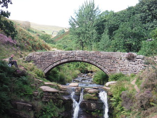
Panniers Bridge over River Dane, by Three Shires Head
SWC 387 - Buxton Circular (via Axe Edge Moor and Three Shires Head)
Aug-21 • thomasgrabow on Flickr
swcwalks swcwalk387 banner 51485838391
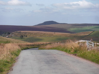
View down old Macclesfield Turnpike Road to Axe Edge Moor
SWC 387 - Buxton Circular (via Axe Edge Moor and Three Shires Head)
Aug-21 • thomasgrabow on Flickr
swcwalks swcwalk387 banner 51485840386

Solomon's Temple, Folly on Grin Low, Buxton Country Park
SWC 387 - Buxton Circular (via Axe Edge Moor and Three Shires Head)
Aug-21 • thomasgrabow on Flickr
swcwalks swcwalk387 walkicon 51486053293

View from Flash across to Shutlingsloe, past Cut-thorn Hill
SWC 387 - Buxton Circular (via Axe Edge Moor and Three Shires Head)
Aug-21 • thomasgrabow on Flickr
swcwalks swcwalk387 walkicon 51486054708
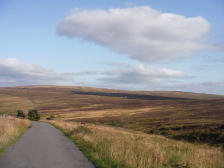
View down the Dane Valley from Back ‘oth Cross Cottage
SWC 387 - Buxton Circular (via Axe Edge Moor and Three Shires Head)
Aug-21 • thomasgrabow on Flickr
swcwalks swcwalk387 walkicon 51485837891
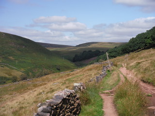
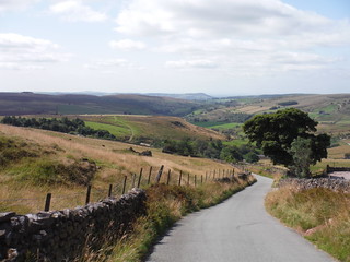
Cut-thorn Hill on left, Danebower and Whetstone Ridge ahead
SWC 387 - Buxton Circular (via Axe Edge Moor and Three Shires Head)
Aug-21 • thomasgrabow on Flickr
swcwalks swcwalk387 walkicon 51485053247
| Length |
27.1 km (16.8 mi), with 687m ascent/descent. For a shorter or longer walk see below Walk Options. |
|---|---|
| Toughness |
8 out of 10, with 7 hours walking time. |
| Walk Notes |
You rise steeply out of the spa town of Buxton up the now wooded Grin Low, a formerly heavily quarried hill, with its hilltop folly, Solomon’s Temple, and a viewing platform. Continue through pastures higher up to the vast upland Axe Edge Moor, source of five of the most famous Peak District rivers: the Wye, Dove, Manifold, Dane and Goyt. The tops of all those valleys will be visited. The moor crossings are largely along broad grassy or gravel paths, but not without one stretch with ‘proper’ moorland terrain: bouncy to boggy, at times ill defined, paths passing groughs, cloughs and peat hags. Various remnants of historic mining activities are passed, some quite picturesque. On a good day the moor provides for fantastic views into the surrounding valleys, to neighbouring ridges and quarries and into the Cheshire Plain.
|
| Walk Options |
Buses at the start
A Shortcut follows the Dane Valley Way around Cheeks Hill and down the very scenic-in-its-starkness Black Clough. This cuts out the middle section of the walk, i.e.: 5.7 km length and 172m ascent (6/10).
Bus Line 58 (Macclesfield – Buxton via Cat & Fiddle), with an hourly service Monday-Saturday and five buses on Sundays and Bank Holidays, offers several stops on the route to shorten the walk by finishing the route early.
|
| Maps |
OS Explorer: OL24 (The Peak District – White Peak Area)
|
| Travel |
Buxton Station, map reference SK 059 737, is 22km southeast of Manchester, 299m above sea level and in Derbyshire. Buxton Station is the terminus of the Buxton Line from Manchester, with two trains per hour Mon-Sat daytime and one per hour else. Journey time is 60 mins from Manchester and ca. three hours from London (chg. at Stockport). A faster connection can be obtained by taking a train to Macclesfield and bus 58 to Buxton. Saturday Walkers’ Club: The walk is doable as a daywalk from London with a train no later than 07.20 hours. |
| Elenvenses/Lunch |
Flash Bar Café and Shop The Annexe, A53, Quarnford Flash Bar, Staffordshire, SK17 0TF (01298 27804). Flash Bar Café and Shop are located 10.5 km (6.5 mi) into the walk. Flash Bar takes its name from the toll bar and house built in 1771 which is still in existence today. It was in operation on the site of the then road from Macclesfield to Longnor via Three Shires Head.
|
| Tea |
The Cat & Fiddle Buxton New Road, Macclesfield, Cheshire, SK11 0AR (01298 73711). The Cat & Fiddle is located 7.1 km from the end of the walk. Built in 1813, and long England’s second highest pub, it closed in December 2015 with an uncertain future. Robinson’s Brewery have recently sold it to the Forest Distillery though, who opened it as Britain’s highest altitude distillery, with a bar attached.
|
| Profile | |
|---|---|
| Help Us! |
After the walk, please leave a comment, it really helps. Thanks! You can also upload photos to the SWC Group on Flickr (upload your photos) and videos to Youtube. This walk's tags are: |
| By Train |
Out (not a train station) Back (not a train station) |
| By Car |
Start SK17 6AQ Map Directions |
| Amazon | |
| Help |
National Rail: 03457 48 49 50 • Traveline (bus times): 0871 200 22 33 (12p/min) • TFL (London) : 0343 222 1234 |
| Version |
Apr-24 Thomas G |
| Copyright | © Saturday Walkers Club. All Rights Reserved. No commercial use. No copying. No derivatives. Free with attribution for one time non-commercial use only. www.walkingclub.org.uk/site/license.shtml |

Walk Directions
Full directions for this walk are in a PDF file (link above) which you can print, or download on to a Kindle, tablet, or smartphone.
This is just the introduction. This walk's detailed directions are in a PDF available from wwww.walkingclub.org.uk