Buxton to Macclesfield via the Cat and Fiddle walk
From Spa Town to Silk Town via the wild Goyt Valley, Shining Tor, lonely moorlands down the Clough Brook Valley to Macclesfield Forest and through Tegg's Nose Country Park

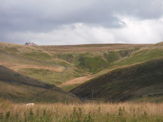
Backview from Stake Side across Goyt Valley up Goyt's Moss to Burbage Edge
SWC Walk 389 - Buxton to Macclesfield
Aug-21 • thomasgrabow on Flickr
swcwalks swcwalk389 banner 51374234175

Stake Farm and Shutlingsloe, from top of Stake Side
SWC Walk 389 - Buxton to Macclesfield
Aug-21 • thomasgrabow on Flickr
swcwalks swcwalk389 walkicon 51372469212
Backview from Torgate Hill up the Chest Hollow to The Cat & Fiddle
SWC Walk 389 - Buxton to Macclesfield
Aug-21 • thomasgrabow on Flickr
swcwalks swcwalk389 walkicon 51373229586
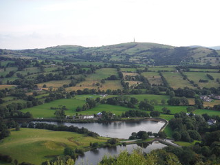
Teggsnose and Bottoms Reservoirs with Croker Hill, from Tegg's Nose
SWC Walk 389 - Buxton to Macclesfield
Aug-21 • thomasgrabow on Flickr
swcwalks swcwalk389 walkicon 51373230281

The Buxton Crescent Hotel
SWC Walk 389 - Buxton to Macclesfield
Aug-21 • thomasgrabow on Flickr
swcwalks swcwalk389 51373961304

St. Anne's Well, Buxton
SWC Walk 389 - Buxton to Macclesfield
Aug-21 • thomasgrabow on Flickr
swcwalks swcwalk389 51373459308

Gritstone Arm of River Wye, Pavilion Gardens, Buxton
SWC Walk 389 - Buxton to Macclesfield
Aug-21 • thomasgrabow on Flickr
swcwalks swcwalk389 51373961434
| Length |
24.9 km (15.5 mi), with 738/904m ascent/descent. For a shorter walk see below Walk Options. |
|---|---|
| Toughness |
8 out of 10, with 6 ½ hours walking time. |
| Walk Notes |
An exciting route from the fringes of the White Peak to the fringes of the Dark Peak, namely from the historic Spa Town of Buxton in Derbyshire to the historic Silk Town of Macclesfield in Cheshire. You leave Buxton along the gritstone arm of the Wye River through parks and the suburb of Burbage to rise steeply to the moorlands that form the British watershed between North Sea and Irish Sea, i.e.: between Wye and Goyt. Descend into the lonely Upper Goyt Valley and rise up again through woodlands and more empty moors to the ridge that forms the County Boundary with Cheshire.
The first half of the walk of the walk, once out of Buxton, is very lonely and exposed; in bad weather consider taking the bus to The Cat & Fiddle to cut out most of the moorland bits. |
| Walk Options |
Morning Shortcut - cut the out-and-back ascent of Shining Tor (cut 2.0 km and 75m ascent).
Bus Line 58 (Buxton – Macclesfield via Cat & Fiddle), with an hourly service Monday-Saturday and five buses on Sundays and Bank Holidays, offers various stops on - or close to - the route to either shorten the walk by cutting out a stretch at the start or by finishing the route early, and in any case of getting back faster from Macclesfield to Buxton than via the railway. Last return buses (as of 08/2021): Mon-Sat 18.45 Macclesfield Bus Station, 18.47 opposite Cundiff Close, Sun/Bank Holidays 17.45 Bus Station, 17.49 opposite Cundiff Close. See the route map for the location of the stops.
|
| Maps |
OS Explorer: 268 (Wilmslow, Macclesfield & Congleton) – just for the urban start – and OL24 (The Peak District – White Peak Area)
|
| Travel |
Buxton Station, map reference SK 059 737, is 22km southeast of Manchester, 299m above sea level and in Derbyshire. Macclesfield Station, map reference SJ 919 736, is 237 km northwest of Charing Cross, 133m above sea level and in Cheshire East. Buxton Station is the terminus of the Buxton Line from Manchester, with two trains per hour Mon-Sat daytime and one per hour else. Journey time is 60 mins from Manchester and ca. three hours from London (chg. at Stockport). Macclesfield Station is on the Stafford to Manchester branch line off the West Coast Main Line from London Euston (hourly service). Travel time to London is from 107 minutes Mon-Sat (longer on Sun). Saturday Walkers’ Club: The walk is doable as a daywalk from London with a train no later than 09.20 hours. |
| Elenvenses/Lunch |
Peak View Restaurant & Tea Room Buxton New Road, Macclesfield, Cheshire, SK11 0AR (01298 22103). The Peak View is located 11.1 km (6.9 mi) into the walk.
|
| Tea |
Tegg’s Nose Tea Room Tegg’s Nose Country Park, Buxton Old Road, Macclesfield, Cheshire, SK11 0AP (07955 532 703). The Tea Room is located 5.8 km (3.6 mi) from the end of the walk.
|
| Profile | |
|---|---|
| Help Us! |
After the walk, please leave a comment, it really helps. Thanks! You can also upload photos to the SWC Group on Flickr (upload your photos) and videos to Youtube. This walk's tags are: |
| By Train |
Out (not a train station) Back (not a train station) |
| By Car |
Start SK17 6AQ Map Directions Return to the start: Finish SK11 6JP Map Directions Travel to the start: |
| Amazon | |
| Help |
National Rail: 03457 48 49 50 • Traveline (bus times): 0871 200 22 33 (12p/min) • TFL (London) : 0343 222 1234 |
| Version |
Apr-24 Thomas G |
| Copyright | © Saturday Walkers Club. All Rights Reserved. No commercial use. No copying. No derivatives. Free with attribution for one time non-commercial use only. www.walkingclub.org.uk/site/license.shtml |


Walk Directions
Full directions for this walk are in a PDF file (link above) which you can print, or download on to a Kindle, tablet, or smartphone.
This is just the introduction. This walk's detailed directions are in a PDF available from wwww.walkingclub.org.uk