Castle Cary Circular via Camelot Walk
Along the fringes of the Somerset Levels over some fine viewpoints to three magnificent hills, one maybe the mythical Camelot of King Arthur fame

Cadbury Castle/Camelot, from The Beacon
SWC 392 - Castle Cary Circular via Camelot
Sep-21 • thomasgrabow on Flickr
swcwalks swcwalk392 banner 51583853541
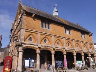
Market House, Castle Cary
SWC 392 - Castle Cary Circular via Camelot
Sep-21 • thomasgrabow on Flickr
swcwalks swcwalk392 walkicon 51583851071

Charwell Field and Corton and Parrock Hills, from SW corner of Cadbury Castle/Camelot
SWC 392 - Castle Cary Circular via Camelot
Sep-21 • thomasgrabow on Flickr
swcwalks swcwalk392 walkicon 51584518214

Windsor Lodge of Compton Castle, Compton Pauncefoot
SWC 392 - Castle Cary Circular via Camelot
Sep-21 • thomasgrabow on Flickr
swcwalks swcwalk392 walkicon 51584520064

View up High Street along Market House, Castle Cary
SWC 392 - Castle Cary Circular via Camelot
Sep-21 • thomasgrabow on Flickr
swcwalks swcwalk392 51583849311
| Length |
30.3 km (18.8 mi), with 602m ascent/descent. For a shorter walk see below Walk Options. |
|---|---|
| Toughness |
8 out of 10, with 7 hours walking time. For the whole outing, including trains, sights and meals, allow at least 11 hours. |
| Walk Notes |
This is a route along the fringes of the Somerset Levels over some fine viewpoints to three magnificent hills, one of which may well be the site of the mythical Camelot of King Arthur fame. You rise from the station up a hillock and through quiet residential streets to the centre of the charming market town of Castle Cary with many of its buildings built in the honey-coloured Cary stone, including the stunning Market House. Climb out of the modern-day town past the site of the medieval castle (only earthworks remain) to the top of Lodge Hill with its panoramic views across the Somerset Levels to Glastonbury Tor and the Mendip Hills, and inland towards the wooded boundary ridge with Wiltshire. Visible ahead already are the three hills at the far end of the walk route: Cadbury Hill, Parrock Hill and The Beacon/Corton Hill, each different in shape and appearance. You continue through a scenic dry green valley and along an ancient holloway, then through pastures in the shallow Cam River valley to lunch in North or South Cadbury, from where it’s only a short while to Cadbury Hill, the ‘likeliest contender’ for King Arthur's legendary court at Camelot.
|
| Walk Options |
Bus Line 1 (Yeovil – Shepton Mallet)connects South and North Cadbury, as well as Castle Cary’s Town Centre to the Railway Station. The bus runs Mon-Fri hourly in the morning from the station, but only once late lunch and once late afternoon to Castle Cary Station. On Saturday, there is only one bus in the morning, but it has more convenient times in the afternoon/evening than on weekdays.
|
| Maps |
OS Explorer: 142 (Shepton Mallet & Mendip Hills East) & 129 (Yeovil & Sherborne)
|
| Travel |
Castle Cary Station, map reference ST 635 335, is 39 km south of Bristol and 172 km south west of Charing Cross. It lies 46m above sea level and in South Somerset. It is on the Reading to Taunton and the Bristol to Weymouth (Heart of Wessex) lines, with a train from London roughly every hour (two-hourly on Sundays). Journey time from 82 minutes. Saturday Walkers’ Club: Castle Cary is outside the Network Southeast Railcard zone. Off-Peak returns for morning departures can be prohibitively expensive. Advance tickets are usually the better option. Take a train no later than 09.30. |
| Lunch |
The Catash Inn Cary Road, North Cadbury, Somerset, BA22 7DH (01963 441 531). The Catash is located 80m off route, 8.4 km/5.2 mi into the walk.
|
| Tea |
The Horsepond Inn The Triangle, Castle Cary, Somerset, BA7 7BD (01963 361 313). The Horsepond is located 1.8 km from the end of the walk. This pub is currently closed and for sale.
|
| Profile | |
|---|---|
| Help Us! |
After the walk, please leave a comment, it really helps. Thanks! You can also upload photos to the SWC Group on Flickr (upload your photos) and videos to Youtube. This walk's tags are: |
| By Train |
Out (not a train station) Back (not a train station) |
| By Car |
Start Map Directions |
| Amazon | |
| Help |
National Rail: 03457 48 49 50 • Traveline (bus times): 0871 200 22 33 (12p/min) • TFL (London) : 0343 222 1234 |
| Version |
Jul-22 Thomas G |
| Copyright | © Saturday Walkers Club. All Rights Reserved. No commercial use. No copying. No derivatives. Free with attribution for one time non-commercial use only. www.walkingclub.org.uk/site/license.shtml |


Walk Directions
Full directions for this walk are in a PDF file (link above) which you can print, or download on to a Kindle, tablet, or smartphone.
This is just the introduction. This walk's detailed directions are in a PDF available from wwww.walkingclub.org.uk