Castlemartin Range Coast Path walk
Easy cliff top path following the Pembrokeshire Coast Path through a MOD range, past dramatic cliffs, stacks, arches, a secluded chapel and 2 remote beaches. Check access times!

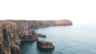
20180714_192347
Broad Haven and St Govan's Head
Jul-18 • Andrew Murphy on Flickr
swcwalks swcwalk317 43147833204

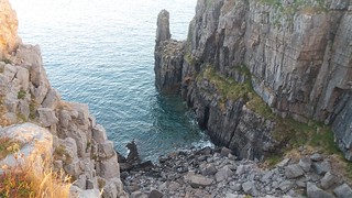
20180714_205421
Gulley containing St Govans chapel
Jul-18 • Andrew Murphy on Flickr
swcwalks swcwalk317 29995744338
20180714_205426
Gulley containing the chapel
Jul-18 • Andrew Murphy on Flickr
swcwalks swcwalk317 29995741598
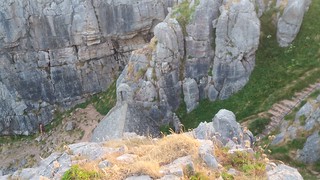
20180714_205438
Stairs down to St Govan's chapel
Jul-18 • Andrew Murphy on Flickr
swcwalks swcwalk317 43816893262
20180714_205443
Beach below St Govan's chapel
Jul-18 • Andrew Murphy on Flickr
swcwalks swcwalk317 29995736648

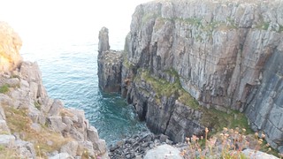
20180714_211811
St Govan's chapel hidden in a gulley
Jul-18 • Andrew Murphy on Flickr
swcwalks swcwalk317 43816890052
| Firing Range |
You can only do this walk when the firing range is open - usually weekends, some evenings, and the summer. See Castlemartin Range Firing Times Published mid-month for the month ahead. You need both parts open. The second part has more relaxed opening times than the first part. Reconfirm on the day if making a special journey - phone 01646 6622367 after 8:15 (recorded message). |
|---|---|
| Length | 8 miles (12.9 km) out and back. Half that if you car shuttle. Less if you turn back early. The distance correct - you don't need to hug the shoreline so much on the way back. |
| Toughness | 2 /10 (higher if optionally visiting the beaches - 1 of which involves scrambling) |
| OS Map | |
| Features |
This is an easy cliff top walk along a stunning and secluded stretch of the Pembrokeshire Coast Path, with dramtic cliffs, headlands, arches, stacks and hidden beaches. It passes the Green Bridge of Wales (a cliff arch), St Govan's Chapel (hidden in a gulley), and 2 remote beaches. The walk is through the "Range East" part of the Castlemartin MOD Firing Range. Access is free, but only possible on certain days. You must check in advance!. You must stick to the sea side of the coast walk (marked by white painted stones). Route finding is easy - just follow the coast! It is an out and back walk - don't worry, you'll be happy to do it twice! There are car parks at both ends if you want to shuttle. You can start from any of the 3 access points. The cliff top path is fairly level, and away from the edge (i.e., not scary). There are 3 beaches you can visit, 1 easy, 1 medium, 1 a bit of a scramble. There are several short diversions to headlands. |
| Walk Options |
You could make this a circular walk following the "Castlemartin Range Walk", an always open permissive path maintained by the army around the range boundary. Its waymarked with a tank symbol. Then, follow the Green Bridge / Stack Rocks access road to get back to your car. Far nicer to walk back along the coast! Note also that as the path is not a public footpath, the 'no bulls in the field' rules do not apply |
| Range West |
Castlemartin has been a firing range since WW2. It is untouched by modern argriculture, so of great scientific interest for its flora and fauna, and is effectively a nature reserve. It is a major firing range, used about 40 weeks a year by NATO countries for training with live rounds from artillary, tanks, and anti-aircraft weapons. The firing range is split into 2 parts, 'range east' and 'range west', by the 'stack rocks/green bridge' access road. This walk is in range east only, which is regularly open to the general public. The range west coast path is, if anything more remote, and more spectacular, however this part of the firing range is never open to the general public (due to unexploded shells). Access is only possible on guided walks (about 1 a month) by either the National Park Authority or the local Ramblers group.
Note that there are differant arangements for anglers, cavers, climbers, and surfers, in recognised groups, who can get an annual permit after attending a safety briefing. |
| Travel |
The Green Bridge of Wales / Stack Rocks, SA71 5EB [*], and St Govans, SA71 5DR [*], have free MOD car parks. Broadhaven (beach), SA71 5DR [**], and Bosherton (Lily Ponds, slightly inland), SA71 5DN, have NT car parks ( £5 / £2 after 2pm / free to members / free 8 Nov to 14 Mar / tickets valid at all NT Pembrokeshire car parks). There is limited on street parking in Bosherton village by the pub Postcodes are of [*] the start of the range acces road, or of [**] the hamlet. Follow road signs (or Google Maps) for the last km. The Coastal Cruiser Bus 387/388. Summer (Jun-Sep): daily, ~ 2/day. Oct-May: Thur and Sat only. Has a circular route: Pembroke Dock station - Bosherton (lily ponds) - Broad Havan (NT car park) - St Govan's car park - Green Bridge (Stack Rocks ) car park - past Range West - Angle - Pembroke Station. You could use this bus to walk 'one way'. Large groups should phone ahead to reserve space on 01437 764551. Check the timetable! - tourist bus routes change frequently due to available funding. |
| Links |
Castlemartin has been a firing range since WW2. As such its is untouched by modern argriculture, so of great scientific interest. |
| Profile | |
|---|---|
| Help Us! |
After the walk, please leave a comment, it really helps. Thanks! You can also upload photos to the SWC Group on Flickr (upload your photos) and videos to Youtube. This walk's tags are: |
| By Car |
Start Green Bridge / Stack Rocks, Castlemartin Range, near Merrion, Pembrokeshire, SA71 5EB Map Directions |
| Amazon | |
| Help |
National Rail: 03457 48 49 50 • Traveline (bus times): 0871 200 22 33 (12p/min) • TFL (London) : 0343 222 1234 |
| Version |
Apr-24 Andrew |
| Copyright | © Saturday Walkers Club. All Rights Reserved. No commercial use. No copying. No derivatives. Free with attribution for one time non-commercial use only. www.walkingclub.org.uk/site/license.shtml |

Walk Directions
Stack Rocks to St Govans
The 'Road leading to Stack Rocks' must be open to do this part of the walk - see the MOD firing times link.
The Green Bridge of Wales access road is near Merrion on the B4139. Drive to the free car park at the end.
- From the car park (Stack Rocks on the OS map), head down to the green bridge (a cliff arch with grass on the top).
- Follow the coast path east - its broad, almost flat, alongside the cliff edge, with dramatic views throughout.
- In 0.5km, you reach Flimstone Bay, a small sandy cove surrounded by cliffs, with a small stack in the center. Access is a light scramble via a steep path in at the NW corner of the cove.
- In 1km, you reach Bullswater Bay, another small sandy cover surrounded by steep cliffs. Steep but OK. There are arches and caves - great for photography. The path down is at the NE corner. Steep but OK.
- In 1km, pass Mewsford Point.
- In 1.5km, pass the 'The Castle' (a rock formation)
- In 400m, you reach Saddle Head.
- In 1km you come to St Govan's Chapel car park.
St Govans to Broadhaven Bay
The 'Road from Bosherton to St Govans' must be open to do this part of the walk - see the MOD firing times link.
If starting here, drive to the St Govan's car park along the access road from Bosherton.
- Head down into the steep gulley to visit St Govan's Chapel chapel (stairs). You can walk through the small chapel to carry on down to the water's edge (light scramble)
- In 400m detour of to the right to St Govan's Head (500m there, 500m back).
- In 400m, pass the access path (easy) to New Quay, a sandy beach in a long narrow inlet
- In 800m come the the range boundary. Just below are 2 small coves with steep (scrambling) paths down
- In 400m, you come to the Broad Haven (NT) car park, overlooking the large and spectacular Broad Haven sandy beach.
Options to continue the walk
In order!
- At the head of the beach (below the steep grassy cliff/hill), is the start of the Bosherton Lilly Ponds path (NT, free entry). Follow the waymarked path along the west side of the lake to the Bosherton Lilly Ponds (NT) car park, and the village pub. Return along the east side of the lake. Amazing when the lillies are flowering.
- Its 4km (3 if you skip Stackpole Head) further along the coast path to the stunning Barafundle Bay. Return the same way. Spectacular!
- Walk back to your car along the coast.
- Make a loop by following the Wales Coast path inland along the range permimiter road. However, walking back along the coast is better.