North Downs Way: Caterham to Knockholt walk
The North Downs Way through woods with fine views - and within Zone 6 (some road noise). Long, with shorter options. Return by bus.

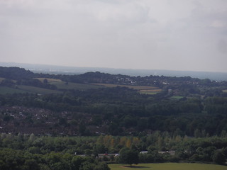
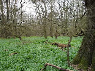
Park Wood, Bench and View on North Downs Way
SWC Walk 111 Caterham to Knockholt (North Downs Way)
Aug-16 • thomasgrabow on Flickr
swcwalks swcwalk111 walkicon banner 28715844513
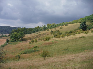
Greensand Ridge and South Downs
SWC Walk 111 Caterham to Knockholt (North Downs Way)
Aug-16 • thomasgrabow on Flickr
swcwalks swcwalk111 walkicon 29049578820
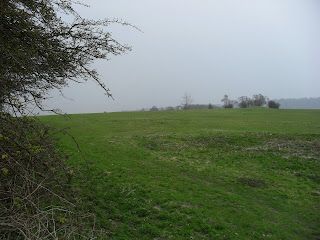
Slope and Beech Plantation near Titsey Plantation
SWC Walk 111 Caterham to Knockholt (North Downs Way)
Aug-16 • thomasgrabow on Flickr
swcwalks swcwalk111 walkicon 28713860934

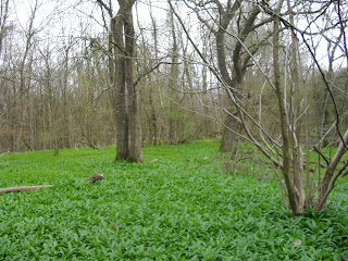
M25 and North Downs, from edge of Titsey Plantation
SWC Walk 111 Caterham to Knockholt (North Downs Way)
Aug-16 • thomasgrabow on Flickr
swcwalks swcwalk111 walkicon 29303454226
| Length | 26.2 km (16.3 miles) with shorter options of 13.0, 15.5, 22.0 km (about 7, 10, 14 miles) |
|---|---|
| Toughness | 7.5 out of 10. Well waymarked paths, but several steep climbs in the morning. Parts can be slippery after prolonged rain. |
| Features |
This walk follows a section of the North Downs Way (NDW) south east of London, along the edge of the North Downs Escapement. The walk is very rural despite starting and finishing in "Zone 6". It has fine views to the south, and some pretty woods. However, the early part of the walk suffers from some noise from the M25. There are several ways to cut the walk short, returning by bus (covered by Oyster). The walk starts in Caterham (a commuter town on the edge of Zone 6) and heads south along a ridge to join the North Downs Way (NDW). The main part of this walk then follows the NDW along the edge of the North Downs escarpment, through pretty woods carpeted with wild garlic and bluebells and clearings with nice views to the south. There is a slight diversion from the NDW through the Titsey Plantation. The morning of the walk is quite strenuous as the path meanders up and down the side of the North Downs escarpment. After passing Titsey, the M25 is left behind, and the walk is quiet. Lunch is at a pub on the summit of Botley Hill (268m), a Marilyn and the highest point on the North Downs. Note the true summit is by a water tower/radio mast, about 1 km west of the trig point. The afternoon section continues along the NDW, through more open land and field, with views to the south Finally, leaving the NDW, it heads north to the village of Knockholt Pound (and its nice pubs) and on towards Knockholt Station. The start and end of the walk are inside Zone 6 - so you can use a 1 day Travelcard. There are also places where you can cut the walk short by using regular buses on which you take Oyster / 1 day Travelcards, making this walk suitable for both summer and winter. On Sunday, buses are less frequent, but the lunchtime pub (a music venue) often has free live music, and it's only a few km further to Westerham Hill Road's bus stop. |
| Walk Options |
After following the NDW as far as Botley Hill, there are some shorter options:
|
| Travel |
All these options are covered by an Oyster/Zone 1-6 Travelcard (bus details updated Feb-20)
|
| Links |
|
| Lunch |
|
| Tea |
Knockholt Pound. (3.5 km from the end)
Halstead (1.8 km from the end)
|
| Author's Note |
The NDW follows the crest of the ridge, except at 1 point near the start. Between Gangers Hill and Titsey (below a quarry marked on the OS Explorer map), it descends to the bottom of the ridge, and remains close to the M25 for about 1km. I explored an alternative route, staying at the top of the ridge. It didn't work. First you follow The Ridge, a road (with pavement), but views to the south blocked by luxury houses. Just after the 'Woldingham Viewpoint' car park you could follow a road downhill, and then pick up the Titsey estate permissive path. The ridge top road continues (wrongly marked Woldingham Road on OS Explorer) passing above the Titsey plantation with no pavement, and no paths through it's woods (that I could find), i.e. a grim 3km of road walking. Stick to the NDW route!. [Nov-21] |
| North Downs Way |
This walk is a stage of the North Downs Way - a 125 / 131 mile national long distance path - that follows the North Downs ridge in South East England. |
|---|---|
| Profile | |
| Help Us! |
After the walk, please leave a comment, it really helps. Thanks! You can also upload photos to the SWC Group on Flickr (upload your photos) and videos to Youtube. This walk's tags are: |
| By Train |
Out (not a train station) Back (not a train station) |
| By Car |
Start CR3 6LB Map Directions Return to the start: Finish TN14 7HR Map Directions Travel to the start: |
| Map Walk | This walk requires an OS map and a compass or GPS for navigation. You can print out OS maps using the link above. |
| Amazon | |
| Help |
National Rail: 03457 48 49 50 • Traveline (bus times): 0871 200 22 33 (12p/min) • TFL (London) : 0343 222 1234 |
| Version |
Apr-24 Andrew |
| Copyright | © Saturday Walkers Club. All Rights Reserved. No commercial use. No copying. No derivatives. Free with attribution for one time non-commercial use only. www.walkingclub.org.uk/site/license.shtml |


Walk Directions
Caterham to the NDW (3.4 km)
- Turn left out of Caterham Station, and walk past some shops (Waitrose, Morrisons etc.) for 50m.
- Turn right at the mini roundabout, and then after 20m, by Cafe Nero, turn left along Timber Hill Road.
- At the end of the road, go straight on, along a footpath which climbs steeply.
- Cross the busy A22 - there is a median, carry on uphill, and turn left uphill a tarmac track.
- Turn right at an automated car barrier this side of some new housing on the grounds of the former Tillingdown Farm and head south along a car wide gravel track, a signposted public footpath.
- The track initially runs between fences, while it turns left and then right to the side of the estate, then between hedgerows.
- After 1 km, the path turns left at a T-junction along a car wide farm track along a high metal fence around a small industrial estate (Paddock Barn on the OS map).
- Turn right with the fence and at the next fence corner, continue southerly, now over open pastureland.
- In 370m, the path enters woods over a stile in a barbed wire fence on a bearing of 135 degrees, and starts to descend along a wide sunken path (this may be part-blocked by fallen trees).
- In 90m turn right by a marker post just inside the wood at a T-junction of footpaths. In 35m veer left by another marker post to exit from the wood onto the border of a large sloping arable field.
- The onwards route of the NDW is visible at the bottom of the field, but there is no right-of-way down to it. Instead, turn right to cut the field corner (230°) and in 100m re-enter the wood and go over a stile in a fence.
- In 100m you start to descend along a stepped path which eventually turns left and joins the NDW on a car wide concrete farm track by a four-way signpost, where you turn left (east).
NDW: Winders Hill to Botley Hill (6.8 km)
- After 400m pass a building which you saw from the top of the sloping field, turn right on a small road, then immediately left on a signposted footpath. Continue through woods carpeted with wild garlic in season.
- Continue along the well signposted NDW. In 750m you cross a lane and continue through a wood with the M25 down below on the right. The path then gently descends through the wood and at the bottom you turn left through a metal kissing gate at a junction with a tarmac lane and follow the path uphill to the left of the lane. In 470m join the lane, just before a T-junction with a road, and turn right along the road.
- In 80m veer right at a three-way signpost (one sign is broken at time of writing) along a gravel-and-earth path through a wood (i.e. ignore the hard right turn as well as a left turn). In 330m the path turns to the right and then to the left again.
- In another 270m, at the end of Gangers Hill, the path turns steeply downhill towards the M25 motorway along a stepped path (good views ahead of the Oxted line emerging from a tunnel) to turn left just after passing a viewpoint.
- In 570m turn right through a metal kissing gate and go downhill along a fenced quarry on the left, with an arable field on the right. In 250m turn left with the fence and another field on the right. 50m before the end of the field go through a metal kissing gate and along a fenced path. In 50m turn right along a tarmac lane.
- In 40m turn left up some steps and bear left uphill and in 30m walk through a metal kissing gate into a grassy slope by a National Trust Oxted Downs sign. Continue uphill with the left hand boundary and in about 100m turn right at a three-way signpost by a bench.
- About 400m further on, 30m before a field corner with a metal kissing gate leading to the Titsey Plantation, the recommended route briefly leaves the NDW: turn left steeply uphill along a clear permissive path up the grassy slope. (If you take the NDW route: Titsey Place has a nice tea room [open Wed and Weekends in summer], but it is 1.5 km off-route).
- In 120m turn right through a fence gap (a missing stile) into the plantation. In 20m a railed stepped path joins from the right below. Turn left uphill, immediately forking left by a bench on the left along the upper of two wide tracks (60°).
- The permissive route and the official NDW merge on the way up to the summit of Botley Hill (a Marilyn). At the summit, there is a road junction, and a small car park.
- Head NW for 300m along a shared cycle- and footpath to the side of the A269 to Botley Hill Farm (the lunchtime pub).
NDW: Botley Hill to Tatsfield, Westerham Hill Road (5.0 km)
- From Botley Hill Farm, return to the small car park at the top of the wood, and turn left along the lower road (signed 'Limpsfield, Edenbridge'), and then pick up a path on the left (which parallels the road for a while). In 650m turn up left away from the road up some steps and turn right at the top of the steps.
- In 200m cross White Lane a little to the right and in another 250m emerge from the wood to follow a clear path through a sloping pasture, veering up to the left. In 370m, just below the top of a field, 50m below a road, the NDW continues east.
- To finish at Tatsfield, leave the field in the top corner and cross the road (leaving the NDW), and continue north for 1 km to Tatsfield (pub, bus to New Addington).
- Turn right through a metal kissing gate to carry on along the NDW. You go though a wooden kissing gate into another pasture and eventually leave it by turning left through a wooden kissing gate and up a stepped path.
- Cross a road at a four-way junction. Turn right and follow a lane (Chestnut Avenue), eventually with some large houses on either side. In 1.0 km you come to a T-junction with a tarmac lane.
- Head north (leaving the NDW), then east along a track towards Hawley's Corner, if you wish to cut the walk short.
- Turn right to continue south then east along the signposted NDW, initially on tarmac, later gravel. In 1.5 km you reach Westerham Hill road (the A233). To your right is a bus stop 100m away.
NDW: Westerham Hill Road to Knockholt Pound (7.0 km)
- This stage is through open fields, a little below the crest of the North Downs, with views throughout. A minor road runs parallel, just over the crest, the whole way. If the fields are too muddy in winter, take any path north for approximately 300m to the road, then turn right (east), and follow the road (Grays Road, then Main Road) passing the (closed) Tally Ho pub, St Katherine's Church in Knockholt Village, to reach the Three Horseshoes pub as below.
- Carry on along the NDW: Cross the road and walk through a hedge gap and down some steps to turn up left along a field boundary. In the field corner in 250m walk through a metal kissing gate to continue in the same direction through trees. In 100m turn right at a T-junction and in 230m you emerge from the trees and continue in the same direction.
- In 150m turn left up a stepped path through trees and in 70m walk through a metal kissing gate to continue in the same direction up through a field, from which you enter trees again in another 120m through a metal kissing gate. Follow the NDW to the right and continue easterly for a further 5.5 km, in the process bypassing the out-of-sight Knockholt village (its pub has long closed).
- In more detail: In 50m turn rigth at a T-junction with a track and in 80m go through a metal kissing gate into a pasture and follow its left-hand boundary. In 350m go through a metal kissing gate into a wood and in 60m leave it through gap into an arable field and continue along the left-hand boundary.
- In 90m turn right with the boundary and in 200m ignore a left turning footpath. In 60m go through a ste of metal kissing gates into the next field and in 140m turn left out of it onto a track between trees and turn right along it. In 140m continue ahead through a wooden kissing gate where the track turns to the right.
- In 200m go through a woodne kissing gate into a pasture and [!] turn right along its boundary. In 140m turn left in teh field corner, with a wood on the right, and in in 220m enter the next field through a metal gate and follow its right-hand boundary.
- In 140m go through a couple of wooden kissing gates either side of a tarmac lane and in 320m do the same again. Go through three fields along thjeir left-hand boundaries with wooden kissing gates inbetween and from the third field, with a road just to the left at a bend, go through a wooden kissing gate and a wooded belt and then follow an arable field's right-hand boundary.
- In 480m go through a gap into the next arable field and in 150m turn left with a marker post in its corner. In 160m turn right with a marker post into the next field and follow it right-hand boundary. In 220m turn left in its far corner with a hidden marker post.
- In 100m turn right with a signpost (Knockholt Pound 1 1/4) to cross a road and go through a metal kissing gate opposite. Follow a right-hand field boundary. In 160m enter a wood and leave it into another field. [!] Turn right along its boundary and in 90m enter the next field through a gap.
- In 40m curve to the left with the boundary and in 350m go through a wooden gate into the next field, by a bench on the right and fien views through a break in the trees into the valley to Chevening House, country residence of the Foreign Secretary.
- In 110m go through a metal kissing gate into teh next field and in 470m you walk through a metal kissing gate onto a tarmac lane at a T-junction.
- Leave the NDW, by heading north (left) along the lane, signposted 'Knockholt Pound 1/4 mile' (two pubs, bus stop). In the village find The Three Horseshoes on your left at a main junction and The Harrow Inn 250m to your right along the road.
Knockholt Pound to Knockholt Station (3.8 km)
- Head north east along a lane towards Halstead for 1 km (initially Main Road, later - at a fork - becomes Halstead Lane [ignore left fork]). This is mostly without pavement or walkable margin until you get to Halstead. After 250m with pavement, more or less in the middle of the village, by the left turning Southdene Road, you have a choice.
- Direct Route: Turn left on Southdene Road. At the end, turn right through a wooden kissing gate along a public footpath (north). In 350m ignore a stile on the right but in another 100m, turn right over a stile and follow a hedge on the left to a road, then turn left along Church Road.
- Via the pubs: Continue along the road into Halstead. At a crossroads, ahead is The Cock Inn, to the right the Rose and Crown. After the pubs, go left on Church Road for 500m.
- Just before a church, turn right across the road and through a gap in a hedge (signposted 'Knockholt Station 1 mile') and follow a path along a couple of pastures.
- In 280m you enter a former golf course slated for a housing development. Continue in the same direction along a fenced path. Eventually you pass the ex-golf club car park on your left.
- Go through a hedge gap and turn left with the fenced path, then turn right (north again) with it to descend a hill and reach a road. You can see the train station approach 60m away to your left.