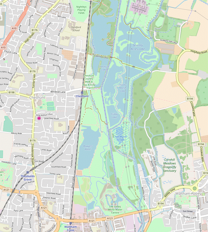
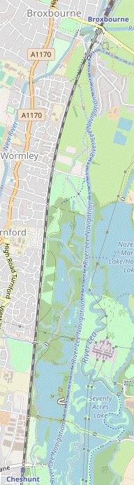
Cheshunt to Broxbourne walk
River Lee Country Park and Waltham Abbey.


| Length |
Main Walk: 17½ km (10.9 miles). Three hours 45 minutes walking time. For the whole excursion including trains, sights and meals, allow at least 7½ hours. Short Circular Walk, from Cheshunt: 12 km (7.5 miles). Two hours 30 minutes walking time. Long Circular Walk, from Broxbourne: 20 km (12.4 miles). Four hours 20 minutes walking time. |
|---|---|
| OS Map |
Explorer 174. Cheshunt, map reference TL365022, is in Hertfordshire, 7 km NE of Enfield. Waltham Abbey is in Essex. |
| Toughness |
1 out of 10 (2 for the Long Circular Walk). |
| Features |
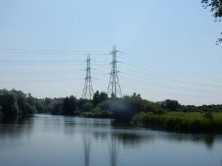
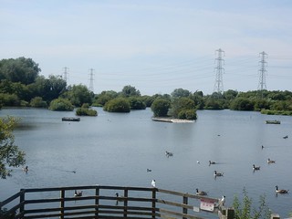
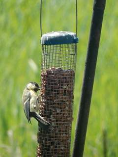
The Lea Valley is a wide floodplain which has long been both an important transport corridor and a natural boundary (eg. between the Saxons and the Danes in the Dark Ages). Its rivers provided water and power for many mills and factories, although nowadays the journey out of London seems to offer an unbroken line of light industrial estates, warehouses and retail parks. This does not exactly lift the spirits when seen from the train, but on the Herts / Essex border just before Cheshunt the view abruptly changes to the tree-lined lakes of River Lee Country Park. There are good opportunities for bird-watching in this wetland landscape of rivers and filled-in gravel pits, and several locations where orchids can be seen in late May and June. A series of sculptures are dotted around the park and the walk route goes past many of them. The lunch stop is in the historic market town of Waltham Abbey. In about 1030 a black crucifix was brought to the town and one of the pilgrims attracted by this ‘Holy Cross’ was Harold Godwinson, then Earl of Essex and later (briefly) King Harold Ⅱ in 1066. He built a larger stone church on the site and this in turn was rebuilt in Norman style after the Conquest. It was extended again in the 12thC when Waltham Abbey was built by Henry Ⅱ as part of his penance after the murder of Thomas Becket. It was the last monastic house to be closed by Henry Ⅷ in the Dissolution of the Monasteries and most of the abbey was demolished in 1540. Fortunately, part of its medieval nave survived to become the present Church of the Holy Cross: reminiscent of a scaled-down Durham Cathedral, it is well worth a visit. The walk route goes back past Cheshunt station so it is possible to complete a Short Circular Walk. The full Main Walk continues to head north through a less-frequented section of the Country Park, at first on woodland and lakeside paths following the course of the Small River Lea and then on the River Lee Navigation's towpath. An optional stretch through a water meadow leads into the Broxbourne Waterside area, a centre for boating and canoeing with a café and a pub for refreshment before the journey home. |
| Walk Options |
As well as the Short Circular Walk from Cheshunt, directions are given for a Long Circular Walk from Broxbourne station. For the most part this takes a different route out through the Country Park, but there is a 600m stretch of towpath where there is no convenient alternative. On all the walk options you could omit the loop into Waltham Abbey. This Short Cut is worth considering if you prefer a walk entirely within the Country Park, but of course it leaves out the walk's historic features as well as the town's wide choice of eateries. On the full walk a suggested loop around Waltham Abbey is described, with an optional extension around a large water meadow to the north of the town. If you miss a train and start a group walk late you might be able to catch up by taking an early short cut at Seventy Acres Lake, saving 1¾ km. Conversely, there are several places where you can extend the walk by detouring to bird hides and other points of interest mentioned in the directions. If you want to abandon the walk in Waltham Abbey you could head for the station at Waltham Cross; this is 1½ km away along a busy main road, but several bus routes go there from the large roundabout on Highbridge Street (and also to places where you could catch a tube, eg. Loughton). |
| Transport |
Cheshunt and Broxbourne are served by trains from Liverpool Street (and Stratford) on the Greater Anglia line to Cambridge, Bishop's Stortford and Hertford East. The normal off-peak service is six trains per hour (four on Sundays), with a journey time of 20-28 minutes to Cheshunt. All trains call at Tottenham Hale, on the Victoria line. There is also a (slower) half-hourly London Overground service from Liverpool Street to Cheshunt, via Seven Sisters. Oyster PAYG can be used at both stations but a simple return to Broxbourne (or Cheshunt for the Short Circular Walk) might be better value. Cheshunt is in TfL Zone 8 but Broxbourne is outside the numbered zones. A London Freedom Pass is only valid for travel to Cheshunt on the London Overground service from Liverpool Street, not on the Greater Anglia line. |
| Suggested Train |
Take the train nearest to 10:30 from Liverpool Street (or Stratford) to Cheshunt. For the Long Circular Walk, take the train nearest to 10:00 to Broxbourne. On all the walk options, you could start at least half an hour later if taking the Short Cut omitting Waltham Abbey. |
| Train Times |
|
| Timetables |
|
| River Levels |
|
| Lunch |
There are plenty of refreshment places in Waltham Abbey (7¼ km from Cheshunt; 9¾ km from Broxbourne), although the pubs are not particularly food-oriented and fast-food joints are the predominant alternative. The suggested place for a pub lunch is The Crown (01992-732590) in Romeland, which has a small courtyard garden. An alternative is The Angel (01992-718671) at the far end of Sun Street; in between these two The Sun and the Welsh Harp appear to be permanently closed. For a light lunch the Gatehouse Café near the church entrance looks the most appealing of the cafés in the town centre. An earlier lunch is possible at the Brew Street Kitchen and Bar in the Lee Valley White Water Centre (03000-030616), which is also the only refreshment place on the Short Cut route. Although primarily serving visitors taking part in the activities, this modern food outlet declares that it is “open to everyone, from rafters to ramblers”. It has plenty of indoor and outdoor seating and is open daily to at least 4pm weekdays, 5pm weekends. |
| Tea |
The Brew Street Kitchen and Bar in the White Water Centre (see above) is a good place to stop for mid-afternoon refreshment, especially if you spend some extra time in and around Waltham Abbey after lunch (or are doing one of the shorter options as an afternoon walk). At the end of the Short Circular Walk there are several establishments near Cheshunt station, although these seem to cater mainly for thirsty commuters on their way home. There is a Latte to Go buffet on Platform 2, but this usually closes “between 2 & 3pm” at weekends. Just past the station there are two pubs on Windmill Lane, The Red Cow (01992-623509) and The Maltsters (01992-631369), plus the small Rose Café. There are more places in the town centre but this is 750m past the station. Towards the end of the longer walk options the Old Mill Retreat Café (01992-460960; open daily to 4pm winter, 5.30pm summer) serves home-made cakes in a pleasant spot on Broxbourne Waterside. Nearby, The Crown (01992-462244) is part of the Vintage Inns chain and has a large riverside garden. There are also some snack bars on the covered walkway to the station platforms, but for other places you would have to detour to the town's High Street, 400m off the walk route. |
| Profile | |
|---|---|
| Help Us! |
After the walk, please leave a comment, it really helps. Thanks! You can also upload photos to the SWC Group on Flickr (upload your photos) and videos to Youtube. This walk's tags are: |
| By Train |
Out (not a train station) Back (not a train station) |
| By Car |
Start EN8 9AQ Map Directions Return to the start: Finish EN10 7AW Map Directions Travel to the start: |
| Amazon | |
| Help |
National Rail: 03457 48 49 50 • Traveline (bus times): 0871 200 22 33 (12p/min) • TFL (London) : 0343 222 1234 |
| Version |
Apr-24 Sean |
| Copyright | © Saturday Walkers Club. All Rights Reserved. No commercial use. No copying. No derivatives. Free with attribution for one time non-commercial use only. www.walkingclub.org.uk/site/license.shtml |

Walk Directions
Click the heading below to show/hide the walk route for the selected option(s).


 Walk Maps
©
Walk Options (
W/A )
Click on any option to show only the sections making up that route, or the heading above to show all sections.
- Main Walk (17½ km)
Walk Directions
Click on any section heading to switch between detailed directions and an outline, or the heading above to switch all sections.
If you are doing the Long Circular Walk (from Broxbourne), start at §C.
- Cheshunt Station to Seventy Acres Lake (1¼ km)
- Cross the railway line and turn left into River Lee Country Park, taking the right-hand path at the back of the car park. At the far end turn right to go between Cheshunt Lake and North Metropolitan Pit, then turn left on this side of the River Lee Navigation. After passing an Orchid Area (which you could loop through) cross the navigation at Cheshunt Lock to come to Seventy Acres Lake.
- Arriving from London, leave the station near the front of the train and turn right to cross the railway tracks, via the footbridge if necessary. On the other side immediately turn left into the signposted River Lee Country Park?, with the first of several information panels for the Waterbird Discovery Trail at the back of the small car park. Take the right-hand path through this semi-open area.
- The surfaced path goes past a series of small wooden structures (for exercising your dog!) with a stream on the right, the Small River Lea?. Later Cheshunt Lake is visible beyond the stream. At the end turn right to cross the stream and follow the track between two lakes, with the one on the left having the less appealing name of North Metropolitan Pit.
-
Just before the track rises to cross the River Lee Navigation? fork left onto a path running parallel to its towpath. You will be crossing the navigation at the lock 300m ahead, but shortly before reaching it there is a gate on the left into a fenced-off area of wet woodland.
- If you wish you can detour around this North Met Pit Orchid Area on a continuous section of boardwalk (part of the Orchid Discovery Trail), returning to the main path a little way ahead.
- Either way, immediately after the exit from the Orchid Area fork right off the main path onto a broad grassy path going up to Cheshunt Lock. Cross the navigation and follow the path out to another Waterbird information panel in front of Seventy Acres Lake.
- Seventy Acres Lake to Hooks Marsh Lake (2¼ • ½ km)
-
For the main route turn left and go around the lake, later with the Old River Lea on your left and passing the Bittern Information Centre. Take the right-hand path at the back of Hooks Marsh car park to go across a footbridge between two lakes, then turn left onto a path between Hooks Marsh Lake and Police Pit.
- Alternatively, turn right and take the direct route to Hooks Marsh Lake.
-
Main route (2¼ km)
- For the loop around the lake turn left onto the perimeter path, heading N. Follow the path around the north-western corner of the lake and then fork right at a triangular path junction to start coming back on the other side.
-
The path follows the meandering course of the Old River Lea? on the left, passes an “Otters in the Lee Valley” information panel and comes to a low brick building on the right, the Bittern Information Centre.
There is a bird hide which you can use even if the centre is closed, although you will be lucky to see a bittern (a very secretive heron).
- Continue around the lake, passing a viewing platform down on the shore and a footbridge across the river on the left. The path makes a wide loop around an island in a meander of the river and eventually leads into a car park, now with the wide Flood Relief Channel on your left.
- Go through the car park and fork right in front of a Bird Transition sculpture, away from the river. Follow the path out of the car park and over a high footbridge between two lakes. Shortly before the path curves right turn left onto an unsurfaced path heading S.
-
Short cut (½ km)
- Head S on the perimeter path, with the lake on your left. In 300m fork left at a path junction with a Viking Sign Post sculpture, away from a bridge over the navigation.
- After curving right and then left, and where you can see the path sloping up towards a high footbridge 100m ahead, turn right onto an unsurfaced path heading S.
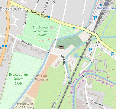
- Broxbourne Station to Silvermeade (¾ km)
- From the station go up an embankment and turn left onto the New River Path. Follow this across the B194 and past the parish church to Mill Lane. Turn left and go down this lane, continuing on a path under the railway to the towpath of the River Lea.
- Outside the station go through a gate on the right and climb a flight of steps up an embankment. At the top turn left onto a path alongside the New River?, passing the station car park down on your left. At the far end go through a kissing gate and turn right onto Station Road, crossing the river.
- Cross the road carefully and in 50m turn half-left onto a path across a corner of Broxbourne Recreation Ground, with a churchyard beyond the river on your left. At the end turn left onto a lane (Churchfields) to go back across the river and past St Augustine's church?. At a junction follow the road down to the left, away from the river.
-
The road (now Mill Lane) curves to the right. Keep right at junctions, entering River Lee Country Park?. The lane goes alongside the River Lea?, passing a Canoe & Cycle Hire shed and the Old Mill Retreat Café, with a signposted path for a “Wetlands and Woodlands” trail between them.
The café is the suggested tea place at the end of the walk, with the trail an optional extension.
- Continue on the riverside path, under a low railway bridge. The path merges with another from a footbridge on the left where the river merges with the River Lee Navigation?. At the start of this section of its towpath there is a gate on the right with an information panel for Silvermeade?.
- Silvermeade to Wharf Road (1¼ km)
- The suggested route is to go through a water meadow (Silvermeade) on the right before rejoining the towpath for the final 600m to Wharf Road car park. Alternatively, simply follow the towpath all the way to the car park.
-
If the ground is not waterlogged, the suggested route is to go through the gate into the water meadow.
- If instead you decide to stay on the towpath, resume the directions at [?] (after 650m, where the main route rejoins from the second of two more gates into the meadow).
- Inside the meadow follow a grassy path curving gently to the left. You will be leaving this triangular part of the meadow at its far right-hand end, but the path goes along its left-hand side (close to the towpath), then swings right in front of a belt of trees. Cross a stream in these trees on a wide bridge and go through a wooden kissing gate into a larger part of the meadow.
- Ignore a footbridge across the reed-covered stream on the right and bear slightly left to follow a faint grassy path parallel to the stream for 400m. You pass several small fenced-off areas and another footbridge on the right. The path gradually approaches the river and eventually you go out through a kissing gate and turn right onto the towpath.
- After the exit from Silvermeade there is a 600m stretch along the towpath, with the river bending left and then making a long slow curve back to the right. 100m after going past vehicle barriers veer right off the towpath into Wharf Road car park.
- Wharf Road to Turnford Brook (2¼ km)
- Leave the towpath and take a surfaced path heading south and then south-west for 400m, crossing a lane along the way. Bear left onto a cycle path and follow this southwards for 1¾ km, across Slipe Lane and then between two large fishing lakes and the railway line. Turn left at a path T-junction in front of Turnford Brook.
-
Leave the car park on a surfaced path heading S across a grassy picnic area, dotted with trees. This soon merges with another path from the river and bears right. In 150m you cross a ditch on a footbridge and turn left briefly onto a lane, then veer right onto the continuation of the path. In 200m bear left at a path junction to head S again.
The suggested route now simply follows this cycle path for 1¾ km as it weaves between the railway line off to your right and two large fishing lakes. Some grassy paths nearer the railway are slightly more direct, but these have no view of the lakes.
- In 50m keep ahead at a path crossing. The path soon passes Railway Pit lake on the left, then bends right to head towards the railway. After a stretch alongside the tracks it swings left and right, then goes alongside the much larger Ashley Lake for nearly 500m.
- At the end of this lake the path turns half-right and heads back towards the railway. After a final stretch of 200m near the tracks you come to a path T-junction in front of a stream, Turnford Brook. Turn left to head E, away from a bridge over the railway.
- Turnford Brook to Hooks Marsh Lake (1¾ km)
- Cross the Small River Lea and fork left, then veer right to head eastwards. Cross over the Lee Navigation and turn right at a path T-junction in front of the Old River Lea. In 250m fork right onto a path going around the western side of Seventy Acres Lake. In its south-western corner turn left to continue briefly around the lake, then turn right onto a path between Hooks Marsh Lake and Police Pit.
- In 100m the path crosses the Small River Lea (little more than a ditch here) and you fork left, briefly heading back towards Broxbourne. Keep to the main path as it veers right and goes between the tree-lined edges of two lakes. Go up to and straight across the Lee Navigation on a high bridge.
- Continue across Holyfield Marsh to a path T-junction flanked by a pair of Wildlife Bench sculptures. Turn right to head S alongside the River Lea, with a large electricity substation on the opposite bank. In 250m fork right at a triangular path junction, away from the river.
- The path soon swings left to go alongside the large Seventy Acres Lake, with the navigation behind trees on your right. In 350m keep ahead where a path from Cheshunt Lock joins from the right, by an information panel for the Waterbird Discovery Trail.
- …
- …
- Hooks Marsh Lake to the White Water Centre (2½ km)
- Go all the way along the path between the two lakes. At the end cross a footbridge and turn right onto a path alongside Powdermill Cut. Turn left along the western side of Hall Marsh Scrape. Before reaching the Flood Relief Channel turn right onto a path across the Showground. On the far side go over the Lee Navigation on a footbridge in front of the White Water Centre.
- Follow the path for just over 1 km on its meandering course between Hooks Marsh Lake (on your left) and a stream on the right, with Police Pit and later Friday Lake beyond it.
- At the end of this stretch ignore a boardwalk on the right leading to the edge of Friday Lake, and cross a footbridge over a stream. In front of a small grassy area containing The Banded Demoiselle sculpture turn right onto a path heading away from the Flood Relief Channel.
- Continue on the path between a tree-lined stream (Powdermill Cut) and Hall Marsh Scrape. Later you pass the steel Phoenix hide on the left, an unusual viewing point across this floodplain grassland. At the corner of the scrape do not cross the footbridge ahead but turn left onto another surfaced path to stay alongside it.
- On the next stretch there are paths on the left where you could make short out-and-back detours to Teal Hide and then Snipe Hide. The main path heads back towards the Flood Relief Channel, but 75m before reaching it turn right to go across a stream on a wide bridge.
-
Go through a gate and follow a grassy path across a large open area, the Showground. On the far side this merges with one coming from Waltham Abbey and you cross the Lee Navigation on a high footbridge. On the other side turn left down a slope to one of the entrances to the Lee Valley White Water Centre?.
- The full walk loops back to this point so you will have a second chance to look around the centre, but if you are doing the walk's short cut this is the only refreshment place en route. The large Brew Street Kitchen and Bar is on the first floor.
- The White Water Centre to Waltham Abbey Church (1¼ km)
- Turn right onto the towpath of the Lee Navigation, passing Waltham Town Lock. Turn left onto the A121 and continue along the B194 into Waltham Abbey.
-
For the full walk make your way to the towpath and turn right to head SE, with the navigation on your left. Go back across the navigation at Waltham Town Lock and across a patch of grass to the main road ahead, passing the Viking Ship sculpture.
- Alternatively you could simply stay on the towpath up to the road, as the return route also goes past this sculpture.
- Turn left onto the A121. Unless you want to make a long out-and-back detour along Beaulieu Drive to the museum at the former Royal Gunpowder Mills? (500m off to the left) keep ahead at the traffic lights after 175m. You are now on the B194 (Highbridge Street), heading towards the parish church.
- Use the zebra crossing a little further along to go past the right-hand side of the large roundabout ahead (with the 2012 Olympic Shield? in its centre), staying on Highbridge Street and crossing the Old River Lea.
-
Two of the suggested lunch stops are on the left, shortly before reaching the church. The Crown pub is in a residential street (Romeland) just before you pass the Town Hall? on the right, while the Gatehouse Café is off the small parking area in front of the church.
- The route in the next section goes past more refreshment places in Market Square and Sun Street, or you could carry on past the church to reach them directly.
- Around Waltham Abbey to Highbridge Roundabout (1¾ • 3½ km)
-
 Explore as much of the town and gardens as you wish. The suggested route is a loop out through Waltham Abbey Gardens and back through the town via Sun Street to Market Square, then a shorter loop via the southern edge of Cornmill Meadows. Several short cuts are suggested; alternatively, you could double the length of this section with a complete circuit of this large water meadow.
-
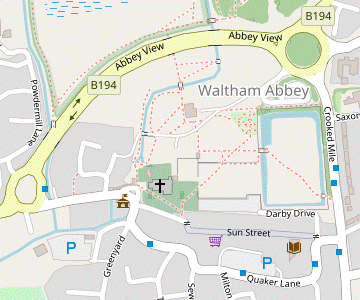
This section starts in front of the Church of the Holy Cross & St Lawrence?, which has a statue of King Harold? high up on its south wall.
- Even if you skip the entire circuit around the town (by retracing your outward route along Highbridge Street to the large roundabout), the church is well worth a visit.
- Take the path heading N from the parking area in front of the church, passing the Rectory on your right, to come to the Mill site. Cross the narrow footbridge over the left-hand of the two mill-races to continue briefly alongside the Cornmill Stream, then cross it on a wide bridge to pass through the Abbey Gateway?.
- Keep ahead on the main path through the Abbey Gardens? (or slightly to its left to inspect a tall wooden sculpture, the Ancestor?). The path swings left and right as it passes the Church Centre and approaches a walled garden.
- You could enter this Rose Garden through the colourful Sun & Moon gateway, but if you stay on the path to its left you will go over a mosaic marking the Greenwich Meridian?; there is another entrance to the garden on its northern side, opposite the site of the medieval Bloomery Forge?.
-
Take any route through the Rose Garden and leave via an exit on its southern side, opposite the Forge. Unless you want to cut out the loop through the town, fork left where the path splits outside the garden.
- For a short cut, fork right and head back towards the church, eventually going through a gap in the brick wall into the churchyard. In the grassy area behind the east end of the church there is an information panel; from there you can either resume the directions at [?] for the meadows loop, or carry on past the church and go back along Highbridge Street to the roundabout.
- The tarmac path from the Rose Garden comes to a path crossing where you turn left to cross a moat into the old Abbey Orchard (and wildflower garden). Take any route across it to the far right-hand corner. Cross the other arm of the moat on a wooden footbridge and go out onto a road (Crooked Mile).
- Turn right onto the road, then turn right again at the traffic lights into Quaker Lane. Where this road swings left go straight ahead into the pedestrianised Sun Street, passing The Angel pub on the right and the Epping Forest District Museum? in an attractive half-timbered building on the left.
- Further along you pass a closed pub (The Sun) and go over another pavement mosaic marking the Meridian?. At the end of Sun Street bear right across a corner of Market Square and re-enter the churchyard through a passage at the side of another closed pub (the Welsh Harp).
-
Unless you want to cut out the loop through the meadows, go straight ahead to an information panel in the grassy area behind the east end of the church.
- For a short cut, turn half-left onto the tree-lined path leading to the west door of the church and go back along Highbridge Street to the roundabout.
- The panel is by a stone slab memorial marking King Harold's possible burial site. From there head NE to a gap in the brick wall leading back into the Abbey Gardens; to the left of the gap the remnants of a medieval Slype? can be seen behind an iron grille. At the other end of this short passageway take the path heading N across the gardens to cross over your outward route.
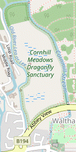
- Continue on the path to the left of the Church Centre, still heading N. Leave the gardens by crossing a footbridge over the Cornmill Stream and head towards the ring road (with the top of the medieval Stoney Bridge just visible off to the right). Follow the path through a subway under the road and go through a wooden kissing gate into Cornmill Meadows Dragonfly Sanctuary?.
- Unless you want to do the optional extension, turn left and go along the broad grassy path parallel to the ring road to the south-western corner of the water meadow.
-
Optional Cornmill Meadows Extension (+1¾ km)
-
For the extension turn right onto a grassy path across the meadow, gradually moving away from the wooden fence on your right. Turn left in front of the Cornmill Stream, passing the Abbey Fishponds.
- Follow the perimeter path all the way to the north-eastern corner, where there is an information panel about the Dragonfly Sanctuary. Ignore a footbridge across the river and turn left to stay inside the meadow.
- The path soon bends left again to head S, soon with some derelict buildings of the Royal Gunpowder Mills? site visible across the Old River Lea.
- Halfway along this stretch you could make a short detour to Wake Hide on the left. Shortly before reaching the south-western corner the perimeter path goes past an information panel about the Calico Ditches?.
-
In the south-western corner of the meadow go through a wooden kissing gate and up a grassy slope. Turn right onto the ring road, crossing the Old River Lea. Follow the pedestrian path and then Lea View around two sides of the large roundabout to return to Highbridge Street.
- Highbridge Roundabout to the White Water Centre (1 km)
- Retrace your outward route for 250m, back to the road bridge across the two river channels. Take the path alongside the Flood Relief Channel for 200m, then turn left into the Showground. Follow a path across it to the footbridge over the Lee Navigation in front of the White Water Centre.
-
As there are no alternative river crossings you now have to retrace your outward route for 250m, along the right-hand side of the main road to reach the bridge across the two river channels.
- If you want to abandon the walk, Waltham Cross station is 1 km away on the A121: see the Walk Map.
- For a different route back to the White Water Centre, turn right onto the broad path between the two channels. Follow the path for 200m as it swings round to the right alongside the Flood Relief Channel, passing the Viking Ship sculpture on the left. Before it curves back to the left, turn left through a metal fieldgate into the Showground.
-
Follow the broad path through this large open area, at first tracking a line of pylons and later veering left to head W. On the far side the path briefly merges with your outward route as you cross the navigation again on a high footbridge, with one of the entrances to the Lee Valley White Water Centre? down the slope to your left.
- The walk route continues on the path curving off to the right, but it is worth detouring into the centre to see the Olympic Course. If it is operating you can watch the canoeists from a footbridge over the course, and you can get some mid-afternoon refreshment in the Brew Street Kitchen and Bar.
- The White Water Centre to Cheshunt Station (2 km)
-
Take the path heading north-west away from the Lee Navigation. After crossing the Small River Lea fork right to head north along the eastern side of Bowyers Water. At the far end take either of two paths ahead, which rejoin after 500m. In a further 250m turn left onto a lane to reach the station.
- If finishing the Short Circular Walk, there are some pubs and a café a little way further along Windmill Lane.
- Take the surfaced path heading NW away from the bridge over the navigation. Follow the path past a sign for the Country Park's Disc Golf Course and across the Small River Lea on a footbridge.
- In 200m fork right and keep right at further path junctions to head N, soon with the large Bowyers Water on your left. In the north-eastern corner of the lake the path forks and you can take either route: both go past a large wooden sculpture.
-
Giant's Chair route
-
Fork left at the path junction. In 75m the route continues ahead at the next path junction.
- A short out-and-back detour to the left would bring you to a viewing platform over an Orchid Area in front of the lake.
- Continuing on the main route, the path merges with another from the left and goes along the right-hand side of a meadow (Thistly Marsh), soon passing The Giant's Chair sculpture on the right.
- In a further 150m fork right onto a path through some trees. Cross the Small River Lea on a footbridge and turn left onto a cycle path, rejoining the other route.
-
Green Man route
- Fork right at the path junction to cross the Small River Lea on a wooden footbridge. Where the path splits again in front of The Shrine sculpture (of a ‘Green Man’), fork left.
- In 150m the path merges with a cycle path coming from Waltham Common Lock. In a further 300m the other route rejoins from a footbridge on the left.
- Follow this cycle path for 250m, passing a group of wooden sculptures in a clearing on the right along the way. At the end turn left onto Windmill Lane to come to the small car park at the start of the Main Walk, in front of the level crossing at Cheshunt Station.
-
Finishing at Cheshunt Station
-
There is a direct entrance to Platform 1 on the left (for Greater Anglia trains to London), but if this is locked you will have to cross the tracks to the main entrance and use the station footbridge. London Overground trains leave from Platform 3.
- If the snack bar on Platform 2 is closed and you want some refreshment, there are several places a little way along Windmill Lane. In less than 150m you would pass The Windmill and The Red Cow pubs on the left, Rose Café and The Maltsters pub on the right.
- Cheshunt Station to Aqueduct Lock (2¼ km)
- Go through the car park and take any convenient route to the North Metropolitan Pit, eg. on the grassy strip between the two surfaced paths. After crossing the Small River Lea turn left and take lakeside and woodland paths close to the stream for 1½ km, eventually joining the Lee Navigation for a short stretch to Aqueduct Lock.
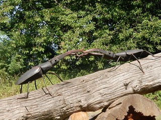
- For the continuation to Broxbourne go through the small car park. The most direct route is along the right-hand path beside the Small River Lea, but if you have already done this at the start of the Main Walk you could take the other path (or the grassy strip between them). All routes come to a track at the end of the open area after 600m, where there is a Stag Beetles sculpture.
- A simple route would be to take one of the paths straight ahead, but the suggested route is to turn right briefly onto this track. After crossing the stream immediately turn left onto a path alongside North Metropolitan Pit. On the other side of the stream the alternative routes pass a Play Boulders sculpture and all routes rejoin at a brick bridge over the stream after 500m.
- The surfaced path continues on the right-hand side of the Small River Lea. In 400m fork right, avoiding another bridge over the stream at Turnford Brook. In 50m keep ahead on an unsurfaced path, leaving the main path which veers right. Ignore a small bridge on your left and follow this woodland path between more fishing lakes, keeping the stream on your left.
- In 500m the path bends right and weaves its way through the trees, soon coming out in front of the Lee Navigation. Turn left and go along its towpath for 250m to Aqueduct Lock.
- Aqueduct Lock to Broxbourne Waterside (2½ km)
- Turn off the towpath and again take narrow paths between a series of small lakes before returning to the River Lea at King's Weir. Follow its towpath for 1 km to reach a gate leading into a water meadow, Silvermeade. Either take a grassy path all the way through this meadow or simply remain on the towpath to Broxbourne Waterside, where the River Lea splits from the Lee Navigation.
- At the far end of the lock you could simply remain on the towpath, but the suggested route is to turn left down steps onto a path signposted to Ashley Lake. Turn right at a path T-junction in front of a lake (which is actually Marsh Pit) and follow the path up a small flight of steps, heading NW with the lake off to your left.
- In 200m the path turns half-right, crosses a ditch and goes through a patch of scrubland to a small car park. Ignore a path opposite and turn left to go out along the car track, which immediately bends right to head N. You pass Railway Pit on the left, Boot Pit and then Lee Pit on the right.
- At the end of the track turn right onto a lane and follow it back towards the Lee Navigation. After making your way around a metal fieldgate ignore a sharp left turn onto a lane, but turn left onto the towpath in front of a bridge over the river, keeping the navigation on your right.
- For the next 1 km it is simplest to follow the towpath, although near the start you could veer left down the bank and go through a large grassy picnic area, dotted with trees. On the towpath you would pass King's Weir and continue alongside the wide River Lea, navigable on this stretch.
-
At the end of the picnic area you come to Wharf Road car park and the only continuation is along the towpath for a further 600m. At the start of a line of trees there is a wooden kissing gate on the left with an information panel for Silvermeade?. Unless you came out through this water meadow on the Long Circular Walk, the suggested route is to go through this gate.
- If you have already been through Silvermeade (or if it looks flooded) simply continue along the towpath for 650m and resume the directions in §N, where the River Lea splits from the Lee Navigation.
- For the Silvermeade route, go through the gate and turn half-right to follow a faint grassy path all the way across the main part of the meadow, parallel to a stream on your left and passing several small fenced-off areas. On the far side go straight ahead through a wooden kissing gate and cross a tree-lined stream on a wide bridge into a smaller meadow.
- As the direct route across this part of Silvermeade can be waterlogged it is advisable to turn right and go around two sides of the triangular area. At the far end leave through a wooden kissing gate, rejoining the towpath where the River Lea splits from the Lee Navigation.
- Broxbourne Waterside to the Station (¾ • 1½ km)
-
 Either take the left-hand path past a café and the remains of an old mill (with an optional extension on a boardwalk circuit through some wetlands), or the right-hand path if you want to visit the Crown Inn. The routes rejoin at a footbridge over the mill-stream where a path leads under the B194 into the station car park.
-
Old Mill Café route (¾ • 1½ km)
- Take the left-hand path, which goes alongside the River Lea under a low railway bridge and into the car park for the Old Mill Retreat Café. In the marshy area behind the car park there is a horseshoe-shaped “Wetlands and Woodlands” trail, which you can do in either direction.
-
Optional Wetlands & Woodlands extension (+¾ km)
- The wetlands section starts from the back of the car park; the woodlands section between the café and a Canoe & Cycle Hire shed. Whichever direction you take, ignore steps up to an exit at the far end and return on the other path.
- Go past the Canoe & Cycle Hire shed to a road junction and turn right. Cross the river and immediately veer left through the ruins of Broxbourne Mill?.
- Follow a tarmac path running between the river and a small picnic area. Just before this goes under the railway, turn left up steps onto a metal footbridge.
-
The Crown route (¾ km)
- Take the right-hand path, which goes across the river on a footbridge and alongside the Lee Navigation. Go up to the next bridge and turn right onto a narrow lane to cross the Navigation. The Crown is directly ahead.
-
After visiting the pub, retrace your steps over the road bridge and follow the lane round to the right. Go past the Lee Valley Boat Centre and across another waterway.
- A short out-and-back detour up the steps on the right would reveal the site of Broxbourne Lido?.
- For the station, go down steps on the left and diagonally across a car park. In the far corner follow a tarmac path under the railway and immediately turn right up steps onto a metal footbridge.
-
To complete the walk, cross the River Lea and follow the path up a slope and under Station Road. The station? is at the far end of its long car park, with the entrance on the left. All the platforms are accessed via an overhead walkway, with trains to London leaving from Platforms 1 or 2.
- River Lee Country Park is a large open space between Broxbourne and Waltham Abbey. It is part of the linear Lee Valley Regional Park, which follows the course of the River Lea for 42 km from Ware to the Thames. [By convention the spelling Lee is used for constructed features such as the Navigation and the Country Park, whereas the natural river and place names derived from it are spelt Lea.]
- The River Lea runs for 68 km from its source in the Chilterns near Luton to the Thames in east London. It splits into several waterways (Old River Lea, Small River Lea, etc) as well as the constructed channels.
- The misleadingly-named New River is an aqueduct, constructed in the early 17thC to increase the supply of clean water to London.
- St Augustine, Broxbourne dates from the 15thC and contains several interesting memorials, including a tomb with effigies of Sir Henry Cock and his wife surrounded by their kneeling children.
- Silvermeade is an area of wet grassland dissected by a network of ditches. The fences along their sides are to protect the banks and provide a habitat for water voles.
- The Lee Valley White Water Centre was constructed to hold the canoe slalom events of the 2012 Olympic Games.
- The Royal Gunpowder Mills were acquired by the Crown in 1787, taking over a private business which had been operating for over a century. Production continued until 1945 when the site became a research centre for rocket propellants, but this too closed in 1991. A heritage centre has been open to the public since 2001.
- The 2012 Olympic Shield commemorates the building of the Lee Valley White Water Centre. It depicts King Harold surrounded by King Henry Ⅷ and various civic and Olympic plaques.
- Waltham Abbey Town Hall was built in 1904 in a Continental Art Nouveau style.
- The Church of the Holy Cross & St Lawrence, Waltham Abbey was rebuilt in Norman style between 1090 and 1150, the fourth church on the site. When construction of the abbey started in 1177 it was greatly lengthened eastwards but the extended nave, transepts and chancel were all demolished in 1540. The west tower was added in 1556 after the old (east) tower collapsed.
- King Harold (Godwinson) is said to have been cured of paralysis while praying before the Holy Cross when Earl of Essex. After his death at the Battle of Hastings in 1066 legend has it that his body was brought to Waltham, but some historians have speculated that he is buried in Bosham church, in West Sussex.
- The Abbey Gateway was the main entrance to the monastic area, with separate arches for horse-drawn vehicles and pedestrians. The interior wall is one of the earliest brick walls in the country, partly built with large medieval red bricks known as ‘Waltham Great Bricks’.
- Waltham Abbey Gardens were laid out by the Denny family, who built Abbey House on the site of the former abbey at the end of the 16thC. The house was demolished in 1770.
- The Ancestor sculpture (1992) was carved by artist Helena Stykianides from a single oak tree cut from Epping Forest. It represents an Augustinian canon and has a series of enigmatic images on the back.
- The Greenwich Meridian was established as the universal baseline of 0° longitude at an international conference in 1884. It runs through Waltham Abbey and is marked by pavement mosaics in Sun Street and the Abbey Gardens, as well as the ‘Sun & Moon’ gateway (1995) in the Rose Garden.
- The Bloomery Forge smelted iron ore and provided metalwork for the abbey and its farm (a bloom is an iron or steel bar in an intermediate stage of manufacture).
- The Epping Forest District Museum of local history is contained in two historic houses which have been skilfully combined into a single building.
- The Slype is a stone passageway with a vaulted ceiling leading into the cloisters, a remnant of the 12thC abbey.
- Cornmill Meadows Dragonfly Sanctuary is an area of partly-flooded rough grassland surrounded by slow-flowing rivers which together support many species of dragonflies and damselflies. It has been designated a Site of Special Scientific Interest (SSSI).
- The Calico Ditches are parallel ditches where cotton cloth was washed and then laid out in the grassland to be bleached in the sunshine.
- Broxbourne Mill is mentioned in the Domesday Book and produced flour until the late 19thC. In the 20thC the mill wheel powered a small engineering works, but the three-storey building burned down in 1949. It has been partially restored by the Lee Valley Regional Park Authority.
- Broxbourne Lido was built by the Lee Valley Regional Park Authority in 1978, but demolished only 30 years later because it did not meet contemporary health & safety standards.
- Broxbourne Station was relocated from its original Station Road site in 1959, hence the distinctively modern building (which is Grade Ⅱ listed) on a railway line which opened in 1840.
There is a choice of routes for this section. The main route in [?] is a long loop around the lake, with the opportunity to visit an Information Centre and bird hide on the far side. If you want to cut out this loop, turn right and follow the short cut directions in [?].
Continue the directions at §G.
If you are doing the short cut and not visiting Waltham Abbey, go to §K.
…
Note that there are no paths cutting across the meadow so you have to go all the way around them on this extension.
There is a choice of routes to the station, with the café route in [?] including the opportunity to loop around some wetlands on a long boardwalk. If the café has closed or you need something stronger, either take the pub route in [?] or detour to the town's High Street via Mill Lane (see map).
Note that if the back of the car park is under water, part of the boardwalk in the wetlands section will be flooded too.
Walk Notes
» Last updated: October 17, 2023
Return to Top | Walk Map | Walk Options | Walk Directions.