Christs Hospital to Billingshurst via Knepp Castle walk
Long flat walk with an emphasis on fauna in a re-wilding area, and passing several historic buildings.


Wild Exmoor ponies, Knepp Wildlands
Oct-18 • Saturdaywalker on Flickr
swcwalks swcwalk283 walkicon 45143418234
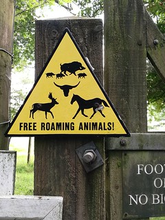
'Free roaming animals'.
You are about to enter the happy (e)state.
knepp rewilding freeroaming sustainability sustainablefarming 36334474333

photo from walk
Old English Longhorns - 'rescued from oblivion by the Rare Breeds Survival Trust in 1980.' Considered 'the perfect rewilding candidates' for Knepp.
longhorncattle knepp rewilding 36312086424
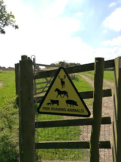
photo from walk
'Free-roaming animals' aka happy animals.
rewilding knepp freetoroam animalwelfare sustainablefarming 37148551125
![The Importance of Rootling Tamworth pig and piglets make their way to the pond for some more snuffling. Their presence is having positive effect: 'Rootling exposes bare soil, allowing pioneer plants like sallow (hybridised willow) to colonise. Sallow is the food source of the purple emperor butterfly. Before rewilding there were no purple emperors on Knepp. Now [it has] the largest breeding population in the UK. [The soil] is also colonised by solitary bees, and the over-turned clods of earth kick-start the creation of anthills which, in turn, provide food for Knepp's burgeoning population of green woodpeckers. Rootling also provides opportunities for so-called 'weed' species - like chickweed, scarlet pimpernel, vetchlings, common fumitory, knotgrass and red fescue - food source of the critically endangered turtle dove. Before...the rewilding [project there were] no turtle doves at Knepp. By 2017 [it had] at least 14 purring males, and...they are breeding because...fledglings [have been seen]. Turtle doves are, according to the RSPB, the most likely bird to go extinct within [the UK's] shores by 2020. Knepp is the only place in the country where turtle dove numbers are increasing. Could the turtle doves' success here be a consequence, at least in part, of [Kneep's] rootling pigs? - Knepp Rewilding.](https://live.staticflickr.com/4353/37006036761_8be5ca8d1b_n.jpg)
The Importance of Rootling
Tamworth pig and piglets make their way to the pond for some more snuffling. Their presence is having positive effect: 'Rootling exposes bare soil, allowing pioneer plants like sallow (hybridised willow) to colonise. Sallow is the food source of the purple emperor butterfly. Before rewilding there were no purple emperors on Knepp. Now [it has] the largest breeding population in the UK. [The soil] is also colonised by solitary bees, and the over-turned clods of earth kick-start the creation of anthills which, in turn, provide food for Knepp's burgeoning population of green woodpeckers. Rootling also provides opportunities for so-called 'weed' species - like chickweed, scarlet pimpernel, vetchlings, common fumitory, knotgrass and red fescue - food source of the critically endangered turtle dove. Before...the rewilding [project there were] no turtle doves at Knepp. By 2017 [it had] at least 14 purring males, and...they are breeding because...fledglings [have been seen]. Turtle doves are, according to the RSPB, the most likely bird to go extinct within [the UK's] shores by 2020. Knepp is the only place in the country where turtle dove numbers are increasing. Could the turtle doves' success here be a consequence, at least in part, of [Kneep's] rootling pigs? - Knepp Rewilding.
rootling tamworthpigs rewilding butterflies turtledove knepp bees sustainability endangeredspecies 37006036761
| Length |
27.1 km (16.9 miles), 6.5 hours. For the whole outing, including trains, sights and meals, allow 10 hours. |
|---|---|
| OS Map |
Landranger Map 198 with last 1 km on Map 197 (map not really needed), Explorer Maps OL34 and OL10. Christs Hospital W.Sussex GR TQ148292, Dial Post TQ155195 , Billingshurst TQ088251 |
| Toughness |
Difficult to assess as is very flat but long, and muddy in winter, probably 4 or 5 out of 10. |
| Features |
The aim of this walk is to visit the estate of Knepp Castle where a re-wilding project has been going for over 10 years. Good opportunity to see Old English Longhorn Cattle, Tamworth Pigs, Exmoor Ponies and Fallow and Roe Deer. The walk passes through this re-wilding area before and after the lunch stop. Before lunch views of Shipley windmill and Knepp Castle are seen, although neither are open to the public. After lunch pass by a listed farmhouse and an old Quaker Meeting House. Those shortening the walk by using the bus will pass what remains of Old Knepp Castle. |
| Walk Options |
The walk may be shortened by starting or finishing at Knepp Castle where the 23 bus from Horsham stops on the A24 at the Partridge Green turn. There is no useful bus stop at Dial Post and a more direct route to the bus stop from Dial Post is 2 km from the lunchtime pub.
|
| History |
Knepp Castle The castle was originally a motte and bailey castle built in the 12th century but rebuilt in stone by King John in 1214 and had a deer park still existant in 1549. Most of the old castle was pulled down in 1762 to make way for a turnpike road (now the A24) and what remains can be seen on the route to/from the Knepp Castle bus stop. The current castle was built in Gothic Revival style and only completed in 1812. Knepp Rewilding Project Started in 2001 in 3,500 acres of former arable and dairy farmland has been naturally transformed with free-roaming herds of Old English Longhorn cattle, Tamworth pigs, Exmoor ponies and Fallow and Roe deer. It has also become a stronghold for several other rare species: Purple Emperor butterflies (July-August), Turtle Doves (May-August) and Nightingales. About 6 km of the walk is within the re-wilding area. See www.knepp.co.uk Shipley Windmill The King's Mill or Vincent's Mill is a smock mill built in 1879 and worked commercially until 1926. It was owned by the writer Hilaire Belloc from 1906 until his death in 1953. Following restoration the mill was opened to the public in 1958 and later leased by the Shipley Windmill Charitable Trust but closed in 2009 when the owners would not renew the lease. St Mary the Virgin, Shipley This large church was built by the Knights Templar in the 12th Century. Barnhouse Farm A farmhouse, timber-framed with red-brick herringbone dating to 17th century and grade 2* listed on a farm known to exist in 1358. Blue Idol House Originally a farmhouse built around 1580, the Quaker meeting house remains virtually unchanged from 1600 although various extensions have been added and is grade two listed. A blue plaque commemorates William Penn who founded this Quaker Meeting House and the City of Philadelphia, giving his name to Pennsylvania. Many local Quakers sailed with him to America in 1691. It is only open to the public on Fridays from March to November 10-4. |
| Travel |
Take the train nearest to 8.30am (before or after, 9.00am on Sundays) from Victoria Station to Christs Hospital. Journey time 1 hour (hourly service). Trains back are from Billingshurst, one stop further on, but twice hourly. Buy a day return to Billingshurst. The early start is due to the lunchtime hours of the Crown Inn. If taking the 23 bus from Horsham station (stop L) alight at the Partridge Green turning stop. A train from Victoria to Horsham around 10am should be fine and connect with the hourly bus service. On Sundays buses are every 2 hours so check the times so can plan for your intended lunch stop. |
| Lunch |
Crown Inn, Dial Post 01403 710902 after 14.3 km (8.9 miles). A 16th century in on the village green with a menu ranging from sandwiches through to venison sourced from the re-wilding project. Note that food is only served to 2pm (2.30 Sundays) and closes at 3pm (Sunday 4). Not visiting the pub saves 0.5km, 0.3m There are two alternative pubs but are not conveniently located to be attractive to walkers other than those starting or finishing at Knepp Castle George & Dragon, Dragons Green 01403 741320 leaves route after 6.9 km (4.3 miles) and is a further 1.5km (0.9 miles) to the pub but adds only 0.6km (0.4 miles) to the length of the walk. Another 16th century inn in a tiny hamlet seving food until 2.30pm daily Countryman, Whitehall near Shipley 01403 741383 leaves route after 18.5 km (11.5 miles) and is 0.3km (0.2 miles) off route. Opens similar hours to the Crown and similarly uses local ingredients |
| Tea |
Railway Inn pub opposite the station. Alternative venues in the High Street are 650m beyond the station and are likely to be closed at the likely time of arrival. |
| Version | Fully updated 2018-02 |
| Profile | |
|---|---|
| Help Us! |
After the walk, please leave a comment, it really helps. Thanks! You can also upload photos to the SWC Group on Flickr (upload your photos) and videos to Youtube. This walk's tags are: |
| By Train |
Out (not a train station) Back (not a train station) |
| By Car |
Start RH13 0ND Map Directions Return to the start: Finish RH14 9SE Map Directions Travel to the start: |
| Amazon | |
| Help |
National Rail: 03457 48 49 50 • Traveline (bus times): 0871 200 22 33 (12p/min) • TFL (London) : 0343 222 1234 |
| Version |
Feb-18 Andy Poole |
| Copyright | © Saturday Walkers Club. All Rights Reserved. No commercial use. No copying. No derivatives. Free with attribution for one time non-commercial use only. www.walkingclub.org.uk/site/license.shtml |


Walk Directions
- Exit Christ's Hospital station through the station building or to the left of it, walk through the car park and turn right along the approach road, ignoring a path signed to the left in 40m. In 150m continue in the same direction, ignoring a left fork and in 120m keep ahead/slightly right when joining a more major road, now with a low hedge on the left.
- In a further 130m where the road bends right, and immediately after a bus stop on the left, fork left with the hedge signed ‘West Gate Private Road’. In 100m the road is joined by another coming in from the right and is blocked by (usually) closed gates into a private housing estate. Turn right here to find an earthen path signed ‘Downs Link’ which bears left following, on the left, the wire fence of the private estate.
- In 120m the path becomes paved and continues between hedges beside the railway line. In 350m this is then blocked by a gate. Ignore the bridleway turning left and instead bear right with the Downs Link to join the former railway track (which the Downs Link follows through the Adur valley, and joined the South coast line at Shoreham-by-Sea).
- Continue on the former railway line for 1.5km ignoring all side turns and passing under a minor road bridge (after 1km), a sign to Bax Castle PH and then a bench on the left. Eventually the path veers slightly right, leaving the course of the railway, and noticeably narrows.
- 130m later at the top of a slight rise and where another path joins from the left, [!] turn right over a stile to the right of a metal field-gate, and follow the left-hand edge of a field (direction 230°). In 200m in the field corner pass through a kissing gate and continue in same direction between gardens to a minor road 60m away.
- At the road turn left for 60m then turn right onto a footpath by squeezing past double metal gates into a field where you head for a corner of some trees 150m away on a faint path (direction 210°). You have splendid first views of the South Downs half left ahead. On reaching the trees cross a stile and continue ahead on a metalled driveway (a public bridleway).
- In 160m ignore a crossing path and bend left and right with the driveway which passes Chase Lodge. The now concreted driveway passes some more farm houses and in 300m from Chase Lodge at a 3-way signpost you ignore a left-turning footpath. In 70m pass Birchwood Cottages and curve right with its garden fence and to the right of a shed. In 20m turn left with a bridleway signpost along a tarmac drive towards Birchwood Lodge.
- In 50m on reaching the Lodge’s gate take the mud-prone path to its right leading into a wood 60m away and continue for another 50m to a major crossing track. Turn half left on this major track (170°), ignoring another major track turning hard left. In 20m ignore a path going sharply right, then in another 10m, before a wooden field-gate, turn right (initial direction 220°) and continue along the wide track until reaching a field 330m distant.
- Enter the field by a gate to the right of a wooden horse jumping fence and turn left to follow the field edge beside the wood. In 80m in the corner, where there is another horse jump, turn right to continue round the edge of the field. In 250m leave the field with a signpost along a track bearing left to a metal gate 20m away and continue ahead on the other side of it for 50m where join a more major track, continuing in the same direction.
- In another 40m this track crosses a stream and bends right to the farm-buildings of Trawler’s Farm 100m away, with a 3-way finger-post in front of a black brick and wood garage. Turn left here with the bridleway, passing the farm on the right, and continue for 200m to where the track bends left at a 4-way finger-post. (!) Continue ahead, with the footpath, turning off the bridleway track and also ignoring the bridleway that goes right, soon passing to the right of a covered hay shed and with a wood to your right.
- In 110m you enter the wood and 100m later drop down to cross a stream by a plank bridge then up the other side to a redundant stile, and ignoring a path that remains in the wood. In the large arable field beyond bear right on the wide grass verge keeping the wood to your right. In the corner cross to the next field over a plank bridge across a stream and turn left with a footpath signpost along a left hand field boundary, with a hedge on your left.
- In 280m pass through a metal field-gate in the field corner and turn right on a wide track between hedges (a bridleway). After 220m cross a stream and 130m later pass a white cottage on the left behind a pond. 70m after the cottage pass through the gate to a 4-way finger-post.
- If you are having an early lunch at Dragon’s Green turn right on the bridleway, which in 300m comes to a road corner where continue ahead. In 60m fork left at a road junction and in 250m at another road junction turn left to reach the George & Dragon just beyond the corner. Return the same way, but do not turn left onto the bridleway but continue on the road around to the right 500m to the main road. Cross the road into the lane ahead where both a footpath and bridleway are signed. Skip the next paragraph.
- For the main route continue ahead on a track 500m to the main road, the A272. Cross the road a little to the left to find a stile to the right of a metal field-gate. In the field veer to the left (to the right of a pond in the middle of the field, direction 155°) to another stile 60m away. Over the stile, ignore a left turning footpath and in 20m turn right on a bridleway by a signpost on the right. In 70m this becomes a concrete lane passing houses and leads back to the main road. Just before the main road both a footpath and bridleway are signed to the left.
- Both routes: Take the footpath, crossing a stile to the left of a metal field-gate and continuing uphill with a hedge on the left. In 250m pass through a gate to maintain direction on a path that is now enclosed with a hedge on the left and a wire fence and the field you were previously in to the right.
- Continue along this path for 550m until there is (!) suddenly a concreted patch with the track ahead looking more like a driveway with grass between definite tyre tracks and beside a 3-way finger-post. Ignore the path to the right and 10m later turn left through a metal gate, with the path dropping to a wooden kissing-gate 8m later.
- In the following field bear right diagonally with King’s Windmill in Shipley now visible ahead. In 150m continue in the same direction through a gate, ignoring another one to the left, to reach a road in 100m through a wooden kissing-gate, where our route goes left. But if you wish to have a closer look at the windmill, turn right on the road to turn left along a bridleway 30m later, returning the same way.
- Continue along the road (School Lane), past some parking spaces on your right to the junction with Red Lane where you turn right. In 80m at the end of the lane bear left through a metal gate to St Mary the Virgin church, with a view of the windmill to the right.
- Continue to the right of the church and when level with the second door into it, turn right to a gap with a metal kissing-gate, which you pass through and follow the hedge on the left with the River Adur meandering to your right. The permissive path continues to bend left with the hedge, with a loop of the river away to your right.
- 60m after passing a prominent tree on the left pass through a gap to the right of a wooden horse jumping fence then veer left uphill away from the river towards a metal field-gate to the left of a large tree on the horizon (direction 30°).
- Through the gate, entering a wood the path bends left and right to meet a cross path in 150m, where turn right to the edge of the wood. Ignore a path going left and enter the field ahead through a gate and continue with a hedge on your left. In 125m in the far corner with a house to the right pass through a gate as part of a metal field gate and, as the driveway splits, fork left to a road to cross it and to follow a footpath opposite through some trees. 25m along this path go through a high deer gate into the grounds of Knepp Castle.
- Continue ahead on the grassy path in the direction of a signpost on the left to reach a paved driveway in 300m and turn right with another signpost along the drive. In 250m you are directed off to the right again by a signpost across the grass and Knepp Castle comes into view in 100m on your left as you walk diagonally away from it.
- In 250m you reach another castle driveway where you turn right along it and soon bend left with it. 400m after joining this driveway, and 80m after the wood restarts on the left, turn right immediately before Trollards Barn.
- If heading for the bus stop from here, do not turn right but continue ahead for 1km, passing the Kneppmill Pond on your left and the ruin of Old Knepp Castle on your right before reaching the A24 where you turn left for the bus stop 80m away.
- Main route: Cross the field with a line of trees and a wire fence to your left down to the River Adur which you cross by a series of bridges to a gate beyond with a 3-way finger-post. Ignoring the fingers go through the gate and go half-right up the field (direction due W, the right of way heads right for 50m before turning left), passing a middle of the field tree to its left and heading to another high deer gate in the hedge ahead and onto a road.
- Turn right along the road for 160m until just before a triangular road junction, where you turn left along a car wide track (a signposted footpath, initially gravel, then tarmac, then concrete). In 300m having passed Hammer Farm either cross a cattle-grid or go through a high deer gate as the track becomes gravelled to continue along it passing a hammer pond on the right before it climbs and bends right and left.
- 250m after the pond the track forks, go left, flat at first but then dropping to cross a stream in 210m (Lancing Brook, on the OS map) and up the other side to New Barn Farm and another high deer gate 60m away
- 10m after passing through the gate turn right (direction 230°), past a pond on the left and then through another high deer gate where the Knepp Rewilding Project starts. Cross the field with a fence on the left and in the field corner pass through a metal field-gate (!) but do not cross the stream ahead, instead turn left keeping the stream to your right.
- In 360m ignore a prominent cross path by a signpost with number 4 with another bridge over the stream on the right and continue ahead for a further 180m, at the end of which pass through a small patch of scrub and trees to a post with number 5 on it.
- Turn left on an unmarked permissive path with a hedge on your left for 130m where you pass through a gap into the next field. 70m into this field by an unnumbered post turn right gently uphill to the end of the field in 180m.
- If not going to the pub in Dial Post cross into the next field, ignore the high wooden kissing-gate 20m to your left, and turn right. Skip the next paragraph.
- To reach the pub cross into the next field and turn left to go through a high wooden kissing-gate, then a metal one and a third kissing-gate 90m later to reach Dial Post green in 40m. Cross the green to find the Crown Inn opposite. After lunch return the same way through the 3 kissing-gates and continue in the same direction along a right-hand field boundary. If heading for the bus stop from the pub see the directions at the end.
- To continue the walk continue ahead on a gravel path with field hedge to your right and newly planted trees on your left. In 220m in the field corner bear right through a gap and continue ahead in the next field. In 170m at a corner of a wood on the right continue in the same direction across another field, heading for the wood ahead (direction due W).
- Reaching the wood in 350m, continue ahead through a gap for 15m to a finger-post where you turn left, passing a house on the right. In 50m reach a track and turn right, staying on it as it bends left then right in 60m.
- Follow the track with a hedge to the right and open fields to the left for 400m to a cattle grid and high gate. Go over or around as you prefer leaving the Rewilding Project. In a further 150m reach Bentons Place Farm and turn right along a signposted bridleway just before a farmhouse with a willow tree in front.
- In 90m turn left with the track and in 10m [!] continue in the same direction along a narrow path into a wood, where the track turns left. In another 30m ignore a footpath turning right through a high deer gate but in 140m turn right with a footpath and permissive bridleway signpost over a two-railed plank bridge across a ditch, re-entering the Rewilding Project land through a high gate. On leaving the wood in 60m bear left at a T-junction with a car wide track, keeping the wood to the left and 120m later turn right along a broad bridle path at a 4-way junction (direction 15°).
- Continue along the path for almost 1km, on the way passing a pond with a hut on your left, bending right and then left, and a lookout on the right (worth climbing as gives a view of a pond where deer often drink) and an open barn on your left (Lower Barn on the OS map). At a path junction where the main path bends right (150m past the lookout and 30m past the barn) turn left.
- This path soon bends right and in 80m crosses a stream on a low brick bridge where you turn left with the right of way, ignoring a permissive path (trodden but not signed) straight ahead. Continue for 550m through three fields with a hedge on the right.
- 20m into the fourth field turn right over a plank bridge by finger-post No.32, ignore an immediate crossing path continue up the left-hand edge of the field until directed right at the field corner (post No.33). At the next post in 80m (No.34) you turn left over a stream and continue up the right-hand side of the field towards Smoke House Farm. Veer to the left of a corrugated iron shed to another high gate to finally leave the Rewilding Project.
- Cross over a ditch to the road where turn left (turning right leads to the Countryman pub in 300m). In 80m turn right with a footpath signpost through a wooden field-gate, passing a wooden barn on the left and continuing with a hedge on the left, and ignoring all gates on the left. At the far side of the field pass through a double gate into the next field and bear left with the hedge. In 170m continue through a metal kissing gate into a third field. The right of way leads to a stile 200m away in the opposite corner (to the right of the prominent tree in the middle of the field), but seems permanently blocked by electric fencing w/o handle bars. Thus head towards a metal gate 50m to the left of the stile (direction 310°) to a green lane, where you turn left.
- After 80m (or 130m from the stile) ignore a bridleway going sharp right and (!) 30m later turn right through a gap to the right of a gate to reach a drive in 25m, where you turn right again and follow the drive around a left-hand bend in 20m. In 140m, by a wooden garage on the left, [!] turn left with a footpath marker post on the right along a short drive towards what looks like another garage (also signed ‘The Pigsty’ on a right-hand wall). Walk through the ‘garage’ and in 30m bear half-right between fences.
- The fences quickly become hedges and you are directed right into a garden. The right of way on the map seems to continue ahead roughly parallel to the buildings on the right, but simplest to follow the suggested route to continue ahead following a hedge curving around the gardens to a waymark post, somewhat to the left of the path on the map. From the marker post continue in the same direction (290°) across a field (and not bending round to the left) to a fairly hidden stile half-way along the far fence, which leads you beside a pond on your right with a fake heron.
- Past the pond, cross a stile into a field and turn right along the edge to another stile in the field corner in 75m that leads to a driveway. Grade II listed Barnhouse Farm can be seen to the right (foliage permitting), but you turn left along the long drive to a lane 400m away, where you turn right. Continue along this lane to cross the B2139 in 430m and continue in the same direction to Sproutes Farm.
- At Sproutes Farm, after having passed the farm house on the right, cross a bridleway and continue ahead between farm buildings and caravans. Once through the buildings, in 220m, where the track bends left go half-right through a metal field-gate onto an enclosed bridleway. Continue for 430m until a gate leads you into a small tree belt. 50m later turn right onto a woodland path at a 3-way bridleway signpost.
- In 200m go through a gate and over a stream and in another 200m the path becomes a paved lane with houses on the left and various paths off which you ignore. Continue up the lane passing Blue Idol Quaker Meeting House, also Grade II listed, in 600m on your right.
- 220m beyond the meeting house turn left on paved drive by a footpath signpost to find a fenced in path in 40m to the right of a residential gate. The path bends right in 100m by a small (Quaker) graveyard, and then left to a field. Cross the field, slightly to the left (direction 270°), through another gate, and then slightly right past a pond and buildings, both on the right, to a road.
- Turn right on the road for 230m, and 40m after passing ‘Chantry’ on the left with its signs for free range eggs and pork, turn left through a metal gate on a path. In 100m the path enters a large field where turn left along the field edge as signed and then right along the top of the field on an unpaved drive for 270m, passing old farm buildings along the way, one of which has recently been converted.
- In the far corner cross a stile, maintaining your direction, now beside a hedge on the left. In 200m cross a stile to the left of a metal field-gate and continue ahead on a paved track for 420m. With a busy road 100m ahead, (!) turn sharp right at a 3-way footpath signpost through a wooden gate with a ‘No Horses’ sign.
- At the corner of a wood in 60m go half-left to walk beside the wood. In 140m in the field corner continue through a gap into another field. In 150m in the next field corner go as directed left into the wood and in 15m turn right by a marker post to resume your original direction.
- Follow this woodland path for 300m (with a pond on the left after 150m) to a path T-junction with a 3-way signpost. Turn left for 280m to another pond, this time on the right. 20m later ignore a cross path and 10m after that fork right as signed, downhill (initial direction 310°).
- In 170m at the bottom, with a field visible through the wood ahead, turn left on a cross path. The field on the right ends and becomes housing, and in 120m at a cross path with a 4-way signpost, continue straight ahead. The path then becomes enclosed and in 450m comes to a road where you turn right for 300m to Billingshurst station.
- Trains for London go from the far platform, reachable by either the bridge over the level crossing or through the ticket office, when open. The Railway pub is opposite the station is a possible tea place, otherwise continue towards the High Street 650m beyond the station.
Dial Post to the bus stop at Partridge Green turn
Finish the walk at the Partridge Green turn bus stop.
- Leaving the pub turn right on the road for 60m and fork left into Swallows Lane, sign-posted to Shipley. Follow road for 1km, passing on the right Swallows Farm buildings then a footpath before some railings of a bridge over a stream (180m before the turn off). Shortly before the next house on the right turn right on a bridleway (if you reach houses on the left you have gone about 200m too far).
- Entering the field follow the hedge on the left to the corner then follow a line of telegraph poles across the field to a line of trees 250m away. Cross the line of trees continuing ahead now with trees on your left downhill to cross the River Adur.
- Having crossed the bridge (!) go half right up the hillside for 200m to the driveway of Knepp Castle where turn right for 650m, passing the ruin of Old Knepp Castle soon visible on your right. Continue to reach the A24 where you turn left for 80m for the bus stop
Bus stop at Partridge Green turn to Knepp Castle
Start the walk at the Partridge Green turn bus stop.
- Get off the bus at the Partridge Green turning bus stop and cross the main road with care. Take the road to the right of a white house signed for Floodgates Farm. In 100m pass through a metal gate beside a road gate and 200m later cross a cattle grid. At a gap in the hedge on the left between these gate and the cattlegrid can be seen the remains of Old Knepp Castle, largely destroyed to make a road that has become the A24.
- Continue in on the paved driveway for 1km from the road until shortly after passing Kneppmill Pond you come to a house called Trollards Barn. Turn left immediately after it to join the main route at no. 25. However it is worth continuing up the drive for another 400m when the drive bends right and the new Knepp Castle comes into view. The view improves if you continue left as directed off the drive to the other side of the large tree. Return to Trollards Barn and turn right.