Crickhowell Circular via Mynydd Llangatwg and Craig y Cilau Walk
Llangattock Escarpment with surreal slag heaps, quarries and cliffs, optional caving and a raised bog. Then lush pastures along the Usk Valley with Black Mountains views.

The Lonely Shepherd and Sugar Loaf and The Skirrid
SWC Walk 370 Crickhowell Circular via Mynydd Llangatwg and Craig y Cilau
Aug-20 • thomasgrabow on Flickr
banner swcwalks swcwalk370 50366639848

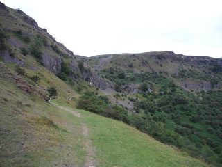
Llangattock Escarpment, from Cwm Onnau
SWC Walk 370 Crickhowell Circular via Mynydd Llangatwg and Craig y Cilau
Sep-20 • thomasgrabow on Flickr
banner swcwalks swcwalk370 50367327326
![The Lonely Shepherd with Gilwern Hill and Blorenge/Blorens SWC Walk 370 Crickhowell Circular via Mynydd Llangatwg and Craig y Cilau [taken by Jenny P]](https://live.staticflickr.com/65535/51535634203_92ab802216_m.jpg)
The Lonely Shepherd with Gilwern Hill and Blorenge/Blorens
SWC Walk 370 Crickhowell Circular via Mynydd Llangatwg and Craig y Cilau [taken by Jenny P]
Sep-21 • thomasgrabow on Flickr
swcwalks swcwalk370 banner 51535634203

Quarries, spoil heaps and scarps: Darren Cilau
SWC Walk 370 Crickhowell Circular via Mynydd Llangatwg and Craig y Cilau
Aug-20 • thomasgrabow on Flickr
walkicon swcwalks swcwalk370 50366638478
The Chwar Mawr
SWC Walk 370 Crickhowell Circular via Mynydd Llangatwg and Craig y Cilau
Aug-20 • thomasgrabow on Flickr
swcwalks swcwalk370 walkicon 50366637093
| Length |
18.9 km (11.7 mi), with 680m ascent/descent. For a shorter or longer walk see below Walk Options. |
|---|---|
| Toughness |
6 out of 10, with 6 hours walking time. |
| Walk Notes |
From the centre of the rightly popular town of Crickhowell, the route leads across the Usk River and the Monmouth & Brecon Canal up steeply through quiet pastures-with-views up to the easterly end of the Llangattock Escarpment and the fascinating limestone pinnacle of the Lonely Shepherd, overlooking the Clydach Gorge. From there you follow the escarpment westwards, past ex-quarries, surreal looking grassy spoil heaps, a couple of raised bogs and some extensive cave systems leading deep into the underlying limestone layers.
|
| Walk Options |
A bus stop of line 43 at Hillside Road, Llangattock enables a start there (cut 1.0 km).
|
| Maps |
OS Explorer: OL13 (Brecon Beacons National Park – Eastern Area)
|
| Travel |
Crickhowell Square Bus Stop, map reference SO 218 183, is 221 km west northwest of Charing Cross, 89m above sea level and in Powys, Wales. It is served by lines 43/X43 (Abergavenny – Brecon) with 12 buses a day Mon-Sat and 5 on Sundays and Bank Holidays. Saturday Walkers’ Club: This walk is doable as a daywalk from London, especially if you have motorised transport, but also if taking a train to Abergavenny to connect to above bus service. |
| Lunch |
Picnic. Best location: on the grassy ledge below the Llangattock Escarpment, with views across the Usk Valley. |
| Tea |
The Old Rectory Hotel Ffawyddog Road, Llangattock, Powys, NP8 1PH (01873 810 373). The Rectory is located 1.2 km from the end of the walk.
Several Cafés in Crickhowell, see the walk directions for details. |
| Brecon Beacons/Bannau Brycheiniog |
The Brecon Beacons/Bannau Brycheiniog National Park is in south Wales. It consists of bare, grassy, glacial mountains, with north facing escarpments. Its peaks, just shy of 1,000m (3,000ft), are the highest mountains in the southern UK. The national park is also noted for reservoirs, and the Dan yr Ogof caves. Its 4 mountain areas, from west to east are:
|
|---|---|
| Mountain Safety |
This is a challenging but achievable walk in good weather, even for young children, but it is in remote exposed mountain areas. It is possible to twist an ankle on any walk, and it will take hours for mountain rescue to drive to the trailhead, then climb the mountain, to reach you. So:
|
| Welsh Glossary |
aber: estuary, confluence, river mouth; afon: river; affwys: abyss; allt: hillside, cliff; aran: high place; ban/fan/bannau (pl): peak/beacon/crest, hill/mountain; big: peak; blaen: source of river, head of valley; bod: dwelling; bre: hill; bron: hill-breast; bryn: hill; bwlch: gap/col/pass; cadair: chair; cae: field; caer/gaer: stronghold, fort; capel: chapel; carn/garn/carnedd/garnedd: cairn, heap of stones, tumulus; carreg/garreg: stone, rock; castell: castle; cefn: ridge, hillside; celli: grove/copse; cerwyn: pot-hole; cist: chest; clog/clogwyn: cliff; clun: meadow; clwyd: hurdle/gate; clydach: torrent; coch/goch: red; coed: wood; craig/graig: rock; crib/cribyn: crest, ridge, summit; crug: mound; cul: narrow; cwm: hanging valley/corrie/bowl/dale; cyfrwy: ridge between two summits (saddle); ddinas: fort; dibyn: steep slope, precipice; dim: no; din: hill-fortress; disgwylfa: place of observation, look-out point; dôl: meadow; du/ddu: black, dark; dwfr/dŵr: water; dyffryn: valley; -dyn: fortified enclosure; eglwys: church; eira: snow; eisteddfod: meeting-place, assembly; esgair: ridge; fach/bach: small; fawr/mawr: large; fechan: smaller; ffald: sheep-fold, pound, pen, run; ffordd: way, road; ffridd: pasture; ffrwd: stream, torrent; ffynnon: spring/well; gallt: wooded hill; ganol: middle; garth: promontory, hill, enclosure; glan/lan: river-bank, hillock; glas: green (when referring to grass, pasture or leaves), blue (when relating to the sea or air); glyn: deep valley, glen; gors: bog; gorsedd: tumulus, barrow, hillock; gwyddfa: mound, tumulus; gwylfa: look-out point; gwyn/gwen: white; gwynt: wind; hafn: gorge, ravine; hafod: summer dwelling; hen: old; hendre(f): winter dwelling, old home, permanent abode; heol: road; hesgyn: bog; hir: long; is: below, lower; isaf: lower/lowest; llan: church, monastery; llawr: level area, floor of valley; llech: slab, stone, rock; llther: slope; lluest: shieling, cottage, hut; llwch: lake, dust; llwybr: path; llwyd: grey, brown; llwyn: bush, grove; llyn: lake; llynwyn: pool/puddle, moat; maen: stone; maes: open field, plain; mawn: peat; mawnog: peat-bog; melyn: yellow; merthyr: burial place, church; moel/foel: bare, bald/bare hill; mynydd: mountain, moorland; nant: brook/stream, dingle/glen; neuadd: hall; newydd: new; ogof/gogof: cave; pant: hollow; parc: park, field, enclosure; pen: head, top/end, edge; penrhyn: promontory; pentre(f): homestead, village; perfedd: middle; perth: bush, brake, hedge; plas: hall, mansion; pont/bont: bridge; porth: gate/gateway, harbour/bay/landing-place/ferry; pwll: pit, pool; rhiw: hill, slope; rhos: moor, promontory; rhudd: red, crimson; rhyd: ford; sarn: causeway; sgwd/rhaeadr: waterfall; sticill: stile; sych: dry; tafarn: tavern; tâl: end, top; talar: headland (of field); tan/dan: below; tarren/darren: escarpment; tir: land, territory; tor: break, gap; tre/tref: settlement, hamlet, town; twlch: tump, knoll; twll: hole, pit; tŵr: tower; twyn: hill; tŷ: house; uchaf: upper, highest; uwch: above, over; waun/gwaun: moorland, meadow; wen/wyn: white; y, yr, ‘r: the; ynys: island, holm, river-meadow; ysgol: ladder, formation on mountain-side/school; ysgwydd: shoulder (of mountain); ystafell: chamber, hiding-place; ystrad: wide valley, holm, river-meadow. |
| Profile | |
| Help Us! |
After the walk, please leave a comment, it really helps. Thanks! You can also upload photos to the SWC Group on Flickr (upload your photos) and videos to Youtube. This walk's tags are: |
| By Car |
Start Map Directions |
| Amazon | |
| Help |
National Rail: 03457 48 49 50 • Traveline (bus times): 0871 200 22 33 (12p/min) • TFL (London) : 0343 222 1234 |
| Version |
May-23 Thomas G |
| Copyright | © Saturday Walkers Club. All Rights Reserved. No commercial use. No copying. No derivatives. Free with attribution for one time non-commercial use only. www.walkingclub.org.uk/site/license.shtml |


Walk Directions
Full directions for this walk are in a PDF file (link above) which you can print, or download on to a Kindle, tablet, or smartphone.
This is just the introduction. This walk's detailed directions are in a PDF available from wwww.walkingclub.org.uk