Crowhurst to Battle walk
Gentle woods and fields, the Battle of Hastings, and Battle Abbey

Battle, East Sussex
battle book1 eastsussex 1066 walkicon swcwalks walk35 9513081072
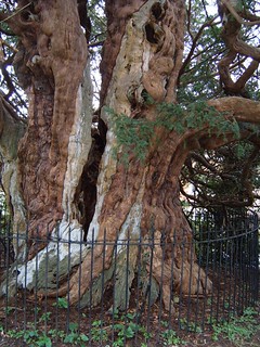
ancient_tree
Mar-05 • Andrew Murphy on Flickr
walk battle book1 crowhurst swcwalks kentweald walk35 2330266569
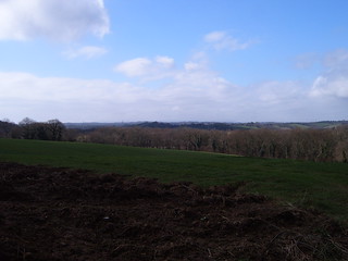
weald_view
Mar-05 • Andrew Murphy on Flickr
walk battle book1 crowhurst swcwalks kentweald walk35 2330266989

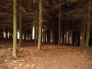
dark_forest
Mar-05 • Andrew Murphy on Flickr
walk battle book1 crowhurst swcwalks kentweald walk35 2330267411

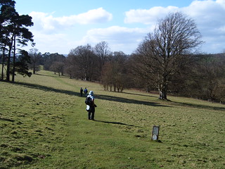
path_through_field
Mar-05 • Andrew Murphy on Flickr
walk battle book1 crowhurst swcwalks kentweald walk35 2330267917
Battle of Hastings & its abbey
| Length |
20.0km (12.4 miles), 5 hours 45 minutes. For the whole outing, including trains, sights and meals, allow 11 hours. |
|---|---|
| Toughness |
4 out of 10. |
| OS Maps |
Explorer 124 or Landranger 199. Crowhurst, map reference TQ 760 128, is in East Sussex, 6km north-west of Hastings. |
| Features |
Down the road from the station is the church and ruined manor of Crowhurst, and from farmland nearby – on a clear day – you can see Beachy Head and the sea. The potentially muddy route in winter goes through the woodlands and golf course of Beauport Park, to the church and lunchtime pub in the village of Westfield. It is 9.3km (5.8 miles) to this lunch stop. In the afternoon the route is mainly alongside streams or the River Brede, and passes through the parkland of the former Pestalozzi Children's Village. Soon the town, church and abbey of Battle are visible ahead, lining the horizon. You may like to end the day wandering over the site of the Battle of Hastings, by the ruins of the abbey that William the Conqueror built in honour of his victory, and so to the tree marking the spot where King Harold is supposed to have been slain. In high summer, many of the morning and afternoon paths can be overgrown, so long sleeved shirts and long trousers are highly recommended - no shorts, and do bring along a walking pole to beat back the overgrowth and omni-present prickly brambles. |
| Walk Options |
Shortening the walk. You could get a bus or taxi from near the lunchtime pub in Westfield (turn left out of the pub on Main Road and walk 50 metres), or from near the pub in Sedlescombe (5km further on). For bus information phone 0871 200 2233. A short cut to the station, as you enter Battle, is detailed in the walk directions below. |
| History |
The churchyard in Crowhurst has a perhaps 2,500 year-old yew tree. Next to the church is a ruined manor house, built in the twelfth century by Walter de Scotney, supposedly a gentleman of substance, who made do with this dwelling that was a mere 6 metres by 12 metres. In 1100, St John the Baptist Church in Westfield, along with a pit for the ordeal of trial by water, was given into the care of Battle Abbey. Some of its church bells are thought to have been cast in a pit dug in the churchyard, so as not to have to transport the finished bells. The church lost its stained-glass windows in World War II. The Battle of Hastings was fought on October 14th 1066, starting at 9am with Harold's unmounted forces on top of Senlac Hill (Battle), under attack from William's mounted knights, protected by infantry and archers. The Normans feigned a retreat to get the English to break ranks, and at dusk King Harold was killed. The Abbey Site (tel 01424 773 792) is open in winter on Saturdays and Sundays only from 10am until 4pm and in summer (01 April to 30 September) on Wednesday to Sunday until 6pm. The site is owned by English Heritage and admission (2022) is £12-90 or £ 14-20 with a (requested) donation. Concessions, and off-peak lower charges, are available. The Pestalozzi International Village was a 170 acre estate in Sedlescombe. It operated from 1959 to 2018 as an education charity, based on the principles of Swiss educationist and philosopher Johann Pestalozzi, who believed young people would fulfil their potential if they were given a balanced, holistic education, to develop their intellectual and practical skills (head, heart and hands). Young students, chosen from developing countries and with disadvantaged backgrounds, but already showing a commitment to helping their own communities, came to study at the Village for the International Baccalaureate. After their studies, and any subsequent university courses, the students returned home, where they contributed to the development of their own countries. In 2018 the school closed and sold up to a travel company which (since May 2021) has been seeking planning permission from Rother District Council to use the property as an oudoor adventure centre and an adventure holiday centre for school parties. But the ethos of Johann Pestalozzi is not lost and the international students now attend other residential centres in England and Wales. |
| Travel |
Take the train nearest to 9.15am from Charing Cross Station to Crowhurst . Journey time 1 hour 30 minutes. Trains back from Battle run about twice an hour until 6pm, and then hourly. Journey time about 1 hour 20 minutes. Buy a day return to Crowhurst. |
| Lunch |
The suggested lunchtime stop is the The New Inn (formerly known as The Old Courthouse) (tel 01424 752 800, some 9.2 km into the walk, which serves good quality, reasonably priced food. Lunch is served Tuesday to Saturday 12 noon to 2-30 pm, and on Sundays 12 Noon to 6 pm - closed on Mondays apart from Bank Holidays. The pub has pleasant indoor and covered external eating areas. Booking ahead advised on Saturdays and essential on Sundays. What used to be your alternative (involving a slight detour) to the Plough Inn, The Moor, Westfield, has been CLOSED since 2017. The pub was sold at auction in March 2018 and re-sold at auction in March 2021. Planning permission has been granted to the new owners (July 2021) for 3 dwellings plus a micro pub. When built and operating, information on the micro pub's opening hours will be added to this website. For those requiring provisions for a picnic, there is a Londis Village Store down the road from the New Inn in Westfield. |
| Tea |
There are a number of tea rooms, cafés and pubs in Battle for post walk refreshments, although the tea rooms tend to close at tea time (very annoying). The first, as you enter the town, is the seventeenth-century Bayeux Cottage (tel 01424 772 593) in Mount Street, which serves cream teas. Then there is the Kings Head pub, the Bull Inn, the Battle Deli and Coffee Shop, Jempsons Café, Costa Coffee, the Abbey Hotel, and Bluebell Café. Next to the railway station is the Senlac Inn. |
| Updates |
[All editions] Use the online version - major rewrite.. This edition August 2021. Admissions update May 2022. |
| Book |
This walk was originally published in Time Out Country Walks near London volume 1. We now recommend using this online version as the book is dated. The book contained 53 walks, 1 for every week of the year and 1 to spare. Here is our suggested schedule |
|---|---|
| Profile | |
| Help Us! |
After the walk, please leave a comment, it really helps. Thanks! You can also upload photos to the SWC Group on Flickr (upload your photos) and videos to Youtube. This walk's tags are: |
| By Train |
Out (not a train station) Back (not a train station) |
| By Car |
Start TN33 9DD Map Directions Return to the start: Finish TN33 0DE Map Directions Travel to the start: |
| Amazon | |
| Help |
National Rail: 03457 48 49 50 • Traveline (bus times): 0871 200 22 33 (12p/min) • TFL (London) : 0343 222 1234 |
| Version |
Jul-22 Marcus |
| Copyright | © Saturday Walkers Club. All Rights Reserved. No commercial use. No copying. No derivatives. Free with attribution for one time non-commercial use only. www.walkingclub.org.uk/site/license.shtml |


Walk Directions
- [1] Coming off platform 2 at Crowhurst Railway Station , cross the footbridge to exit the station.
- Take the tarmac road away from the station, downhill, your direction 150°, ignoring all ways off.
- In 600 metres, and 35 metres before the T-junction, your onward route is [2] to turn left uphill through an open metal fieldgate (ignore the wooden kissing gate to its right) onto a concrete farm drive, following the footpath sign on your right, your direction 130 °. (But first, you may like to detour to the Parish Church of St George, Crowhurst, visible ahead, and the remains of the Manor House).
- Going up the farm drive, in 30 metres the drive swings to the left and in 5 metres - with a farm barn ahead of you - turn left off the drive over a grassy verge and keep ahead, your direction 40°. In 80 metres the path re-joins the farm drive (now an earth farm track) and you keep ahead, your direction 55° with fields to left and right.
- In 100 metres you have a hedge on your left and the track begins to head gently downhill. In a further 300 metres, at the bottom of a dip, pass through a wooden kissing gate to the left of a metal fieldgate then cross a bridge with stone headwalls with ponds either side, and bear slightly left to follow a path alongside a low bank and newly planted hedge on your right. Keep ahead up and over a slight brow in this grassy field. In 200 metres go under an isolated, disused railway bridge that looks like a majestic Roman ruin, and only 80 metres later, go through its degenerate modern alternative, a corrugated-iron drainpipe tunnel under the working railway lines.
- 15 metres beyond the end of the tunnel, enter a wood, and keep ahead on a path just within the left-hand edge of the wood. In 180 metres emerge from the wood and continue steadily uphill with the wood's edge on your left-hand side, and a large open field on your right-hand side, your direction east.
- In 250 metres, the wood on your left ends and you continue ahead, now on a car-wide track. In 100 metres the wood to your right ends. In a further 75 metres you come to an earth roads crossing (where you cross a public footpath). You continue straight on down the track, which soon swings to the left.
- In 220 metres ignore a grassy track up to your left-hand side. In 60 metres, at the bottom of the descent, cross over a tiny stream. Keep ahead, now uphill, and in 40 metres the track, now a path, splits in two and you take either, more steeply uphill. Both paths swing to the right and in 80 metres, at a T-junction, turn right into woodland, your direction 190°.
- In 150 metres you pass a house over to your left and exit the wood, coming out into the farmyard of Park Farm (marked on the OS map), and walk through it on a concrete car-wide track between barns (mostly converted into holiday cottages), your direction 120°.
- In 100 metres you come to an earth lane T-junction [3] where you go left, your direction 30°, up a lane (ignoring a public footpath through a metal fieldgate ahead). You soon pass the entrance to Park Farm on your left. Keep ahead along this earth lane, ignoring ways off, latterly passing a bungalow then a house on your left, and then industrial premises (a steel fabricating plant and a scaffolding depot) on your right. 1.25km from your start along this lane you come out to the A2100 T-junction, where you cross the road and go left on its pavement alongside the stone walls of Beauport Park.
- After 450 metres of this very busy road (the A2100) and some 45 metres before a water tower on the left-hand side, by a wooden footpath post on your right-hand side, [!] turn right your direction 40°, passing to the left of a metal fieldgate on a wide gravelled track, with grass down its middle (not the entrance to Barnes Oak farm via a wooden fieldgate and track parallel on your left).
- In 50 metres the track joins another giving access to a corrugated shed some 20 metres over to your right. Keep ahead and in 35 metres you pass a footpath post on your left.
- In 80 metres you emerge onto a golf course, with the tee of fairway No 7 to your right, where you [!] fork left down into woodland, with a two-armed public footpath sign 10 metres ahead of you in the wood.
- In 25 metres by a footpath post keep ahead , gently downhill, your direction 60°. Now follow these yellow arrows on wooden posts (referred to as marker posts) along the path as it meanders gently downhill through the wood, keeping parallel to the golf fairway on your right-hand side, through undergrowth which is often overgrown in places.
- In 150 metres by a marker post keep ahead (slightly right), your direction now 80° keeping to the right-hand side of the wood. In 120 metres you pass a magnificent oak tree off to your right, with a dozen main branches.
- In 25 metres go over a grassy crosspaths to continue steadily downhill through the wood ahead on a narrow, winding path. In 120 metres go over a car-wide track, with a golf green some 45 metres over to your left, your direction now 110°. Keep ahead, still downhill, and in 150 metres go over another car-wide track to continue down through a strip of woodland between fairways, your direction 70°, following marker posts.
- After 140 metres you reach a car-wide track, with marker posts on either side. [!] The route ahead through the wood can be overgrown and, in high summer, can be impassable in places. Some confusion seems to exist between East Sussex County Council and Hastings Golf Club over responsibility for keeping footpaths clear through the golf course, which at times results in neither cutting back the undergrowth - so overgrown, impassable paths.
- Here you have two options: the original path through the wood, or the alternative route.
- The original path through the wood: try to keep to the path in the directions which follow, but where you cannot force your way through the undergrowth, retrace your steps to the previous crosspaths, and follow the edge of the fairway parallel to the path in the wood a short distance to its left, in an easterly direction, returning to the path when you can. Your directions: cross the car-wide track and keep ahead, down then up an initial steep dip, then down through the wood, your initial direction 110°. The path winds its way downhill, at times steeply, deep into woodland, and you follow the marker posts, crossing over a number of crosspaths giving access to fairways (which you use as breakout places when forced to leave the path). Eventually, after some 275 metres, you come to a T-junction with a track, with a footpath sign heading back the way you have just come, and a large Golf Club placard sign on your left (which asks walkers to keep to the path and keep off the golf course!). Here [!] turn right on the track for 5 metres, to go over a wooden plank bridge over a stream, then immediately turn left down a path marked by a metal footpath sign, your initial direction 120°. Continue at [3A].
- The alternative route: at the car-wide track, do not cross over as in the original path route but instead turn left and in 10 metres you come to a fairway, which you cross over, with a green on your right-hand side. In 30 metres you come on to a path where you go right, your direction 40°. In 25 metres you pass the same green on your right-hand side. In 30 metres you come out to another fairway, where you go right, your direction 70°, along the wooded edge of this fairway. In 115 metres ignore a fork going down to the right, into the wood. In a further 50 metres you pass a tee and come to a T junction, where you go right, your direction 170°. In 10 metres you pass the Golf Club placard sign mentioned in the original path route and in 5 metres go over a wooden plank bridge over a stream, to immediately turn left down a path marked by a metal footpath sign, through woodland, your initial direction 120 °. Continue at [3A].
- [3A] In 85 metres, go over a stream (down below). In a further 80 metres a track joins from the left. Keep ahead, through light woodland, gently uphill, and in 150 metres you exit the wood and come out onto an earth road T-junction [4] by a large detached house where you go left on this earth road, downhill, your direction 80°.
- In 55 metres fork right onto a car-wide access track to then, at the start of a wooden 3 rail fence [!] immediately fork left along a narrow footpath down into a wood, your initial direction 110°. The path soon swings to the right.
- In 150 metres, at a crosspaths with a car-wide track, by a marker post on your right, continue ahead with rhododendrons on both sides, your direction 100°. The winding route ahead can be very overgrown in summer.
- Keep to the waymarked path ignoring turnings off and going over cross-paths, with directional changes clearly marked by marker posts. Where in doubt, head towards the traffic noise.
- In 300 metres go down four earthen steps to cross over a two-plank railed footbridge across a small stream. The path now winds uphill and in 75 metres cross a wooden footbridge with wooden handrails over a stream. In a further 100 metres you come out on to the verge of the A21 road.
- Cross this busy road with care to continue on Moat Lane, your direction 60°. In 110 metres, just before Cherrycot House on your right-hand side, and with the entrances to houses called Ebdale and Karibu on your left, turn right by a stile, and a concrete footpath marker (part hidden in undergrowth on your right), your direction east, to follow the left-hand edge of a park with playing fields, with a dense hedge and treeline on your left and a post and wire mesh fence on your right.
- In 400 metres at the far left-hand corner of the park you enter Whiteland Wood on a wooden bridge with wooden handrails over a stream, with a post and mesh fence on your left-hand side, your direction 70° with deciduous trees over to your left and pine trees on your right. In 200 metres, at junction with a sandy track, with a footpath post on your right, bear left onto the track, your direction 30°.
- In 150 metres the fencing on your left-hand side comes to an end, with the trees to your left having been felled and cleared. You now have new growth and scrub, quite dense in places, on your left and woodland to your right.
- Keep ahead and in 170 metres you cross a staggered car-wide way. The track soon narrows to a path and in a further 150 metres you cross another way, to still keep ahead.
- In 80 metres, having crossed a minor stream (dried up in summer), you exit the wood to the left of a metal fieldgate and carry on, along a farm track, between a hedge on your right-hand side and a fence to your left-hand side with farmland beyond, your direction 20°.
- In 180 metres you come out through the frame of a gate on to a tarmac lane where you turn right uphill, your direction 140°.
- In 150 metres, immediately after a road leading left into a housing estate, you go quarter-left up a grass bank towards a churchyard, and in 30 metres go through its metal swing gate onto an enclosed path which in 40 metres comes out into the churchyard of St John the Baptist Church , Westfield (well worth a look inside).
- Walk through the churchyard and in 100 metres you come to the main church entrance on your left-hand side. Continuing onwards brings you out on the A28 road, opposite a bus stop, where you go left, your direction 10°.
- Walk along the road for 250 metres to The New Inn pub at the crossroads with Wheel/Moor Lane – the suggested lunchtime stop. 85 metres further along the road and you come to Londis Village store , useful for picnic provisions.
- The Plough Inn, once an alternative stop for lunch, down Moor Lane to the right, has CLOSED. Planning permission has been granted (July 2021) for a micro-pub in a new development on the site of this pub.
- After lunch at the New Inn head down Wheel Lane. In 450 metres ignore Vicarage Lane to the left. In 15 metres you pass the thatched Wheel Cottage on your right-hand side. In a further 25 metres, on the other side of the stream, passing to the right of a diagonal metal car gate,[!] turn right through Wheel Farm Business Park, keeping alongside the stream on your right-hand side.
- In 270 metres ignore a wooden bridge with railings on your right-hand side, to bear left away from the stream, on a grassy way, your direction 290°. In 100 metres, go through a metal kissing gate to the right of a metal fieldgate, with a red ‘1066 country walk’ disc, to continue straight on, on a broad grassy way with treeline well over to your left and right, your direction 340°.
- In 90 metres you rejoin the side of the stream on your right-hand side, as you pass under mini-pylons. In a further 80 metres go through a field boundary with a 1066 country walk disc on a post on your right once through the boundary.
- Keep ahead on your grassy way and in 250 metres ignore a grassy vehicle-wide bridge on your right-hand side. In 5 metres go through a metal kissing gate to the right of a metal fieldgate.
- In 80 metres, by a mini-waterfall on the right-hand side, you go through a metal kissing gate, with a metal fieldgate to its right. There is a three-armed footpath post here. Keep ahead , ignoring a possible left turn, your direction north, along the right-hand edge of an open field with the stream to your right.
- In 240 metres, go over a wooden bridge, with wooden railings and squeeze stiles at both ends, over a stream. Keep to the right-hand side of the field to reach after 220 metres a footpath T-junction at a field boundary with a 3-arm footpath post. Go left here, across the end of this narrow field, your direction 320°.
- In 20 metres you come to another wooden footbridge, with wooden railings and squeeze stiles at both ends. Cross over and on its far side, in 5 metres cross a stile to keep ahead on a partially enclosed path with the field fence on your right-hand side, gently uphill towards a line of pylons, your direction 320°.
- In 110 metres, you go over a stile to keep ahead, now along the right-hand edge of an open field. In 45 metres you then pass under mini-pylons. Keep ahead, now steadily uphill, and in 250 metres you cross a farm track, slightly left, to go over a stile, through a woodland strip with a field hedge on your right-hand side and an open field to your left.
- In 100 metres you pass under a National Grid cable run. In 45 metres go throughh a field boundary, with ponds to your left and right, keep ahead through a woodland strip and in 50 metres you come on to a tarmac country road [5] where you turn left , your direction 280 °.
- In 320 metres, you pass an entrance to Westfield Place on your left-hand side. In a further 220 metres ignore a parking area signposted Brassets Wood, on your right-hand side, with an inviting footpath and track leading off it.
- In 200 metres you pass another entrance to Westfield Place and a lodge on your left-hand side. In a further 25 metres, as the road bends slightly left [!] by a wooden footpath signpost “Sedlescombe 1 mile” [6], turn right into a wood (opposite the entrance to the Lodge Nursery). 4 metres inside the wood at a T-junction, turn left , your direction 270°.
- In 150 metres you veer down to the right with the path. In 10 metres you cross a path to go down the remnants of some earth steps and in 30 metres go through a woodland strip to enter the parklands of what until recently was the Pestalozzi International Village, your direction now 300°, aiming towards the left edge of the woodlands below you (and well to the right of the house visible ahead), on a grassy path.
- In 250 metres, with individual oak trees to your left and right, you bear right following a new fence on your left-hand side which directs you down into a wood, entering it through a gap where previously there had been a stile. Once in the wood turn half-left your direction 310°. The path may be somewhat overgrown.
- In 80 metres go over a minor stream and in 20 metres you emerge from the wood to continue in a similar direction (310°), across a large open field. In 250 metres, at the far side of the field, go through a woodland field boundary and in 30 metres go through a metal fieldgate to carry straight on, your direction 300°, along the right-hand side of the next field.
- In 95 metres go through a field boundary, with a metal fieldgate to your left, and keep ahead alongside a post and wire fence on your left-hand side. In a further 40 metres [!] bear right to go to the right of a stile in the fence on your right-hand side, under an oak tree, to cross a stream and turn left along the left-hand side of the field, your direction west.
- In 120 metres, you go through a field boundary with the clean waters of the River Brede over to your right. Go straight on towards the village of Sedlescombe.
- In 110 metres go through another field boundary and then a metal kissing gate to follow the right-hand edge of Sedlescombe Sports Field , with the river behind the hedge on your right-hand side.
- In 300 metres leave Sedlescombe sports field by a wooden kissing gate and turn right over a road bridge. In 70 metres (where straight on would take you to a bus stop and, beyond that, to a pub, should you wish to drop out at this point), you turn left by a concrete footpath marker [7], just before a garage and antiques showroom, on a car-wide tarmac track, your direction 250 degrees.
- In 70 metres, at the end of tennis courts on your left, with the entrance to a private garden ahead of you, [!] fork left, on a path, your direction 220°, to pass a children’s playground on your left-hand side. In a further 70 metres, go over a wooden bridge with railings and through the metal swing gate on its far side, ignore the other wooden bridge to your left and turn right to continue with the river on your right-hand side, your direction 280°. The path through scrub and light woodland can be overgrown.
- In 220 metres you pass through a wooden swing gate to enter an open field (seldom in crop and usually overgrown) where you turn right, to continue down its right-hand edge. At its far end in some 300 metres, cross over the busy A21 road with care to cross a stile with a metal fieldgate to its left-hand side to continue ahead along the right-hand edge of an open field with a stream on your right-hand side. This field also is seldom in crop and can be overgrown.
- In 400 metres you fork left away from the stream (to short-cut a bend in the stream), your direction 240°. In 110 metres go over a stile (the path may be somewhat overgrown with nettles at this point) to enter a wooded area, to continue with a stream on your right-hand side.
- In 40 metres you emerge from the wooded area, to keep ahead. The unpleasant section ahead is through scrub and undergrowth and your way is often overgrown. In 150 metres, you come to a T-junction by a tall footpath post with 2 yellow arrows on its nearside. Here [!] turn right for 5 metres, then turn left , over a stile and a footbridge, to continue on a narrow way, your direction 220°, with a stream on your left-hand side and a mesh fence to your right. This path (official route) is often overgrown in summer. If it looks impassable, walk in the field on the other side of the fence on your right, and in 275 metres scramble over the wooden slat fence ahead of you, to re-join the route on your left. But continuing on the official route: in 25 metres you pass under mini-pylons.
- In 250 metres you come to the the first of seven stiles at the bottom of private gardens, which you cross, keeping the stream on your left hand side. The first stile (missing since 2017) has been replaced (2021) with a wooden swing gate. Stile 2 (now the first stile) is in good condition but many of the remaining ones in the line are in very poor condition. Stile 4 is missing (August 2021).
- The last of the seven houses is a thatched barn-house away on your right-hand side, with a small vineyard in its rear garden. The owner has positioned his / her fence beside the stream, so that immediately after crossing the seventh stile you cross to its right an eighth stile (missing August 2021 - now a gap) to then [!] turn half-right across the rear garden of the seventh house (with its a small vineyard), heading towards a wooden footbridge in the fence line on the far side, your direction 230°. After 100 metres go over the footbridge to veer right across rough, overgrown ground, on an unclear way, aiming for a metal fieldgate on the far side which leads out onto the road, your direction 240°.
- In 200 metres you exit the rough overgrown ground to come out to a tarmac road [8] (with a sign for Great Wood on your left-hand side) and a car park to your left. There is a public footpath post pointing back the way you have just come. Turn left on this main tarmac road, your direction 240°.
- In 180 metres turn right off the road onto a farm track, your direction 280°. In 20 metres pass to the left of a triangular metal barrier to keep ahead across a field, your direction 250°.
- In 170 metres, go through a field boundary into a wood, now with a fence on your left-hand side, and keep ahead along a narrow, sometimes overgrown path, soon with sewage works on your left-hand side. [!] If this path looks impassable, walk along the field edge to the right of the narrow path, on the other side of the treeline. At the end of the field, with a three-armed footpath post ahead, turn left and in 5 metres pick up the main route coming in from your left.
- On the narrow path, in 300 metres, at the end of the sewage farm fence on your left-hand side, you exit the wooded area, cross a track and keep ahead along the broad car-wide track, ignoring the ways off and the bridge to your left.
- In 120 metres go through a tunnel under the railway line. In 30 metres, you go through the frame of a wooden kissing gate (gate missing August 2021) to the right of a metal fieldgate and keep ahead, your direction 250°, with a stream on your left-hand side and the buildings of Battle visible on the horizon ahead.
- In a further 80 metres, go through a field boundary, with a field hedge on your right-hand side, and keep ahead on a broad grassy way. Ignore all ways off and in 400 metres you pass Little Park Farm (so marked on the OS map) over to your right and keep straight on, soon ignoring the track which swings down to your left.
- In 200 metres the path leads up into a light wood through a gap in the boundary and in 15 meters you cross a wooden bridge with wooden hand rails over a stream.
- In 70 metres, you come out on to a tarmac country road. Turn left on this road, your direction 255°. In 20 metres ignore a path to the left (although this is a short cut to the station, should you need to get there in a hurry: at a fork, after 100 metres, take the left-hand path; follow the lower edge of the hill; then cross on a long line of wooden planks and go uphill, slightly to your right, coming out by the fork right to the station on the A2100 mentioned in the last paragraph).
- The main suggested route, though, continues on the country road, steadily uphill. In 320 metres you cross over a footpath by a footpath sign and continue on, with the Council’s Cherry Gardens and allotments on your right-hand side.
- In 60 metres you come out on to Mount Street, where you go left, your direction 190°.
- In 35 metres you pass Bayeux Cottage on your right, which serves cream teas. In a further 35 metres you pass the King's Head pub on your left. In 30 metres, at the T-junction,turn left into the High Street, your direction 150°.
- In 25 metres you pass the Bull Inn & Wine Bar on your right-hand side. In a further 25 metres you pass the George Hotel on your right-hand side (now an Italian trattoria).
- In 155 metres you come to the gateway of Battle Abbey School. Sometimes admission to the Battle Abbey grounds and to the Battle of Hastings site is through this gateway.
- Alternatively, turn right here on a tarmac lane, passing the Pilgrim's Rest on your right-hand side, your direction 260°.
- In 40 metres you come to a car park on your left-hand side and another entrance to Battle Abbey. (There is a wooden swing gate into the abbey grounds beyond the entrance tills, which sometimes remains open after official opening hours - one that is possibly intended for use by local people)
- After visiting the abbey and battlefield, retrace your steps to the High Street. To get to the station, turn right , in 150 metres passing the Parish Church of St Mary the Virgin on your left-hand side.
- In 120 metres fork right to the station on the A2100. In 200 metres, just before the Senlac Inn (the last place for refreshments), turn left for Battle Railway Station , 200 metres away, your direction 60°, for trains back to London.