Dean to Mottisfont Walk
Remote West Hampshire chalk downlands: varied Woodlands, the scenic valleys of the Wallop Brook and the Dun and Test Rivers and Broughton Down Nature Reserve
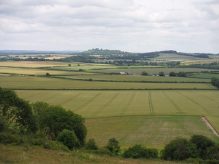
Danebury Hill, Wallop Brook Valley, from Broughton Down
SWC Walk 265 - Dean to Mottisfont & Dunbridge
Jun-16 • thomasgrabow on Flickr
swcwalks swcwalk265 banner walkicon 27354508504

Columbarium, St. Mary's, Broughton
SWC Walk 265 - Dean to Mottisfont & Dunbridge
Jun-16 • thomasgrabow on Flickr
swcwalks swcwalk265 walkicon 27932839806
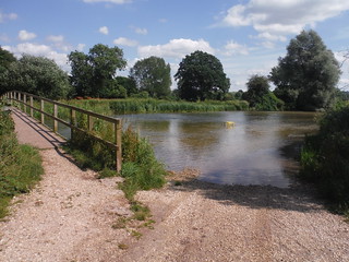
Swimming Spot by River Test Bridge, Houghton
SWC Walk 265 - Dean to Mottisfont and Dunbridge
Jun-16 • thomasgrabow on Flickr
swcwalks swcwalk265 walkicon 27353504213

Lane towards Lower Eldon Farm
SWC Walk 265 - Dean to Mottisfont and Dunbridge
Jun-16 • thomasgrabow on Flickr
swcwalks swcwalk265 walkicon 27932620076

Clarendon Palace remnants
SWC Walk 265 - Dean to Mottisfont and Dunbridge (Alternative Start from Salisbury)
Apr-17 • thomasgrabow on Flickr
swcwalks swcwalk265 walkicon 34048688641
| Length | 27.7 km (17.2 mi), with 438/451m ascent/descent. For a shorter walk see below Walk Options. |
|---|---|
| Toughness | 7 out of 10, with 6 ½ hours walking time. For the whole outing, including trains, sights and meals, allow at least 11 ½ hours. |
| Walk Notes |
This walk explores woods and rolling chalk hills in the Dun, Wallop Brook and Test Valleys of remote West Hampshire. Rising out of the Dun Valley through varied woods and along field boundaries and farm tracks (some tarmacked), the walk takes on a very different aspect upon approaching the steep sided chalk downs near Broughton, with splendid views north east across the Wallop Brook valley. After lunch in Broughton you follow the rim of the wide valley south easterly to cross the meadows of the Test River, Hampshire's longest and finest chalk stream. The Test – popular with swimmers in the summer – is a prominent feature of the afternoon, as its several arms are crossed twice.
A shorter route, cutting out parts of the afternoon, is described.
|
| Walk Options |
A Shortcut reduces the walk by 5.1 km (3.2 mi), the ascent/descent by 111m and the rating to 5/10. |
| Maps | OS Explorer: 131 (Romsey, Andover & Test Valley)
OS Landranger: 184 (Salisbury & The Plain) and 185 (Winchester & Basingstoke) |
| Travel | Dean Station, map reference SU 256 270, is 12 km east south east of Salisbury, 22 km north west of Southampton, 39m above sea level, and in Wiltshire, right on the boundary with Hampshire; Mottisfont & Dunbridge Station, map reference SU 318 261, is 6 km east of Dean Station, 26m above sea level and in West Hampshire. Both are on the Bristol Temple Meads to Southampton Central (via Salisbury) Wessex Main Line. Journey times to Dean are from 108 minutes Monday to Saturday (hourly service in each direction: either changing at Salisbury or at Southampton Central) and from 120 minutes Sundays. Journey times from Mottisfont & Dunbridge are from 110 minutes Monday to Saturday and from 118 minutes Sundays. Buy a Mottisfont & Dunbridge return. Saturday Walkers’ Club: Take a train no later than 9.20 hours. |
| Lunch |
Salisbury Start
Main Walk
|
| Tea |
The Mill Arms Inn Barley Hill, Dunbridge, Romsey, Hampshire, SO51 0LF (01794 340 401). The Mill Arms is a 19th century inn with flagstone floors, oak beams, open fire, conservatory and a three-tiered garden, 50m beyond the station.
|
| Profile | |
|---|---|
| Help Us! |
After the walk, please leave a comment, it really helps. Thanks! You can also upload photos to the SWC Group on Flickr (upload your photos) and videos to Youtube. This walk's tags are: |
| By Train |
Out (not a train station) Back (not a train station) |
| By Car |
Start Map Directions Return to the start: Finish Map Directions Travel to the start: |
| Amazon | |
| Help |
National Rail: 03457 48 49 50 • Traveline (bus times): 0871 200 22 33 (12p/min) • TFL (London) : 0343 222 1234 |
| Version |
Sep-24 Thomas G |
| Copyright | © Saturday Walkers Club. All Rights Reserved. No commercial use. No copying. No derivatives. Free with attribution for one time non-commercial use only. www.walkingclub.org.uk/site/license.shtml |

Walk Directions
Full directions for this walk are in a PDF file (link above) which you can print, or download on to a Kindle, tablet, or smartphone.
This is just the introduction. This walk's detailed directions are in a PDF available from wwww.walkingclub.org.uk