East Grinstead to Wivelsfield or Sheffield Park walk
Long walk through area of bluebell-rich woodland then heathery commons, or shorter walk and return by steam train

Garden House and Pond of Broadhurst Manor
SWC Walk 27 - East Grinstead to Wivelsfield or Sheffield Park
Apr-18 • thomasgrabow on Flickr
swcwalks banner swcwalk27 41757616492
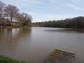
Largest in Chain of Fishing Ponds north of Horsted Keynes
SWC Walk 27 - East Grinstead to Wivelsfield or Sheffield Park
Apr-18 • thomasgrabow on Flickr
swcwalks walkicon swcwalk27 26930932387
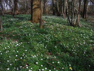
Wood Anemones in Sandpits Wood, Horsted Keynes
SWC Walk 27 - East Grinstead to Wivelsfield or Sheffield Park
Apr-18 • thomasgrabow on Flickr
swcwalks walkicon swcwalk27 39991457370
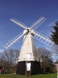
Chailey Windmill
SWC Walk 27 - East Grinstead to Wivelsfield or Sheffield Park
Apr-18 • thomasgrabow on Flickr
swcwalks walkicon swcwalk27 27930758748

Multi-Stemmed Birch Tree in Memorial Common part of Chailey Common
SWC Walk 27 - East Grinstead to Wivelsfield or Sheffield Park
Apr-18 • thomasgrabow on Flickr
swcwalks walkicon swcwalk27 41798592851
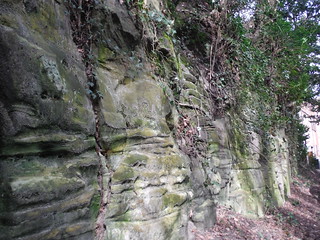
Sandstone bluff, Hermitage Lane - East Grinstead
SWC Walk 27 - East Grinstead to Wivelsfield or Sheffield Park
Apr-18 • thomasgrabow on Flickr
swcwalks swcwalk27 39991647100

Sandstone bluff, Hermitage Lane - East Grinstead
SWC Walk 27 - East Grinstead to Wivelsfield or Sheffield Park
Apr-18 • thomasgrabow on Flickr
swcwalks swc27 swcwalk27 41082303724
| Length |
31.9 km (19.8 mi), with 453/532m ascent/descent. For a shorter walk see below Walk Options. |
|---|---|
| Toughness |
8 out of 10, with 7 ½ hours walking time. For the whole outing, including trains, sights and meals, allow at least 10 hours. |
| Walk Notes |
This route in the East/West Sussex boundary lands descends from East Grinstead into the Upper Medway Valley and past Weir Wood Reservoir and then meanders through an undulating landscape of hills, streams, ponds, heaths and mixed woodland, rich in bluebells and wood anemones in season. For the most part, it largely shadows the course of The Bluebell Line steam railway, and lunch is either in tranquil Horsted Keynes or in Scaynes Hill, near the (Sussex) Ouse River. Later you pass through several parts of the large Chailey Common heathlands and continue westbound through flatter ground – mostly pastures with fine South Downs Views – to Burgess Hill (for Wivelsfield station).
|
| Historical Note |
This walk is a re-imagining of one originally devised by AJ Kennedy in 2007. His walk was from Forest Row (bus only) to Sheffield Park (expensive steam train only). Due to the awkward public transport and early last train, it was rarely used. This rewritten and extended walk now starts and finishes at train stations. This does make it quite long, so there are several options (three buses and one heritage steam train) to shorten the walk. The Bluebell Line has been extended since 2007, so it is now possible to walk from East Grinstead to Sheffield Park, and return by steam train. |
| Walk Options |
A diversion along a permissive path along the Weir Wood Reservoir’s dam and past the Water Works avoids a mud and flood prone footpath north east of the reservoir; see the route map for details.
|
| Maps |
OS Explorer: 135 (Ashdown Forest)
|
| Travel |
East Grinstead station, map reference TQ 388 382, is 43 km south south east of Charing Cross and 122m above sea level and in West Sussex. Wivelsfield station, map reference TQ 320 200, is 19 km south east of East Grinstead and 43m above sea level; Sheffield Park station, map reference TQ 403 236, is 15 km south of East Grinstead and 22m above sea level; both are in East Sussex.. East Grinstead station is on the East Grinstead branch of the Oxted Line from London Victoria (journey time from 60 minutes, at least hourly every day). Wivelsfield station is on the Brighton Main Line, with frequent services to Victoria and London Thameslink stops (journey time from 51 minutes). Sheffield Park station is the southern terminus of the Bluebell Railway from East Grinstead (journey time 40 minutes). Buy an East Grinstead return, you then may have to buy an additional single from Wivelsfield to East Croydon. Saturday Walkers' Club: Take the train closest to 9.00 hours. |
| Lunch |
The Green Man The Green, Horsted Keynes, Haywards Heath, West Sussex, RH17 7AS (01825 790 656). The Green Man is located 13.7 km (8.5 mi) into the walk. A Greene King pub.
|
| Tea |
The Sloop Inn As above. Tea (Wivelsfield):
Tea (Sheffield Park):
|
| Profile | |
|---|---|
| Help Us! |
After the walk, please leave a comment, it really helps. Thanks! You can also upload photos to the SWC Group on Flickr (upload your photos) and videos to Youtube. This walk's tags are: |
| By Train |
Out (not a train station) Back (not a train station) |
| By Car |
Start RH19 1EB Map Directions Return to the start: Finish RH15 0QF Map Directions Travel to the start: |
| Map Walk | This walk requires an OS map and a compass or GPS for navigation. You can print out OS maps using the link above. |
| Amazon | |
| Help |
National Rail: 03457 48 49 50 • Traveline (bus times): 0871 200 22 33 (12p/min) • TFL (London) : 0343 222 1234 |
| Version |
Apr-24 Thomas G |
| Copyright | © Saturday Walkers Club. All Rights Reserved. No commercial use. No copying. No derivatives. Free with attribution for one time non-commercial use only. www.walkingclub.org.uk/site/license.shtml |


Walk Directions
Full directions for this walk are in a PDF file (link above) which you can print, or download on to a Kindle, tablet, or smartphone.
This is just the introduction. This walk's detailed directions are in a PDF available from wwww.walkingclub.org.uk