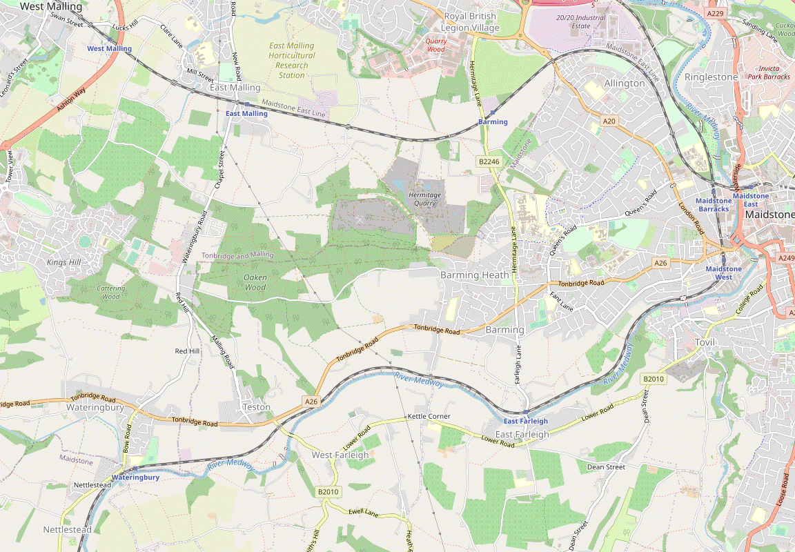
East Malling to Maidstone walk
Extensive orchards and two fine medieval bridges across the River Medway.
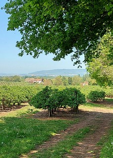
View North West with orchards and North Downs swcwalks swcwalk337
May-21 • nightingale51 on Flickr
swcwalks swcwalk337 51219186037
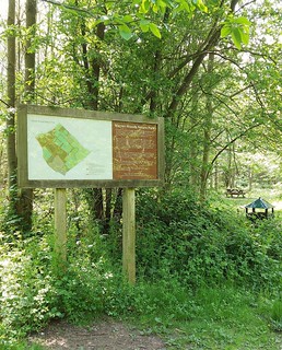
Warren Woods Nature Reserve East Malling swcwalks swcwalk337
May-21 • nightingale51 on Flickr
swcwalks swcwalk337 51220095183
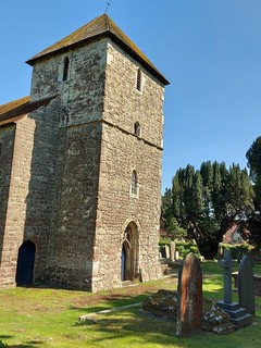
St Mary the Virgin Gibbs Hill swcwalks swcwalk337
May-21 • nightingale51 on Flickr
swcwalks swcwalk337 51220109508

Same foal with mum close by Meadway Valley Walk Wateringbury
May-21 • nightingale51 on Flickr
swcwalks swcwalk337 51219862471
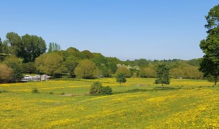
Meadway Valley Walk with Meadway River swcwalks swcwalk337
May-21 • nightingale51 on Flickr
swcwalks swcwalk337 51220967430
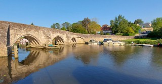
Farleigh Bridge East Farleigh swcwalks swcwalk337
May-21 • nightingale51 on Flickr
swcwalks swcwalk337 51219143537
| Length |
Main Walk, from East Malling: 19½ km (12.1 miles). Four hours 30 minutes walking time. For the whole excursion including trains, sights and meals, allow at least 9 hours. Longer Walk, from West Malling: 21¾ km (13.5 miles). Five hours walking time. Circular Walk, from East Malling: 18 km (11.2 miles). Four hours 15 minutes walking time. Near-Circular Walk, East to West Malling: 20¼ km (12.6 miles). Four hours 45 minutes walking time. Longer Circular Walk, from West Malling: 22½ km (14.1 miles). Five hours 20 minutes walking time. Short Circular Walk, omitting the Medway: 11¾ km (7.3 miles). Two hours 35 minutes walking time. |
|---|---|
| OS Map |
Explorer 148. East Malling, map reference TQ702569, is in Kent, 6 km W of Maidstone. |
| Toughness |
4 out of 10 (5 for the Longer Circular Walk, 2 for the Short Circular Walk). |
| Features |
East Malling (pronounced Mauling) is the site of a major Horticultural Research Institute, established in 1913 to support local fruit growers. Its research on plant culture led to the widely-adopted modern practice of using carefully selected dwarf rootstocks to produce a compact fruit-laden bush, as seen on the extensive orchards along the route: mainly apples but also pears, cherries and plums. Less appealingly the first part of the walk also has stretches through coppiced woodland which might be muddy, particularly if the ground has been churned up by recent tree work. The middle section of the walk mixes stretches alongside the River Medway with short excursions into the low hills on either side, with the first of these taking you to a highly-rated pub in West Farleigh for lunch. There are four bridges on this rural stretch of the Medway and those at Teston (pronounced Teestun) and East Farleigh are splendid examples of medieval design and craftmanship, with the latter claiming to be “the Finest Bridge in Southern England”. The final part of the walk is along a stretch of the Medway revitalized as the Maidstone Millennium River Park, into the county town of Maidstone. There are opportunities to explore the shops and eateries in the largely-pedestrianised town centre on the way to one of its three railway stations. |
| Walk Options |
In 2022 directions were added for a Circular Walk back to East Malling, together with link routes to its larger neighbour West Malling. The outward link route simply joins the two stations and so also provides a Longer Walk to Maidstone. The return route goes past sports pitches on the fringes of Kings Hill (a residential and business development on the site of the former RAF West Malling airfield) and then Warren Woods Nature Park. The longer ending to West Malling also takes in Manor Park Country Park (the remnants of an 18thC estate), with a possible short detour to view St Leonard's Tower. These outward and return legs are in the form of a Figure-of-8 centered on the intriguingly-named North Pole pub on Red Hill, so it is also possible to do a Short Circular Walk from West Malling. Several short cuts are included in the walk directions. In the morning you could save 1½ km by omitting the loop via Nettlestead, which would be worth considering if you missed a train and wanted to catch up a group which started earlier. Shorter alternative endings have also been included to all three destinations. The walk routes go past a couple of stations on the Medway Valley branch line and in theory you could devise a shorter walk by starting from Wateringbury or ending at East Farleigh. However, they have not been specifically listed here because an integrated set of shortish Medway Valley walks is already available in this walk's companion, the Wateringbury Circular walk (#336). |
| Transport |
West Malling and East Malling are adjacent stations on the Maidstone East line. There are hourly services from both Victoria (daily) and Charing Cross (Mon–Sat) along this line (each taking 53 minutes to West Malling), but only the Victoria trains call at East Malling, three minutes later. The most flexible ticket is a return to Maidstone stations, which would also be valid for returning via Paddock Wood on the Medway Valley line if you decided to abandon the walk at Wateringbury or East Farleigh†. For the circular walks a return to East Malling (or West Malling for that option) would be cheaper. † A Maidstone return might also be accepted for returning in the other direction from these stations, although you would definitely need to pay a “Plus High Speed” supplement if you connected with those trains at Strood. There is a half-hourly bus service along the A26 at Wateringbury and Teston. There is also an infrequent service (Mon–Sat) through West Farleigh, with the nearest bus stop on Ewell Lane being about 300m from the lunch pub. If driving, there is no car park at East Malling station but parking is available in nearby residential streets after 10.30am Mon–Fri and all day weekends. The station car park at West Malling costs around £6 Mon–Fri, £4 Sat, £3.50 Sun & BH (2024). |
| Suggested Train |
Take the train nearest to 10:00 from Victoria to East Malling for the walks starting there. If doing one of the Longer Walks from West Malling, take the train half an hour earlier (from Victoria or Charing Cross). |
| Train Times |
|
| Timetables |
|
| River Levels |
|
| Lunch |
The first pub passed (and the suggested place after 5½ km on the Short Circular Walk) is a “traditional English freehouse pub and restaurant” on Red Hill, the North Pole (01622-812721). On the longer walk options another possible early stop (weekends only) is The Railway pub (01622-812911) near Wateringbury station, but the suggested lunch pub is the up-market Tickled Trout (01622-814717) in West Farleigh, after 10¼ km (12½ km from West Malling). This refurbished pub has an outdoor patio and beer garden, and serves freshly-prepared seasonal food all day. |
| Tea |
In Maidstone there are plenty of pubs, cafés and coffee shops tucked away in the streets, alleyways and shopping malls making up its pedestrianised town centre, some with outdoor seating. There are far too many eateries to list in full, but the directions go via two places in the same arcade which might tempt you: the Italian Vesuvius Café (01622-296767) and the French Café Frédéric (01622-297414). A little further on there is a mall (Fremlin Walk) with a Costa and a Pâtisserie Valerie. The nearest pub to Maidstone East station is a JD Wetherspoons, The Society Rooms (01622-350910). In the station itself there is a small buffet on Platform 1. For the other walk options there is more choice on the West Malling ending: a café in Manor Park (usually open to 4pm Mon–Fri, 5pm weekends) plus several coffee shops in the town, with a Costa (01732-522934; open to 6pm Mon–Sat, 5pm Sun) in the High Street more likely to be open at the end of a walk than The Hungry Guest café (01732-870766; open to 5pm Mon–Sat, 4pm Sun) next door or Rose's Coffee & Juice (07950-799137; open to 5pm Mon–Fri, 4pm weekends) in Swan Street. For stronger fare the town has a couple of places describing themselves as gastropubs: the Five Pointed Star (01732-842192) in the High Street and The Swan (01732-521910) in Swan Street; there is also the more traditional Joiners Arms (01732-840723). In contrast the only convenient refreshment place on the East Malling ending is the “quintessentially English” King & Queen pub (01732-842752). |
| Profile | |
|---|---|
| Help Us! |
After the walk, please leave a comment, it really helps. Thanks! You can also upload photos to the SWC Group on Flickr (upload your photos) and videos to Youtube. This walk's tags are: |
| By Train |
Out (not a train station) Back (not a train station) |
| By Car |
Start ME19 6AJ Map Directions Return to the start: Finish ME14 1QN Map Directions Travel to the start: |
| Amazon | |
| Help |
National Rail: 03457 48 49 50 • Traveline (bus times): 0871 200 22 33 (12p/min) • TFL (London) : 0343 222 1234 |
| Version |
Sep-24 Sean |
| Copyright | © Saturday Walkers Club. All Rights Reserved. No commercial use. No copying. No derivatives. Free with attribution for one time non-commercial use only. www.walkingclub.org.uk/site/license.shtml |


Walk Directions
Click the heading below to show/hide the walk route for the selected option(s).


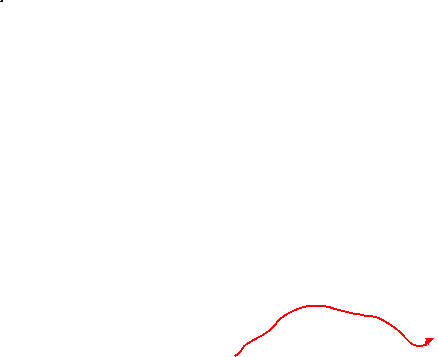


 Walk Map
©
Walk Options ( »Maid. | Circ. )
Click on any option to show only the sections making up that route, or the heading above to show all sections.
- Main Walk, from East Malling (19½ km)
Walk Directions
Click on any section heading to switch between detailed directions and an outline, or the heading above to switch all sections.
If you are doing a version of this walk from East Malling station, start at §B.
- West Malling Station to East Malling Station (2¼ km)
- Leave the station on its north side. Head east on Lucks Hill for 300m, then take a footpath on the right along field edges. Continue along Mill Street into East Malling, optionally detouring through its recreation ground at the end. Go through the churchyard at the end of Church Walk and turn right onto a footpath leading to a level crossing over the tracks at East Malling station.
- Arriving from London, do not cross the footbridge but leave the station by an exit near the London end of Platform 2. Go down the short approach road and turn right onto a road (Lucks Hill). Cross over carefully and go along the pavement on its left-hand side, soon passing under the A228 dual carriageway.
-
Ignore a path branching off to the left. Shortly afterwards go back across the road with great care (there is restricted visibility on the inside of this left-hand bend) onto what looks like a private farm lane with a vehicle barrier, but is also a public footpath. Just before the lane leads into a field, turn left onto a narrow tree-lined path, the continuation of the right of way.
- If this path is overgrown you might prefer to walk along the broad field margin (as many locals do). The two paths merge in 125m.
- After the footpath emerges into a second field continue along its edge to a lane (Broadwater Road). Cross over onto the continuation of the footpath, just off to the right. Follow this fenced path between farm fields for 400m, parallel to the railway off to the right. At the end bear slightly left onto a track leading out between houses to a lane (Mill Street).
-
Turn right and follow this quiet street round a bend to the left, passing some attractive cottages. In 200m you pass a converted mill on the right and cross East Malling Stream?. In a further 300m, at the end of the houses on the left, turn left through a wooden gate into the corner of East Malling's recreation ground.
- Alternatively you can simply carry on to the end of Mill Street and go straight across New Road onto Church Walk (a slightly more direct route).
- For the suggested route head towards the left-end corner of some tennis courts off to the right. Go alongside them and then bear slightly right to leave the recreation ground through the car park for the King & Queen pub, passing its beer garden on the right. Cross New Road in front of the pub onto a patch of grass containing the War Memorial and continue along Church Walk, the cul-de-sac opposite Mill Street.
- At the end of this short street keep ahead on the path through the churchyard, passing to the right of St James the Great church?. At the far end go past metal barriers and immediately turn right at a footpath junction. In 200m you reach a level crossing over the railway tracks, with the platforms of East Malling station just off to the right.
- East Malling Station to the North Pole (pub) (3¼ km)
-
- If starting the walk here, go up to the level crossing over the tracks at the Maidstone end of the platform.
- Cross the tracks and follow the footpath to The Rocks Road. Continue on the footpath a little way off to the right, heading south along field edges. At the far end turn right onto Sweets Lane, then turn sharp left at a crossroads onto a footpath through Oaken Wood. In 800m turn right at a footpath junction to go around the western edge of the wood. Turn right onto Barming Road and left onto Red Hill to come to the North Pole pub.
-
Starting from East Malling Station
-
If arriving from London to start the walk here, the suggested route is to take the path at the Maidstone end of the platform to a level crossing over the railway tracks (ie. ignore the steps down to the road at the London end, the main exit).
- If you were at the London end of the train you could take the main exit, turn left onto the road to go under the railway bridge and immediately turn left again into The Rocks Road. In 300m turn right onto a signposted footpath and resume the directions at [?].
- Go through a white-painted wooden gate and cross the tracks carefully (bearing in mind that non-stop trains will be speeding through the station). Continue on the enclosed footpath between houses and paddocks, heading S. At the end turn right onto a lane (The Rocks Road), briefly heading back towards East Malling. In 50m turn sharp left into a driveway, signposted as a footpath.
- After passing the property (a pair of converted oast houses) keep right. Go past a wooden fieldgate onto a long straight path heading S, initially with a tall hedge on the right. Later the path switches to the other side of the hedge, swings right and left, and comes out onto a minor road (Sweets Lane).
- Turn right and go along this quiet lane for 250m. Just before reaching a crossroads turn sharp left past some concrete vehicle barriers onto a signposted footpath through coppiced woodland.
- In 300m the path turns half-left in front of a boundary hedge, with bungalows on the other side. Follow the path round to the right to continue alongside the properties. At the end of the development the path bears slightly left and resumes its long straight course through the coppice, heading S.
- In 300m turn right at a signposted path crossing onto a new public footpath (not shown on older OS maps). This route takes you to the western edge of the wood, where some mature trees (standards) have been left amid the coppice. The path swings round to the left at the corner of the wood and soon straightens out. Keep ahead where a couple of tracks merge from the left and follow the path out to a lane (Barming Road).
- Turn right onto the lane, ignoring the continuation of the new footpath opposite. In 200m turn left at the T-junction with a main road (Red Hill) and go along its broad grass verge for 100m, passing the beer garden of the North Pole pub? on the left. This is the suggested lunch stop on the Short Circular Walk and a possible early stop on the others.
- The North Pole to Wateringbury (Mill Oast House) (2 km)
- Go across Red Hill onto Teston Road. In 250m turn left onto a footpath heading south-west and then south through Hoath Wood. Continue past orchards and the grounds of Wateringbury Place to the A26 (Tonbridge Road). Cross the main road and go down Love Lane to Mill Oast House.
- Cross the main road carefully and go along Teston Road, the cul-de-sac opposite the entrance to the pub's car park. In 250m, after the last house on the left, turn left at a footpath signpost onto another long straight path through coppiced woodland, heading SW.
- In 300m another footpath merges from the right by the remains of a large fallen tree. Carry on in much the same direction for 50m, ignoring a side path to the left and another to the right. The path then splits in front of another large tree, where you fork left. Follow this woodland path gently downhill for 150m, heading S.
-
At the edge of the wood go past some low posts and continue on a fenced path with a large orchard on your right. The path curves right and then splits in front of a small wood, where the suggested route is to fork left into the wood.
- If this path is blocked or marked “Private” simply go around the outside of the wood; the two routes rejoin after 100m. At the time of writing there was no waymarking to show which route was the right of way, but the woodland path is clearly well used.
- On the far side the woodland path comes out past a metal fieldgate. Bear left onto a grassy path between hedges, heading S again with orchards on both sides and views of the Medway Valley ahead on the left. At the end of the hedge the footpath continues as an enclosed path with a chainlink fence on the right, behind which a belt of trees shields the extensive grounds of Wateringbury Place.
-
At the end of this long straight path keep ahead along a driveway past some houses to the A26, where there is a Local History Society plaque about PLUTO? on the garden wall.
If you want to abandon the walk there are frequent buses to Maidstone or Tonbridge along this road. The nearest stops are 250m away, on the left.
- Cross the main road carefully and take the minor road opposite (Love Lane), which soon drops downhill. At the bottom of the dip it crosses a stream (coming from a waterfall in the garden on the right) in a culvert and comes to a cluster of converted oast houses, with a byway signposted off to the left.
- Mill Oast House to Medway Wharf Marina (2½ • 1 km)
-
For the main route, go up Love Lane to the mill pond and turn left onto a footpath heading south to the B2015 at Nettlestead. Take the path opposite through the churchyard and join a footpath going down across the railway to the river. Turn left onto the riverside path, joining the Medway Valley Walk (MVW). In 800m cross the river on Bow Bridge.
- For a more direct route turn sharp left onto a byway heading east along the side of a small valley to the B2015 (Bow Road). Turn right and follow the road downhill. Just past the entrance to Wateringbury station turn left and cross the river on Bow Bridge, joining the Medway Valley Walk (MVW).
-
Main route (2½ km)
- Ignore the byway and stay on Love Lane as it bends right and goes up a slope to an old mill pond. Veer left uphill, passing Brooms House? (with blue plaque) on the left. At the top of the slope the lane straightens out, heading S with views across fields on the left to the Medway Valley.
- In 300m go through a couple of gates by the last group of houses onto a footpath which zig-zags right and left, then continues along the left-hand edge of some large farm fields for a further 300m. In the bottom corner of the last field go past metal vehicle barriers and bear right past a second set onto an enclosed path, with a housing estate behind garden fences on the left.
- Continue past Nettlestead's recreation ground and more houses to reach the B2015. Cross the road carefully and take the unmarked path directly opposite, which curves to the right and leads into the north-western corner of a churchyard. Go past the church tower and turn left to come to the west door of St Mary the Virgin?, which is worth visiting if open.
- Continue on the path heading away from the door, which turns left on the edge of the churchyard and leads to an exit in its south-eastern corner. Go down a few steps, through a stone archway and follow a potentially muddy path downhill, with glimpses of Nettlestead Place? and its gardens through the trees on the right.
- At the bottom cross the railway tracks and turn left onto the riverside path, joining the Medway Valley Walk? (MVW) and heading N. In 500m the path crosses a stream on a wooden footbridge and the final 300m is on a driveway between a caravan park and pleasure craft moored on the river.
- Go past a wooden fieldgate and take the left-hand of two driveways up a slope past the back of the (closed) Riverside Restaurant. At the top turn right to go across the river on Bow Bridge, passing the entrance to Medway Wharf Marina (and its Ramblers Rest Café) on the right.
-
Short cut (1 km)
- Turn sharp left off Love Lane onto the byway, a path which curves round to the right above a picturesque valley containing an old orchard. At the end follow the path down to the left and climb up a lane on the other side of the valley to the B2015 (Bow Road).
- Turn right onto the road and follow it downhill, crossing over at the zebra crossing along the way. At the bottom of the slope go past the entrance to Wateringbury station and turn left into the minor road (Bow Hill) opposite The Railway pub.
- Go over the level crossing and past the entrance to Bow Bridge Marina, joining the Medway Valley Walk? (MVW). Continue …
- Medway Wharf Marina to West Farleigh (2½ km)
- Follow the MVW on the south side of the river as far as Tutsham Hall: across water meadows, along the bottom edge of Waregrave's Wood and up across a field. At Tutsham Hall take a footpath heading east across fields and through a belt of trees. Veer right to reach the pub on the B2010 in West Farleigh.
- Just past the entrance to the marina turn left off the road by a MVW signpost. Go over an awkward stile, across a patch of grass and through a metal gate into a water meadow, a potentially boggy area. Follow a grassy path heading E across the meadow (possibly partioned with temporary fencing) towards a line of trees 250m away.
- In the trees go through a partly-concealed metal kissing gate and continue across another meadow, slightly to the left and gradually approaching a boundary fence on the left. A plank footbridge gets you across a boggy area and the path continues alongside the fence. A section of boardwalk and another footbridge takes you into Waregrave's Wood, close to the river on your left.
- Follow the woodland path along its bottom edge, negotiating one or two streams along the way. At the end leave the wood through a metal side gate and go up a small slope into a large field. Follow a faint grassy path curving gently up to the right, passing a footpath marker post by an isolated tree and with increasingly fine views of the river valley as you climb.
- On the far side of the field go through a metal side gate and straight across a parking area in front of a barn conversion. Continue on a tarmac driveway going over a small rise and then past some farm buildings and cottages. Opposite the ivied Tutsham Hall? the MVW veers off to the left, through a wooden gate next to the cattle grid on the manor house's approach road.
- For the full walk follow the drive round to the right in front of a large barn, leaving the MVW. At the end of the buildings turn left onto a long straight grassy path between fences, signposted as a footpath. Continue through a gate and in much the same direction across two fields. As the ground ahead drops away you will be able to see the exit from the second field, a metal gate in the tree boundary.
- Go through this gate and along a short grassy path towards a pair of metal gates. Go through the right-hand gate and up a slope into a field, with a striking Queen Anne house ahead on your right. If there is no clear path aim for the tall hedge to the left of this house, behind which is the beer garden of the suggested lunch pub.
- In front of the hedge veer right onto a broad grassy path coming up from the left. At the top of the field go out through a gate in the boundary wall onto a lane (Lower Road). The Tickled Trout is the first building on the left, while the small crescent-shaped patch of grass opposite Smiths Hall? makes a convenient picnic spot.
- West Farleigh to Teston Bridge (1½ • 1 km)
-
For the main route, turn right out of the pub and keep right at a junction. Take a byway on the right uphill past some farm buildings, then turn left onto a footpath going downhill across fields towards the river. Turn right onto a lane and follow it out to the B2163. Cross the river on Teston Bridge.
- For a more direct route, take the footpath heading north-west from the pub to join the lane leading to the B2163.
-
Main route (1½ km)
- Turn right out of the pub and follow the road past Smiths Hall. Keep right at a triangular junction, signposted to Yalding. Where the road bends left after 100m veer right onto a tarmac driveway and follow this byway uphill past paddocks to a cluster of modernised farm buildings.
- At the end of the tarmac keep ahead on a gravel drive past the last of these properties. Go out through a metal fieldgate into a large field and immediately turn right to go along its edge, gently downhill with a hedge on your right and views ahead across the Medway Valley.
- In the field corner go through a small metal gate to the right of the wide gap ahead, in order to go down the left-hand edge of the next field. In 50m keep ahead at a footpath signpost in the wire fence, crossing over your outward route.
- In the bottom corner go through a metal kissing gate and turn half-right to go diagonally across a meadow, aiming slightly to the right of a prominent white building 1 km away, Barham Court?.
- In the far corner turn right onto a tarmac lane (via another kissing gate if you want to avoid a cattle grid), rejoining the MVW. It goes past the white-painted row of Mill Cottages and then some more houses in a dip, with a large pond on the right.
- The lane crosses a stream flowing from the pond towards the ruins of Tutsham Oil Mill?, then winds its way back uphill past some large old trees. Follow it round a couple of bends to a T-junction with the B2163.
-
Direct route (1 km)
- Turn right out of the pub and retrace your steps through the gate into the field below Smiths Hall. Follow a clear grassy path gently downhill across two fields, going through a metal kissing gate in the tree boundary between them.
- At the bottom of the second field go out through a side gate and keep ahead on a lane, rejoining the MVW. Follow the lane round a right-hand bend and out to a T-junction with the B2163.
- At the T-junction cross the main road carefully and go up a few steps in the bank opposite. Do not go through the gate ahead but turn sharp left onto a permissive path in the belt of trees beside the road. This avoids a bit of awkward road walking but you soon have to rejoin the B2163 in front of the medieval Teston Bridge?. Cross this narrow road bridge carefully, using the refuges when necessary to avoid the traffic.
- Teston Bridge to East Farleigh Station (3 km)
- Turn right onto the riverside path on the north bank of the Medway. Follow it for 3 km, past Barming Bridge and on to East Farleigh. Unless you decide to stay on the towpath for the start of the next section, go out onto Farleigh Lane between the station and the medieval bridge.
- To head for Maidstone go over a stile on the right onto a broad strip of grassland dotted with trees, part of a long linear area designated as the Maidstone Millennium River Park?. On this 2 km stretch there are occasional gates to negotiate and wooden footbridges to take you across side streams. Eventually you go straight across a track at Barming Bridge?.
-
Continue alongside the river on the signposted Medway Towpath?. In 750m you can see East Farleigh church directly ahead on the far bank as the river curves round to the left. The path goes past caravan sites and a raised footbridge takes you across the entrance to a small marina as you approach the medieval East Farleigh Bridge?.
- For variety the suggested route leaves the river for the next 2 km but you could simply remain on the towpath, going under a low arch in the bridge and past the refurbished East Farleigh Lock?. There are gardens sloping down to the river on the opposite bank, then a long stretch of woodland before the main route rejoins from a byway on the left. If you take this short cut (saving 200m) resume the directions at [?] in §H.
-
For the suggested route, leave the towpath 60m before the bridge, where there is a gap in the fence with a large sign advertising a nearby pub. Go up a few steps and follow a series of FOOTPATH► signs to go out between converted buildings to a road (Farleigh Lane). Turn left onto the road, towards a level crossing between the two platforms of East Farleigh station.
- If you want to curtail the walk, trains to Paddock Wood leave from Platform 1, on the right. For trains to Maidstone and Strood from Platform 2, cross the tracks and turn left (or use the footbridge). If you have a long wait, The Victory pub is just up the road.
- East Farleigh Station to Maidstone (Lockmeadow Bridge) (3½ km)
- Go over the level crossing and turn right onto a footpath opposite The Victory pub. Follow it past The Oast and then fork right onto a footpath heading north-east. At the end take the byway on the right to return to the riverside path. Continue along the towpath to a new pedestrian footbridge by the Lockmeadow Entertainment Centre in Maidstone.
- Go over the level crossing and continue briefly up the right-hand side of Farleigh Lane. Opposite The Victory pub turn right through a wooden swing gate in the hedge onto a narrow and potentially muddy footpath.
-
This rather awkward path gradually drops back towards the railway line, then a short flight of steps takes you up to an easier path alongside the stone wall of a house (The Oast). At the end of the property follow the path round to the left and up to a path junction, marked by a telegraph pole with footpath waymarkers.
- Up ahead on the left refreshments might be available on summer weekends at Sonya's Tea Barn Bakery.
- To continue the walk fork right at the junction onto the driveway to a house, passing it on your left. Go through a side gate and continue along an unsurfaced track between hedges, climbing gently. In 150m a footpath merges from the left and the track levels off, with views across the Medway Valley as it heads NE directly towards Maidstone.
- In 500m you pass the first of some substantial properties on the left. In a further 200m, just before the track leads out onto a residential street at a bend, turn right onto a signposted byway and follow this track all the way downhill. At the bottom go under a railway bridge and turn left, rejoining the Medway Towpath.
- Bydews Wood is across the river at first, but the area gradually becomes more built up on both sides. In 800m you pass a girder footbridge connecting two of Maidstone's suburbs at Lower Fant. In the next 1 km an old industrial area has been revitalised with a succession of new riverside apartment blocks, somewhat reminiscent of London's Docklands.
- Eventually you pass the Lockmeadow Entertainment Centre on the left and come to an elegant new footbridge across the river, Lockmeadow Millennium Bridge?. There is a large metal sculpture The Stag? on the left and a fine view across the river to All Saints Church? and the Archbishop's Palace?.
- Lockmeadow Bridge to Maidstone Stations (1¼ • ½ km)
-
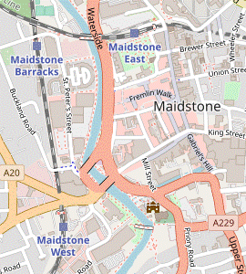 Unless you want to head directly to Maidstone West station (off to the left) cross to the other bank, go past the Archbishop's Palace and up the High Street. Take any route heading north through the town centre, eventually crossing Brenchley Gardens to their north-eastern corner to reach Maidstone East station.
-
To Maidstone East Station (1¼ km)
- Start by crossing the river on the footbridge and continue along the other bank, past the Archbishop's Palace and a mooring point for pleasure cruisers. In front of St Peter's Bridge take the path sloping up to traffic lights on the busy main road (Bishops Way).
- Cross Bishops Way and go up the High Street for 250m, passing a 19thC Russian Cannon?. Opposite the Town Hall? go through an archway into Market Buildings, passing an Italian café and a French bistro/pâtisserie in the Corn Exchange arcade on the right.
- At the end of the arcade turn right briefly into Earl Street by the Hazlitt Theatre, then turn left into another alley leading to Fremlin Walk. Turn left into this shopping mall, which has some refreshment places with outdoor seating at the far end.
- To complete the walk take an exit from the mall on the north side which comes out in front of Maidstone Museum?. Go past the right-hand side of the building and up a patch of grassland containing a memorial stone to the Battle of Maidstone?.
-
Make your way across Brenchley Gardens? to its top right-hand corner, with the station ahead. There is a side entrance directly onto Platform 1 (for trains to London) through a gap in the brick wall behind the small parking area. For the other platforms you would need to enter via the ticket hall.
- If you want to return on the Medway Valley line there is a signposted walkway across the river on the railway bridge to Maidstone Barracks station.
-
To Maidstone West Station (½ km)
- To head for this station without going into the town centre, continue along the riverside path past the Law Courts. Follow the path round to the left in front of St Peter's Bridge to join the main road (Broadway). Keep ahead at traffic lights and in 100m turn left by the War Memorial into Station Approach.
-
The station entrance is on the right. Trains to Paddock Wood depart from Platform 2 (on this side); cross the footbridge to Platform 1 for trains to Strood.
- Teston Bridge to the North Pole (pub) (2½ km)
- Go over the level crossing on the B2163 and turn left onto the A26. In 150m turn right onto a footpath leading to Teston church and turn left onto Church Street. In the centre of the village turn right onto Malling Road. In 500m fork right into an unsurfaced lane (Livesey Street). In 450m fork right onto a bridleway at North Lodge, then almost immediately turn left onto a new footpath through woodland. In 475m turn left onto a short link path leading back to Livesey Street and turn right to come to the North Pole pub on Red Hill.
- To head back to East or West Malling the suggested route (rather than continuing on the pavement) is to go through the gate on the left for a brief detour into Teston Bridge Country Park?: it has a refreshment kiosk and toilets in its car park, and there is a nice view of the medieval bridge from the riverside path. If you do this, leave through its vehicle entrance a little further up the road.
-
Go over the level crossing and turn left at the T-junction ahead onto the pavement alongside the A26. The continuation of the walk is a signposted footpath on the other side, 150m from this junction. If there is too much traffic to attempt a direct crossing of this wide main road, use the traffic island a little further on and double back along the pavement on the other side to the footpath.
- If you want to abandon the walk there are frequent buses to Maidstone or Tonbridge along the A26. The nearest stops are 100m past the footpath turning, just beyond the road junction ahead.
- Take the signposted footpath away from the A26, a narrow fenced path. In 50m go across a residential street onto its continuation, just off to the right. This brings you out onto Teston's small village green, with Ss Peter and Paul church? on the right.
- Veer left across the grass to the street on the other side and follow it out to a crossroads, with Teston Village Stores on the left. Turn right onto the main road (Malling Road), steadily uphill and soon passing an elegantly converted property emblazoned with lettering proclaiming its former existence as the Alfred Reader factory?.
- The turning off Malling Road is a further 400m away. After the pavement ends there is a slightly awkward stretch where you need to take care but in 75m you can escape into Fairlawn Close on the right, which runs parallel to the main road for 100m. Immediately after rejoining it fork right into Livesey Street.
- Go along this “Unsuitable for Motors” lane for 450m, with a few houses on the left and woodland on the right. After climbing gently for most of the way it dips down and splits in front of a wooden fieldgate with a sign for North Lodge.
- It looks as if you need to take the unappealing rutted track on the left (the continuation of Livesey Street, which does lead to the North Pole pub), but an inconspicuous blue waymarker confirms that you can fork right through the gate. Immediately after passing North Lodge turn left at a waymarker post onto a narrow path climbing through the trees, a new public footpath (not shown on older OS maps).
- In 125m keep ahead where another path merges from the right. In a further 350m, at the bottom of a small dip, turn left at a signposted junction onto another new footpath. This narrow path drops down, bends right and comes to a T-junction where you turn right, rejoining Livesey Street.
- Follow this track past an outbuilding and then the large gardens of some properties on the woodland edge. In 250m the track leads into the car park of the North Pole pub?, with the opportunity for a mid-afternoon refreshment stop before you repeat a short stretch of your outward route.
- The North Pole to Well Street (2½ km)
- Go across Red Hill onto Teston Road. In 600m turn right onto a bridleway going past Kings Hill Sports Park pavilion into Warren Woods Nature Park. Follow permissive paths through the wood to join a public footpath heading north along its western edge to a road junction. Keep ahead along a lane (Well Street) for 300m.
- … Go along this quiet lane for 600m, ignoring a footpath off to the left at the end of the houses. Shortly after passing another footpath on the left, and before reaching a concrete vehicle barrier across the lane, turn right onto a signposted bridleway.
-
Go past a jumble of vehicle-blocking rocks onto a path between hedges, passing some football pitches and continuing between Kings Hill Sports Park pavilion and its car park. Go straight across an access road onto a path into trees, entering Warren Woods Nature Park?.
The walk route follows a permissive path shown on the Nature Park's information panel. The woods are bounded by private land ostentatiously marked with “No public access or right of way” notices, but unless permission has been unexpectedly withdrawn the route described here should not present any problem.
- Just inside the wood fork left (leaving the bridleway, which takes a parallel route outside the wood). In 250m turn left at a T-junction, passing an information panel about the Nature Park and a small picnic area on the left. The woodland path goes through a dip and climbs back up the other side. At the top go through a metal kissing gate and turn right at a T-junction onto a long straight path near the western edge of the wood.
- The path comes out into the corner of a small open area, with wooden paling on the left marking the park boundary. Continue alongside the fence, all the way round to a path junction in the opposite corner. At this junction veer right onto a public footpath along the edge of the wood, with orchards off to the left.
- In 300m the path comes out at a road junction. Keep ahead on the “Unsuitable for HGVs” lane (Well Street) for a further 300m, passing more orchards on the left and some attractive properties on the right. Immediately after passing a large old house on the left there is an easily-missed gap in the hedge with a footpath signpost.
- Well Street to Manor Park Country Park (1½ km)
- Turn left off Well Street onto a footpath (and later a byway) leading to Broadwater Road. Turn left onto the road for a short distance and take the bridleway on the right leading to Lavenders Road. Cross the A228 and go straight ahead into Manor Park Country Park.
- To head for West Malling turn left through the gap in the hedge. Follow a broad grassy path across a large farm field, heading towards the buildings of Broadwater Farm in the distance. In 200m turn right at a path crossing with a yellow waymarker post. The path turns left almost immediately to resume its previous direction (as a byway), with an orchard on the right.
- The path goes past a row of tall trees screening the farm buildings and eventually joins a farm track leading out to a lane (Broadwater Road). Ignore the continuation of the track opposite and turn left onto the lane. In 75m, just after passing a house on the right, turn right onto a signposted bridleway. Follow it past the side of the property and then straight across a farm field.
- On the far side of the field the bridleway leads out to a lane (Lavenders Road). You will be joining this lane later in order to get across a busy main road (the A228), but the suggested route is to bear right onto a well-trodden parallel path along the field edge: this is a rerouted public footpath, shown as going across the field on older OS maps.
- In the field corner veer left through a gap and zig-zag left and right to join Lavenders Road. Cross the A228 on the road bridge and go along the lane for 150m, ignoring paths off to both sides. Where the lane bends right at a road junction go straight ahead through a side gate into Manor Park Country Park?.
- Manor Park to West Malling Station (2¼ • 1¼ km)
-
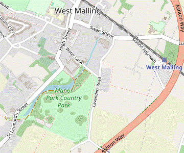 For the main route via the town, keep ahead through the parkland to come to the park café. Veer right and follow the waymarked ‘Lake Loop’ to the northern end of the lake. Turn left to cross a stream and go out to St Leonard's Street. Turn right and continue along West Malling's High Street. Turn right into Swan Street and go along it for 500m, then turn right again into Station Approach.
-
You can bypass the town centre by veering right inside the park and rejoining Lavenders Road at the far end of the parkland. Follow it to its T-junction with Swan Street and turn right to come to Station Approach.
-
You can bypass the town centre by veering right inside the park and rejoining Lavenders Road at the far end of the parkland. Follow it to its T-junction with Swan Street and turn right to come to Station Approach.
-
Main route (2¼ km)
- Inside the park keep ahead on a broad grassy path near the left-hand edge of the field (Chestnut Paddock), with a wire fence on your left. In 300m go through a metal kissing gate into the corner of the overflow car park and cut across it to come to the Manor Park Café, a possible refreshment stop.
-
Unless you want to detour to St Leonard's Tower? (250m away), head N away from the café on a surfaced path past picnic tables in Douce's Meadow. Take any of the paths through the trees on the left (one has a ‘Lake Loop’ waymarker) which go down to the Lake and turn right onto the lakeside path.
- For the detour, go across the main car park from the café and out along the access road. In 100m bear left onto a waymarked footpath past a row of cottages; the tower is directly ahead, across the main road. When returning you can join the start of the lakeside path from the access road.
- On the lakeside path there is a fine view of Douce's Manor? across the water. Keep left at path junctions to stay alongside the water. Where the lake narrows to a stream, there is a plank bridge across it which is the route into the town.
- For the route via the town cross the stream, go up steps in the bank opposite and follow the tree-lined path along the edge of Ice House Meadow. Leave the park through a gate and turn right onto St Leonard's Street.
- Follow the street round a couple of bends, passing St Mary's church? at the head of the wide High Street with its fine Georgian buildings. Some possible refreshment places are the Five Pointed Star and Joiners Arms on the left-hand side, and a Costa Coffee and The Hungry Guest cafés on the right.
- Turn right into Swan Street. Two more places are Rose's Coffee & Juice on the right, and The Swan pub/restaurant on the left. Further along this street you pass St Mary's Abbey? on the right, then Lavenders Road at the corner of its grounds.
- Continue along Swan Street for a further 150m. Just before the railway bridge turn right into the long approach road to West Malling station. At the left-hand end of the station building there is an entrance onto Platform 1, for trains to London.
-
Direct route (1¼ km)
- Inside the park veer right onto a grassy path near the right-hand edge of the field (Chestnut Paddock). In 150m go through a gate and keep ahead through the next field (Abbey Field).
-
In 200m bear right to leave the park through a gate in the tree boundary, rejoining Lavenders Road. Turn left onto the road, soon passing Water Lane on the left.
- If you miss this exit from the park there is another one down to the left, where you can turn right onto Water Lane to get back to Lavenders Road.
- Follow Lavenders Road all the way to its T-junction with Swan Street, towards the end passing the grounds of St Mary's Abbey? behind a high stone wall on the left.
-
Turn right and go along Swan Street for 150m.
…
- Well Street to East Malling Station (1¼ • ¾ km)
-
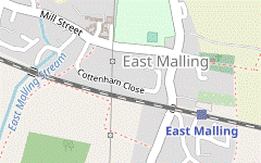 Continue briefly along Well Street and then bear right onto a footpath. For the main route via the town, follow the path under the railway embankment and past houses to Mill Street. Turn right to reach a pub at the crossroads in the town centre. To complete the walk go up the High Street to the station.
-
You can bypass the town centre by turning right off the footpath from Well Street before reaching the railway and going down Chapel Street directly to the station.
-
You can bypass the town centre by turning right off the footpath from Well Street before reaching the railway and going down Chapel Street directly to the station.
- To head for East Malling ignore the footpath and carry on along Well Street for 50m. Where the lane curves left, bear right into a driveway (which is also a public footpath). Follow this down a slope and past a few cottages.
- Continue past the right-hand side of a pond (at the head of East Malling Stream?) into a wooded area. After climbing gently above a series of small ponds for 200m, and at the end of a wire fence on your right, there is a waymarker post at a footpath junction.
-
Main route (1¼ km)
- Keep ahead at the path junction, now with an overgrown orchard on your right. In 200m the path comes to a junction in front of the railway line where you turn sharp left. Follow the path down a slope, under the railway and back up the other side.
- At the top go through a wooden kissing gate to continue on a wide fenced path between houses. In 75m go straight across a residential street and along the continuation of the footpath for a further 100m.
- At the end turn right onto Mill Street. Follow it for 300m into the centre of East Malling, where the King & Queen pub is on the left at the crossroads.
- To complete the walk turn right out of the pub, cross Mill Street and go up the narrow High Street for 200m.
- After passing under the railway bridge turn left into a side road to find the steps leading up to Platform 1 of East Malling station, for trains to London.
-
Direct route (¾ km)
- Turn right at the junction onto a long straight path, hemmed in between trees and a wire fence. In 300m the path emerges into the corner of a triangular field and you continue along its edge, with a hedge on your right.
- In the far corner go through a wooden kissing gate and along a path between houses to a road (Chapel Street). Turn left and follow the road downhill.
-
Just before it goes under the railway bridge at the bottom veer right across
…
- East Malling Stream has its source in Well Street and flows into the River Medway at Aylesford. There used to be six watermills along this short river.
- St James the Great, East Malling dates from the 11thC, with changes and additions made in the 14thC. It is listed Grade Ⅰ.
- The North Pole pub dates back to 1826 and its name may reflect the contemporary interest in Arctic exploration. In that year the Admiralty sanctioned one of the earliest attempts to reach the pole; the expedition led by the British naval officer William Parry reached 82°45′N in 1827, a record for the northernmost latitude which stood for 49 years.
- Operation PLUTO (Pipe Line Underwater Transportation of Oil, or Pipe Line Under The Ocean) was a World War Ⅱ project to supply fuel to the Allied forces in Normandy after D-Day. The pipeline at Wateringbury was part of an additional route via Dungeness to Boulogne, added as the troops advanced. It was a major engineering feat at the time but only partly successful, supplying just 8% of the fuel used in 1944-45.
- Brooms House was the home of the astronomer William Rutter Dawes (1799-1868). Affectionately nicknamed “eagle eye Dawes”, he made several discoveries from his private observatory in Wateringbury.
- St Mary the Virgin, Nettlestead dates from the 13thC, although only the square tower survives from that period. In the 15thC the nave was rebuilt with six great windows to accommodate a collection of stained glass commissioned by the owner of Nettlestead Place, Reginald de Pympe. The originals were badly damaged by a storm in 1763.
- Nettlestead Place is a medieval manor house dating from the 13thC, greatly extended by Reginald de Pympe in the 15thC. The main house and separate 14thC gatehouse are both listed Grade Ⅰ. After being used as an oast house for two centuries it was restored as a private house in the 1920s and is now a wedding venue. The 10 acre garden is occasionally open to the public on NGS Open Days.
- The Medway Valley Walk runs for 45 km, between Tonbridge and Rochester. The waymarked route leaves the river between Bow Bridge and Teston Bridge to go via Tutsham Hall, even though there is a public footpath along the riverbank.
- Tutsham Hall is a Grade Ⅱ listed manor house dating from the late 18thC or early 19thC, possibly incorporating part of an earlier house.
- Smiths Hall (shown as West Farleigh Hall on older OS maps, its name during much of the 20thC) is a fine example of a Queen Anne country house, built in 1719. The gardens and grounds of this Grade Ⅰ listed private house are open to the public twice a year on NGS Open Days.
- Barham Court was described by the antiquarian Edward Hasted as “the greatest ornament of this part of Kent”. William Wilberforce was a frequent house guest and Lady Barham is said to have inspired and supported his campaign to abolish slavery. It was refurbished after a major fire in 1932 and subsequently converted into offices and apartments.
- Tutsham Oil Mill crushed flax to produce linseed oil and cake (cattle feed). It operated until it was partly destroyed by fire in the 1880s.
- Teston Bridge was constructed out of local ragstone in the 14thC. The central arch was raised in 1793 to improve navigation for barges. It is a Grade Ⅰ listed ancient monument.
- Maidstone Millennium River Park was developed in 1998-2001, part of a project which transformed an area of industrial wasteland in the town. It incorporates the riverside path between Teston and Allington, as well as parks and gardens linked by three new footbridges across the river.
- Barming Bridge is for pedestrians only, although there are lanes leading to it on both sides. The original wooden road bridge collapsed in 1914 under the weight of a ten-ton traction engine and although it was repaired, it was eventually deemed unsafe and replaced with this steel bridge in 1996.
- The Medway Towpath is a 10½ km route alongside the river from Barming to Aylesford, which was upgraded to an all-weather cycle track in 2017.
- East Farleigh Bridge was constructed out of local ragstone in the 14thC. It provided the crossing point for the Parliamentary forces in the English Civil War, allowing them to make a surprise attack from the south to defeat the Royalists in Maidstone?. It is a Grade Ⅰ listed ancient monument.
- East Farleigh Lock was completely refurbished in 2017. A new fish pass was incorporated (as at other locks on the Medway) to enable freshwater fish to spawn further upstream.
- The Lockmeadow Millennium Bridge opened in 1999, joining the modern leisure complex to the town centre. The aluminium bridge spans from a single pier and is held up by cables from two support masts.
- The Stag is a massive aluminium sculpture by Edward Bainbridge Copnall, which was located in London's Stag Place from 1963-97. When the area was redeveloped the artist's daughter donated it to Sevenoaks but the District Council was unable to find a suitable site and controversially sold it on to Maidstone.
- All Saints, Maidstone dates from the late 14thC and is considered to be one of the grandest Perpendicular-style churches in southern England. It was originally part of an ecclestiastical college but became the town's parish church when the college closed in 1546.
- The Archbishop's Palace was built in the mid-14thC as a resting place for archbishops travelling between London and Canterbury. It is now owned by Kent County Council and used primarily as a register office, but is open to the public on regular Heritage Days.
- The Russian Cannon mounted on a gun carriage near the bottom of Maidstone High Street was captured at the Battle of Sebastopol in the Crimean War and presented to the town in 1858.
- Maidstone Town Hall is a fine Georgian building dating from 1762-3, crowned with an ornamental cupola. The ground floor was originally used as a market, then as a police court.
- Maidstone Museum (free entry) opened in 1858 and contains a diverse collection of historical objects, fine art and natural history. It is housed in Chillington Manor, an Elizabethan manor house purchased by Maidstone Corporation.
- The Battle of Maidstone memorial is inscribed This stone marks the last stand of the Royalist defenders of Maidstone on the storm lashed night of the 1st June 1648. It was one of the fiercest battles of the English Civil War, an important victory for the Parliamentary forces under General Fairfax.
- Brenchley Gardens were designed and laid out in 1871 by Alexander McKenzie, an influential landscape designer whose commissions included Finsbury Park and Alexandra Palace.
- Teston Bridge Country Park opened in 1978. It consists of 32 acres of meadow between the River Medway and the railway line.
- Ss Peter and Paul, Teston was built in 1736, a complete replacement for a much older church. It is listed Grade Ⅱ*.
- The Alfred Reader factory manufactured cricket and hockey balls from 1928 to 2012, the last of several sites in Teston where these have been made since 1808. After the business was relocated the building was incorporated into a private housing development.
- Warren Woods Nature Park is part of the Kings Hill development. These 46 acres of native woodland opened to the public in 2011.
- Manor Park Country Park was originally part of the Douce's Manor estate, with the lake in its landscaped grounds created by widening the Ewell Stream. These 52 acres were bought by Kent County Council in 1973 and became a Country Park.
- St Leonard's Tower is believed to be an 11thC Norman keep, but little is known about its history. The uppermost storey was demolished in the English Civil War to prevent the Royalists using it as a lookout post, and at some point the lower windows were blocked up. It is listed Grade Ⅰ.
- Douce's Manor is an 18thC manor house, listed Grade Ⅱ. In World War Ⅱ it was used as the Officers Mess for airmen based at RAF West Malling; a Heritage Centre in its wine cellar displays artefacts from that period.
- St Mary the Virgin, West Malling dates from the 11thC. Its Norman tower remains but the rest of the church has been rebuilt several times over the centuries (and a spire added to the tower).
- St Mary's Abbey was founded as a community of Benedictine nuns in the 11thC. It passed into secular hands after its dissolution by Henry Ⅷ but the Anglican order was able to return to the site in 1916 after it was restored by a charitable trust. St Mary's Abbey with the Cascade (an ornamental waterfall flowing out of its stone wall on Swan Street) was painted by JMW Turner in c.1791, as commemorated on a blue plaque.
If you are doing the Short Circular Walk (omitting the entire Medway loop), go to §K.
There is of choice of routes for this section. The main route loops out to Nettlestead to pass its interesting old church and continues alongside the Medway (the only riverbank stretch if you are not finishing at Maidstone). The short cut in [?] goes past an attractive old orchard but finishes along a fairly busy road.
The original route for this section was the direct route in [?], but in return for a short extra climb there are some fine views of the Medway Valley on the main route as it descends towards the river.
If you are doing one of the Circular Walks, go to §J.
The station with direct services to London is on the far side of the town centre, across the river. If instead you want to head immediately to the nearest station on the Medway Valley branch line, follow the directions in [?].
Any route through the mainly-pedestrianised town centre will take you past many possible refreshment places, only a few of which are mentioned here. If you are tempted down alleyways and into shopping malls you can follow street signs to Maidstone East Station (or the Museum) to get back on track.
If you are doing the shorter ending (to East Malling), go to §N.
The main route goes past the park café, then (unless you switch to the direct route) several more cafés and pubs in the town on the way to the station. If you are not stopping for refreshment you could take the direct route in [?].
The main route goes past a pub on the way to the station, but if you are not stopping for refreshment you could take the direct route in [?].
Walk Notes
» Last updated: February 19, 2023
Return to Top | Walk Map | Walk Options | Walk Directions.