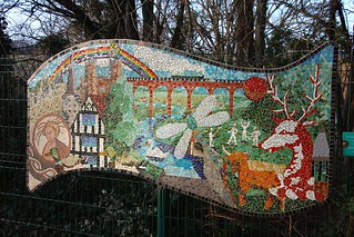
Eynsford Circular via Farningham walk
Ancient woodlands, low hills and riverside paths in the Darent valley.


| Length |
Main Walk: 16¾ km† (10.4 miles). Four hours 5 minutes walking time. For the whole excursion including trains, sights and meals, allow at least 8 hours. Short Walk 1, omitting southern loop: 12½ km† (7.8 miles). Three hours walking time. Short Walk 2, omitting northern loop: 12¼ km (7.6 miles). Two hours 55 minutes walking time. Short Walk 3, also omitting central loop: 9 km (5.5 miles). Two hours 10 minutes walking time. † Add 1¾ km (1.1 miles; 25 minutes) if taking the Horton Kirby extension. See Walk Options below. |
|---|---|
| OS Maps |
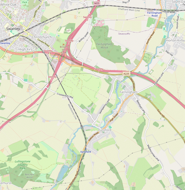
Explorers 162 & 147. Eynsford, map reference TQ535649, is in Kent, 10 km N of Sevenoaks. |
| Toughness |
4 out of 10 (3 for Short Walks 1 & 2, 2 for Short Walk 3). |
| Features |
This walk covers a section of the Darent Valley Path between Lullingstone and Horton Kirby, with stretches alongside the river contrasting with others in the surrounding hills. Its first encounter with the river is by Lullingstone Roman Villa (01322-863467), which has two well-preserved mosaic floors and some early wall paintings dating back to AD 75. The site is managed by English Heritage and is normally open to the public, but has been closed throughout 2024 for essential repair work. The walk continues up the side of the valley and heads south-west before looping back through Lullingstone Country Park, an attractive landscape of chalk grassland and ancient woodland with an internationally important collection of veteran trees. It returns to the river by Lullingstone Castle (01322-862114), a historic manor house which can be visited (but with limited opening hours). Its grounds contain an unusual parish church (freely open to the public at all times) and a World Garden with plants from around the globe, open Thu–Sun from April to October; admission (2024) is £9. The walk goes back across the outward route at the Roman Villa and then skirts Eynsford on its hillside route to the neighbouring village of Farningham. It continues through a riverside beer garden (overlooking a unique and puzzling structure in the river) and passes under the main roads which now take all the through traffic away from the village, which was once on the main London-to-Folkestone highway. At its northernmost point the walk swings round to cross the river, with an optional extension through the village of Horton Kirby. The return leg includes a short stretch through the eastern part of Farningham Woods Nature Reserve before another encounter with Farningham's attractive High Street. Much of the final stretch to Eynsford is along roads but it does include the opportunity to explore the ruins of Eynsford Castle, one of the earliest Norman stone castles (free entry). |
| Walk Options |
As the walk features several crossover points it can easily be shortened by cutting out some of the loops. Three Short Walks are described here. Short Walk 1 cuts out the southern loop via Lullingstone Park, substituting a short link route past one of the UK's largest Bird of Prey centres, Eagle Heights; admission (2024) is £13.95 but you might be able to see something of the midday flying display from the public footpath. The other options include Lullingstone Park but cut out some or all of the northern loops: Short Walk 2 turns back from Farningham, while Short Walk 3 goes no further than Eynsford. As mentioned above, the Main Walk and Short Walk 1 can be extended by 1¾ km with an extra stretch out alongside the river and returning through the village of Horton Kirby. Another option would be to break off from this loop and return from Farningham Road station (see Transport below). |
| Additional Notes |
The author's original intention was to squeeze all these circular walk options into the (renamed) Farningham Road to Otford walk (#291), but on reflection it was decided to split them off into this new walk. The old walk's southern loop (around Lullingstone Park) has been transferred to this walk, and those sections which appear in both walks are mostly done in opposite directions. |
| Transport |
Eynsford is on the Blackfriars to Sevenoaks line, with a half-hourly stopping service taking 55 minutes. You can also take a fast train from Victoria or Charing Cross and change at Bromley South or Swanley for the Sevenoaks train. Buy a return to Eynsford. If you have a Travelcard the Boundary Zone 6 station is St Mary Cray, but a London Freedom Pass is valid as far as Swanley (in TfL Zone 8). At the northernmost part of the walk you could divert to Farningham Road station, which is on a different line with an hourly service to Victoria. You would then need to buy a single to Swanley, where the two lines merge. If you want to abandon the walk in Farningham there is a bus service to Swanley from the stop outside the Lion Hotel (hourly Mon–Fri, two-hourly Sat). There is also a very limited service (Mon–Sat) along the A225 between Sevenoaks and Swanley. If driving, there is a small car park “free for rail users” at Eynsford station. There is also a small free car park in the village (near the return route, but nearly 1 km from the station). |
| Suggested Train |
Take the train nearest to 10:15 from Blackfriars to Eynsford. A later train would be fine for the Short Walks. |
| Train Times |
|
| Timetables |
|
| River Levels |
|
| Lunch |
For most of the walk options the obvious place to stop for a pub lunch (after 9¼ km, but only 5 km on Short Walk 1) is the popular Lion Hotel (01322-860621) in Farningham, since the route goes through its riverside beer garden. If it is too crowded the Pied Bull (01322-862125) is a short distance away along the High Street; both places serve a good selection of food all day. The route also passes The Chequers (01322-865222), but this small and quirky pub might be closed at lunchtime. If you do the northern extension you would have a later option in Horton Kirby, 3 km further on: the Fighting Cocks (01322-862299) is a family-friendly pub / restaurant which also has a large beer garden stretching down to the river. If you are doing a Short Walk and just want to stop near the end there are several pubs in Eynsford. Short Walk 3 passes the Plough Inn (01322-862281) on Riverside, while the other options pass the Castle Hotel (01322-633917) and the Five Bells (01322-863135; open from 3pm weekdays, noon weekends) on the High Street. |
| Tea |
The Riverside Tea Room in Eynsford has permanently closed, so the refreshment places near the end of the walk are the three pubs listed above: the Plough Inn, the Castle Hotel and the Five Bells. The station is around 1 km away from all of them via the main road, but you should allow 20–25 minutes to reach it on the slightly longer and hillier suggested route. |
| Profile | |
|---|---|
| Help Us! |
After the walk, please leave a comment, it really helps. Thanks! You can also upload photos to the SWC Group on Flickr (upload your photos) and videos to Youtube. This walk's tags are: |
| By Train |
Out (not a train station) Back (not a train station) |
| By Car |
Start DA4 0HP Map Directions |
| Amazon | |
| Help |
National Rail: 03457 48 49 50 • Traveline (bus times): 0871 200 22 33 (12p/min) • TFL (London) : 0343 222 1234 |
| Version |
Jun-24 Sean |
| Copyright | © Saturday Walkers Club. All Rights Reserved. No commercial use. No copying. No derivatives. Free with attribution for one time non-commercial use only. www.walkingclub.org.uk/site/license.shtml |


Walk Directions
Click the heading below to show/hide the walk route for the selected option(s).


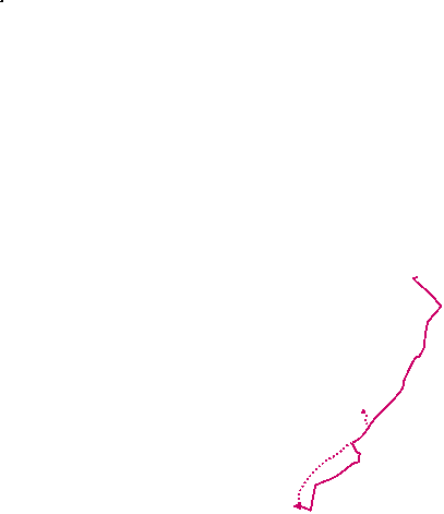

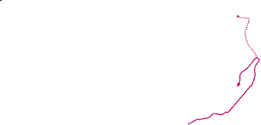


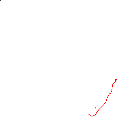
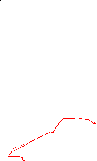

 Walk Map
©
Walk Options
Click on any option to show only the sections making up that route, or the heading above to show all sections.
- Main Walk (16¾ • 18½ km)
The longer distance includes the Horton Kirby extension.
Walk Directions
Click on any section heading to switch between detailed directions and an outline, or the heading above to switch all sections.
- Eynsford Station to Hulberry Hill (1¾ km)
- Go down to the A225 and turn left onto the main road. In 400m turn right onto a farm track and follow this past Newbarn Farm and across the River Darent. Turn left briefly in front of the Roman Villa, then turn right onto a footpath. Follow the Darent Valley Path (DVP) for 500m up the side of the valley to a footpath junction.
- Turn left out of the station and go down to the A225. Cross this busy main road with great care and turn left onto the pavement, going under the railway bridge. You have 400m of walking alongside the A225, until just past the end of a lay-by on the left.
- At this point turn right onto a farm track, signposted as a footpath. Follow this track for 600m, past Newbarn Farm and a cottage. After crossing the River Darent turn left onto a lane in front of a large shed housing Lullingstone Roman Villa.
- Before reaching the first cottage on the lane turn right up steps in the wooded bank, joining the Darent Valley Path? (DVP). At the end of the trees continue up the left-hand side of a large field for 400m, where there is a footpath junction in front of a hedge stretching across the field.
- Hulberry Hill to Castle Drive (1¾ km)
- Keep ahead at the path junction (leaving the DVP), then veer left to follow the waymarked Lullingstone Loop along the edge of Lullingstone Country Park, heading south-west. At the end of a long strip of woodland you reach the old driveway to Lullingstone Castle.
- Keep ahead at the path junction, leaving the DVP. In 75m veer left through the belt of trees at another footpath junction, following a black arrow waymarker for the Lullingstone Loop (LL). You pass an information panel for the Lullingstone Tree Acrostic? at the start of a line of young trees and continue on a broad grassy strip between fields, gently uphill at first.
- On the brow of the hill you pass a bench inviting you to “Rest here a while” by an isolated tree, the Hart Dyke Sycamore?. After descending to the far side keep ahead on a track between hedges, entering Lullingstone Country Park? (with its golf course) and also joining a horse route (blue arrows). Follow these waymarked routes through a dip and up a wooded slope into the corner of a field.
-
After going along the right-hand field edge you enter a 600m-long narrow strip of woodland, with a choice of routes through it. The horse route along its right-hand side gets slightly more road noise from the M25 (in a cutting 1 km away) so the suggested route is to take the left-hand path, staying on the LL.
Both of these routes pass some ancient oak trees. About 100m before the end of this wood the “Golf Course Ancient Oak” on the edge of the fairway is thought to be the oldest in the park.
- Where the two routes rejoin go straight across a golfers' track (slightly to the left from the LL) to continue through another patch of woodland. In 200m the path emerges from the trees onto a surfaced track, the route of an old driveway to Lullingstone Castle.
- Castle Drive to Beechen Wood (exit) (1¼ km)
- Turn left onto the old driveway. In 100m bear right to stay on the horse route as it descends into a valley. In 400m turn right and follow a children's Discovery Trail through Upper and Lower Beechen Woods.
- Turn left to go downhill on this track, leaving the LL but staying on the horse route. In 100m bear right onto a stony track going down through the golf course, initially with a tall hedge on your left. The track gradually approaches Upper Beechen Wood on the right, at the bottom of the valley.
- After going alongside it for a short distance turn right into the wood at a marker post, leaving the horse route. The path passes “Wild Wire” (a zip-wire contraption) on the right and climbs gently. Go past a metal fieldgate on the right and follow the main path down to the left. You are now on a children's Discovery Trail, with red arrow waymarkers.
- At the bottom go straight across a small open valley, passing a bench inscribed with leaf shapes and a “Woodland Rides & Glades” information panel. Go past a metal fieldgate onto a path climbing steadily through Lower Beechen Wood. You pass another bench (insect shapes) and sculptures along the way, as well as several children's activity areas down to the left.
- In 400m the path swings left by a signpost to the Visitor Centre Car Park and starts to go gently downhill. You pass a few more wooden sculptures at the edge of the wood and leave it through a metal kissing gate, emerging onto the top of a stretch of open downland with fine views across the Darent valley.
- Beechen Wood to Lullingstone Castle (1 • 1¼ km)
-
Turn half-left onto a grassy horse ride sloping down the hillside and continue in this direction for 750m to rejoin the old driveway through the park. Turn right onto it and go down to Lullingstone Castle.
- Alternatively, go straight ahead down the chalk grassland to the Visitor Centre (which has a café). Turn left onto the DVP and follow it alongside the river to Lullingstone Castle.
-
Main route (1 km)
- Turn half-left onto a broad grassy path slanting down the hillside, staying on the Discovery Trail and rejoining the horse route (blue arrows). The path gradually approaches the boundary with the golf course, down to the left.
- In 250m you come to the first of several path junctions; go straight ahead at all of them, leaving the waymarked routes. Soon you might be able to glimpse a large fishing lake in the valley off to your right, and the church and buildings of Lullingstone Castle directly ahead.
- In 250m the path briefly merges with the horse route from the right, but shortly afterwards you leave it again where it veers left towards a gap in some trees. There is now a large farm field sloping down to your right, and a line of shrubs and trees on your left.
- The path gradually bends left and in 250m comes to a T-junction with a track (the old driveway you were on earlier), with a large cedar tree directly ahead. Turn right onto the track, which curves downhill alongside the farm field.
- At the bottom go through a gap in the hedge and bear left onto a tarmac lane to reach the imposing entrance to Lullingstone Castle.
-
Route via Visitor Centre (1¼ km)
- Take any route down the grassy slope ahead. At the bottom make your way through the car park to the café in the Visitor Centre.
- To continue the walk skirt around a children's playground to find the River Darent in the belt of trees behind the Visitor Centre. Turn left onto the riverside path, rejoining the DVP.
- Follow this attractive tree-lined path for 600m, with glimpses of a large fishing lake beyond the river on your right.
- At the far end go through a small parking area and keep ahead on …
- Lullingstone Castle to Eynsford (Lullingstone Lane) (1¾ km)
- Go all the way along Lullingstone Lane to a road junction on the outskirts of Eynsford, temporarily leaving the DVP at the Roman Villa where it takes a higher route along the side of the valley.
- Follow the lane past the grounds of Lullingstone Castle (with its World Garden behind a high brick wall at the end). In 700m you briefly go back along a short section of your outward route as you pass the large shed housing Lullingstone Roman Villa.
- Continue along Lullingstone Lane for a further 1 km, with the river meandering away in the valley on your right. You pass a turning on the left for Eagle Heights and later go under Eynsford Viaduct?.
- Eventually the lane curves around a water meadow dotted with trees and comes to a road junction on the outskirts of Eynsford, with Sparepenny Lane on the left and the road ahead continuing as Riverside.
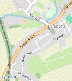
- Lullingstone Lane to Eynsford Station (1½ km)
-
…
Keep ahead on Riverside, which comes out onto the main road opposite the church.
…
- To complete Short Walk 3 keep ahead at the junction. In 150m Riverside justifies its name by going right alongside the river. On this attractive stretch you soon come to the Plough Inn, the suggested tea place.
- Carry on along Riverside, crossing the River Darent on a narrow road bridge by a ford (with refuges to avoid the traffic if necessary). You pass the (closed) Riverside Tea Room and come to a T-junction with the A225, with the church of St Martin of Tours? opposite.
-
Detour to Eynsford Castle (+800m)
- Turn left onto the main road (away from the station) to go through the village. In 250m you pass the Five Bells pub on your right, then the Castle Hotel.
- Turn left …
- …
- …
- Hulberry Hill to Eynsford (Lullingstone Lane) (1½ km)
- Turn right at the path junction, staying on the DVP. Follow the footpath past Eagle Heights, then downhill across the railway line. Turn left onto Lullingstone Lane to come to a junction with Sparepenny Lane.
-
In front of the hedge turn right to go alongside it, staying on the DVP. Where the hedge turns left keep ahead across the field, passing Eagle Heights off to your left.
If your walk coincides with a flying display you might see eagles and other exotic large birds overhead. They are not supposed to attack walkers who stay on the public footpath.
- Go across the centre's access road and through a gap in the fence opposite. Take the footpath sloping downhill across more large fields, heading towards Eynsford in the valley below and crossing the railway tracks near the left-hand end of Eynsford Viaduct?.
- The path eventually drops down to a minor road. Bear left onto Lullingstone Lane, which …
- Lullingstone Lane to Farningham (Lion Hotel) (1¾ km)
-
 At the junction turn left into Sparepenny Lane. In 200m go through a gate on the right to continue on a permissive footpath parallel to the road for 1¼ km, along the top of several large fields and a small wood. At the end return to the road and go downhill to a T-junction. Turn right and go down Farningham's High Street to the Lion Hotel by the River Darent.
- At the junction turn left into Sparepenny Lane? and follow it uphill for 200m, passing Crockenhill Lane on the left halfway along. At the entrance to Furlongs Farm go through a gate with a footpath signpost and down a few steps into the top corner of a large farm field, with the ruins of Eynsford Castle visible in the valley below.
- Follow this permissive footpath for 1¼ km, mostly along the top of large fields but with a short interlude through the top of Nine Hole Wood?. The path never strays far from Sparepenny Lane and towards the end you might be able to glimpse Farningham church in the valley ahead.
-
In the far corner of the last field return to Sparepenny Lane via a gate and a few steps. Turn right and follow the road downhill into the village. At a T-junction turn right to go down Farningham's narrow High Street, passing The Chequers pub at its junction with Dartford Road.
-
Before reaching the bridge over the River Darent veer left onto a path through the beer garden of the Lion Hotel, a possible lunch stop. At the river's edge an information panel describes what is known about the ornate Farningham Cattle Screen? spanning the river here.
If you are doing the northern loop you will have another chance to visit this inn 1–1½ hours later, depending on whether you also take the Horton Kirby extension.
- If you have brought your own provisions there is a designated picnic area on the other side of the river. Cross the road bridge and turn left through a gate into this pleasant grassy enclosure with benches, overlooking the river.
- The Lion Hotel to Franks Lane Bridge (1¾ km)
- Follow the DVP through the inn's garden and alongside the river, crossing over to the other bank where it passes under the A20. The riverside path later goes under the M20 and then moves away from the river. At the end of a long straight stretch turn left onto Franks Lane and follow it for 200m to return to the River Darent, crossing it on Franks Lane Bridge.
- Follow the Darent Valley Path through the inn's garden and continue alongside the river, with a wooded area on your left. In 200m the path crosses the river on a footbridge and goes underneath the A20.
- In a further 250m the riverside path goes under the second main road bypassing the village, the M20. After swinging right and left there is an attractive 150m stretch right by the water's edge before the path turns away from the river, zig-zagging right and left to continue as a long straight path between fences.
- At the far end of this enclosed path you pass Horton Kirby Cricket Club on the right; you might also be able to glimpse Franks Hall? away to the left, through a gap in the trees. Go out through a wooden kissing gate and turn left onto a minor road (Franks Lane).
- Go along this lane for 200m, taking care as there is no pavement and more traffic than you might expect. After it crosses the River Darent on Franks Lane Bridge there is a signposted footpath off to the right, the continuation of the DVP.
- Franks Lane Bridge to Calfstock Lane (½ • 2¼ km)
-
- For the Horton Kirby extension, turn right onto a footpath alongside the river, staying on the DVP. In Westminster Field go past a car park and back across the river on its access road. Turn right onto The Street and follow this lane through Horton Kirby to the Fighting Cocks pub. Where the lane turns left keep ahead on a footpath. Fork right at a path junction to return to Franks Lane and cross the river again.
-
Extension via Horton Kirby (+1¾ km)
- Turn right onto the footpath, which stays close to the water for 300m. After the river curves away the path continues alongside a fence and then through an area of scrubland. At the end go through a wooden kissing gate into the corner of a recreation ground, Westminster Field.
-
Keep right to go alongside a car park towards a sports pavilion. Just beyond its access road there is a grassy riverside enclosure with benches which would be suitable for a picnic.
- If you want to abandon the walk and return from Farningham Road station (just over 1 km away), take the surfaced path heading NW across the recreation ground, along an avenue of young cherry trees. On the far side go past a vehicle barrier and up a gentle slope on a fenced path. At the top bear right in front of the A225 onto a tarmac path and follow it to the junction with Station Road. Cross the A225 carefully and go up the approach road to the station. Platform 1 on the near side is for trains to London.
- To continue the walk cross the river on the access road, leaving the DVP. Go past the side of a new housing development and out onto a lane (The Street) at a bend, by a village sign for Horton Kirby.
- Turn right onto The Street to go through the village. In 250m you come to the Fighting Cocks pub / restaurant on the right-hand side of the road, another possible lunch stop.
- The walk continues along The Street. Where this lane turns sharply left after 150m keep ahead on a footpath along the right-hand edge of a field. In the next corner follow the footpath round to the right, through a gap in the tree boundary.
- Go through a metal kissing gate and fork right (almost straight on) where the path splits. At the end of this fenced path go through another gate and turn right onto a road (Franks Lane again) to repeat a short stretch of your earlier route, crossing the river again.
- Carry on along Franks Lane, soon passing the modern brick entrance to Franks Hall on the left. After climbing gently for a further 200m keep left where the road forks by the entrance to The Lodge to come out onto the A225. Turn left and go along its pavement, heading back towards Farningham. In 175m cross the main road carefully into Calfstock Lane
- Calfstock Lane to the Lion Hotel (2¼ km)
- Go up Calfstock Lane for 450m, then turn left into a field on the eastern edge of Farningham Wood (Purgate Bottom). Follow a fenced track up its right-hand side. At the top turn right onto a broad woodland track which curves left and comes to a viewpoint on the southern edge of the wood. Leave the wood and go along two sides of a large field down to its bottom left-hand corner. Go through a small wooded area and turn right onto the A225, going under the M20. Go straight across the A20 at a roundabout and down through the Lion Hotel's car park to return to its garden.
- Follow this long cul-de-sac uphill, passing a number of houses in the first 200m. After the last property ignore a track on the left (leading up to Great Folly Field) and continue along the lane for a further 250m, now with fields behind hedges on both sides.
- Shortly before reaching a wood veer left towards a fieldgate and go through a side gate with a “Walkers Welcome” sign. Ignore a stile into the field ahead (Purgate Bottom) and follow a fenced grassy track all the way up its right-hand side.
- At the top turn right onto a broad woodland track through the eastern part of Farningham Woods Nature Reserve, which curves round to the left to head SSW for 250m. It comes to a recently-cleared area at the southern edge of the wood (with a view across a large field to Farningham in the Darent valley, and the M20 motorway snaking through the landscape).
- Leave the wood through a wooden kissing gate and turn left, now on a public footpath heading E along the top of the field. In the next corner veer right, staying inside the field on the right of way, and go all the way down its left-hand edge.
- In the bottom corner keep left, going past a vehicle barrier onto a short concrete track. This leads into the turning circle at the end of a cul-de-sac where you take a path on the right into a wooded area, sloping downhill with a few steps along the way. At the bottom turn right again to come out onto the pavement of the A225 (Dartford Road). Follow it under the M20 towards a roundabout.
- You need to reach the minor road directly opposite, the continuation of Dartford Road. You can avoid the slightly awkward area in front of the service station by switching to the left-hand side of the A225 before crossing the other main road, the A20; in both cases use the traffic islands and take great care as traffic can be quite fast.
- After going down Dartford Road for 125m turn left into the Lion Hotel's car park. Make your way down to its beer garden in front of the River Darent, completing the walk's northern loop.
- The Lion Hotel to Eynsford (Castle Hotel) (1¾ km)
-
Cross the river on the road bridge and follow the High Street past the church to the Pied Bull pub. Turn right onto an alleyway (Cinder Path) and continue along Oliver Crescent and Till Avenue to the A225. Turn right onto the main road, towards Eynsford. In 125m you can take a parallel footpath on the right for 250m, but for the rest of the way you have to go along the pavement.
- At the Castle Hotel you could detour off to the right to visit Eynsford Castle.
- Go out onto the High Street and turn left to cross the river on the road bridge, with a fine view of the Cattle Screen as well as the Farningham Mill? development upstream. In 125m you could detour through the churchyard of Ss Peter and Paul? as there is another gate at the far end. In a further 100m you pass another pub, the Pied Bull.
- Go past its car park and turn right into Cinder Path, signposted as a footpath. At the end of this short alleyway keep ahead on Oliver Crescent. After passing a small green bear left in front of a large triangular green onto a signposted footpath. Follow this short tarmac path and then a cul-de-sac (Till Avenue) alongside the green to the A225 and turn right onto its pavement.
-
You have to walk most of the way into Eynsford on this main road, but in 75m you can get some respite from the traffic by veering right through a wooden gate onto a signposted public footpath; this goes along a strip of grassland parallel to the road for 250m, with a hedge on the right.
- You could also detour along grassy paths through the adjoining Millfield Meadow; there are several gaps in the hedge.
-
At the end of the meadow you have to put up with the traffic for 500m, passing a row of cottages, a primary school and the Baptist Church (all on the right-hand side of the road) before you reach the Castle Hotel on your left.
- If you want to visit the ruins of Eynsford Castle (which is only 125m away) turn right into the lane opposite the hotel, signposted to the Village Hall. The lane zig-zags right and left and a broad wooden bridge takes you through a gap in the curtain wall into the site. Return the same way.
- The Castle Hotel to Eynsford Station (1¼ km)
-
 The suggested route is quieter than walking along the A225 to the station.
Continue along Eynsford's High Street to the church.
Go up the left-hand side of the churchyard and then along an alleyway to Pollyhaugh. Turn right and follow this residential street (which becomes St Martins Drive) to a T-junction. Turn right down Eynsford Rise for the station.
The suggested route is quieter than walking along the A225 to the station.
Continue along Eynsford's High Street to the church.
Go up the left-hand side of the churchyard and then along an alleyway to Pollyhaugh. Turn right and follow this residential street (which becomes St Martins Drive) to a T-junction. Turn right down Eynsford Rise for the station.
- To complete the walk continue along the left-hand side of the High Street, soon passing the Five Bells pub and then the War Memorial at a road junction. In a further 200m you come to the church of St Martin of Tours?, opposite a road leading to the river.
-
The suggested route to the station is a quiet route away from the main road. Take a tarmac path up the left-hand side of the churchyard to an exit in its top corner. Bear right across a small parking area and go up a short alleyway (with vehicle barriers at both ends) to a residential street.
-
Turn right and follow this quiet street (Pollyhaugh, later St Martins Drive) for 700m, climbing steadily. At the far end turn right and go down Eynsford Rise to the station. Cross the footbridge to Platform 1 for trains to London.
- The Darent Valley Path follows the course of the river for 31 km, from Sevenoaks (near its source in the Greensand Hills) to the River Thames at Dartford.
- The Lullingstone Tree Acrostic is one of the Queen's Green Canopy projects commemorating Her Majesty's Platinum Jubilee in 2022. The first letters of the 13 tree names spell out SAVE THE PLANET.
- The Hart Dyke Sycamore was planted in 1871 by the owners of Lullingstone Castle to celebrate the birth of their son and heir, Percival Hart Dyke.
- Lullingstone Country Park was a medieval deer park in the estate of Lullingstone Castle. Some of its veteran trees (notably oak, hornbeam, beech and sweet chestnut) are over 500 years old. The park was used as a decoy airfield in World War Ⅱ and as a result Shoreham was dubbed “the most heavily bombed village in Britain”.
- The Tudor Gatehouse of Lullingstone Castle was one of the earliest all-brick buildings in Britain.
- St Botolph, Lullingstone dates from the 14thC and contains some impressive memorials to ancestors of the Hart Dyke family, the owners of Lullingstone Castle. It also has an elaborately carved wooden rood screen and some particularly fine stained glass windows, the oldest dating back to the 14thC.
- Eynsford Viaduct was built in 1862 to take the railway over the Darent valley, with nine high brick arches and a stone parapet. In the past some repairs have been made with poorly-matched bricks and it has been given listed building status to maintain its original appearance.
- St Martin of Tours, Eynsford was built by one of William the Conqueror's knights in the 11thC on the site of a Saxon church. It has retained its Norman ground plan with apsidal chancel.
- The name Sparepenny Lane implies this was a private toll road which was cheaper than the main turnpike.
- Nine Hole Wood was gifted to the Woodland Trust in 1997. This open-access woodland was originally part of a 9-hole golf course.
- The Farningham Cattle Screen was once thought to have been the remains of a medieval bridge, or an 18thC folly. It is not known why such an ornate structure was built simply to prevent cattle from straying downstream while crossing the ford. It was restored by the Parish Council in 2008/9.
- Franks Hall is a large Elizabethan country house, completed in 1591. The estate declined in the 19thC and it had multiple owners in the 20thC, most recently as a business headquarters.
- Farningham Mill was built in the late 18thC. In 2013 the water mill and surrounding properties were converted into a residential estate.
- Ss Peter and Paul, Farningham dates from the 13thC; the tower was added about a century later and enlarged in the 19thC. It contains a painted alabaster monument of 1597 to Antony Roper, the grandson of Sir Thomas More. Unusually for an Anglican church, the 15thC font depicts the Seven Sacraments of the Roman Catholic church.
If you are doing Short Walk 1 (omitting the southern loop via Lullingstone), go to §G.
If you want to break for refreshments take the route in [?].
For all walk options except Short Walk 3 (which omits the central and northern loops via Farningham), go to §H.
Follow the directions below if you want to visit the ruins of Eynsford Castle.
If you are doing Short Walk 2 (omitting the northern loop via Franks Lane Bridge), go to §K.
If you are not visiting the riverside picnic area or pub in Horton Kirby you could skip the loop below.
Walk Notes
» Last updated: October 17, 2024
Return to Top | Walk Map | Walk Options | Walk Directions.