Fairholmes Circular (via Bleaklow and Derwent Head) Walk
From a remote bus stop onto one of England’s few great, untamed wildernesses: Bleaklow. Descend either across moors and Derwent River's Head, or Westend Valley.

Trig Point on Westend Moor, with Bleaklow beyond
SWC Walk 350 - Fairholmes Circular (via Bleaklow and Derwent Head)
Sep-19 • thomasgrabow on Flickr
swcwalks swcwalk350 banner 49017629243

The Path across Bleaklow
SWC Walk 350 - Fairholmes Circular (via Bleaklow and Derwent Head)
Sep-19 • thomasgrabow on Flickr
swcwalks swcwalk350 walkicon 49017627943
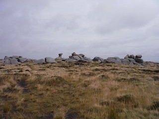
Bleaklow Stones
SWC Walk 350 - Fairholmes Circular (via Bleaklow and Derwent Head)
Sep-19 • thomasgrabow on Flickr
swcwalks swcwalk350 walkicon 49018350992

The Path through the Groughs along the Watershed
SWC Walk 350 - Fairholmes Circular (via Bleaklow and Derwent Head)
Sep-19 • thomasgrabow on Flickr
swcwalks swcwalk350 walkicon 49018146271
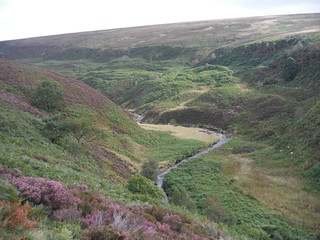
Deer Holes and Lands Side, Upper Derwent Valley
SWC Walk 350 - Fairholmes Circular (via Bleaklow and Derwent Head)
Sep-19 • thomasgrabow on Flickr
swcwalks swcwalk350 walkicon 49018348162
| Length |
27.8 km (17.3 mi), with 674m ascent/descent. For a shorter walk see below Walk Options. |
|---|---|
| Toughness |
8 out of 10 to 10 out of 10, depending on weather and route finding.
|
| Walk Notes |
Quite possibly the wildest and remotest of the fully written up SWC walks, this route leads from a remote bus stop on the famous Derwent Reservoirs through woods onto a grassy boggy ridge past Alport Castles, Britain’s largest inland landslip area with its fascinating rock formations and piles of rocky debris, to one of England’s few great, untamed wildernesses: Bleaklow. Bleak by name, bleak by nature, it is famed for its extensive, wild moorland and is home to two of the three highest points in the Peak District. Despite its reputation as an endless, featureless mass of peat bogs, Bleaklow is quite magnificent though. Its contours are more rounded than Kinder's, but it is less accessible and more remote with fewer paths and features aiding navigation, basically an often-pathless wilderness – rough, boggy, quiet, wild and lonely. But it also has some picturesque gritstone rock formations, worn into shapes by wind and water and plenty of scenic river valleys running off it.
Note: The stretch along the large – and partly pathless – peatland plateau requires excellent navigational skills and very good stamina, as any divergence from the best line requires much higher levels of energy, due to the deep peaty groughs, some watery holes and boggy ground either side of (and sometimes on) the best route. |
| Walk Options |
An Alternative Descent Route from Bleaklow Stones avoids most of the often-pathless crossing of the high moors and leads via Grinah Stones, Barrow Stones, Round Hill, Ridgewalk Moor & the Westend Valley to the road by Howden Reservoir and thence to Fairholmes. This is rated 7/10, with 25.3 km/15.8 mi distance and 609m ascent. |
| Maps |
OS Explorer: OL1 (The Peak District – Dark Peak Area)
|
| Travel |
Derwent, opposite Fairholmes Bus Stop, map reference SK 171 893, is 19 km west north west of Sheffield City Centre, 237 km north west of Charing Cross, 214m above sea level, and in Derbyshire. It is served by bus line 257 from Sheffield Interchange to Bamford Station (journey time 37 mins), but only on Sundays during BST. On the current schedule, the 7 hours 20 minutes left for walking between the arrival of the first bus and the departure of the last will be enough time to finish the shorter Westend Valley Variation, but will not be enough to finish the full walk across Bleaklow (for almost all walkers). A taxi will need to be arranged for one of the journeys for the full walk. Saturday Walkers’ Club: This walk is not doable as a public transport-based day walk from London, due to the infrequent bus service, but if staying in Sheffield or along the Bus Line 257 from there to Bamford, i.e. in the Hope Valley or at the Ladybower or Yorkshire Bridge Inns. |
| Lunch |
Picnic. |
| Tea |
Derwent Café Fairholmes Visitor Centre, Bamford, Hope Valley, Derbyshire, S33 0AQ (01433 650 953). The café is a hot and cold food kiosk with a separate entrance to the VC. |
| Profile | |
|---|---|
| Help Us! |
After the walk, please leave a comment, it really helps. Thanks! You can also upload photos to the SWC Group on Flickr (upload your photos) and videos to Youtube. This walk's tags are: |
| By Car |
Start Map Directions |
| Amazon | |
| Help |
National Rail: 03457 48 49 50 • Traveline (bus times): 0871 200 22 33 (12p/min) • TFL (London) : 0343 222 1234 |
| Version |
Apr-25 Thomas G |
| Copyright | © Saturday Walkers Club. All Rights Reserved. No commercial use. No copying. No derivatives. Free with attribution for one time non-commercial use only. www.walkingclub.org.uk/site/license.shtml |

Walk Directions
Full directions for this walk are in a PDF file (link above) which you can print, or download on to a Kindle, tablet, or smartphone.
This is just the introduction. This walk's detailed directions are in a PDF available from wwww.walkingclub.org.uk