Faversham Circular walk
Around the windswept marshes and waterways of north Kent, with traces of the time when the area was the centre of Britain's explosives industry.
Faversham Circ 21.4.24 IMG_0457 LR
21-Apr-24 • Steven F Coles on Flickr
swcwalks swcwalk420 53671532816
Faversham Circ 21.4.24 IMG_0476 LR
21-Apr-24 • Steven F Coles on Flickr
swcwalks swcwalk420 53671985685
Faversham Circ 21.4.24 IMG_0518 LR
21-Apr-24 • Steven F Coles on Flickr
swcwalks swcwalk420 53671987850

Faversham Circ 21.4.24 IMG_0538 LR
21-Apr-24 • Steven F Coles on Flickr
swcwalks swcwalk420 53671991080
Faversham Circ 21.4.24 IMG_0559 LR
21-Apr-24 • Steven F Coles on Flickr
swcwalks swcwalk420 53670662522
Faversham Circ 21.4.24 IMG_0567 LR
21-Apr-24 • Steven F Coles on Flickr
swcwalks swcwalk420 53671758343

Faversham Circ 21.4.24 IMG_0585 LR
21-Apr-24 • Steven F Coles on Flickr
swcwalks swcwalk420 53671898059
| Length |
Main Walk: 19½ km†‡ (12.1 miles). Four hours 15 minutes walking time. For the whole excursion including trains, sights and meals, allow at least 9½ hours. Short Walk, omitting Oare Marshes: 14½ km† (9.0 miles). Three hours 10 minutes walking time.
† Subtract 1½ km (1 mile; 20 minutes) with morning short cut. See Walk Options below.
|
|---|---|
| OS Map |
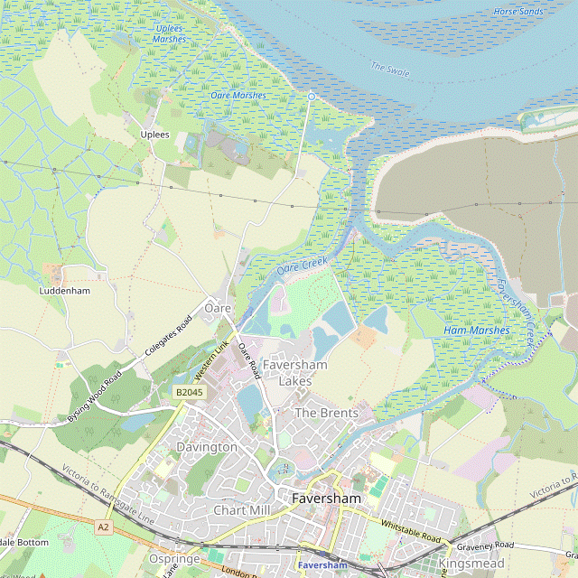
Explorer 149. Faversham, map reference TR016610, is in Kent, 15 km WNW of Canterbury. |
| Toughness |
2 out of 10. |
| Features |
This walk combines and extends two published walks promoted by Faversham Town Council, The Two Creeks Walk and A Walk on the Wild Side (with the latter done in the opposite direction). The initial leg to Oare is a loop around Ham Marshes, an isolated area hemmed in by Faversham Creek and Oare Creek. After a lunch stop in Hollowshore or Oare the walk deviates from the publications by detouring through Oare Gunpowder Works Country Park, where the remains of its massive structures are scattered around a patch of woodland outside the village. Its Visitor Centre (open 10–4 on Sat, Sun & BH from mid-March to mid-November) tells the story of gunpowder manufacture at Oare and details the range of wildlife habitats on the site. A quiet country lane leads you to the hamlet of Luddenham, with its impressively large medieval church of St Mary now seemingly marooned in a farmyard. The full walk continues through farmland and past Uplees Marshes to the Swale, the tidal channel between the mainland and the Isle of Sheppey. It loops around Oare Marshes Nature Reserve and goes back through Oare and Faversham's town centre to the station. Faversham is an attractive market town with many historic buildings, especially in its pedestrianised centre and farther out along Abbey Street (use this History Trail if you want to explore it further). The town was an important sea port before Faversham Creek silted up and in the 11thC it joined the Confederation of Cinque Ports as a ‘limb’ of Dover. In the 16thC it became a major producer of gunpowder and there are still traces of the many factories established in the town itself and the surrounding areas. At one time Faversham could claim to be the centre of Britain's explosives industry but the last three factories closed in 1934, with all production being transferred to Scotland because of the threat of World War Ⅱ. There are plenty of opportunities for bird-watching on both the morning and afternoon legs. Faversham Creek and the Swale support a wide range of resident waterfowl such as avocet, redshank and oystercatchers, with flocks of dunlin and brent geese in winter. |
| Walk Options |
The Short Walk omits the long afternoon loop out to Oare Marshes by taking a direct route back to Oare. This link route is also described in the opposite direction to provide an afternoon short cut on the Main Walk, bypassing the Gunpowder Works (as with “A Walk on the Wild Side”). On both walk options you could replace the long stretch alongside Faversham Creek with a more direct route across Ham Marshes. This morning short cut would be worth considering if you missed a train and wanted to catch up with the main group at Hollowshore or Oare. |
| Additional Notes |
The Teynham to Faversham walk (#299) is a longer SWC walk in this area, taking in the extensive orchards around Teynham as well as a much longer stretch along the coast path, from Conyer to Oare. Its three alternative endings into Faversham are essentially the same as the routes described here (two out and one back). |
| Transport |
Faversham is on the Kent Coast line, with a half-hourly service from Victoria to Ramsgate or Dover taking 70-75 minutes, plus an hourly High Speed service (at a slightly higher fare) from St Pancras taking 65-70 minutes. If you travel out from Victoria you can buy a “Plus High Speed” supplement at Faversham if you decide to travel back on this route. Weekend services are often affected by engineering works, with the Victoria trains sometimes running from Charing Cross or Cannon Street. Once out of Faversham there are no useful bus routes if you want to curtail the walk, apart from a ‘Faversham Hopper’ community bus running between Oare and Faversham on Wednesdays. |
| Suggested Train |
Take the train nearest to 10:00 from Victoria or St Pancras to Faversham. A later train would be possible for the Short Walk. |
| Train Times |
|
| Timetables |
|
| Lunch |
Outside Faversham the first pub encountered (after 5¼ km on the main route) is the Shipwright's Arms (01795-590088; closed Mon & Tue and possibly other days in poor weather) in Hollowshore, a remote spot at the confluence of the two creeks. This old-fashioned pub does not take bookings and caters mainly to birders and walkers on the coast path, with a limited menu: burgers, jacket potatoes, sandwiches, etc. Twenty minutes further on there are two pubs and a café in the small village of Oare. The Castle (01795-533674; closed Mon) is a traditional pub where it would be advisable to call ahead on weekends. The Three Mariners (01795-533633) is an up-market pub / restaurant which closed briefly in 2024 but reopened in June with new tenants; you would need to check that it has started serving food again. Lighter fare is available at The Cafe by the Creek (01795-537985). Note that all of these lunch places might be closed on Mondays (except Bank Holidays). |
| Tea |
The three places in Oare might function as a mid-afternoon refreshment break since you go back through the village at the end of the outer loops, 1½–2½ hours later; the pubs should be open for drinks but the café closes at 4pm summer, 3pm winter. There are many possible refreshment places at the end of the walk, in Faversham. Three places near the central Market Place are The Refinery at 122 West Street (a coffee shop and bar, open to 4pm Sun–Thu, 9pm Fri & Sat) and two places facing the Guildhall on Court Street: Café Guild at #48 (01795-590077; open daily to 5pm) and Havishams Caffè at #47 (01795-591571; open to 5.30pm Mon–Sat, 4pm Sun). There are more cafés and fast-food places along Preston Street, on the route to the station. And with the prominent Shepherd Neame Brewery in its centre Faversham is not short of places supplying stronger fare, such as The Leading Light (01795-535075) near the end of the pedestrianised section, a JD Wetherspoon's pub. The nearest place to the station is the Railway Hotel (01795-501550). You could check out all the various places on the outward route as this also goes along Preston Street and Market Place. |
| Profile | |
|---|---|
| Help Us! |
After the walk, please leave a comment, it really helps. Thanks! You can also upload photos to the SWC Group on Flickr (upload your photos) and videos to Youtube. This walk's tags are: |
| By Train |
Out (not a train station) Back (not a train station) |
| By Car |
Start ME13 8EB Map Directions |
| Amazon | |
| Help |
National Rail: 03457 48 49 50 • Traveline (bus times): 0871 200 22 33 (12p/min) • TFL (London) : 0343 222 1234 |
| Version |
Jul-24 sean |
| Copyright | © Saturday Walkers Club. All Rights Reserved. No commercial use. No copying. No derivatives. Free with attribution for one time non-commercial use only. www.walkingclub.org.uk/site/license.shtml |


Walk Directions
Click the heading below to show/hide the walk route for the selected option(s).


 Walk Map
©
Walk Options
Click on any option to show only the sections making up that route, or the heading above to show all sections.
- Main Walk (19½ km)
Walk Directions
Click on any section heading to switch between detailed directions and an outline, or the heading above to switch all sections.
- Faversham Station to The Brents (1¾ km)
- Head north through Faversham on Preston Street to the Market Place, then skirt around the Shepherd Neame Brewery via Court Street, Quay Lane and Bridge Road, joining the England Coast Path (ECP) and the Saxon Shore Way (SSW). Cross Faversham Creek and follow the ECP / SSW along Front Brents and around a new housing development to a footpath junction on the edge of Ham Marshes.
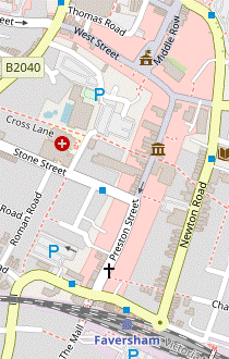
- From the platform go down steps to the subway and turn right to exit the station on its north side. Turn left briefly onto Station Road, then in 50m turn right by the Railway Hotel into Preston Street. Where traffic swings left after 175m into Stone Street, keep ahead through a pedestrianised zone.
- At the far end turn left into Market Street to come to Faversham's impressive Guildhall?, supported on wooden pillars. Turn right in front of the building to go through Market Place?, soon passing Café Guild and Havishams Caffè on the right. Continue along the broad Court Street, passing the Visitor Centre for the large Shepherd Neame Brewery? on the left where the pedestrian precint leads into the B2040.
- In a further 100m the parish church of St Mary of Charity? is visible off to the right at the end of Church Street (both this and Abbey Street ahead are worth a short detour), but to stay on the walk route turn left with the B2040 into Quay Lane; at this point you join both the England Coast Path? (ECP) and the Saxon Shore Way? (SSW). The B2040 swings left again and becomes Conduit Street, passing the timber-framed TS Hazard? building on the right.
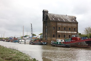
- Before reaching the main brewery buildings turn right into Bridge Road and cross Faversham Creek on the swing bridge. Immediately afterwards turn right into a lane (Front Brents), passing an information panel describing Faversham as The King's Port?. Go all the way along this lane (or the path on the narrow grassy strip beside the creek), passing the Albion Taverna after 150m.
- At the far end keep ahead across a footbridge onto Crab Island, soon passing another information panel depicting The Two Creeks Circular Walk. Follow the path as it zig-zags left and right in front of a wall, now with a green on the left.
- The right of way continues between more high walls and does another left and right zig-zag, but locals cut off this corner by slanting left up the green and going along the lane at the top (Upper Brents). If you do this, bear left off the lane after 25m to rejoin the signposted ECP / SSW.
- Keep right where this paved alleway emerges rather unexpectedly into the corner of a large farm field. In 50m fork right at a footpath Y-junction to stay alongside the boundary wall of a new housing development. Turn right as indicated at the next corner and go up to a metal fieldgate in the field boundary, with a metal kissing gate to its right.
- The Brents to Hollowshore (3½ • 2 km)
-
For a straightforward route stay on the ECP / SSW. Go up to Faversham Creek, turn left onto the embankment and follow it all the way to Hollowshore.
- Alternatively, turn left onto a waymarked footpath heading roughly north past Ham Farm and across Ham Marshes. Turn left onto the ECP / SSW for the final 350m.
-
Route on the Coast Path (3½ km)
- Go through the kissing gate and keep ahead to return to Faversham Creek, 100m ahead. Turn left onto the low embankment, heading NE with marshy pastures on your left and boats and waterfront buildings across the creek, including the prominent Oyster Bay House.
- Continue along the embankment for 3 km, going through metal gates as necessary. The path gradually curves round to the left, occasionally straying away from the creek. At the penultimate gate on this stretch the alternative route joins from a path climbing up the embankment.
-
Route via Ham Marshes (2 km)
- Turn left in front of the gates to go along the field edge for 250m, with a low hedge on your right. Just after the path has curved slightly right, veer left as indicated by a 🡨FOOTPATH signpost in the hedge. Follow a long straight path heading NNE across the field, aiming for a metal fieldgate to the right of some farm buildings 300m away.
- Go through a metal kissing gate beside the fieldgate and keep ahead across two small enclosures at Ham Farm, with a fieldgate in between. On the far side go through another kissing gate beside a fieldgate and bear left as indicated, now heading N and aiming just to the right of a few trees.
- In 250m go through a gap in an earth bank, through a kissing gate and across a water channel on a wooden footbridge. Carry on in much the same direction for a further 250m, towards another footbridge flanked by metal gates. Cross the bridge and turn half-left as indicated to head NW across another field.
- On the far side of this last field cross a reed-lined water channel on another footbridge and follow the path up the low embankment in front of Faversham Creek. At the top turn left onto the ECP / SSW, rejoining the alternative route.
- The path curves right and a straight 350m stretch heading NW alongside the creek brings you to the tiny hamlet of Hollowshore. Go through one more gate and past the beer garden of a possible early refreshment stop, the Shipwright's Arms. After the path turns sharply left in front of a boatyard its entrance is on your left.
- Hollowshore to Oare (1½ km)
- Head south-west alongside Oare Creek on the ECP / SSW, at first on an embankment and then a lane. After passing The Cafe by the Creek turn right and cross the creek into the village of Oare, with its two pubs.
- From the pub return to the ECP / SSW and turn left onto the path, heading SW. Keep ahead at a footpath Y-junction, ignoring another right of way through the pub's car park and passing boats moored on Oare Creek on your right.
- In 300m keep ahead across a lane to continue on the enclosed footpath for a further 450m, with a string of riverside huts on your right and the new Faversham Lakes Country Park beyond the hedge on your left. At the end bear right onto a tarmac lane, away from the entrance to a recycling centre.
- Go all the way along the lane, soon with the old intertidal oysterbeds on your left. At the end you pass The Cafe by the Creek on your right, the first of three possible refreshment stops in the village of Oare. For the other places turn right onto The Street, crossing the creek on the road bridge. The pubs are both nearby on the right-hand side, The Castle and then The Three Mariners.
- Oare to the Gunpowder Works (Visitor Centre) (1½ km)
-
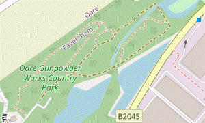 From either of the two pubs go via Oare Meadow Nature Reserve and a byway to the B2045 (Western Link). Turn right to come to a ‘back door’ into the south-eastern corner of the Gunpowder Works (or simply walk along the B2045 to this entrance). Take any route through the Country Park to the Visitor Centre on the far side.
-
The suggested route includes a short loop through the woodland above the industrial ruins, which you could omit (or extend) as you wish.
-
The suggested route includes a short loop through the woodland above the industrial ruins, which you could omit (or extend) as you wish.
-
From The Three Mariners
- From the road junction in front of the pub take the short cul-de-sac opposite Church Road (Mount Pleasant, signposted as a footpath). At the end bear left through a wooden kissing gate onto a grassy path along the top of Oare Meadow Nature Reserve. Ignore gates into the recreation ground on your right.
- At the far end follow the path down the slope. Go through a wooden gate onto a path alongside a garden fence and keep ahead past a group of cottages. Go out along their driveway (which is a restricted byway) and turn right onto the B2045 (Western Link).
-
From The Castle
- Go through the wooden kissing gate across The Street from the pub's parking area into Oare Meadow Nature Reserve. Follow a faint grassy path up a slope towards a wooden fieldgate at the top. Do not go through it into a recreation ground but bear left to go along the top of the slope.
- …
-
From the café
- At the road junction go straight ahead onto the B2045 (Western Link), using the pavement on its right-hand side. In 200m you go past a driveway signposted as a restricted byway, joining the other two routes.
-
In 75m veer right off the pavement onto a track, a ‘back door’ into the south-eastern corner of Oare Gunpowder Works Country Park. Go through a gap in the wooden barrier up to a large information panel in front of the Lower Millpond, displaying a map of the site with some suggested routes through it.
- Go onto the main track through the site, where it runs alongside the millpond (you will probably have to make your way around a small stream flowing into it). Opposite the steps to the wooden viewing platform there is another set leading onto a boardwalk.
- Take this Marshland Boardwalk through the middle of the site, which becomes a normal earth path where it reaches drier ground. The meandering path eventually goes up steps on the left to join the main track, with the Upper Millpond (now a fishing lake) ahead.
- Turn right briefly onto the track, then in 50m turn right again by a Press Houses information panel. Follow a broad path alongside one of the site's canals to an information panel about these Leats.
-
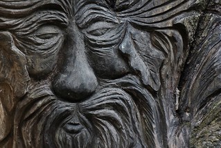
Turn left at this T-junction onto the other arm of the main track through the site, soon passing the Glazing House on the right by a major path junction (with a large wooden sculpture).
- The route now takes a short loop through the woodland above the site and returns to this point. If you want to take a short cut (saving 500m), skip to [?].
- For the full route turn right up a flight of steps alongside the Glazing House and go straight over a crosspaths at the top. Near the far side of the site turn right at a path T-junction. In 150m this woodland path curves right and merges with another path from the right. At the top of some steps there is a viewing point on the right overlooking the Corning House.
- Go down the right-hand flight of steps. Follow the path past the front of the Corning House and alongside one of the canals back to the main track. Turn right onto it, soon passing the Leats information panel again and repeating a short stretch of your earlier route.
- Stay on the main track after the Glazing House, soon passing an information panel for Nos. 1 & 2 Incorporating Mills on your right. You now pass a few buildings on your left, the last of which (with the curved roof) is the Country Park's Visitor Centre.
-
The entrance to the Visitor Centre is on the side facing the small car park, so veer left past another large information panel to go around that side of the building.
-
The slightly convoluted route through the Gunpowder Works has taken you past the main sights, but if you want to explore it further the waymarked routes shown on the information panel are easy to follow.
-
The slightly convoluted route through the Gunpowder Works has taken you past the main sights, but if you want to explore it further the waymarked routes shown on the information panel are easy to follow.
- The Visitor Centre to Luddenham (2 km)
- Go up steps on the right of the driveway to leave via a ‘back door’ in the north-western corner of the site. Turn right onto Tin Shop Hill and go straight over a crossroads. Fork left at the next junction and follow this lane for 900m. Turn right onto a footpath heading north along a field edge into Luddenham.
- From the Visitor Centre return to the main track and turn left. In 40m turn right up a flight of steps leading to the woodland above the site. At the top of a second flight fork left at a Y-junction to come to the end of a long grassy strip, with a Test Range and Laboratory information panel.
- Keep going round to the left to find a short grassy track leading to another ‘back door’ into the site. Go out past a vehicle barrier and turn right onto a quiet country lane (Tin Shop Hill), shown on the OS map as Cycle Route 1 (CR 1).
- The lane climbs gently and soon there are views from this low hill across farm fields and marshland to the Isle of Sheppey, 3½ km ahead. Go straight over a crossroads, with a decorated signpost for CR 1. In a further 150m turn left at the next road junction, ignoring the signpost to Luddenham church and staying on CR 1.
- Follow this quiet country lane, curving right and then left. In 500m ignore a private farm road to Luddenham on the right, and shortly afterwards keep right at a road junction where you pass an attractive house and garden, The Old Rectory. In a further 300m turn right onto a signposted footpath, leaving CR 1 and going through a metal kissing gate into the corner of a large farm field.
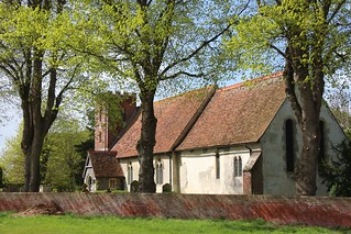
- Keep ahead along the left-hand field edge. In the bottom corner go through another kissing gate onto a grassy path crossing some low-lying ground on a slightly raised embankment. Follow the path up past more gates and farm buildings into the hamlet of Luddenham and fork left onto a track leading to the impressive St Mary's church? (although it is only open at weekends).
- Luddenham to Oare (Creek) (1¾ km)
- Take the footpath heading east across farm fields to Cherry Tree Drive. Cross the lane and continue on a farm track for 200m, then fork right onto a footpath going across the shoulder of a low hill to Uplees Road. Turn right and continue through the village of Oare on The Street, crossing Oare Creek at the far end.
- For the Short Walk turn half-left out of the churchyard and head E across a patch of grass towards a footpath signpost, to the left of a farm building. Go through a metal kissing gate and keep ahead across two farm fields for 400m, passing a large barn off to the left at the end of the second field.
- Go through another kissing gate and straight across a lane (Cherry Tree Drive) onto the continuation of the right of way, a farm track. In 200m, where the track bends left, fork right onto a clear path going over the shoulder of a low hill. The footpath eventually comes out onto a lane (Uplees Road).
- Turn right onto the lane and keep left at a road junction to continue along The Street. Go all the way through the village of Oare, eventually retracing a short part of your outward route where you pass The Three Mariners and The Castle. At the end of The Street you cross Oare Creek; if it is still open, The Cafe by the Creek is a possible refreshment stop.
- Oare to Luddenham direct (1½ km)
- Go through the village on The Street. At the top fork right onto Uplees Road and take a footpath on the left heading west across fields. Keep left at a path junction, cross a lane at Cherry Tree Drive and follow the footpath into Luddenham.
- Go through the village on The Street, ignoring Church Road on the right by The Three Mariners. Where the road turns left in front of open countryside keep right to continue briefly along Uplees Road. In 50m bear left onto a signposted footpath across a large field, a clear path going over the shoulder of a low hill.
-
In 600m the path merges with a track coming in from the right which you follow out to a lane (Cherry Tree Drive). Cross the lane onto the continuation of the footpath, going through a metal kissing gate and passing a barn off to the right. Keep ahead across farm fields for 400m to reach the hamlet of Luddenham.
- Before continuing the walk (along the lane to the right) you might like to detour ahead for a closer look at …
- Luddenham to Dan's Dock (2¾ km)
- Head north on the lane through the hamlet. Where it bends right, take a footpath on the left heading north-east across fields. Bear left onto a byway going past Poplar Hall and continue on a footpath heading north-east to Uplees. Go straight across a lane onto a byway leading to Gate House Bungalows, then on an old tramway past Uplees Marshes to the Swale.
- For the Main Walk turn left out of the churchyard onto a track. Bear left onto the lane leading out of the hamlet, passing several farm buildings on the left. Shortly after it has curved to the right in front of a metal fieldgate, turn left through a metal kissing gate onto a signposted footpath.
- Follow a grassy path heading NNE across three fields, going through another gate and across a footbridge along the way. Go out through a metal kissing gate and turn left onto a farm track.
- Follow this public byway past the right-hand side of a farmhouse (Poplar Hall) on a grassy strip. Go through a kissing gate to the left of a metal fieldgate and along the right-hand edge of a field. In the corner go through a gap into a larger field.
- Follow a grassy path heading NE for 400m, passing under power lines and crossing a wooden footbridge halfway along. On the far side of the field go through a metal kissing gate and straight across a farm track onto a narrow and potentially muddy path between hedges, gently uphill.
- At the top go through another gate to continue on a broad grassy path on the right-hand edge of a field dotted with fruit trees. Leave the field through another gate and go straight across a lane (Uplees Road again) onto the driveway to the right of Uplees Lodge, signposted as a byway.
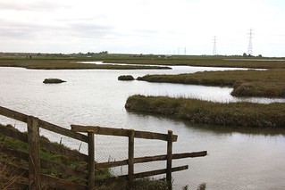
- After passing the last of a string of properties (Gate House Bungalows) go through a metal side gate and keep ahead on a long straight grassy track through Uplees Marshes?, with the remnants of old industrial buildings on both sides.
- At the far end go through a gate and up a short slope onto the sea wall, now with a clear view of the Isle of Sheppey across the Swale. You can see that the coast path has jinked inland to skirt around the disused Dan's Dock, the jetty which served the industrial works on the marshes.
- Dan's Dock to Oare (4 km)
- Turn right onto the sea wall, entering Oare Marshes Nature Reserve and rejoining (in the opposite direction) the ECP / SSW. Follow the embankment past Harty Ferry, round to the right where the two creeks flow into the Swale and then alongside Oare Creek to the village. Unless you want to (re)visit either of Oare's two pubs, turn left to cross Oare Creek on the road bridge.
- Turn right onto the sea wall, going through a metal kissing gate with an information panel for Oare Marshes? (and rejoining the ECP / SSW in the opposite direction). In 900m you go through a pair of gates at Harty Ferry?, passing the car park for the nature reserve down to your right.
- In 600m the path swings round to the right by a bird hide, where Faversham Creek flows into the Swale. The path is now on a slightly lower (and potentially muddier) embankment, heading S or SW for the rest of this section. Nagden Marshes are on the far side of the creek for the next 1 km, in the course of which you leave the nature reserve through a gate.
- At the confluence of the two creeks you might recognise the boatyard next to the Shipwright's Arms at Hollowshore. The path now goes alongside Oare Creek, parallel with your outward route on the opposite bank. After another 1 km the path swerves left and right and goes alongside a string of pontoon berths for 200m.
- At the end of this straight stretch go through a metal gate on the right and follow the path through a small thicket. Keep ahead across a meadow and go out through a wooden kissing gate to return to The Street in Oare. Unless you want to (re)visit either of its two pubs, turn left onto the road and …
- Oare to Faversham Station (2½ km)
-
 At the junction with Western Link keep ahead on Oare Road, leaving the ECP / SSW. In 400m take a parallel cycleway alongside the Faversham Lakes development on the left. Return to the road (now Priory Row) and continue past Davington church and down Davington Hill. At the bottom turn left onto Curtis Way, passing Stonebridge Pond. Bear left onto West Street and follow it across the B2040 to Faversham's Market Place. Retrace your outward route along Preston Street to the station.
- With the village of Oare behind you, go straight ahead onto Oare Road at the junction with Western Link, leaving the ECP / SSW and going through an industrial area. In 250m you pass the sailless Oare Mill? off to the left.
- You could stay on the pavement all the way into Davington, but at the traffic lights ahead the suggested route is to take a parallel cycleway to the left of the road, which runs alongside a high wall surrounding the Faversham Lakes development for 300m. At the end of the cycleway return to the main road (now Priory Row) and follow it past Davington Primary School.
-
In 250m keep left at the junction with Priory Road, passing the parish church of St Mary Magdalene and St Lawrence? off to the right. Follow the road (now Davington Hill) down to the right, passing Stonebridge Pond Allotments? on the left and then the picturesque millpond itself.
- At the bottom turn left onto Curtis Way. In 125m fork left at a Y-junction in front of The Bull Inn to continue along the narrow West Street, lined with historic buildings. At the far end go straight across North Lane / South Road into its pedestrianised continuation.
- In 100m you pass The Sun Inn on the right, then The Refinery coffee shop on the left just before the Market Place and Guildhall; you might remember Café Guild and Havishams Caffè from your outward route, just off to the left.
-
You pass more cafés, fast-food places and pubs as you retrace your steps back to the station: ahead briefly on Market Street before turning right into Preston Street, with the station entrance off to the left at the far end. Trains to London leave from Platforms 1 or 2.
- Faversham Guildhall was built in 1574, although the upper hall had to be rebuilt after a fire in 1814. It was originally a market hall but was taken over by the borough council in 1605 and used for council meetings until 1942. The building is listed Grade Ⅱ*.
- The Market Place is the site of Kent's oldest street market, selling local produce on Tuesdays, Fridays and Saturdays.
- Shepherd Neame Brewery claims to be the oldest brewery in Britain, dating from at least 1698. The town's other large brewery (Fremlin's, then Whitbread) closed in 1990 and is now a Tesco's superstore.
- St Mary of Charity, Faversham is all that remains of Faversham Abbey, which was founded in 1148 by King Stephen and Queen Matilda (who were reputedly buried here). The distinctive ‘flying spire’ was added in the 18thC and the interior was restored by George Gilbert Scott in 1874. It is listed Grade Ⅰ.
- When complete the England Coast Path will run for around 4,300 km, an unbroken path along England's entire coastline. It was officially renamed the “King Charles Ⅲ England Coast Path” in May 2023.
- The Saxon Shore Way runs for over 250 km, from Hastings in East Sussex round to Gravesend on the north Kent coast. It marks a line of fortifications built by the Romans in the 3rdC as a defence against Saxon invaders, on what was the coastline in those times.
- The TS Hazard building was originally a creekside warehouse, built in 1475. It is now used by sea cadets as a Training Ship.
- The King's Port designation comes from the town's history as a Cinque Port; its motto Regis ut arma rego libera portus ego means “Since I provide arms for him free of charge, I am the King's Port”. The town's coat of arms is almost identical to the three lions on the Royal Arms of England.
- St Mary, Luddenham dates from the 12thC and has retained its Norman west door, with zig-zag decoration. The rather incongruous brick tower was added in the early 19thC. The building was declared redundant in 1972 and is now maintained by the Churches Conservation Trust. It is listed Grade Ⅰ.
- Uplees Marshes was once a large industrial site, with a factory manufacturing gun cotton (built in 1873) and another making bombs and shells (1913). The industry was served by the jetty at Dan's Dock, a tramway along the line of the byway leading to it and a light railway to Davington via Oare. In 1916 a huge explosion killed over 100 workers, Britain's worst disaster in this industry.
- Oare Marshes is a Local Nature Reserve owned and managed by Kent Wildlife Trust. It consists of 81 hectares of grazing marsh and freshwater dykes, separated from the saltmarsh of the Swale by a sea wall.
- The Harty Ferry was one of four services between the mainland and the Isle of Sheppey. They lost traffic after the first Kingsferry Bridge was built in 1860; this ferry was the last to close, at the start of World War Ⅰ. The area opposite is called the Isle of Harty as it was once separated from the rest of Sheppey by a water channel.
- Oare Mill was built in the late 18thC or early 19thC. It was a five-storey tower mill which was working as a corn mill until 1919. It was converted into a house in 1963, with a new polygonal roof replacing the original cap. It is listed Grade Ⅱ.
- St Mary Magdalene and St Lawrence, Davington was built in the 12thC as the priory church for a Benedictine nunnery. After the Dissolution the nave was used as the parish church. The interior was restored in 1845 by Thomas Willement, an important figure in the Gothic Revival who had purchased the remains of Davington Priory (now the home of Bob Geldof). The church is the oldest building in the Faversham area and is listed Grade Ⅰ.
- Stonebridge Pond Allotments are on the site of four small gunpowder works, known as the Home Works. Faversham Creek was dammed to create the millpond, originally for a flour mill before becoming the reservoir for the gunpowder industry's water mills.
There is a choice of routes for this section. If the ground looks waterlogged it would be advisable to stay on the ECP / SSW as this is on a raised embankment alongside Faversham Creek, but if conditions permit you could take the more direct route across farm fields and Ham Marshes in [?].
There are several possible continuations. All routes now leave the ECP / SSW, which continues along a footpath off to the right just before The Castle; this is the return route from Oare Marshes on the Main Walk.
If you are taking the afternoon short cut on the Main Walk (bypassing the Gunpowder Works), go to §G; if you are doing the Two Creeks Walk, go to §J.
The most direct continuation is along the B2045 from the café, but to avoid retracing your steps alternative directions with less road walking are given from both of the pubs.
If you are doing the Main Walk, go to §H.
Complete the directions at §J.
Walk Notes
» Last updated: July 12, 2024
Return to Top | Walk Map | Walk Options | Walk Directions.