Fforest Fawr traverse : Craig Y Nos to Llwyn Y Celyn Walk
Remote mountain traverse: limestone scenery, Fan Gyhirych, a glacial escarpment, great views all around. Bus travel.

Walker on Dismantled Tramway through Gash in Limestone Wall
SWC Walk 307 - Fforest Fawr Traverse (Craig y Nos to Llwyn-y-celyn)
May-17 • thomasgrabow on Flickr
swcwalks swcwalk307 banner 28245330689
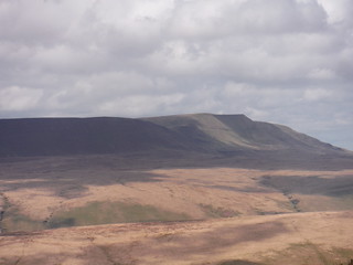
The Black Mountain (Y Mynydd Du)
SWC Walk 307 - Fforest Fawr Traverse (Craig y Nos to Llwyn-y-celyn)
May-17 • thomasgrabow on Flickr
swcwalks swcwalk307 walkicon 39314618494

Forest in Bowl below Fan Gyhirych
SWC Walk 307 - Fforest Fawr Traverse (Craig y Nos to Llwyn-y-celyn)
May-17 • thomasgrabow on Flickr
swcwalks swcwalk307 walkicon 26151493398

View from Bwlch y Duwynt
SWC Walk 307 - Fforest Fawr Traverse (Craig y Nos to Llwyn-y-celyn)
May-17 • thomasgrabow on Flickr
swcwalks swcwalk307 walkicon 28245065079

Pen y Fan and Corn Du beyond Fan Dringarth
SWC Walk 307 - Fforest Fawr Traverse (Craig y Nos to Llwyn-y-celyn)
May-17 • thomasgrabow on Flickr
swcwalks swcwalk307 walkicon 28245004179
| Length | 21.5 km (13.3 mi), with 947/830m ascent/descent. For an alternative finish at the Storey Arms Outdoor Centre bus stop see below Walk Options. |
|---|---|
| Toughness | 8 out of 10, with 6 ½ hours walking time. |
| Maps | OS Explorer: OL12 (Brecon Beacons National Park)
OS Landranger: 160 (Brecon Beacons) Harvey Superwalker XT25: Breacon Beacons West/Bannau Brycheiniog Gorllewin Harvey British Mountain Map: Breacon Beacons/Bannau Brycheiniog |
| Walk Notes |
This is a traverse of the dramatic massif of the Fforest Fawr (‘The Great Forest’, with ‘Forest’ here denoting a former Royal Hunting Ground, rather than an area full of trees), one of the least frequented parts of the Bannau Brycheiniog (Brecon Beacons) National Park, linking the Black Mountain to the west with the Central Brecon Beacons to the east.
An alternative finish at the Storey Arms Centre bus stop follows the Craig Cerrig-Gleisiad in a southerly direction and then the Craig y Fro escarpment high above the A470. |
| Walk Options |
An alternative route through the high plateau (adds 1.1 km) follows the Beacons Way between Penwyllt Quarry and Fan Dringarth, through the Ogof Ffynnon Ddu National Nature Reserve of Shake Holes and caves and along Sarn Helen (an old Roman Road) past an ancient standing stone (Maen Madoc) and an old Roman Camp.
|
| Travel |
Craig y Nos bus stop, map reference SN 840 153, is 249 km west of Charing Cross, 209m above sea level and in the Tawe Valley (Cwm Tawe), Llwyn-y-celyn bus stop, map reference SN 972 226, is 15 km north east of Craig y Nos, 10 km south west of Brecon and 326m above sea level. Both are in Powys, Wales.
Saturday Walkers’ Club: This walk is not recommended as a daywalk from London, but when based in the area for a longer stay. Accommodation is available in Craig y Nos, nearby in Glyntawe or Pen y Cae, and further along the bus lines in Ystradgynlais and Sennybridge or Brecon and Merthyr Tydfil. |
| Lunch |
Picnic |
| Tea |
YHA Brecon Beacons Llwyn y celyn, Libanus, Brecon, Powys, LD3 8NH (01874 622 485). The Youth Hostel is located 200m down a lane opposite the bus stop at the walk’s finish and serves hot and cold drinks. It is licensed. Meals are served in the evening. |
| Brecon Beacons/Bannau Brycheiniog |
The Brecon Beacons/Bannau Brycheiniog National Park is in south Wales. It consists of bare, grassy, glacial mountains, with north facing escarpments. Its peaks, just shy of 1,000m (3,000ft), are the highest mountains in the southern UK. The national park is also noted for reservoirs, and the Dan yr Ogof caves. Its 4 mountain areas, from west to east are:
|
|---|---|
| Mountain Safety |
This is a challenging but achievable walk in good weather, even for young children, but it is in remote exposed mountain areas. It is possible to twist an ankle on any walk, and it will take hours for mountain rescue to drive to the trailhead, then climb the mountain, to reach you. So:
|
| Welsh Glossary |
aber: estuary, confluence, river mouth; afon: river; affwys: abyss; allt: hillside, cliff; aran: high place; ban/fan/bannau (pl): peak/beacon/crest, hill/mountain; big: peak; blaen: source of river, head of valley; bod: dwelling; bre: hill; bron: hill-breast; bryn: hill; bwlch: gap/col/pass; cadair: chair; cae: field; caer/gaer: stronghold, fort; capel: chapel; carn/garn/carnedd/garnedd: cairn, heap of stones, tumulus; carreg/garreg: stone, rock; castell: castle; cefn: ridge, hillside; celli: grove/copse; cerwyn: pot-hole; cist: chest; clog/clogwyn: cliff; clun: meadow; clwyd: hurdle/gate; clydach: torrent; coch/goch: red; coed: wood; craig/graig: rock; crib/cribyn: crest, ridge, summit; crug: mound; cul: narrow; cwm: hanging valley/corrie/bowl/dale; cyfrwy: ridge between two summits (saddle); ddinas: fort; dibyn: steep slope, precipice; dim: no; din: hill-fortress; disgwylfa: place of observation, look-out point; dôl: meadow; du/ddu: black, dark; dwfr/dŵr: water; dyffryn: valley; -dyn: fortified enclosure; eglwys: church; eira: snow; eisteddfod: meeting-place, assembly; esgair: ridge; fach/bach: small; fawr/mawr: large; fechan: smaller; ffald: sheep-fold, pound, pen, run; ffordd: way, road; ffridd: pasture; ffrwd: stream, torrent; ffynnon: spring/well; gallt: wooded hill; ganol: middle; garth: promontory, hill, enclosure; glan/lan: river-bank, hillock; glas: green (when referring to grass, pasture or leaves), blue (when relating to the sea or air); glyn: deep valley, glen; gors: bog; gorsedd: tumulus, barrow, hillock; gwyddfa: mound, tumulus; gwylfa: look-out point; gwyn/gwen: white; gwynt: wind; hafn: gorge, ravine; hafod: summer dwelling; hen: old; hendre(f): winter dwelling, old home, permanent abode; heol: road; hesgyn: bog; hir: long; is: below, lower; isaf: lower/lowest; llan: church, monastery; llawr: level area, floor of valley; llech: slab, stone, rock; llther: slope; lluest: shieling, cottage, hut; llwch: lake, dust; llwybr: path; llwyd: grey, brown; llwyn: bush, grove; llyn: lake; llynwyn: pool/puddle, moat; maen: stone; maes: open field, plain; mawn: peat; mawnog: peat-bog; melyn: yellow; merthyr: burial place, church; moel/foel: bare, bald/bare hill; mynydd: mountain, moorland; nant: brook/stream, dingle/glen; neuadd: hall; newydd: new; ogof/gogof: cave; pant: hollow; parc: park, field, enclosure; pen: head, top/end, edge; penrhyn: promontory; pentre(f): homestead, village; perfedd: middle; perth: bush, brake, hedge; plas: hall, mansion; pont/bont: bridge; porth: gate/gateway, harbour/bay/landing-place/ferry; pwll: pit, pool; rhiw: hill, slope; rhos: moor, promontory; rhudd: red, crimson; rhyd: ford; sarn: causeway; sgwd/rhaeadr: waterfall; sticill: stile; sych: dry; tafarn: tavern; tâl: end, top; talar: headland (of field); tan/dan: below; tarren/darren: escarpment; tir: land, territory; tor: break, gap; tre/tref: settlement, hamlet, town; twlch: tump, knoll; twll: hole, pit; tŵr: tower; twyn: hill; tŷ: house; uchaf: upper, highest; uwch: above, over; waun/gwaun: moorland, meadow; wen/wyn: white; y, yr, ‘r: the; ynys: island, holm, river-meadow; ysgol: ladder, formation on mountain-side/school; ysgwydd: shoulder (of mountain); ystafell: chamber, hiding-place; ystrad: wide valley, holm, river-meadow. |
| Profile | |
| Help Us! |
After the walk, please leave a comment, it really helps. Thanks! You can also upload photos to the SWC Group on Flickr (upload your photos) and videos to Youtube. This walk's tags are: |
| By Car |
Start Map Directions Finish Map Directions |
| Amazon | |
| Help |
National Rail: 03457 48 49 50 • Traveline (bus times): 0871 200 22 33 (12p/min) • TFL (London) : 0343 222 1234 |
| Version |
Nov-23 Thomas G |
| Copyright | © Saturday Walkers Club. All Rights Reserved. No commercial use. No copying. No derivatives. Free with attribution for one time non-commercial use only. www.walkingclub.org.uk/site/license.shtml |


Walk Directions
Full directions for this walk are in a PDF file (link above) which you can print, or download on to a Kindle, tablet, or smartphone.
This is just the introduction. This walk's detailed directions are in a PDF available from wwww.walkingclub.org.uk