Fleet Circular walk
Varied heathland and woodland containing some unusual features, returning alongside the Basingstoke Canal.
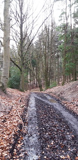
20200208_115209
Fleet circular near Beacon Hill
Feb-20 • sylvcummins on Flickr
swcwalks swcwalk318 49515415283

20200208_124233
Fleet circular, view of Ewshott village
Feb-20 • sylvcummins on Flickr
swcwalks swcwalk318 49515417458
| Length |
Main Walk: 19½ km (12.1 miles). Four hours 30 minutes walking time. For the whole excursion including trains, sights and meals, allow at least 8½ hours. |
|---|---|
| OS Maps |
Explorers 145 & (for a short section in mid-afternoon) 144. Fleet, map reference SU816553, is in Hampshire, 9 km E of Basingstoke. |
| Toughness |
4 out of 10 (2 for the Substitute Walk). |
| Features |
To motorists this walk's title will doubtless conjure up fond images of Fleet Services on the nearby M3, so to avoid disappointment it is worth stating at the outset that the route does not go near this iconic location (or indeed within earshot of the motorway). Instead a path from the station leads straight into Fleet Pond Nature Reserve, an attractive area of heathland and woodland surrounding the large pond visible from the railway line. The route follows the perimeter path around its western and southern sides and then enters a large military training area (see below for information about possible access restrictions). The long section across these military lands goes past the north-western corner of Tweseldown Racecourse, which closed for steeplechase racing in 2012 but is still used for cross country eventing. The terrain gradually becomes hillier and the route takes in one of the more unusual features to be found on a walk in south-east England: a path alongside a water channel cut into the side of Beacon Hill, faintly reminiscent of a Madeiran levada. The walk's only significant climb takes you over this hill and down to a possible pub lunch in the village of Ewshot. On older OS maps it looks as if there is more MoD land to cross, but the barracks at Crookham Park have been sold off and the walk goes through a new landscaped park created by the housing developers. After a rather nondescript trek around the outskirts of Church Crookham the walk goes past the small Zebon Copse Local Nature Reserve to begin a long stretch alongside the Basingstoke Canal. There is a solid mass of housing between this point and Fleet station, but this is not so obvious from the towpath. Although there are houses and gardens on both sides for much of the way, and occasional road noise, the mature trees lining the canal's winding course make this a surprisingly pleasant route. A welcome bonus is the presence of a highly regarded canalside pub, in a fine location for a late lunch or mid-afternoon refreshment. The final section of the walk is along the edge of the MoD land and back through Fleet Pond Nature Reserve, this time around the eastern and northern sides of the pond. The sections of this walk around Fleet Pond and the Forest of Eversley overlap with the middle part of the Farnham to Blackwater walk (#160), a longer exploration of the military lands in the area. |
| Access Restrictions |
A large part of this walk is through the Aldershot and District Military Lands. According to the Byelaws which are displayed at all its entrances, public access for recreational purposes is permitted at all times when the area is not being used by the military. In practice access used to be freely available at nearly all times, but in 2018 a large area of heathland between Aldershot Road and Bourley Road was fenced off by the MoD. There are several pedestrian gates into this area but these are often padlocked with “Military Training in Progress” signs. Although a route across this heathland would be an attractive feature, the uncertain access arrangements have made that impracticable and so the walk skirts around it. If military training is concentrated in this area it should reduce the chance of an encounter on the walk route, but you must be prepared to detour around any training exercise if ordered to do so. A separate issue is that for health & safety reasons much of the MoD land is closed to the public for two weeks in July in even-numbered years, before and during the biennial Farnborough Air Show. The roads and canal towpath under the airfield's flight path are closed too. As any detour would be too extensive no alternative route has been specified, so the Main Walk should not be attempted at this time. |
| Walk Options |
There are three places along the walk route – Tweseldown Racecourse, Beacon Hill and Crookham Park – where navigation could be difficult, or access restricted for some reason. In these places the main route takes a straightforward course along broad paths and tracks, but walkers with map-reading skills are encouraged to attempt the more interesting alternative routes. There are also directions for two short detours: a longer exploration of Zebon Copse, and to Sandy Bay at the southern tip of Fleet Pond. If you come across an unexpected closure of the MoD land south of Norris Bridge there are no really good options. Directions are given for a Substitute Walk to the Fox & Hounds, but although the OS map shows that its route along the edge of another piece of MoD land is outside the restricted area, this is not how it looks on the ground. In addition there are only a few oases of woodland to break up some long stretches along residential streets in Church Crookham. The directions also mention another less-than-ideal alternative, a long out-and-back section along the canal towpath to the same pub. |
| Transport |
Fleet station is on the main line between Woking and Basingstoke, with a half-hourly service from Waterloo (hourly on Sunday mornings) taking 56 minutes. Fleet used to have an additional hourly fast service but this was discontinued in 2019. There are few bus services in the area, but if you want to abandon the walk in mid-afternoon Stagecoach 10 runs every 90 minutes (Mon–Sat) from a stop outside the Fox & Hounds pub in Church Crookham to Fleet station. If driving, Fleet has a large station car park which costs £3.50 at off-peak times but £9.90 before 2pm Mon–Fri (2023). |
| Suggested Train |
Take the train nearest to 09:40 from Waterloo to Fleet. If you plan to have an early lunch at one of the first two pubs (see below), start an hour later. |
| Train Times |
|
| Timetables |
|
| Lunch |
There are four pubs on or close to the walk route, but the best ones are not well placed. If you start late and are prepared to stop for lunch after just 4¼ km, The Foresters (01252-616503) serves relatively expensive ‘modern British’ food all day; it is more of a restaurant than a pub, however, with table service. After a further 1¼ km a short detour would take you to The Tweseldown (01252-266657) on the main road by the old racecourse, which serves standard pub food all day. The pub closest to the walk's midway point is in the quiet village of Ewshot, after 8¾ km. However, The Windmill (01252-850439; food to 2.30pm Wed–Fri, later at weekends) has not always been open and at best has a rather simple food menu (burgers, pizza, etc), so it would be advisable to call ahead to check that it is serving food. If you can hold out for another hour the last pub on the route (after 14 km) is worth the wait: the Fox & Hounds (01252-663686) is in an idyllic location alongside the canal and serves very good and reasonably-priced food until 2pm weekdays, all afternoon at weekends. |
| Tea |
If you have had an early lunch stop the Fox & Hounds (see above) is well placed for a mid-afternoon refreshment stop. At the end of the walk there are few places near Fleet station, which is some way from the town centre. A small Café Destino in the station concourse should be open on weekdays, but is likely to be closed by the time you get there on a weekend. The most convenient place nearby is The Station (01252-614839), an Ember Inns pub just across the main road which is open all day. For a more characterful experience a ten-minute walk along the A3013 to the north of the station would bring you to the Heron on the Lake (01252-812522), a ‘nautical inspired pub’ with a waterside terrace overlooking the small northern part of Fleet Pond; sadly, there is no equivalent place closer to the walk route on the main part of the pond. |
| Profile | |
|---|---|
| Help Us! |
After the walk, please leave a comment, it really helps. Thanks! You can also upload photos to the SWC Group on Flickr (upload your photos) and videos to Youtube. This walk's tags are: |
| By Train |
Out (not a train station) Back (not a train station) |
| By Car |
Start GU51 3QY Map Directions |
| Amazon | |
| Help |
National Rail: 03457 48 49 50 • Traveline (bus times): 0871 200 22 33 (12p/min) • TFL (London) : 0343 222 1234 |
| Version |
Aug-23 Sean |
| Copyright | © Saturday Walkers Club. All Rights Reserved. No commercial use. No copying. No derivatives. Free with attribution for one time non-commercial use only. www.walkingclub.org.uk/site/license.shtml |

Walk Directions
Click the heading below to show/hide the walk route for the selected option(s).
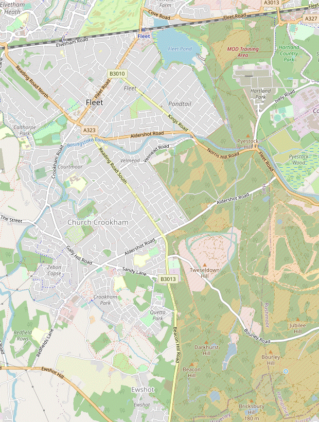


 Walk Map
©
Walk Options
Click on any option to show only the sections making up that route, or the heading above to show all sections.
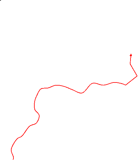
- Main Walk (19½ km)
Walk Directions
Click on any section heading to switch between detailed directions and an outline, or the heading above to switch all sections.
- Fleet Station to Norris Bridge (3 km)
- Follow the perimeter path around the western and southern sides of Fleet Pond to the point where the Gelvert Stream enters the Nature Reserve. Continue on the woodland path heading south-east through the MoD Training Area to Pyestock Hill. Go out onto Ively Road and cross the Basingstoke Canal on the Norris Bridge roundabout.
- Go out through the station's concourse and straight ahead across its forecourt. On the far side go between railings and turn left onto a tarmac path with a purple waymarker for the Brenda Parker Way?.
-
You soon pass an information panel for Fleet Pond Nature Reserve? and the path crosses a water channel on a wooden footbridge. Immediately afterwards, just past steps down from the station car park, turn right at a junction onto a waterside path heading S alongside Fleet Pond.
You will be following sections of the yellow and blue waymarked routes around this reed-fringed pond for over 1½ km.
- Ignore all paths off to the right, at one point crossing Brookly Stream on a wooden footbridge. At the end of a 150m stretch alongside a residential street (Fugelmere Road) fork right where the two waymarked routes split. In 350m turn left with the blue route at a junction; soon a short stretch along a boardwalk brings you to a major path junction in front of the Gelvert Stream.
- Cross the stream on a wide wooden footbridge and turn half-right onto a broad path (not the path alongside the stream), leaving the Nature Reserve and entering the signposted MoD Training Area. In about 300m the woodland path turns half-right. In a similar distance, just before the path starts to climb more steeply, turn right at a path junction.
-
At the next two junctions fork left to go gently uphill, heading S. In about 300m you will be coming out onto a road which you will soon be able to hear off to the left. After the path levels out and merges with another from the left, keep left at all subsequent junctions to avoid paths dropping down to the canal towpath.
You will end up taking one of these paths if forced to switch to the Substitute Walk.
- The leftmost path soon swings left and goes out through a narrow gap. Turn right and go along the footway past a large roundabout, high above the Basingstoke Canal?. Cross the A323 carefully at the designated crossing point ahead. Follow the footway briefly round to the left, where there are a couple of narrow gaps in the bushes into another part of the MoD Training Area.
- Norris Bridge to Brock's Hill (1½ km)
- Enter another part of the MoD Training Area and take the track heading south-west through the Forest of Eversley. At the end continue parallel to Aldershot Road for 300m (passing The Foresters), then turn left to cross the road. Follow a track up to a cattle grid in front of Brock's Hill.
- Go through the bushes and up the slope to the right to reach a large clearing covered in stones, making for slightly awkward walking. Take the middle of three tracks leading off it, slightly to the left, with the stones soon giving way to an easier surface. Follow the track down through the Forest of Eversley and round to the right.
- The track straightens out and goes through a more open area, with a cattle grid and side gate along the way. It gradually approaches Aldershot Road and eventually you go past another grid into a small parking area.
- Do not go out to the road, but veer right through another gate/grid and take the leftmost path. This runs parallel to the road and soon goes past the back of The Foresters, with a gate into its car park at the far corner if you want an early lunch stop.
- To continue the walk, carry on past the pub for 150m and then turn left through a metal kissing gate. Cross the road carefully and go past a metal vehicle barrier onto a track curving left through the trees, into another part of the MoD Training Area. You soon emerge into an open area of heathland and go up to a cattle grid, where the main track continues towards the low hill ahead.
- Brock's Hill to Parkhurst Hill (2 km)
- As the route across the heathland ahead is problematic, turn right in front of the cattle grid and go up to the belt of trees surrounding Tweseldown Racecourse. Follow a path around its north-western corner (or perhaps cut across it if no event is taking place). Continue on a grassy strip along its western side and keep ahead through a small wood to a T-junction with a track in front of Parkhurst Hill.
- To continue the walk, therefore, turn right in front of the cattle grid onto a broad path alongside a low wire fence. In 125m this forks in front of a belt of trees, with the left-hand path leading through the trees to a gate onto Tweseldown Racecourse?.
-
Main route
- To skirt around the racecourse ignore the path into the trees and fork right. Keep the trees on your left for 600m, initially heading WSW but veering left a couple of times. Eventually you go through a metal gate into a parking area and out onto Bourley Road.
-
Alternative route (−100m)
- To cut through the racecourse take the path through the trees to a metal kissing gate leading onto the site. Providing access is permitted, go across the old racetrack and through a gap in the hedge opposite.
- Veer right and take any convenient route past the horse jumps, heading roughly SW and essentially cutting off a corner of this large site. Aim for a gap between the white fence rail surrounding the pavilion area and a new wooden fence to its right, both around 250m away.
- At this gap veer right through a gate in the wooden fence and take the left-hand of two faint grassy paths towards the tree boundary. Go through a gap and follow a short path through these trees into a parking area. Turn left to come out onto Bourley Road.
- Unless you want to visit a nearby pub, cross the road and continue on the narrow path opposite the parking area, underneath power lines and heading SSE.
-
Detour to The Tweseldown pub (+250m)
- Instead of taking the path turn right and go along Bourley Road to its junction with the B3013; the pub is on the left.
- Either return the same way and turn right onto the path opposite the parking area, or turn left out of the pub onto the main road and then cut diagonally across a playing field to join this path 150m further along.
- Continue on the path underneath the power lines, with a long belt of trees on the left. At the end of these trees there is a view of the old racecourse control tower on a low hill off to the left (with Farnborough Airport beyond). Keep ahead on the path for a further 500m, ignoring ways off.
- Where the power lines turn 90° right keep ahead across a stony track onto a woodland path, which in 200m comes to a T-junction with another stony track. There is a wide stile in the low wire fence opposite and several paths leading up the wooded slope ahead.
- Parkhurst Hill to The Windmill, Ewshot (2¼ km)
-
For a route along main tracks and paths, turn right onto the track. Take the first left, then keep right at junctions to skirt around the eastern side of Beacon Hill, eventually going up a slope to meet the levada running along the hillside.
- Alternatively, take a narrow path across Parkhurst Hill and straight up the side of Beacon Hill to the levada.
-
Main route
- Ignore the stile and turn right onto the broad track, heading SW. In 250m turn left at a track junction, going past a cattle grid.
- The track goes over a low rise and swings left downhill, in 200m coming to a three-way track junction. The main route continues on the track slightly to the right; the narrow path going up Beacon Hill on the right is the alternative route at [?·c] below.
- To stay on the main route, take the broad track heading SE. There are some more tempting side paths up Beacon Hill, but for the simplest route stay on the track and turn right at a four-way track crossing after 225m.
-
In a further 250m keep right at another track junction, now climbing steadily. In 125m you reach a level path alongside a water channel at an oblique crossing, shortly before the track swings left. Bear left to go alongside this levada?, merging with the alternative route.
If this path is blocked for some reason you could stay on the main track to the ridge at the top of the hill, going parallel to the B3013 (Beacon Hill Road) on the right for the final 100m.
-
Alternative route (−200m)
- For the more direct route go straight across the track and over the stile. Take the right-hand of two narrow paths up the wooded hillside, initially heading S and bending right at the top. Keep right at a path junction, avoiding a path dropping down to the left.
- In about 100m the path swings left across a dip and up the other side, then drops steeply down to emerge from the trees at a three-way track junction. The alternative route continues on the narrow path opposite, while the broad track on the left is the main route at [?·c] above.
- To stay on the alternative route, take the narrow and potentially muddy path climbing steeply up Beacon Hill (but beware off-road cyclists, who like to descend en masse at breakneck speed). Follow any of the sets of tyre tracks up the hillside.
- About 100m inside the treeline you come to a level path alongside a small water channel. Turn left to follow the contours of the hillside alongside this levada?.
- You will see some broad stony tracks in the valley below. In about 400m go straight across one of these at an oblique crossing, merging with the main route.
- Follow the meandering levada along the wooded hillside, heading roughly S. In 350m you meet another broad stony track and turn right onto it. The track winds its way uphill for 250m to the ridge at the top, with the B3013 (Beacon Hill Road) behind the trees opposite.
- At the top turn left at a T-junction, go past a cattle grid and turn right to come out onto the road. Cross the B3013 with great care and take the signposted bridleway just off to the left.
- Follow this track steadily downhill for 400m and continue along a short street into the village of Ewshot. You soon reach The Windmill pub (a possible refreshment stop) on the right.
- The Windmill to Ewshot Lane (1¾ km)
-
Go down Church Lane, across Tadpole Lane and up past the Village Hall into Naishes Lane SANGS. For a straightforward route through this country park take the path straight ahead, then in 500m turn left onto a sandy horse ride heading south-west and skirting around Riddings's Copse to Ewshot Lane.
- Alternatively, make your way along grassy paths across the landscaped parkland and/or take a woodland path through Riddings's Copse at the end.
- Go downhill through the village on Church Lane. At the bottom of the hill bear right, going straight across Tadpole Lane. Go through a wooden gate leading to the Village Hall and make your way around the right-hand side of the building.
- Go through the car park and up a grassy slope beside a children's playground. At the top pass to the left of a tennis court and go through a wooden gate into Naishes Lane SANGS?, with an information panel about this country park. Take the middle path, straight ahead.
-
Main route
- Stay on the main path for 500m, going steadily downhill and through several wooden ‘SANGS’ gates along the way. After a stretch of boardwalk go through a side gate to the right of a wooden fieldgate and turn left onto a sandy horse ride, which you now follow for the remainder of this section.
- The ride soon crosses Naishes Lane and turns left to go alongside it for 150m, then bears right up a slope (where the alternative route joins from a side gate on the left). Carry on alongside a wood (Ridding's Copse), passing several pillboxes in the trees. Just before the ride turns sharply right at the bottom corner of the wood, you could switch to the alternative route at [?·g] below.
- To complete this section on the main route stay on the horse ride as it turns right to continue alongside the wood. At the far end the ride turns left and zig-zags past barriers onto Ewshot Lane.
-
Alternative route (−150m)
- For a more complicated route go along the main path for just 75m, then fork left onto a narrow side path through a belt of trees. This comes to a wooden gate leading out onto open grassland, with a fine view ahead of the Hampshire Downs.
- Keep ahead briefly on a grassy path and then fork right to head N over a low mound. Follow the path as it curves left past three pillboxes, then down to the right towards a belt of trees.
- Go through a wooden gate in these trees and fork left onto a grassy path going alongside them, heading NW. In 100m fork right and follow the path round to the right, still with a tree boundary on your left.
- In around 100m turn sharp left through a gap in these trees. Follow the path down a bank in the tree boundary and out onto Naishes Lane, with a sandy horse ride (the main route) on the far side.
- Cross the lane (slightly to the left) and go through a gap in the trees under power lines into a meadow. Follow a grassy path alongside the horse ride for 50m, then go through a wooden gate to join it.
- Ignore a gate opposite and turn left onto the ride. Follow it up a short slope and then gently downhill alongside a wood (Ridding's Copse), passing several pillboxes in the trees on the right. Shortly before the ride turns sharply right at the bottom corner of the wood you could switch to the main route at [?·c] above.
- To complete this section on the alternative route turn right through a wooden gate to go past one of these pillboxes into the wood. Follow a narrow path through the lightly wooded area, staying roughly parallel with the horse ride off to the left.
- Near the far side of the wood fork left at a path junction to rejoin the horse ride via another gate. Turn right onto the ride, which soon turns left and zig-zags past barriers onto Ewshot Lane.
- Ewshot Lane to Crookham Swing Bridge (1¾ km)
- Turn right briefly onto Ewshot Lane and take a rather awkward footpath heading north-west across a field. Keep ahead through Redfields Business Park to reach Redfields Lane. Maintain direction along Watery Lane and continue along the southern edge of (or detour through) Zebon Copse to Crookham Swing Bridge on the Basingstoke Canal.
- Turn right briefly onto the lane. Where it bends right in front of a metal gate leading into a yard, take the signposted footpath in a belt of trees between the yard and the lane. This narrow and potentially overgrown path soon turns half-left to stay alongside the yard's metal fence.
- In 100m the path emerges into a field. Continue along a fenced-off section on its right-hand edge to a stile in the far corner, where a short path through the tree boundary takes you into Redfields Business Park.
- Go straight ahead on the main road through this business park for 250m (still on a right of way). At the end cross Redfields Lane carefully and turn right, then veer left into Watery Lane. Follow this long straight lane for 400m, ignoring ways off.
- After the last house on the right the path splits into two parallel routes. Avoid the signposted bridleway ahead (which is invariably flooded) and turn right to cross the stream. On the other side turn left onto a footpath running along the other side of the stream.
- In 175m the two routes merge and you rejoin the bridleway, ignoring the continuation of the footpath off to the left. In 200m go straight across an access road, staying on the bridleway. A little further on you pass a sign welcoming you to Zebon Copse?, then come to a path junction in front of an information panel about it.
- Unless you want to take a short detour through this nature reserve, follow the main path round to the left. You soon pass a “Bats” information panel and come to Crookham Swing Bridge on the Basingstoke Canal.
-
Detour through Zebon Copse (+400m)
- For a short loop through the nature reserve, turn right at the first information panel. In 100m turn left onto a narrow side path through this wet woodland, partly on stretches of boardwalk. In 125m turn left at a path junction by a “Mire” information panel.
- The next stretch of boardwalk leads to and curves around a small pond with a wooden viewing platform. The path leaves the reserve by a “Bats” information panel, where you bear right onto a broad path leading to Crookham Swing Bridge on the Basingstoke Canal.
- Norris Bridge to Basingbourne Park (3 km)
- Return to Pyestock Hill and take one of the paths going down to the canal. Turn right and go along the towpath to the two Pondtail Bridges. Cross the canal on the second bridge and take a short path off Velmead Road into the MoD Training Area. Turn right and go along its boundary to the north-western corner. Turn left onto a path outside the area, then turn right onto Florence Road. Go all the way along this street and then Basingbourne Road to a roundabout in Church Crookham. Keep ahead briefly and turn right into Basingbourne Park.
- For the Substitute Walk keep left inside the woodland, which will take you onto a path dropping down to the canal. Turn right onto the towpath (away from the high road bridge) and follow it for 750m to the two road bridges at Pondtail.
- Go under the first road bridge (carrying the A323) and bear right up a ramp onto the second. Cross over the canal, go past vehicle barriers and bear left onto Velmead Road. In 50m, before it comes out onto the A323, veer right onto a short path through trees to a metal kissing gate, an entrance into another part of the MoD Training Area.
- If access to the MoD land is permitted, go through the kissing gate and turn right to go all the way along a broad grassy strip on its boundary. In 700m go out through a gate beside a cattle grid in its north-western corner and turn left onto a path between the MoD land and houses.
- In 125m turn right past a vehicle barrier into the end of a residential street (Florence Road), the start of 1 km of road walking. Go all the way along this quiet street, cross over the B3013 (Reading Road South) and continue on Basingbourne Road opposite.
- After 600m along this somewhat busier street you come to a roundabout. Leave the main road (which turns left) by going straight ahead for a further 50m. Turn right into a short street in front of Basingbourne Park and in 50m turn left into this small recreation ground.
- Basingbourne Park to Crookham Swing Bridge (2 km)
- Follow a path across the playing field into Basingbourne Heath. Continue along the woodland path, curving round to the left to leave on its southern boundary. Turn right onto a path leading via Award Road to Gally Hill Road. Turn right briefly onto this road, then turn left onto a cycle path through a housing development to Zebon Copse. Take any path through this small nature reserve to Crookham Swing Bridge on the Basingstoke Canal.
- Follow the tarmac path between a children's playground and a pavilion, then round to the right towards an exit on the right-hand side of the playing field, passing an information panel for Basingbourne Heath?. Cross a stream and turn left, staying on the main path alongside the stream on the woodland edge.
- In 50m keep left where the path forks. At the next junction keep left again, recrossing the stream and veering left to follow its course through the wood. Carry on in this direction on the main path (criss-crossing the stream a few times) to come to the edge of the wood, with a cul-de-sac ahead (Heather Drive).
- Do not go out onto the road but turn right onto a tarmac path just inside the wood. At the end of the wood keep ahead for a further 250m, at first on a fenced path and then a residential street (Award Road). At the far end turn right briefly onto Gally Hill Road, then in 50m turn left onto a cycle path heading SW.
- Follow the surfaced path through a new housing development and then across an open space. On the far side cross a residential street (Brandon Road) and veer right to continue on the cycle path, soon with a wood behind a fence on your left. In 200m turn left at a path junction into this wood, soon coming to a sign welcoming you to Zebon Copse?.
-
Main route
- Turn right by the sign onto a side path through the woodland, with a stretch of boardwalk through a more open area. In 200m turn right at a path junction by The Mire, described on an information panel.
- …
-
Alternative route
- Stay on the cycle path for a further 75m to the far side of this small wood. Turn right onto a path leading through a gate into another part of the reserve.
- In 200m keep ahead where the path merges with a broad path by an information panel about the reserve. …
- Crookham Swing Bridge to Fleet Pond Nature Reserve (5½ km)
- Cross the canal and turn right onto its towpath, heading north. Follow it under Malthouse Bridge and Coxheath Bridge to reach the Fox & Hounds pub on Crookham Road. Continue along the towpath, which swings right to head east as it goes under Reading Road Bridge. 200m after the two Pondtail Bridges, turn left off the towpath and follow a path around two sides of a residential area, Pondtail. Opposite Pondtail Road fork right onto a path heading north, re-entering Fleet Pond Nature Reserve by the Gelvert Stream.
-
Go across the low bridge and turn right for the start of a long stretch along the tree-lined towpath, initially heading N and always with the canal on your right. In the first 1 km you pass under Malthouse Bridge and then Coxheath Bridge. In a further 600m you come to the canalside garden of the Fox & Hounds pub, a tempting refreshment stop.
If you want to finish the walk here, there is a stop across the road from the pub for buses to Fleet station.
-
Continue along the towpath, still heading N with the canal on your right. After a long slow turn to the right you are heading E and come to a small patch of open ground with an information panel about the canal's history.
Fleet town centre (with pubs and coffee shops) is 350m off to the left along the A323. The station is a further 1¾ km away but several bus routes go along the A3013.
- After ducking under the very low Reading Road Bridge (carrying the B3013) a further 1½ km along the towpath brings you to the Old and New Pondtail Bridges in quick succession (the latter carrying the A323).
- Continue along the towpath for 175m after the second of these bridges, still with the canal on your right. After passing the last house turn left onto a long straight path between the residential area and a wood. In 350m, at the end of the houses, turn left to continue with an area of scrubland on your right.
-
In a further 350m, with a wood ahead and Pondtail Road on your left, fork right through a wooden side gate to go along the edge of the scrubland, with the wood on your left. At the far end go through another side gate to re-enter Fleet Pond Nature Reserve.
You should recognise this path junction from your outward route.
- The Nature Reserve to Fleet Station (1¾ km)
-
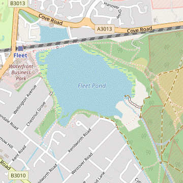 Go across your outward route and follow the path alongside the stream. In 350m either turn right across a footbridge, or detour ahead to Sandy Bay and rejoin the main path a little further ahead. Continue along the perimeter path around the eastern and northern sides of Fleet Pond to reach the station, with possible detours to the nearby Station pub or the Heron on the Lake on the small northern part of Fleet Pond.
-
Go straight ahead onto the broad woodland path running alongside the Gelvert Stream, crossing over your outward route and now back on the blue waymarked route. In 350m the suggested route is to turn right to cross the stream on a wooden footbridge and continue on a broad path.
If you are not in a hurry the detour below leads to a pleasant spot at the edge of Fleet Pond.
-
Detour to Sandy Bay (+300m)
- Go straight ahead past the footbridge, staying on the blue route beside the stream and soon merging with the yellow route from the left.
- The path eventually swings right and crosses the stream on another footbridge, coming out into a small open area with a view across Fleet Pond from the water's edge.
- Return on the path to the left of the one you arrived on. At the end of this long stretch of boardwalk turn left to rejoin the main route.
- The broad path swings right to cross another stream, then passes an information panel about Sandy Hill Copse. You could remain on this long straight path heading NW, but the suggested route is to veer right onto one of the paths going up the short slope. This leads to a slightly higher path alongside a wooden fence, never far from the straight path below.
- Keep ahead through a picnic area, leaving the blue and yellow routes and joining the shorter red route. The woodland path gradually approaches the railway line and you swing left in front of it, in a small grove containing more information panels.
-
Follow the perimeter path between Fleet Pond and the railway?, soon with the station's long car park on your right. You could go up one of the sets of steps and cut through it to the station, but it is nicer to stay on the perimeter path. Eventually you retrace a short stretch of your outward route and come to a gap on the right into the station forecourt.
If you want to visit a nearby pub before catching a train, follow the detour below.
-
Detour to The Station pub (+250m)
- Continue along the tarmac path to a roundabout. The pub is off to the right on the far side, so cross the main road with great care and go through the pub's car park.
- Return via the roundabout and the station approach road.
-
There is a Café Destino inside the station. For trains to London, cross the footbridge to Platform 1.
- The Brenda Parker Way runs for 125 km across north Hampshire, from Aldershot to Andover. It was set up in 2011 to commemorate a prominent local member of the Ramblers.
- Fleet Pond is thought to have been created as a fishery for local monks at the end of the 12thC. It became part of the military estate in 1854 and the area was used for military training until it was relinquished by the MoD in 1972. It was declared a Site of Special Scientific Interest (SSSI) in 1954 and a Local Nature Reserve in 1977.
- The Basingstoke Canal was completed in 1794, connecting the town with the River Thames via the Wey Navigation at Byfleet. After commercial traffic switched to the railways the canal became increasingly derelict, but an ambitious 18-year restoration project culminated in the 32 miles from Greywell to the Wey Navigation reopening in 1991.
- Tweseldown Racecourse was the venue for the equestrian dressage and eventing competitions in the 1948 Olympics.
- The levada on Beacon Hill was built to channel water down the valley to reservoirs which supplied the army barracks.
- Naishes Lane SANGS is the designated “Suitable Alternative Natural Green Space” for a new housing estate being developed on the site of barracks once occupied by the Gurkhas. The World War Ⅱ pillboxes scattered across the site were part of a long defence line across southern England.
- Basingbourne Heath is mainly woodland but it contains two small pockets of lowland heathland, remnants of the habitat which once covered much of southern England. The nature reserve is designated as a Site of Importance for Nature Conservation (SINC).
- Zebon Copse is a local nature reserve of wet woodland close to the Basingstoke Canal, with good displays of wildflowers in spring and summer.
- The London & Southampton Railway was constructed in the 1830s on an embankment across the northern part of the pond, hence the smaller pond on the other side. The station (then called Fleet Pond Halt) was built to serve the day-trippers who came for picnics and swimming in summer, and for ice-skating in winter.
If this area is closed you will have to abandon the Main Walk. If you want to switch to the Substitute Walk, retrace your steps into the woodland above the canal and go to §G.
A 2 km stretch across this attractive heathland was the intended route for this walk, but in 600m you would come to the start of the fenced-off area which is now often closed to public access. You could detour ahead for 200m and gaze wistfully across the heathland from Brock's Hill, but to avoid complications the route steers well clear of this military training area.
At the time of writing a notice by the gate confirmed that access across the racecourse was permitted whenever it is not being used for an equestrian event, so if you are feeling adventurous you could try the alternative route in [?].
For simplicity the main route mostly follows broad tracks and paths to Beacon Hill, including 350m alongside a winding levada. The alternative route in [?] takes a narrow path straight over the low hill ahead, crosses over the main route and climbs steeply up Beacon Hill for a longer stretch alongside this unusual feature. You could switch between the two routes at this crossover point.
For simplicity the main route is on broad well-used paths. The more adventurous alternative route in [?] has better views, but be aware that the path layout might have been affected by construction work for a new pipeline.
Continue the directions at §I.
If this entrance is also locked you will have to return to the canal. For a less-than-ideal walk of about 12 km you could carry on along the towpath for 2½ km to the Fox & Hounds, but you would be returning the same way. To complete the walk pick up the directions in §I: at [?] from this pub or [?] if you decide to abandon the walk here.
There is a choice of routes through this small nature reserve. If the main route looks too muddy, take the alternative route in [?].
Walk Notes
» Last updated: July 17, 2023
Return to Top | Walk Map | Walk Options | Walk Directions.