Godstone to Oxted walk
Compare two magnificent yew trees in the Surrey churchyards of Crowhurst and Tandridge.

1010300048
Ancient yew in Tandridge churchyard
Oct-10 • Sean O'Neill
swcwalk2, swcwalk277, swcwalks, walkicon 5533976894366783618 P

CIMG6903
Assart, Staffhurst Wood
Nov-16 • Sean O'Neill
swcwalk135, swcwalk277, swcwalks, walkicon 6379842932342455186 P

DSCF1915
St Peter's church, Tandridge
Sep-09 • Sean O'Neill
swcwalk2, swcwalk277, swcwalks 5643804402519439586 P

DSCF1916
St Peter's church, Tandridge
Sep-09 • Sean O'Neill
swcwalk2, swcwalk277, swcwalks 5643804426486830322 P

DSCF1918
St Peter's church, Tandridge
Sep-09 • Sean O'Neill
swcwalk2, swcwalk277, swcwalks 5643804457042581458 P

1010300052
Fly agarics on Tandridge golf course
Oct-10 • Sean O'Neill
swcwalk2, swcwalk277, swcwalks 5533976952952027570 P

| Length |
Main Walk: 17¾ km (11.0 miles). Four hours 15 minutes walking time. For the whole excursion including trains, sights and meals, allow at least 8 hours. |
|---|---|
| OS Maps |
Explorers 146 & 147. Godstone station, map reference TQ362483, is in Surrey, 8 km ESE of Redhill (and 4 km south of its village). |
| Toughness |
4 out of 10. |
| Features |
Many British churchyards contain ancient yew trees and two of the largest are just 4 km apart as the crow flies, in the Surrey hamlets of Crowhurst and Tandridge. They each have girths of over 10 metres and are at least 1,000 years old, although as both have hollowed out it is impossible to date them accurately by counting tree rings. Measurement of the Crowhurst Yew's slow rate of growth over several hundred years has encouraged speculation that it is much older, perhaps even the second oldest yew tree in the UK (the oldest is reckoned to be in Fortingall, Perthshire). The Crowhurst Yew is also featured on the Oxted to Lingfield walk (#135) and the Tandridge Yew on the Woldingham to Oxted walk (#2), but this is the only walk which allows you to compare them. The walk itself is mostly through low-lying farmland (with occasional stretches of woodland) in the valley of the River Eden, but there are also good views from the low hills to the south of the river and the Greensand Ridge to the north. After a slightly scruffy start along the busy A22 and through a muddy farmyard, the walk heads east along a low ridge to the first yew in Crowhurst. After crossing the River Eden it swings north to go through Staffhurst Wood to the same lunch pub as Walk #135 on the edge of the wood. The afternoon section has been transferred from that walk's original Circular Walk option and extended to go past the second yew in Tandridge. The final stretch into Oxted is the same as Walk #2. The low-lying nature of this walk means that you will need to be prepared for muddy or waterlogged paths after wet weather. |
| Walk Options |
Two shorter endings are described, although both of these miss out the Tandridge Yew. One is a more direct route along country lanes into Oxted, the other an even shorter route to the station at Hurst Green. No buses venture down the lanes around Staffhurst Wood and so you would need to call a taxi if you wanted to abandon the walk at lunchtime. |
| Additional Notes |
An alternative start from Edenbridge was dropped in 2021 after Network Rail closed a footpath crossing on the Redhill–Tonbridge line. The route had in any case become difficult to follow where it crossed a (now abandoned) golf course. |
| Transport |
Godstone station is on a sleepy branch line with an hourly off-peak service between Tonbridge and Redhill. It is usually quicker (and cheaper) to travel out via Redhill. At the end of the walk there is a half-hourly service from Oxted (and Hurst Green) to Victoria, plus an hourly service to London Bridge (Mon–Sat). The start and finish stations are on different lines but a return to Edenbridge Stations via East Croydon is valid on the return journey from Oxted or Hurst Green as well as the outward journey to Godstone via Redhill. The Main Walk is awkward for car drivers as there is no convenient way of returning to Godstone station (which does have a small car park, “free for rail users”). At best you could park in Edenbridge between its two stations, travel out on one line and return to your car on the other. |
| Suggested Train |
Take the train nearest to 10:20 from Victoria or London Bridge to Godstone, changing at Redhill. |
| Train Times |
|
| River Levels |
|
| Lunch |
The only conveniently-placed pub for a lunchtime stop is the Royal Oak (01883-722207) on the edge of Staffhurst Wood, after 8¾ km. A “Grumpy Mole Restaurant” since November 2016, this popular country inn has an attractive garden with fine views across the Low Weald. It serves a good range of locally sourced and freshly-cooked food to 3pm, from à la carte meals to bar snacks. There are later pubs on each of the two routes into Oxted, but none if you finish at Hurst Green. A short detour off the main route would take you to the Barley Mow (01883-713770) in Tandridge, which serves food to 3pm and is 5½ km beyond the Royal Oak. You could also try one of the pubs listed below as Tea places, although these are all within 2 km of the finish. |
| Tea |
On the main walk route the Chef & Brewer Old Bell (01883-712181) is at the crossroads in Old Oxted, with two alternatives a little further down its short High Street: the George Inn (01883-713453) and the Crown Inn (01883-717853). The direct route (omitting Tandridge and Old Oxted) passes The Haycutter (01883-776955) in Broadham Green, which re-opened in Autumn 2017 after a long closure. There are several cafés and coffee shops in the main part of Oxted (but nothing near Hurst Green station). Two possible tea places in Station Road West are Robertsons at #42 (01883-712777; open daily to 5pm), a specialist coffee shop with a small tearoom at the back; and Café Papillon at 54 Station Road West (01883-717031; nominally open to 5pm Mon–Sat but may stop serving earlier; closed Sun). There is also a conveniently placed JD Wetherspoon's pub right next to the station, the Oxted Inn (01883-723440). On the other side of the station there are more places in Station Road East, including Caffè Nero at #139 (01883-730220; open to 6pm Mon–Sat, 5pm Sun); an independent coffee shop at #85, Bru & Bear (01883-818390; open to 4pm Mon–Sat, 2pm Sun); and a Costa at #62 (01883-712866; open to 5.30pm Mon–Sat, 4.30pm Sun). If you are doing one of the shorter variations as an afternoon walk, the Royal Oak (see Lunch above) serves a full afternoon tea from 3-5pm Mon–Sat. |
| Profile | |
|---|---|
| Help Us! |
After the walk, please leave a comment, it really helps. Thanks! You can also upload photos to the SWC Group on Flickr (upload your photos) and videos to Youtube. This walk's tags are: |
| By Train |
Out (not a train station) Back (not a train station) |
| By Car |
Start RH9 8EU Map Directions Return to the start: Finish RH8 9EU Map Directions Travel to the start: |
| Amazon | |
| Help |
National Rail: 03457 48 49 50 • Traveline (bus times): 0871 200 22 33 (12p/min) • TFL (London) : 0343 222 1234 |
| Version |
Jul-24 Sean |
| Copyright | © Saturday Walkers Club. All Rights Reserved. No commercial use. No copying. No derivatives. Free with attribution for one time non-commercial use only. www.walkingclub.org.uk/site/license.shtml |


Walk Directions
Click the heading below to show/hide the walk route for the selected option(s).


 Walk Map
©
Walk Options
Click on any option to show only the sections making up that route, or the heading above to show all sections.
- Main Walk (17¾ km)
Walk Directions
Click on any section heading to switch between detailed directions and an outline, or the heading above to switch all sections.
- Godstone Station to Tandridge Lane (2¼ km)
- Head south on the A22 for a short distance and then take a bridleway on the left, past a farm and round Lagham Manor. Follow the bridleway round to the left and along a low ridge, heading east and eventually coming out past Lagham Lodge Farm onto Tandridge Lane.
- Exit through the station's small car park to the A22. Turn right and go along the pavement for 200m, passing under the railway bridge. On reaching a cottage cross the main road with great care and go along a driveway towards some farm buildings, signposted as a bridleway. At the entrance go through a side gate on the right and past the farmhouse, then through a fieldgate with a blue arrow confirming the right of way.
- Follow the track across a muddy patch between two barns and round to the right, climbing gently alongside a belt of trees screening the remains of a large moat around Lagham Manor?. At the top of the slope go through a metal fieldgate and bear right across a field towards another fieldgate.
- Go through the gate into the bottom corner of a sloping field and turn three-quarters left, slanting up the field. After passing the end of a line of trees at the top maintain direction across the grass towards a gap in the hedge 100m away, which takes you onto a grassy strip between a hedge and a fence. After going through a gate this becomes a long straight tree-lined path heading E between fields, with fine views on both sides.
- At the end the path comes to a T-junction where you turn right to head S. In 50m ignore a small gate ahead and veer left through a gap in the hedge, crossing a ditch. Go through a metal gate into a large field and continue along its left-hand edge. At the far end go through another fieldgate and carry on along a grassy track, then a driveway past farm outbuildings and a few cottages to a road (Tandridge Lane).
- Tandridge Lane to Crowhurst Church (1½ km)
- Turn right briefly onto the lane and then take a footpath on the left past a fishing lake and across two fields to Ashen Plantation. Head east through the wood and continue along the top of four fields to Crowhurst church.
- Turn right and go along the roadside, taking care as there is no pavement. In 75m cross the road and go over a stile to the left of a gated driveway leading to a fishing lake. Continue down the edge of a field, parallel to the drive, crossing another stile along the way. Make your way around the back of the lake and continue for a further 60m, then turn right to cross a ditch on a plank footbridge.
- Go up a small bank and over a stile into the bottom corner of a field. Go diagonally across this and a second field towards a wood 300m away (aiming for the far left-hand corner of the second field), crossing a stile in the fence separating them. On the far side go over a stile into Ashen Plantation and head E on a long straight path through it, ignoring ways off.
- At the far end go over a stile and keep ahead along the top of four fields, with a hedge on your left and soon with the spire of Crowhurst church visible ahead. At the end of the last field go through a metal kissing gate into the churchyard.
- Crowhurst Church to the River Eden (1¾ km)
- Go through the churchyard and take the footpath heading east past Mansion House. Continue across the East Grinstead railway line to Caterfield Lane. Take the driveway opposite to Homefield Farm and turn right onto a footpath heading south and then south-east to a footbridge over the River Eden.
- Follow the path past the entrance to St George's church?, which is worth visiting. The magnificent Crowhurst Yew? is on the far side of the church, to the left of the path. Leave the churchyard by the lychgate in its north-east corner.
- Cross the road carefully into the driveway opposite, for Mansion House Farm. The right of way used to continue along the drive past the 16thC house and farm buildings, but you now need to immediately veer left through a gap in the hedge and walk along the field edge parallel to it, as indicated by a footpath signpost.
- After passing some barns continue on a rough grassy strip between two vast farm fields, heading E. At the far end keep ahead through a belt of trees on what looks like a grassy path between hedges, but turns out to be a bridge over the East Grinstead railway line. Go over a stile and straight across a field to a stile in the hedge opposite, coming out onto a minor road (Caterfield Lane).
- Cross the road carefully and take the driveway just off to the right, which is also a public footpath. In 125m keep left at the entrance to Homefield Farm, going through a wooden side gate to continue along the drive. In front of two low buildings (which are actually aircraft hangars) bear right across a concrete forecourt. In the corner turn right to head S alongside a hedge, with a grassy airstrip on your left.
- At the end of the hedge go through a wooden gate, turn left and go down the left-hand side of two fields. At the end of the second field head for a footbridge a little way out from the field corner to cross over the River Eden?.
- The River Eden to Butcherswood Bank (1½ km)
- After crossing the river take the left-hand of two footpaths, initially alongside the river and then along field edges past Bombers Farm to Dwelly Lane. Turn left onto the road, then in 100m take a footpath on the right heading north-east across the Redhill–Tonbridge railway line. Turn left into a small wood, Butcherswood Bank.
- On the other side of the river turn left and go up to a gap into the next field. Stay close to the river for around 200m, then veer right through the second of two gaps in the hedge, if necessary going over a stile to the right of a metal fieldgate. Carry on up the right hand-side of a large field.
- In the top corner go past a metal fieldgate and bear left onto a farm track. At the end of the second field on your right (where the track swings right) keep ahead through a small wooden gate onto a narrow fenced path. After going past the back of some stables follow the fence round to the left and go down the farm's short driveway to a road (Dwelly Lane) near its junction with Honeypot Lane.
- Turn left onto Dwelly Lane, heading NW towards Oxted and Limpsfield. 100m past the junction, and just before a wooden pole on the left-hand side of the road, turn right onto an unsignposted and easily-missed narrow path through the tree boundary. Go over a stile and keep ahead across the corner of a field to another stile, 100m away. Go over this and across the tracks of the Redhill–Tonbridge railway line in a cutting, via two flights of steps.
- On the far side go over another stile and continue along the right-hand edge of a field, heading NE. In the corner go through a metal fieldgate onto a broad grassy track, with a wood on your left and a large pond in the field on your right. In about 50m go over a stile on the left into the wood.
- Butcherswood Bank to the Royal Oak (1¾ km)
-
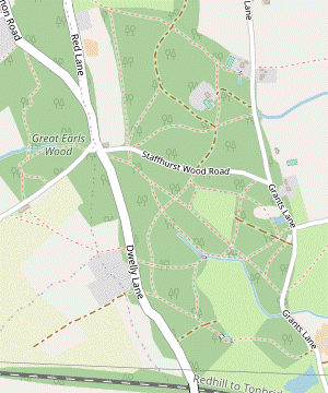 Take the footpath through the wood and across the side of an assart (clearing) into the south-western part of Staffhurst Wood. Follow a path through the wood to a pond at the northern corner of the assart, then turn left to head north-west to the junction of Dwelly Lane and Staffhurst Wood Road. Continue through Great Earls Wood to the Royal Oak pub on Caterfield Lane.
-
Follow the public footpath through the wood, curving left and downhill. At the bottom go over a stile and keep ahead across the southern side of a large assart (woodland clearing). On the far side ignore a gate at the end of the hedge on your left, but go over a stepped stile a little way off to the right into Staffhurst Wood? and follow the path round to the right.
There are many paths through this open-access wood. The suggested route starts off roughly parallel to Dwelly Lane (150m away to the left) and eventually meets it at a crossroads 800m ahead. If you are not sure of the route you can simply make your way across to this road and resume the directions at [?] when you reach this junction.
-
Assuming the path layout remains unchanged, fork right at a minor path junction and keep left at the next one, both in the first 100m. At a major junction ignore a long straight path off to the left (leading to Dwelly Lane). A little further on at a marker post with a yellow waymarker pointing left, fork right to leave the public footpath.
- The path heads N and gets closer to the right-hand edge of the wood. Unless a short length of boardwalk has been reinstated you will probably need to skirt around a boggy area at one point. The path then merges with a public footpath from the left and comes to the northern corner of the assart, where you cross the outlet from a pond on the left.
- After passing the pond veer left uphill onto a path heading NW, with a stream in the wooded valley down to your left. In 200m keep ahead at a path crossing, where a green arrow on a marker post shows that you are (briefly) joining a self-guided trail through the wood.
- In a further 200m fork left at another of these marker posts, leaving the trail (which is heading towards wooden barriers in front of Staffhurst Wood Road, 50m away). Follow a narrow path through undergrowth for 100m to emerge on Dwelly Lane at a crossroads, with the unusual St Silvan's House? on the far side of Staffhurst Wood Road.
- Take care crossing the next two roads as traffic from the right is faster than you might expect. Go across Dwelly Lane onto a short link road, then bear right across the second road (Caterfield Lane) towards a wooden fieldgate. Squeeze through a gap to its right to enter the Woodland Trust's Great Earls Wood.
-
Follow the woodland path for 200m as it heads W through a chestnut coppice, keeping ahead at a path crossing halfway along. At a path T-junction turn left and in 30m keep ahead at another path crossing by a small wooden bench. In 100m the path returns to Caterfield Lane opposite the main car park for the Royal Oak pub, the suggested lunch stop.
- The Royal Oak to Popes Lane (2¼ km)
- Take the footpath heading west past Sunt Farm and across the East Grinstead railway line to Foyle Farm. Continue on the footpath heading north-west, across the River Eden to Popes Lane.
- Turn left out of the pub and go down a short path at the back of its other car park to Caterfield Lane. Cross the road carefully and take the driveway just off to the left, which is also a public footpath. Follow this past a cluster of buildings, including the imposing Sunt Barn on your left.
- At the end of the buildings keep ahead across a field towards the East Grinstead railway line. Cross the tracks and continue in the same direction up the right-hand side of a large field, initially with a wood on your right and then a hedge as you descend. Go over a stile next to a fieldgate onto a junction of tracks in front of the buildings of Foyle Farm.
- Take the second track on the left, passing the farmhouse on your right. In front of a barn veer sharply right as indicated by a yellow waymarker, soon passing a pond on your left as the track curves round to the left. At a three-way footpath signpost turn right onto a farm track heading NW between fields, gently uphill.
- Continue in the same direction along the edge of the next field, now with a wood on your right. At the top of the rise go through a metal fieldgate (or over a pair of stiles in the tree boundary if necessary) and down a large field towards a hedge. Cross a plank bridge flanked by two stiles and carry on across a smaller field to an old footbridge taking you over the River Eden?.
- Continue along the right-hand side of another large farm field, still heading NW. In 300m (where the field boundary turns right) keep ahead across the field, slightly to the right. If there is no clear path aim to the right of a wide gap in the hedge on the far side; you will be leaving the field through another gap in the far corner, 300m away.
- After crossing the field continue with a hedge on your left to this corner. Go out past a vehicle barrier and continue in the same direction on a minor road (Popes Lane). In 75m there is a gap in the hedge on the left for a bridleway (unsignposted at the time of writing).
- Popes Lane to Southlands (2 km)
- Take the bridleway heading west off Popes Lane to Gibbs Brook Lane, then the footpath past Rose Farm and through Southlands Wood. Turn right briefly onto Southlands Lane, then head north up the long driveway to Southlands.
- For the full walk turn left off the lane onto this bridleway, heading W across a large field and aiming for the middle of a small wood. On the far side follow a short path through the trees to a lane (Gibbs Brook Lane) and turn right. In 75m turn left past a metal fieldgate into a large field and continue along its left-hand edge.
- As the field starts to slope downhill you can see an isolated house ahead; you will be skirting around it on the left. After crossing an old stile in a low hedge continue across some rough ground towards the house's garden. Go over a stile and follow a narrow enclosed path around it. At the end go straight across a track and over a stile to continue across another field, still heading W.
-
On the far side cross a plank bridge over a ditch into Southlands Wood. To stay on the right of way you should follow the path ahead, which soon bends right and in 250m comes out onto a road (Southlands Lane); you would then need to turn right and go along this fairly busy road with no pavement for 125m to reach the driveway to “Southlands” on the left.
- You can avoid this awkward stretch of road walking by turning right immediately after entering Southlands Wood; a faint path close to its right-hand edge eventually comes out directly opposite this driveway. This is not shown as a right of way but at the time of writing there was nothing to deter walkers from using this safer route.
- Either way, take this long driveway heading N off Southlands Lane, signposted as a footpath and climbing gently between fields and a wood. In 500m it swings right and left and goes past Southlands Cottage, with a much larger house “Southlands” off to the left.
- Southlands to Tandridge Church (1 • 1½ km)
- Go past the house and turn left at a T-junction with a bridleway, briefly joining the Greensand Way (GW). On the outskirts of Tandridge the most direct route is to stay on the bridleway as it curves right up a slope to Tandridge Lane, but you could also detour into the village to visit the Barley Mow. Turn right onto Tandridge Lane to come to the churchyard.
-
At the top of the track go over a stile beside a fieldgate and keep ahead across a field, still climbing. On the far side go over another stile onto a short path through trees and ferns to a T-junction and turn left onto a bridleway, briefly joining the Greensand Way? (GW).
The remainder of the walk is the same as Walk #2/2a.
- This potentially muddy track climbs gently at first and then goes steadily downhill, with occasional views across the Eden Valley through the trees on the left. At the bottom of the slope the path goes under a low bridge and continues between hedges, with a meadow on the left. In 150m there is a gate into the meadow which is the continuation of the GW.
-
Main route
- Stay on the bridleway, leaving the GW. The track curves right and climbs steadily, soon becoming a tarmac driveway. After going past a few buildings it curves left to come out onto a minor road (Tandridge Lane) at the top of the village. Turn right onto the road and cross another driveway to come to the tarmac path leading to the church.
-
Route via the Barley Mow (+500m)
- For the pub turn left through the gate and follow a grassy path sloping up to the right. At the brow of the hill keep right and go up to a metal kissing gate in the corner. Go through this onto a short sunken path through a belt of trees, which turns left and merges with a broad path from the right.
- You soon pass the beer garden of the Barley Mow on the right and the path swings round to its side entrance. After visiting the pub retrace your steps past its beer garden as far as the path junction where you came down from the right.
- Fork left at the Y-junction, staying on the main path and leaving the GW. Keep to the left of a driveway and follow the footpath gently uphill between houses and gardens. At the top turn right onto Tandridge Lane. Keep right at a minor road junction and continue across two driveways to come to the tarmac path leading to the church.
- Tandridge Church to Old Oxted (1¾ km)
- Cut through St Peter's churchyard to see the ancient Tandridge Yew. Return to Tandridge Lane and take a footpath on the right which leads up to and across a golf course. On the far side turn right onto a tarmac path above the A25 and continue on the old Godstone Road into Old Oxted.
- Go up the path and through the lychgate into the churchyard. As you approach St Peter's church? (which is usually locked) you pass the magnificent Tandridge Yew?.
- Turn left between this ancient tree and the church to rejoin Tandridge Lane, then almost immediately bear right onto a signposted footpath through a small copse. At the end of the trees, cross a driveway and go through a kissing gate into a field. Follow the grassy path uphill to another gate, which leads you onto a golf course.
- The path heads NE, slightly downhill through trees. At the end of the trees keep ahead across a fairway, aiming just to the left of a house. Take the tarmac drive which starts alongside the house and follow it all the way through the golf course, taking care as you cross more fairways near the end.
- After leaving the course and crossing its access road, turn right onto a tarmac path above the A25. The path descends and later curves away from the main road, following the course of the old Godstone Road. A slip road from the A25 joins from the left and you continue to a crossroads in the centre of Old Oxted, with the Old Bell opposite and two more pubs ahead if you want to break for refreshment.
- Old Oxted to Oxted Station (2 • 1 km)
-
 For the full walk, leave Old Oxted by heading south on Beadles Lane. Turn left into Springfield and take a footpath to the right of a driveway which curves round to the right. At the end turn left onto Spring Lane.
Go past Oxted Mill and take a footpath on the left across a meadow to Woodhurst Lane. Turn left along the road, then in 100m turn half-left onto an enclosed footpath. Go across the A25 and down East Hill Road to a roundabout. Turn right and go along Station Road West to the station.
For the full walk, leave Old Oxted by heading south on Beadles Lane. Turn left into Springfield and take a footpath to the right of a driveway which curves round to the right. At the end turn left onto Spring Lane.
Go past Oxted Mill and take a footpath on the left across a meadow to Woodhurst Lane. Turn left along the road, then in 100m turn half-left onto an enclosed footpath. Go across the A25 and down East Hill Road to a roundabout. Turn right and go along Station Road West to the station.
-
For a direct route to the station, go down Old Oxted's High Street and follow Church Lane to Station Road West.
-
For a direct route to the station, go down Old Oxted's High Street and follow Church Lane to Station Road West.
-
Main route (2 km)
- From the crossroads head S on Beadles Lane for 200m, then turn left into Springfield?. Where this street bends left keep ahead on a signposted footpath, briefly along a driveway and then a narrow fenced path to its right. This soon curves round to the right, later with a stream on the left. Follow the path past a mill pond to Spring Lane, with the converted Oxted Mill ahead on your left.
-
Go past Oxted Mill to the sluice-gate at the end of the mill pond and take the signposted footpath on the left, through a new wooden kissing gate into an overgrown meadow. Follow the grassy path heading NE, later with gardens and a stream off to the left. Cross the stream at a weir and go up a driveway to a road (Woodhurst Lane).
- Turn left and go along the road for 100m. At its junction with Woodhurst Park turn half-left onto a tarmac path between fences, which climbs steadily and in 200m comes out onto the A25. Cross this busy road with great care and go straight ahead down East Hill Road. Turn right at a roundabout into Station Road West.
-
Short cut (1 km)
- From the crossroads head E down the High Street, soon passing the George Inn and the Crown Inn. Just before the last house on the left turn left onto a tarmac path leading to an underpass.
- After going under the A25 follow the path to a road junction and turn left into Church Lane, signposted to the station and town centre. In 600m keep ahead at a roundabout into Station Road West.
-
The station is at the end of this road, 225m away. There are two possible tea places towards the end of the parade of shops on the right: Robertsons and Café Papillon. The Oxted Inn is on the right of the station entrance.
-
You could also take the pedestrian tunnel under the station and go through a small parking area into Station Road East: Caffè Nero is on the left; a Costa and several other refreshment places are down the road to the right.
-
You could also take the pedestrian tunnel under the station and go through a small parking area into Station Road East: Caffè Nero is on the left; a Costa and several other refreshment places are down the road to the right.
- Popes Lane to The Haycutter (1¾ km)
- Head north-west on Popes Lane to a T-junction and turn right onto Broadham Green Road. Follow this lane all the way to Broadham Green. At the end of the green turn right to go alongside Tanhouse Road, joining the Greensand Way (GW) and coming to The Haycutter.
- Continue along Popes Lane to a T-junction and turn right onto Broadham Green Road. In 100m you pass a footpath and the gates of Stockett's Manor on the right as the lane curves round to the left. In a further 100m there is another signposted footpath on the right.
- Ignore this footpath and stay on the lane for a further 750m, where it joins a busier road (Southlands Lane). Continue carefully in the same direction; in about 100m there is a path on a grassy strip on the right-hand side of the road, which later widens into the triangular Broadham Green.
- Stay near the right-hand side of the green. In the far corner bear right to go alongside Tanhouse Road on a broad grassy strip, joining the Greensand Way? (GW). In 150m you come to The Haycutter pub on the right, a possible refreshment stop.
- The Haycutter to Oxted Station (1¾ km)
-
Opposite the pub take a footpath heading north across fields to Spring Lane.
…
- Cross the road opposite the pub and go through a wooden kissing gate onto a grassy path heading roughly N across three fields, negotiating some potentially muddy areas around the gates between them. At the end of the last field go through another gate and continue between a house and outbuildings to come out onto Spring Lane, with the converted Oxted Mill on the right.
- …
- …
- …
- Popes Lane to Hurst Green Station (2 km)
- … In 200m take the second footpath on the right, across a large field. Cross the River Eden and keep left on a path leading to Mill Lane Playing Field. Skirt around a running track to reach Mill Lane and make your way across the village green to the station.
- …
- Turn right off the road onto this second footpath, with a very old notice stating that you are trespassing if you do not follow the right of way going straight across a large field to its far left-hand corner. However, after going over a stile into the field you will almost certainly discover that there is no such path on the ground; it seems clear that everyone walks around the perimeter, with the path around the right-hand edge being marginally shorter.
- Having made your way to the exit in the far corner, cross the River Eden on a footbridge and keep left on a fenced path, ignoring one on the right leading to Coltsford Mill (an up-market wedding venue). In 200m you cross a stream leading to the mill pond and emerge into a large playing field. Bear left onto a path around its perimeter, skirting a running track.
- After the path has curved right stay near the field edge, passing to the left of some tennis courts. In the field corner go out past a vehicle barrier and turn left briefly onto Mill Lane. At the end of a hedge veer right onto a signposted footpath across a large village green.
- In the middle of the green you cross Hurst Green Road and continue to the far corner, passing St Agatha's Hall off to the left on Greenhurst Lane. Bear right onto this road, go past a side street and fork left down the station approach road. If the ticket office is closed, the entrance to Platform 1 (for trains to London) is at the left-hand end of the building.
- Lagham Manor had the largest non-military moat in south-east England. The settlement here changed its name from Lagham to South Godstone when the railway was built.
- St George, Crowhurst dates from the 12thC, with later additions and rebuilding. This small parish church is unusual in that it largely escaped the attentions of the 19thC restorers.
- The Crowhurst Yew is a male tree with a girth of 10 metres. In 1820 it was hollowed out and a cannon ball dating from the Civil War found inside it, partially overgrown with new wood. Coincidentally there is another ancient yew tree in a Sussex village called Crowhurst, a source of confusion in the historical records.
- The source of the River Eden is in the Titsey estate, 2 km north-east of Oxted on the slopes of the North Downs. A Saxon named Eadhelm built a bridge over the river and the town “Eadhelmsbrigge” (later Edenbridge) gave its name to the river. It flows into the River Medway near Penshurst.
- Staffhurst Wood is a Local Nature Reserve and Site of Special Scientific Interest managed by the Surrey Wildlife Trust as a traditional ‘coppice with standards’ wood. It has a fine display of bluebells in spring and many varieties of fungi in autumn.
- St Silvan's House was built in 1898 as a Mission Room and was licensed as a church from 1930-2013, before being converted into a residential dwelling.
- The Greensand Way runs for 175 km from Haslemere in Surrey to Hamstreet in Kent, following the course of a sandstone ridge just to the south of the North Downs.
- St Peter, Tandridge dates from the early 12thC. It was restored by Sir George Gilbert Scott in the 19thC; there is a marble tomb-monument in the churchyard to his wife (Lady Scott) who died in 1872. The church contains a reproduction of the famous Ghent Altarpiece by the van Eyck brothers.
- The Tandridge Yew is a female tree which still produces berries. It is exceptionally tall and has a girth of 11 metres. Judging by its measured rate of growth it is at least 1,000 years old; some sources speculate that it is much older.
- The Springfield housing development is on the site of Oxted's Old School, as shown by the “Oxtead National Schools 1872” inscription preserved on the stone wall.
If you want to cut out the loop through Tandridge, go to §K for a more direct route to Oxted or §M to finish at Hurst Green.
If you want to visit the Barley Mow, follow the directions in [?].
The main route to the station loops past Oxted Mill on Spring Lane, but if you are in a hurry you could take the short cut along roads in [?].
The final part of the walk is the same as the ‘alternative afternoon’ route of Walk #2.
Walk Notes
» Last updated: June 21, 2024
Return to Top | Walk Map | Walk Options | Walk Directions.