Haddenham Circular via Brill walk
Strenuous walk linking several hill top villages in the rolling landscape of the north westerly Aylesbury Vale, with splendid views throughout.

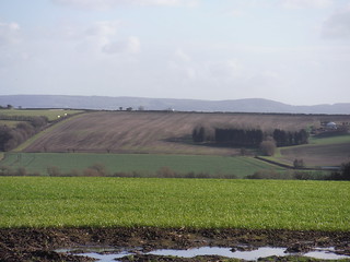
View from Chilton House
SWC Walk 191a Haddenham Circular (w/o Brill)
Jan-16 • thomasgrabow on Flickr
swcwalks swcwalk191 walkicon banner 24111581353

Close-Up of Tree in Valley NE of Long Crendon, on way to Wombwell's Farm
SWC Walk 191 Haddenham Circular (via Brill)
Jan-16 • thomasgrabow on Flickr
walkicon swcwalks swcwalk191 24110319024

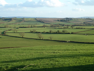
Towards the Pollicotts and Ashendon
SWC Walk 191a Haddenham Circular (w/o Brill)
Jan-16 • thomasgrabow on Flickr
walkicon swcwalks swcwalk191 24644861721
Aylesbury Astrological Society's Observatory and Chilterns beyond, from Upper Pollicott
SWC Walk 191a Haddenham Circular (w/o Brill)
Jan-16 • thomasgrabow on Flickr
walkicon swcwalks swcwalk191 24738313435
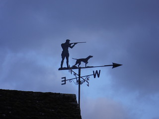
Weather Vane, Haddenham
SWC Walk 191 Haddenham Circular (via Brill)
Jan-16 • thomasgrabow on Flickr
walkicon swcwalks swcwalk191 24370442389
| Length |
27.7 km (17.2 mi), with 412m ascent/descent. For a shorter walk see below Walk Options. |
|---|---|
| Toughness |
7 out of 10, with 6 hours 20 minutes walking time. For the whole outing allow at least 8 hours 45 minutes. |
| Walk Notes |
This is a very rewarding walk through the pleasant rolling countryside of the north westerly parts of Aylesbury Vale, just north of the Chilterns, with some far views on clear days.
The walk first crosses the Thame Valley north of Haddenham and then passes through the area of the ancient Bernwood Royal Hunting Forest on a wide circular route to return south on a different route back through the Thame Valley to Haddenham.
The walk contains several arable field crossings as well as plenty of pastures, hayfields and meadows, some of which will feature high grass in summer. |
| Walk Options |
A Shortcut half-way through the morning cuts the charming hilltop village of Brill (cut 7.6 km (4.7 mi) and 156m descent/re-ascent). This route is rated 4/10.
|
| Maps |
OS Explorer Map: 180 (Oxford) & 181 (Chiltern Hills North).
|
| Travel |
Haddenham & Thame Parkway station, map reference SP 731 085, is 10 km south west of Aylesbury, 22 km east of Oxford, and 81m above sea level. Haddenham is in Buckinghamshire. The station is on the London Marylebone to Bicester main line, served by trains to Oxford or Banbury. Journey times are from 37 minutes. Saturday Walkers’ Club: Take the train closest to 9.30 hours. |
| Lunch |
The Pointer 27 Church Street, Brill, Buckinghamshire, HP18 9RT (01844 238 339). The Pointer is located 12.1 km (7.5 mi) into the walk.
|
| Tea |
The Crown at Cuddington Aylesbury Road, Cuddington, Buckinghamshire, HP18 0BB (01844 292 222). The Crown is located 3.7 km from the end of the walk.
|
| Profile | |
|---|---|
| Help Us! |
After the walk, please leave a comment, it really helps. Thanks! You can also upload photos to the SWC Group on Flickr (upload your photos) and videos to Youtube. This walk's tags are: |
| By Train |
Out (not a train station) Back (not a train station) |
| By Car |
Start HP17 8EQ Map Directions |
| Amazon | |
| Help |
National Rail: 03457 48 49 50 • Traveline (bus times): 0871 200 22 33 (12p/min) • TFL (London) : 0343 222 1234 |
| Version |
Apr-24 Thomas G |
| Copyright | © Saturday Walkers Club. All Rights Reserved. No commercial use. No copying. No derivatives. Free with attribution for one time non-commercial use only. www.walkingclub.org.uk/site/license.shtml |

Walk Directions
Full directions for this walk are in a PDF file (link above) which you can print, or download on to a Kindle, tablet, or smartphone.
This is just the introduction. This walk's detailed directions are in a PDF available from wwww.walkingclub.org.uk