Haslemere Outer Orbital Path Walk
Orbital route around Haslemere from a rural bus stop, but with plenty of options for connecting routes from the station

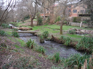
Cooper's Stream/Waggoner's Wells Ponds
SWC 377 - Haslemere Outer Orbital Path
Nov-22 • thomasgrabow on Flickr
swcwalks swcwalk377 banner 52506518436
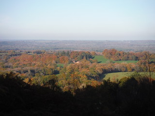
View from Temple of the Four Winds into the Plain
SWC 377 - Haslemere Outer Orbital Path
Nov-22 • thomasgrabow on Flickr
swcwalks swcwalk377 banner 52506991035
Wey River (south branch), Hammer Bottom
SWC 377 - Haslemere Outer Orbital Path
Feb-21 • thomasgrabow on Flickr
swcwalks swcwalk377 walkicon 51046567867
![Sailor's Memorial Stone, Devil's Punch Bowl SWC 377 - Haslemere Outer Orbital Path [Gibbet Hill Alternative]](https://live.staticflickr.com/65535/51046477586_438a5abc57_n.jpg)
Sailor's Memorial Stone, Devil's Punch Bowl
SWC 377 - Haslemere Outer Orbital Path [Gibbet Hill Alternative]
Feb-21 • thomasgrabow on Flickr
swcwalks swcwalk377 walkicon 51046477586

Mire on Black Down
SWC 377 - Haslemere Outer Orbital Path
Feb-21 • thomasgrabow on Flickr
swcwalks swcwalk377 walkicon 51046562942
| Length |
26.8 km (16.6 mi), with 623m ascent/descent. For a shorter or longer walk see below Walk Options. |
|---|---|
| Toughness |
8 out of 10, with 6 ½ hours walking time. For the whole outing, including trains, sights and meals, allow at least 10 hours. |
| Walk Notes |
This is an interesting circular route orbiting around Haslemere, covering plenty of areas and sights familiar from other SWC walks, but also lots of new ground, for example Bramshott Common, the Waggoner’s Wells ponds, Whitmore Vale, Grayswood, Ansteadbrook and the woods west of Black Down. The Haslemere Outer Orbital Path (HOOP) was originally conceived by Neil Hook and is featured – with written directions – on his website. The route starts at a bus stop in Kingsley Green served by an hourly service (Mon-Sat), 3 km outside of Haslemere, but additional start or finish points can usefully be accessed either by other bus lines or on foot, along spoke routes from Haslemere Station, using some of the existing SWC walks. For details see below. Fully written directions for the spoke routes are available in the walk directions pdf linked above. |
| Walk Options | Bus Lines linking to the HOOP
Spokes and Bus Stops throughout the route
Spoke routes and bus stops are shown on the route map linked above. |
| Maps |
OS Explorer: OL33 (Haslemere & Petersfield)
|
| Travel |
Kiln Meadow Bus Stop in Kingsley Green, map reference SU 895 307, is 64 km southwest of Charing Cross, 154m above sea level and in West Sussex. It is served by bus line 70 Guildford – Midhurst (via Haslemere Station), with an hourly service Mon-Sat. Return Fare from Haslemere (12/20): £5.00. Haslemere station is on the Portsmouth Direct Line from London Waterloo to Portsmouth Harbour, with up to four trains an hour Mon-Sat (two on Sundays). Journey time is from 48 minutes Mon-Sat (56 minutes on Sundays). Saturday Walkers’ Club: Take a train no later than 09.30. |
| Lunch |
The Prince of Wales, Hammer Vale, 4.6 km into the route;
|
| Tea |
Harper’s Steakhouse & Bar, opposite Haslemere Station. |
| Profile | |
|---|---|
| Help Us! |
After the walk, please leave a comment, it really helps. Thanks! You can also upload photos to the SWC Group on Flickr (upload your photos) and videos to Youtube. This walk's tags are: |
| By Train |
Out (not a train station) Back (not a train station) |
| By Car |
Start Map Directions |
| Amazon | |
| Help |
National Rail: 03457 48 49 50 • Traveline (bus times): 0871 200 22 33 (12p/min) • TFL (London) : 0343 222 1234 |
| Version |
Aug-24 Thomas G |
| Copyright | © Saturday Walkers Club. All Rights Reserved. No commercial use. No copying. No derivatives. Free with attribution for one time non-commercial use only. www.walkingclub.org.uk/site/license.shtml |

Walk Directions
Full directions for this walk are in a PDF file (link above) which you can print, or download on to a Kindle, tablet, or smartphone.
This is just the introduction. This walk's detailed directions are in a PDF available from wwww.walkingclub.org.uk