Haslemere to Farnham walk
A wooded ridge, Temple of the Four Winds, Gibbet Hill, Devil's Punch Bowl, Highcomb Bottom, Thursley & Hankley Commons, Atlantic Wall, River Wey, Waverley Abbey's ruins

Boardwalk in Pudmore Pond Area, Thursley Common
SWC Walk 144 Haslemere to Farnham - Thursley Common Extension (Pudmore Pond Extension-within-the-Extension)
Feb-17 • thomasgrabow on Flickr
swcwalks swcwalk144 banner 32319666763
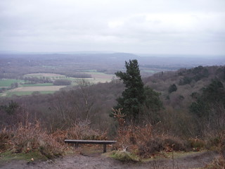
Gibbet Hill, Northerly Views
SWC Walk 144 Haslemere to Farnham
Feb-17 • thomasgrabow on Flickr
swcwalks swcwalk144 walkicon 33135516665

Devil's Punch Bowl and old course of the A3
SWC Walk 144 Haslemere to Farnham
Feb-17 • thomasgrabow on Flickr
swcwalks swcwalk144 walkicon 32752887100
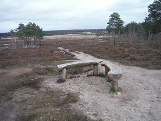
Angled Bench at Viewpoint on Shrike Hill, Thursley Common
SWC Walk 144 Haslemere to Farnham - Thursley Common Extension
Feb-17 • thomasgrabow on Flickr
swcwalks swcwalk144 walkicon 32752670180

Breach in The Atlantic Wall, Hankley Common
SWC Walk 144 Haslemere to Farnham - Atlantic Wall Extension
Feb-17 • thomasgrabow on Flickr
swcwalks swcwalk144 walkicon 32752495250
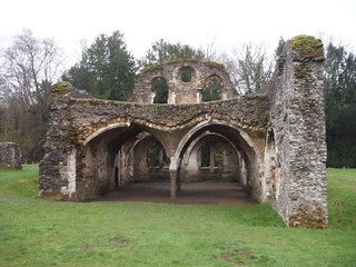
Part of Waverley Abbey Ruin
SWC Walk 144 Haslemere to Farnham - Waverley Abbey Extension
Feb-17 • thomasgrabow on Flickr
swcwalks swcwalk144 walkicon 33093134776

Tree in Coombswell Copse
SWC Walk 144 Haslemere to Farnham
Feb-17 • thomasgrabow on Flickr
swcwalks swcwalk144 32978777822
| Length | 23.6 km (14.7 mi), with 433/496m ascent/descent. For a different route up to Gibbet Hill, and options to shorten or to lengthen, see below Walk Options. |
|---|---|
| Toughness | 6 out of 10, with 5 hours 15 minutes walking time. For the whole outing, including trains, sights and meals, allow at least 8 ½ hours. |
| Walk Notes |
The route leads out of Haslemere in a northerly direction along the quietest and shortest possible route to ascend through Coombswell Copse and along the wooded Invall ridge up to Hurt Hill and the Temple of the Four Winds, the ruin of an early 20th century belvedere, and one of several viewpoints with striking vistas. Turn westerly up to Gibbet Hill (the second highest point in Surrey), with more far reaching views, out to the North Downs and London, as well as back to Black Down and to the South Downs.
Note: Before embarking on this walk, please read below section on Managed Access on Hankley Common. |
| Walk Options |
An alternative ascent route to Gibbet Hill via Hindhead Common (with an option for a diversion via the Devil’s Punchbowl Café or Hotel for Elevenses) cuts 450m and 104m ascent/descent. To shorten the walk:
To lengthen the walk:
A Haslemere Circular Walk is possible by following the main walk to Thursley for lunch (or just to Gibbet Hill) and reverse-walking (map-led) the alternative start via Hindhead Common (for a tea stop include the diversion to the Punchbowl Café), or vice versa. |
| Managed Access on Hankley Common |
The current status of access rights on the MOD land of Hankley Common should be checked at https://www.gov.uk/guidance/public-access-to-military-areas#contents [under ‘Locations in South East England – Hankley and Elstead Commons’]. At time of writing the relevant rules are as follows:
|
| Maps | OS Explorer: OL33 (was 133) Haslemere & Petersfield
Landranger 186: Aldershot & Guildford |
| Travel | Haslemere Station, map reference SU 897 329, is 62 km south west of Charing Cross, 139m above sea level. Farnham Station, map reference SU 844 465, is 15 km north north west of Haslemere and 76m above sea level. Both towns are in Surrey. It is on the Portsmouth Direct Line from London Waterloo to Portsmouth Harbour, with up to four trains an hour Mon-Sat (two on Sundays). Journey time is from 48 minutes Mon-Sat (56 minutes on Sundays). Farnham is a stop on the Alton line from Woking via Aldershot, with a half-hourly service (journey time from 53 mins Mon-Sat and from 59 mins Sun, both if changing at Woking). Buy a Haslemere return, you then may have to buy a separate Farnham to Woking single.
Saturday Walkers’ Club: Take the train closest to 9.00 hours. |
| Elevenses/Lunch |
The Devil’s Punch Bowl Café (01428 681 050). The Devil’s Punchbowl Café is located 4.5 km (2.8 mi) into the walk, if following the alternative ascent route.
|
| Tea |
The Barley Mow (as above).
|
| Profile | |
|---|---|
| Help Us! |
After the walk, please leave a comment, it really helps. Thanks! You can also upload photos to the SWC Group on Flickr (upload your photos) and videos to Youtube. This walk's tags are: |
| By Train |
Out (not a train station) Back (not a train station) |
| By Car |
Start GU27 2PD Map Directions Return to the start: Finish GU9 8AD Map Directions Travel to the start: |
| Amazon | |
| Help |
National Rail: 03457 48 49 50 • Traveline (bus times): 0871 200 22 33 (12p/min) • TFL (London) : 0343 222 1234 |
| Version | |
| Copyright | © Saturday Walkers Club. All Rights Reserved. No commercial use. No copying. No derivatives. Free with attribution for one time non-commercial use only. www.walkingclub.org.uk/site/license.shtml |


Walk Directions
Full directions for this walk are in a PDF file (link above) which you can print, or download on to a Kindle, tablet, or smartphone.
This is just the introduction. This walk's detailed directions are in a PDF available from wwww.walkingclub.org.uk