Hathersage Circular via Stanage Edge Higger Tor and Padley Gorge walk
Dark Peak Highlights - up a green valley to Stanage Edge, over Higger Tor and Carl Wark hill forts and down the narrow wooded Padley Gorge, then along the Derwent River

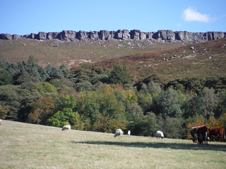
Backview to Eyam Moor from near North Lees Hall
SWC Walk 319 - Hathersage Circular (via Stanage Edge, Higger Tor & Padley Gorge)
Aug-18 • thomasgrabow on Flickr
swcwalks swcwalk319 walkicon 31222151258

Along Stanage Edge
SWC Walk 319 - Hathersage Circular (via Stanage Edge, Higger Tor & Padley Gorge)
Aug-18 • thomasgrabow on Flickr
swcwalks swcwalk319 walkicon 43281936550
Stanage Edge from North Lees Hall
SWC Walk 319 - Hathersage Circular (via Stanage Edge, Higger Tor & Padley Gorge)
Sep-18 • thomasgrabow on Flickr
swcwalks swcwalk319 walkicon 45046929542

Higger Tor and Carl Wark from Longshaw Estate
SWC Walk 319 - Hathersage Circular (via Stanage Edge, Higger Tor & Padley Gorge)
Sep-18 • thomasgrabow on Flickr
swcwalks swcwalk319 walkicon 44184472035

Padley Gorge
SWC Walk 319 - Hathersage Circular (via Stanage Edge, Higger Tor & Padley Gorge)
Sep-18 • thomasgrabow on Flickr
swcwalks swcwalk319 walkicon 45046887902

Millstone Edge
SWC Walk 319 - Hathersage Circular (via Stanage Edge, Higger Tor & Padley Gorge)
Sep-18 • thomasgrabow on Flickr
swcwalks swcwalk319 walkicon 43281949940
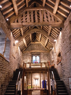
Padley Chapel
SWC Walk 319 - Hathersage Circular (via Stanage Edge, Higger Tor & Padley Gorge)
Aug-18 • thomasgrabow on Flickr
swcwalks swcwalk319 31222149298
| Length |
20.0 km (12.4 mi), with 488m ascent/descent. For a shorter walk, see below Walk Options. |
|---|---|
| Toughness |
6 out of 10, with 5 hours 30 minutes walking time. For the whole outing, including trains, sights and meals, allow at least 12 hours. |
| Walk Notes |
Centred on Hathersage, an attractive village in the Hope Valley, this route leads through some outstandingly beautiful scenery and passes along the cliffs of the Stanage Edge as well as over the distictive Higger Tor and the ancient iron-age hill fort of Carl Wark on Burbage Moor and down the spectacular wooded Padley Gorge.
|
| Walk Options |
A Variation near the start follows the Hood Brook through attractive woods rather than going past North Lees Hall (certainly recommended in bluebell season).
|
| Maps |
OS Explorer: OL1 (The Peak District – Dark Peak Area)
|
| Travel |
Hathersage station, map reference SK 232 810, is 14 km south west of Sheffield, 227 km north west of Charing Cross, 163m above sea level and in Derbyshire. It is on the Hope Valley Line from Manchester to Sheffield, with a journey time of 18 mins from Sheffield. Sheffield Station is the terminus of the Midland Main Line from London St. Pancras, with two trains per hour (journey time from 116 mins Mon-Sat, longer on Sundays). Saturday Walkers Club: Take a train no later than 9.00 hours. |
| Lunch |
The Fox House Inn Hathersage Road, Longshaw, Sheffield, South Yorks, S11 7TY (01433 630 374). The Fox House is located 10.8 km (6.7 mi) into the walk and the pub lunch stop.
|
| Tea |
Plenty of options, both on or just off route as well as off route on a loop through Hathersage at the end. Check the pdf for details. |
| Profile | |
|---|---|
| Help Us! |
After the walk, please leave a comment, it really helps. Thanks! You can also upload photos to the SWC Group on Flickr (upload your photos) and videos to Youtube. This walk's tags are: |
| By Train |
Out (not a train station) Back (not a train station) |
| By Car |
Start S32 1DT Map Directions |
| Amazon | |
| Help |
National Rail: 03457 48 49 50 • Traveline (bus times): 0871 200 22 33 (12p/min) • TFL (London) : 0343 222 1234 |
| Version |
Apr-24 Thomas G |
| Copyright | © Saturday Walkers Club. All Rights Reserved. No commercial use. No copying. No derivatives. Free with attribution for one time non-commercial use only. www.walkingclub.org.uk/site/license.shtml |

Walk Directions
Full directions for this walk are in a PDF file (link above) which you can print, or download on to a Kindle, tablet, or smartphone.
This is just the introduction. This walk's detailed directions are in a PDF available from wwww.walkingclub.org.uk