Hathersage to Bamford (via Bamford and Hordron Edges) walk
Upper Derwent Valley walk out to Ladybower: griststone edges, moors with pre-historic features, overlooked by Stanage Edge, valleys and pastures with views

Ashopton Viaduct on Ladybower Reservoir, with Crook Hill
SWC Walk 360 - Hathersage to Bamford (via Bamford and Hordron Edges
Mar-20 • thomasgrabow on Flickr
banner swcwalks swcwalk360 49730863831
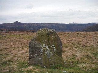
Hordron Edge Stone Circle: 'Fairy Stone' with Win Hill and Lose Hill
SWC Walk 360 - Hathersage to Bamford (via Bamford and Hordron Edges
Mar-20 • thomasgrabow on Flickr
swcwalks swcwalk360 banner 49730859386
From Outlane Farm to Stanage Plantation and Edge
SWC Walk 360 - Hathersage to Bamford (via Bamford and Hordron Edges
Mar-20 • thomasgrabow on Flickr
swcwalks swcwalk360 walkicon 49730868931

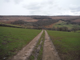
Ancient Oak Wood on Descent to Ladybower
SWC Walk 360 - Hathersage to Bamford (via Bamford and Hordron Edges
Mar-20 • thomasgrabow on Flickr
swcwalks swcwalk360 walkicon 49730865386
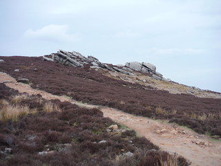
Hurkling Stones
SWC Walk 360 - Hathersage to Bamford (via Bamford and Hordron Edges
Mar-20 • thomasgrabow on Flickr
swcwalks swcwalk360 walkicon 49731183082

Sheep and the Wheel Stones (Derwent Edge)
SWC Walk 360 - Hathersage to Bamford (via Bamford and Hordron Edges
Mar-20 • thomasgrabow on Flickr
swcwalks swcwalk360 walkicon 49730313883

Win Hill beyond track on Moscar Moor
SWC Walk 360 - Hathersage to Bamford (via Bamford and Hordron Edges
Mar-20 • thomasgrabow on Flickr
swcwalks swcwalk360 walkicon 49730860226
| Length |
25.0 km (15.5 mi), with 862/869m ascent/descent. For a shorter walk see below Walk Options. |
|---|---|
| Toughness |
8 out of 10, with 6 hours 30 minutes walking time. For the whole outing, including trains, sights and meals, allow at least 13 hours. |
| Walk Notes |
Starting in Hathersage, an attractive village in the Hope Valley, this route leads up a quiet green valley towards the cliffs of the Stanage Edge, only to fork off along the Hood Brook through attractive woods (bluebells in season) and to rise further in a westerly direction through pastures-with-views and along the flanks of Bole Hill up to Bamford Moor and along its gritstone edge. Panoramic views of Mam Tor, Win Hill and Ladybower Reservoir keep the interest before a steep descent through an ancient oak wood and a newer plantation wood to the reservoir shore and the Ladybower Inn for lunch.
A post-lunch shortcut is described as well as an alternative afternoon route across Moscar and Bamford Moors past an array of pre-historic features (but do not walk this in Ground Nesting Season, from 1 March to 31 July). Note: For the protection of moorland birds, dogs are not permitted on Moscar and Bamford Moors at any time. In all other Access Land they have to be kept on short leads in Ground Nesting Season (01 March to 31 July). |
| Walk Options |
Shortcut after lunch: from the Ladybower Inn avoid the ascent up Lead Hill and on to Derwent Edge. Cut 4.9 km/3.0 mi and some ascent.
|
| Maps |
OS Explorer: OL1 (The Peak District – Dark Peak Area)
|
| Travel |
Hathersage station, map reference SK 232 810, is 14 km south west of Sheffield, 227 km north west of Charing Cross and 157m above sea level. Bamford station, map reference SK 207 825, is 3 km north west of Hathersage and 150m above sea level. Both are in Derbyshire. They are on the Hope Valley Line from Manchester to Sheffield, with a journey time of 18 mins to Hathersage and up to 24 mins from Bamford from/to Sheffield. Sheffield Station is the terminus of the Midland Main Line from London St. Pancras, with up to two trains per hour (journey time from 118 mins Mon-Sat, longer on Sundays). Saturday Walkers’ Club: Take a train no later than 9.00 hours. |
| Lunch |
The Ladybower Inn Bamford, Hope Valley, Derbyshire, S33 0AX (01433 651 241). The Ladybower Inn is located 10.2 km/6.3 mi into the walk and a quaint stone pub with rooms (some offering views of the picturesque Ladybower Reservoir). Owned by the Batemans Brewery from Lincolnshire. |
| Tea |
The Anglers Rest Main Road, Bamford, Derbyshire, S33 0DY (01433 659 317). The Anglers Rest is located 1.6 km from the end of the walk. In 2013 it became the first community pub in Derbyshire when it was purchased collectively by over 300 people. As a LocAle pub, they mainly source beers from the local area and have been awarded the Sheffield and District CAMRA pub of the month award for their selection of quality ales. |
| Profile | |
|---|---|
| Help Us! |
After the walk, please leave a comment, it really helps. Thanks! You can also upload photos to the SWC Group on Flickr (upload your photos) and videos to Youtube. This walk's tags are: |
| By Train |
Out (not a train station) Back (not a train station) |
| By Car |
Start S32 1DT Map Directions Return to the start: Finish S33 0AH Map Directions Travel to the start: |
| Amazon | |
| Help |
National Rail: 03457 48 49 50 • Traveline (bus times): 0871 200 22 33 (12p/min) • TFL (London) : 0343 222 1234 |
| Version |
Apr-24 Thomas G |
| Copyright | © Saturday Walkers Club. All Rights Reserved. No commercial use. No copying. No derivatives. Free with attribution for one time non-commercial use only. www.walkingclub.org.uk/site/license.shtml |

Walk Directions
Full directions for this walk are in a PDF file (link above) which you can print, or download on to a Kindle, tablet, or smartphone.
This is just the introduction. This walk's detailed directions are in a PDF available from wwww.walkingclub.org.uk