Henley Circular via Great Wood walk
The Thames Path in the morning, historic Hambledon for lunch, and back via the hills above Henley in the afternoon. Short but pretty.

Hambleden Lock
Henley Circular walk
Oct-10 • Saturdaywalker on Flickr
swcwalks book1 walk1 walkicon 27479500632
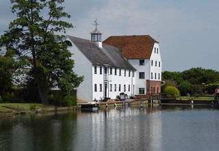
Hambleden Mill
Henley Circular walk
Jun-16 • Saturdaywalker on Flickr
swcwalks book1 walk1 walkicon 26969692663
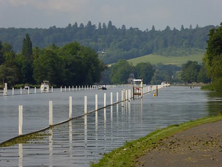
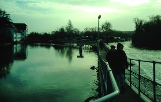
The Thames, laid out for the regatta
Henley Circular walk
Jun-16 • Saturdaywalker on Flickr
swcwalks book1 walk1 walkicon 27544078676

Henley-on-Thames (round walk)
The weir at Hambledon Lock. D.Allen vivitar 5199mp
Apr-06 • magyardave2002 on Flickr
thames lock book1 weir hambledon walk1 swcwalks 13114719714
Book 1 Walk 1 Henley-on-Thames (round)
Weir are we? Hambledon Lock. D.Allen Vivitar 5199mp
Jan-08 • magyardave2002 on Flickr
thames lock book1 weir hambledon walk1 swcwalks 2172853545
Temple Island, Hambleden & the Great Wood
| Length | 16.46km (10.23 miles), 4 hours 30 minutes. For the whole outing, including trains, sights and meals, allow 7 hours 50 minutes. |
|---|---|
| Toughness | 3 out of 10 (flat in the morning, some inclines after lunch). |
| OS Maps | Explorer 171 or Landranger 175. Henley-on-Thames, map reference SU 764 823, is in Oxfordshire, 10km north-east of Reading. |
| Features |
This is a very pretty walk, out along the Thames, and back via the hills above. Its mainly flat morning follows the Thames path to the quaint and well preserved hamlet of Hambleden with its brick and flint red roofed buildings. The return is via the wooded geological terrace above river. Historic riverside Henley, with many tea rooms and pubs, is a nice place to finish The walk starts in Henley (famous for its rowing regatta in late June or early July) and goes along the Thames towpath, with rowing instructors on bikes shouting instructions to their crews, past Temple Island with its neo-folly, to the 250-metre footbridge over the weir at Hambleden Mill, where canoeists practise in the stormy waters. Route finding is easy! From there the route is northwards to the suggested lunchtime pub in the well-preserved hamlet of Hambleden, which has a huge church out of all proportion to the population. After lunch, the walk for the next 2.5km takes you through the Great Wood, the endlessness of which gives an inkling of how most of Britain must once have been. From the village of Fawley with its church and mausoleum, the walk returns along the Oxfordshire Way, past the manor of Henley Park, to Henley for tea. |
| Walk Options |
You could get a bus back to Henley from Mill End (there are about three buses each hour) or a taxi from the pub in Hambleden. After completing the main Circular walk, in either direction, you can extend the walk by some 3.5km by continuing along the River Thames path to Shiplake. This pleasant extension comes out at Shiplake Railway station, where trains to Twyford are 4 minutes after leaving Henley. Reverse walk (clockwise) In winter you might like to try doing this walk "backwards" - that is, in reverse - or clockwise. The advantage of walking the longer leg of the walk through Great Wood first, means the shorter post lunch leg of 1.5 hrs on the level beside the River Thames is relatively safe and easy to walk in failing light or even darkness. Directions for walking the walk clockwise are given after the Main (anti-clockwise) Directions. |
| History |
Henley, with its 300 listed buildings, is said to be the oldest settlement in Oxfordshire; a Roman grain store and skeletons of 97 supposedly unwanted children were excavated at Mill End in 1911. Fawley Temple, the neoclassical folly on Temple Island, is maintained by the Henley Regatta on a 999-year lease. It was built by James Wyatt in 1771 for a local landowner, Sambrooke Freeman, and has Etruscan-style murals inside. Hambleden Mill, mentioned in the Domesday Book, was used for grinding corn until 1955. Hambleden means 'village in a valley'. Charles I spent one night at the manor house in Hambleden whilst fleeing from Oxford to St Albans in 1646. Its well preserved buildings are brick and flint, with red tiled roofs St Mary the Virgin Church, Hambleden, has a memorial with alabaster figures representing Sir Cope D'Oyley (who died in 1633), his wife and their ten children - with the children shown carrying skulls if they died before their parents. To the left of the monument is the oak muniment chest used by the Earl of Cardigan in Balaclava, where he led the ill-fated Charge of the Light Brigade in 1854. And to the left of this chest, tucked in an alcove, is a reusable stone coffin. The churchyard contains the grave of the bookseller WH Smith, who became (posthumously) Lord Hambleden. The village of Fawley from the Old English for 'clearing') is listed in the Domesday Book as having 13 villeins, one cottager and five slaves. In 1086 it was given to a Norman, Herbrand de Sackville, as a reward for guarding his master's estates in Normandy during the invasion of England. The churchyard in Fawley contains a large circular neoclassical mausoleum built by John Freeman for his family around 1750. |
| Travel |
Take the train nearest to 10 am (clockwise walk: 9.30 am) from Paddington station to Henley-on-Thames, changing at Twyford. Journey time 65 minutes. At Twyford you have to cross over a footbridge to the other platform. Be quick if the London train is late: although Great Western hold the Henley service for a few minutes for the London connection, there is an hour's wait if you miss the connection. For this reason, consider catching an earlier train than the timetable recommends. Trains back from Henley are hourly. Rail ticket: Now that Elizabeth Line trains are running between Paddington and Reading, if you are one of our senior walkers who holds a London Council's Freedom Pass you can travel free of charge on Elizabeth Line trains (blue livery) as far as Twyford, leaving you to purchase a day return from Twyford to Henley-on-Thames. However, if you travel on a Great Western train (green livery) from Paddington you will need an off-peak day return from the edge of your travel card (Zone 6) to Henley-on-Thames. By car: Henley Station has a car park (£4.50), or there is free parking a little way outside the town. |
| Lunch |
The suggested lunch pub is the Stag & Huntsman (01491 571 227), in Hambleden, an 18th century Grade 1 listed former coaching inn, some 6.1 km into the walk (10 km when doing the walk "backwards") which is open for breakfast, and lunch with a local and seasonal emphasis. Lunch times (2022) are 12 noon until 3 pm, Monday to Friday (with last orders taken at 2.30 pm) and 12 noon until 5 pm at weekends and on Bank Holidays. Booking ahead, or at least 'phoning ahead with numbers from Henley, is always advised, and is essential on Sundays and on Bank Holidays, such as New Year's Day. |
| Tea |
There are a number of tea options, restaurants and pubs in Henley to suit most tastes. The Chocolate Cafe (01491 411412) on Thames Side, facing the river, is open until 5.30 pm on weekdays and 6 pm at weekends. In summer the church of St Mary the Virgin on Hart Street (the high street) serves tea with homemade cakes on Sunday afternoons. Pubs include The Angel on the Bridge on the river, and a Wetherspoons on Hart Street If extending your walk to Shiplake, your walk-end refreshment stop is the pub next to the railway station - the Baskerville Arms . |
| Updates |
No major changes. Minor updates - and addition of Clockwise Directions - provided October 2019. This latest book check and walk update January 2022. Walk length aligned with GPS January 2024. |
| Book |
This walk was originally published in Time Out Country Walks near London volume 1. We now recommend using this online version as the book is dated. The book contained 53 walks, 1 for every week of the year and 1 to spare. Here is our suggested schedule |
|---|---|
| Profile | |
| Help Us! |
After the walk, please leave a comment, it really helps. Thanks! You can also upload photos to the SWC Group on Flickr (upload your photos) and videos to Youtube. This walk's tags are: |
| By Train |
Out (not a train station) Back (not a train station) |
| By Car |
Start RG9 1AY Map Directions |
| Amazon | |
| Help |
National Rail: 03457 48 49 50 • Traveline (bus times): 0871 200 22 33 (12p/min) • TFL (London) : 0343 222 1234 |
| Version |
Apr-24 Marcus |
| Copyright | © Saturday Walkers Club. All Rights Reserved. No commercial use. No copying. No derivatives. Free with attribution for one time non-commercial use only. www.walkingclub.org.uk/site/license.shtml |


Walk Directions

Main Walk (anti-clockwise)
- [1] Coming out of Henley Railway Station, turn right, your direction 305°, and walk along the approach road for 50 metres to the main road. Here, with what used to be the grandiose Imperial Hotel opposite you, turn right on Station Road, your direction 45°.
- After 125 metres bear left passing ‘Hobbs of Henley River Trips and Boats for Hire’ business on your right-hand side.
- Continue along the road (now Thames Side) with the slipway and moorings beside the River Thames on your immediate right. In 160 metres, as the road swings to the left to become Friday Street, keep ahead on Thames Side, soon passing the Chocolate Cafe on your left-hand side. In 100 metres you come out onto a main road, with the Angel pub on your immediate right. Here turn right [!] but before you cross Henley Road Bridge over the River Thames cross over the road at the lights and turn right over the bridge.
- 40 metres beyond the end of the bridge [2], turn left on a footpath signposted Thames Path, then take the left fork beside the Tollgate, on a tarmac lane with a concrete bollard guarding its centre, your direction 350°.
- In 55 metres, you come to the river and turn right , with the river on your left-hand side, your initial direction due north. You are now going to walk beside the river on a surfaced path, initially with parkland to your right, then rowing club premises and private estates, then the red brick buildings of the Remenham Estate.
- After 1.75km along the path [3], you come to Remenham with a footpath sign on your right-hand side. You may wish to go through the wooden swing gate and take a detour of 200 metres here to see Remenham’s St Nicholas Church (you may only be able to see the exterior and churchyard as the doors are often locked).
- Back on the towpath, in 500 metres you pass Temple Island over to your left. The river and path now swing in a radius curve to the right. In 650 metres the surfaced path ends as you have parkland to your right. Keep ahead, now on a broad grass and earthen way. In a further 600 metres you come to Hambleden Lock [4]. Here you pass through a wooden swing gate, turn right over the brick paviour base to the side of the lock, with bench seats to your right, and in 70 metres, go left over the far lockgates (following the public footpath sign).
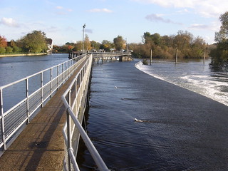
- Then you are on a tarmac path on the right-hand side of the lockhouse, your direction 60°, which, in 30 metres, leads you over a series of footbridge sections across the impressive Hambleden Weir .
- At the far end of the Weir go straight on, between close boarded fences, staying on the tarmac path as it swings to the left, and following a white arrow painted on a fence in front of you, your direction 20°. Keeping ahead your path soon takes you through a short alley between two white cottages (Old Millgate Cottage to your left) to come out onto the A4155 at Mill End.
- Turn right on this A road, your direction 115° for some 15 metres then cross it and take the path on your left beside the green swathe at a road junction. Now keep ahead on the pavement to the road signposted Hambleden, heading northwards. In 20 metres cross to the pavement on the other (right-hand) side of the road.
- In 330 metres, cross a car road that goes right to Rotten Row, to take a signposted footpath through a metal kissing gate to the right of a wooden fieldgate to enter The Hambleden Estate into a grassy field and continue straight on, initially parallel to the road on your left-hand side, in the same direction as before.
- Continue for 600 metres, exiting the field in its top left-hand corner through a metal kissing gate. Cross an earth farm road and enter the next grassy field through another metal kissing gate heading towards Hambleden Church. In a further 500 metres, the path comes out by a metal kissing gate beside a small bridge over a stream.
- Go through the gate, turn right to cross the samll bridge and keep ahead on the road into Hambleden Village, passing on your left-hand side the village deli and cafe and then the Church of St Mary The Virgin (well worth a visit and a picnic spot). Continue on through the village and at its end, on your right-hand side, you come to the suggested lunchtime pub, the Stag and Huntsman.
- After lunch and any exploring of the village and church, retrace your steps on the village’s approach road, passing the small bridge and metal kissing gate by which you arrived. Continue straight on, in 20 metres passing cottage no. 57 on your right-hand side and in a further 35 metres you come to the main road.
- Cross the main road, slightly to the left, to go up two steps onto a tarmac path, signposted as a public footpath [5], a metal pipe railing on its left-hand side, your direction 195°.
- Continue up this path, soon between hedges, passing a building on your left and in 90 metres pass through a wooden kissing gate to continue along the left-hand edge of a wood. After 25 metres, [!] take a right fork uphill (which is marked by a white arrow on a tree), your direction 190° and keep to this main uphill path, following white arrows, now with light woodland on both sides.
- In 270 metres you come to the top of the hill. In a further 15 metres, [!] ignore a path to your right to carry straight on downwards , your direction 240°.
- In a further 160 metres, and 20 metres before the edge of the wood (marked by a wooden swing gate at the exit), turn right on a bridleway, your direction 285°.
- Your route is straight on thereafter until you come to an earth car road. In 165 metres, you ignore a fork to the right and, in 75 metres, another going very sharp right. In 125 metres you leave the wood to continue along a tree-lined bridleway.
- In a further 250 metres, you come out on to an earth car road T-junction. Here turn right on this road, your direction 350°, in 55 metres passing cottages nos. 6 and 7 on the left-hand side. Ignore a left turn immediately after these cottages but in a further 10 metres [6], turn left on a signposted bridleway, initially a car-wide earth road, your initial direction 310°.
- Keep ahead on this track for 110 metres where you reach a fork in the way ahead (where previously there was a sign that read ‘Strictly no riding without permits). Here take the right fork , which now heads uphill, now on a grassy way, with grassy fields to left and right. In 90 metres the path steepens as it bears to the right with woodland to your left and a treeline to your right, now on a rutted, chalky path with uneven footbed with tree roots as you head up into Great Wood, your direction 310°. In a further 70 metres you enter The Great Wood (as marked on the OS map) following a public bridleway sign, your direction 305°.
- At the Wood's entrance ignore the car-wide earth fork to the right and keep ahead. Your route through the Wood is more or less straight on, gently uphill,in a northerly direction, ignoring all turn-offs, for some 1.5 km, following relatively clear white arrows on trees.
- In more detail: in 450 metres, you reach a plateau and pass between gate posts (on the far side of the right-hand post is a blue disc and a white arrow). Ignore a broad track heading downhill on your right and keep ahead. Ignore more ways off (in 210 metres one to the left, in another 45 metres one to the right and in a further 120 metres, one to the left). But then, in 90 metres, bear left for 30 metres, following white arrows on trees, before regaining your initial direction, now 325°. In 250 metres, ignore a fork sharply to the left and in 85 metres, one to the right.
- When the wood ends on your left-hand side, continue on a path with a fence on your left with Roundhouse Farm (as marked on the OS map) visible ahead of you, slightly to the left. This is a potentially muddy stretch, particularly in winter, of narrow bridleway,.
- In 500 metres, you come to a bench in front of Orchard House from which you have a fine view of the far slopes. In 90 metres, continue along an earth and gravel driveway, gently uphill. In 100 metres [7], you come out on to a tarmac road by the Round House where you turn left, your direction 190°.
- Keep on this country road, ignoring all ways off, for 1.5km. In more detail: in 270 metres you pass on your right-hand side the boarded up and disused building which was once the Walnut Tree pub.
- In 230 metres ignore a left turn signposted to Marlow, passing Fawley village green and well on your left. In a further 280 metres, at a minor road junction, keep straight on, in the direction of the sign to Henley. In a further 80 metres, you come on your right to the lychgate of St Mary the Virgin Church, Fawley, which is worth a visit.
- Continue along the road, now between hedges, for a further 400 metres, and ignore a footpath to the left by a house called Mavoli. In 250 metres [8] at a sharp bend in the road (to the right ) and with a yellow water marker (H100/2) and a 10 MPH road sign on your left, [!] turn left off the road and head down a gravel access road, a signposted public footpath, your direction 145°.
- In 100 metres you pass Five Gates House on your left-hand side. In a further 175 metres, you go past Last Cottage on your right and pass through a metal swing gate to the right of a metal fieldgate, with Homer House on your left-hand side. In a further 45 metres at a three-armed footpath sign, and just before a set of overwrought high iron gates, [!] turn sharp right through a wooden swing gate and head down an enclosed, narrow path with uneven footbed, your direction 230°. This path can be muddy in winter - and overgrown in summer.
- In 140 metres, you go through a metal barrier, cross a tarmac road and continue straight on, uphill, passing through a small wooden swing gate in 15 metres, onto a grassy way which swings to the left.
- In 80 metres, you go through a small wooden swing gate and onwards on a grassy way, now with woodland over to your left and open fields to your right. You head down a dip then up the other side, and in 140 metres you go through another small wooden swing gate and in 5 metres cross over a car lane, passing a small cattle grid and the gates to a water station over to your left. On the other side of the car lane go through another small wooden swing gate to continue ahead on a narrow path with fenceline and bushes on your left and brambles and undergrowth to your right.
- In 85 metres go through a small wooden swing gate to come out into a large open field and continue straight ahead along its right-hand edge. In a further 200 metres, go through a small wooden swing gate to a T-junction with a gravel car road [9] where you turn left, your direction 150°.
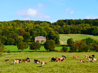
- Thereafter it is more or less straight on into Henley. But in more detail: in 300 metres, you come on your right to a white post announcing ‘Henley Park Private’ but you carry straight on. In 270 metres, you pass Henley Park, a cream coloured manor house, on your left-hand side. In a further 100 metres, you leave the car road, which bears left, [!] to keep ahead through a wooden kissing gate, marked Oxfordshire Way, with a pair of wooden fieldgates to its right, to continue straight on, your direction 150° to enter the grassy parkland of the Culden Faw Estate. In 450 metres pass to the right of a redundant metal kissing gate side to continue straight on, your direction now 165°. In a further 500 metres you exit the estate's grounds through a wooden kissing gate to head down through a wood.
- You exit the wood after some 180 metres and keep ahead down an enclosed path, with an open field to your right and latterly, a sportsfield to your left. In 250 metres you come down to the A4130 road [10], where you turn left , your direction 135°.
- Keep ahead along the pavement to the road (Northfield End) for some 320 metres and at the double roundabout, cross over and keep ahead (slightly right) to go down Bell Street.
- In 220 metres, you pass on your left-hand side New Street, with the famous Asquiths Teddy Bear Shop on the corner. Keep straight on along Bell Street for a further 170 metres, passing shops, cafes and restaurants on either side, until you reach a major cross road junction in the Centre of Henley . Here turn left into Hart Street, with Maison Blanc a potential tea stop, on the opposite corner.
- In 75 metres, you pass the Old Rope Walk tea place on your right-hand side and in a further 35 metres, Café Rouge on your left-hand side. In a further 40 metres you come to the Parish Church of St Mary the Virgin . (In summer at weekends you may find teas are served in the Chantry House here).
- Just before Henley Road Bridge turn right down Thames Side to retrace your earlier steps along the riverfront. In 50 metres you come to the Chocolate Cafe on your right-hand side (formerly known as the Henley Tearooms), the traditional tea stop for SWC walkers.
- Continue along the riverfront, passing the junction with Friday Street on your right, until you come to ‘Hobbs of Henley River Trips and Boats for Hire’ business ahead of you, where you bear right now on Station Road. In 125 metres turn left down the approach road to Henley Railway Station, which you reach on your left in 50 metres.
Reverse Walk (clockwise)
Out via Great Wood, a later lunch, and a gentle return along the Thames Path
- [1] Coming out of Henley Railway Station , turn right , your direction 305°, and walk down the approach road for 50 metres to the main road. Here, with what used to be the once grandiose Imperial Hotel opposite, turn right on Station road, your direction 45°.
- In 125 metres bear left passing ‘Hobbs of Henley River Trips and Boats for Hire” business.
- Continue along the road (now Thames Side) with the slipway and moorings beside the River Thames on your immediate right. In 160 metres, as the road swings to the left to become Friday Street, keep ahead on Thames Side, soon passing the Chocolate Café on your left-hand side. In 100 metres, at a T-junction with a main road and with the Angel pub on your right-hand side, and Henley Road Bridge to its right, turn left into Hart Street. On the opposite side of the road is the Red Lion Hotel – and soon to its left St Mary’s Church .
- Walk along Hart Street through Henley’s retail area. In 205 metres you come to a main road junction, with Duke Street on your left and Bell Street on your right. Here cross over Hart Street and turn right down Bell Street.
- Keep ahead along Bell Street, a continuation of Henley’s retail area. In 170 metres you pass New Street on your right, with the famous Asquiths Teddy Bear Shop on the corner. Continue along Bell Street for a further 220 metres, where you come to a double roundabout, which you cross over, and take the road to your left – Northfield End (the A4130) signed to Stonor Park, Wallingsford and Nettlebed.
- Keep along this road for 320 metres until you come to a signed footpath on your right – the Oxfordshire Way [!][10], with Rupert House playing fields to its right. Turn right up this path. You will now stay on this national footpath for 2 km, but in more detail:.
- Head up this enclosed earthen path, which becomes steeper by the time you enter a wood in 250 metres. The path then meanders uphill through the wood for 180 metres until you exit the wood through a wooden kissing gate to come out into parkland. On the gate is a notice stating you are entering the grounds of The Culden Faw Estate .
- Keep ahead now on a grassy way through Henley Park , gently uphill, your direction 340°. You pass individual trees (mostly oak) to left and right as you keep ahead over parkland. In 500 metres you pass a redundant metal kissing gate on your right-hand side and continue ahead, now on a level grassy way. In a further 450 metres go through a wooden kissing gate with a pair of wooden fieldgates to its right, to exit the grounds of the Culden Faw Estate onto an estate drive, at a bend in the road.
- Keep ahead along the drive, in 100 metres passing Henley Park, a cream coloured manor house, on your right-hand side. Continue along the drive for a further 270 metres, to a white post on your left announcing “Henley Park Private”. Keep ahead now on a gravel car road with a treeline to your right and fields on either side. In 300 metres, by a wooden marker post on your right-hand side with a yellow directional disk [!][9], turn right through a small wooden swing gate into a large open field and keep ahead close to its left-hand edge.
- In 200 metres at the end of the field go through a small wooden swing gate and keep ahead on an enclosed narrow path with brambles and undergrowth to your left and a fence and bushesd on your right. In a further 85 metres pass through wooden swing gates on either side of a car lane (with a small cattle grid to your right and beyond it gates to a water station).
- You now enter a grassy field, close to its right-hand edge. Ignore the grassy path directly ahead of you and instead bear right and head downhill keeping close to the right-hand edge of the field.
- You head down into a dip and up the other side and in 140 metres you go through a wooden swing gate and continue ahead, initially on the level but soon downhill. Over to your right you have woodland, and to your left open fields.
- In 80 metres pass through another small wooden swing gate, and in 15 metres, drop down to a tarmac road, which you cross over, to then pass through a metal barrier on the other side, to enter an enclosed path.
- Head up this narow path, with uneven footbed. In 140 metres, at the top of the path, go through a wooden swing gate and turn left – with a set of overwrought high iron gates to your right, and head up this access road, your initial direction 340°.
- In 45 metres go through a metal swing gate to the left of a metal fieldgate and continue up the access road, passing Homer House on your right-hand side. In a further 175 metres you pass Five Gates House on your right-hand side. Continue uphill until come out onto a main road at a T-junction [8]. Here turn right and head along this country road – Dobson’s Lane - with hedgerows on either side (taking care as there is no pavement).
- In 250 metres ignore a footpath on your right by a house called Mavoli. In a further 400 metres you pass on your left the lychgate to the Church of St Mary the Virgin, Fawley (which is worth a visit). Continue along the road and in 80 metres you pass on your left-hand side a minor road junction. In a further 280 metres you pass on your right Fawley Village Green with its well and bench, at a road junction on your right to Marlow. In 230 metres you pass on your left-hand side what used to be the Walnut Tree pub, now a semi-derelict property.
- In 270 metres, as the road swings to the left [!] and with a house on your right called Round House [7], bear right onto a signed footpath over a gravel area then onto an earth and gravel driveway, your direction 40°, downhill. In 100 metres the driveway becomes a narrow bridleway with a hedgerow – and soon woodland - to your left and open fields to your right behind a wire fence. This narrow path can be very muddy in winter.
- In 90 metres you come to a bench by Orchard House from which you have a fine view of the far slopes. In a further 500 metres you enter The Great Wood . You will follow a bridleway track gently downhill as it meanders through this wood through bends and some sharp turns for some 1.5 km, in a southerly direction, but in more detail:.
- Ignore all ways off to the left then right. On entering the wood your bearing is 160°.The route of the bridleway track is marked on a regular basis by white arrows on trees, although the track is fairly clear to follow.
- Some 1 km after entering the wood you ignore a broad track going downhill to your left and pass through a pair of wooden gate posts to come onto a flat plateau. On the left-hand gate post is a blue disc and a white arrow.
- Keep ahead, your direction now 140°,and you soon start to go downhill again. In 450 metres you exit the wood as the bridleway narrows and you head downhill, initially steeply, on a rutted chalky path with uneven tree root footbed, with woodland to your right. You are descending Reservoir Hill. In 240 metres you leave the woodland behind to come out into the open, as you keep ahead now down a grassy way. Soon your way begins to level out, between grassy fields. In 220 metres your way comes out onto an access road, by a three-armed sign, where you turn right .
- In 10 metres [6] ignore a right turn and pass cottages Nos 6 and 7 on your right. In a further 55 metres [!] turn left onto a bridleway, your direction 60° with an open field to your right and treeline to your left.
- In 250 metres you enter woodland on what is now a car-wide earthen track. In a further 125 metres ignore a fork going very sharply left. In 75 metres ignore a turn to the left. In another 165 metres [!] you come to a junction with a wooden swing gate some 20 metres down to your right at the edge of the wood.
- At this junction [!] take the narrow bridleway path on your left, heading uphill , your direction 60°. The path is quite steep in places as it meanders uphill through woodland. In 160 metres at a path T-junction by a marker post, ignore the path to the left and take the right-hand path, almost directly ahead of you and then keep ahead through light woodland and undergrowth, now on a footpath. The path bears left at the top of the hill and you soon begin to head steadily downhill.
- In 270 metres you go through a wooden kissing gate and drop down a tarmac path, soon with a metal railing on your right-hand side. The tarmac path comes out down two steps to a tarmac road, a few metres from a road junction.
- You cross over the road and turn right on the minor road (signed Pheasant’s Hill, Frieth and Lane End) into the picturesque village of Hambleden . The road swings to the right and you pass the village store on your left then Hambleden Church. Continuing along the road you next come to The Stag and Huntsman pub on your right-hand side, the suggested lunch stop.
- After lunch retrace your steps through the village towards the road junction, but some 55 metres before the junction [!] at a two-way sign, turn left through a metal kissing gate by a small bridge over a stream into a grassy field, your direction 140°. You are following the direction of the sign “Circular walk”.
- Keep ahead on a grassy path through the field, which can be muddy in winter. In 500 metres exit the field through a metal kissing gate. Cross an earth farm track and go through another metal kissing gate onto a path through the next grassy field, your direction now due south.
- In 600 metres exit the field through another metal kissing gate, turn right for a few metres on the minor road that goes left to Rotten Row and at the road junction turn left to re-join the road (which has been parallel to your way on the right). Keep ahead along the pavement of the road for 330 metres, then cross over to head down the pavement on the right-hand side.
- In 20 metres and just before you reach the T-junction with the A4155 road at Mill End keep ahead on the path with grass to its left that takes you out onto the A road opposite the entrance to Hambleden Marina. Here turn right for 15 metres, then cross the A road with care to go down the signposted path ahead of you, down an alley between two white cottages.
- Follow the signposted, fenced-in path ahead then right. Now walk along the metal footbridges over the impressive Hambleden Weir , at times stopping to marvel at the force of the water cascading over the various sections of this long weir.
- At the far end of the weir you head for Hambleden Lock [4] along a tarmac path on the left-hand side of the lockhouse to then cross over the lockgates. On the far side turn right – following the sign Thames Path Henley 2.5 miles - over a brick-paved walkway with the lock on your right-hand side. In 70 metres at the end of the paving turn left through a wooden swing gate and then turn right on a grassy way, with the banks of The River Thames on your right, your initial direction 300°.
- You now commence your Thames Path Walk of some 4 km all the way back to Henley. Sections of the path can be flooded in winter.
- In 1.25 kms you pass Temple Island over to your right. 500 metres further on [3] you pass the signed path on your left which leads in some 200 metres to the Church of St Nicholas, Remenham .
- In 1.75 kms the Thames Path heads up a tarmac lane to your left, in 55 metres coming to Henley Road Bridge . Turn right along the bridge, and at its far end, with the Angel Hotel ahead of you on your left, cross over the road at the traffic lights and turn left down Thames Side road, to retrace your outward steps to Henley Railway Station .
- Some 50 metres down Thames Side on your right-hand side you have The Chocolate Café – a tea-stop popular with SWC walkers.