Henley via Stonor Circular Walk
Long walk through the Chilterns over gentle rolling grassy hills. Historic riverside Henley for tea.
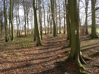
Woods near Bix winter
Henley via Stonor walk
Jan-06 • Saturdaywalker on Flickr
swcwalks book2 walk6 walkicon 30725809716
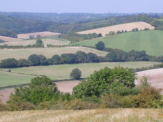
walk_06_pc_View_from_hill__before_Middle_Asendon_picnic_spot
Sep-04 • Peter Conway on Flickr
swcwalks book2 walk6 36486989264
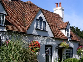
walk_06_pc_Rainbow_pub _Middle_Assendon
Sep-04 • Peter Conway on Flickr
swcwalks book2 walk6 36927356060


Hidden valleys of the southern Chilterns
| Length |
Main walk: 23.4km (14.5 miles) Via afternoon short cut (no lunch pub): 19.1km (11.9 miles) Old route to closed lunch pub in Pishill: Adds 3.1km (1.9 miles) Short Walk: 14.4km (8.9 miles) |
|---|---|
| Maps | OS Landranger Map No 175. OS Explorer Map No 171 |
| Toughness | 6 out of 10 |
| Features | Henley is normally thought of as a riverside town but, as this walk demonstrates, it is also on the southern edge of the Chiltern Hills, a charming area of hidden valleys, mixed woodland and farmland, and largely gentle slopes. The walk takes in all aspects of this scenery, including some fine beech woods which display golden colour in the autumn, as well as excellent panoramic views. This is also a wonderful walk in which to see red kites, a bird of prey that has been successfully re-introduced here, and which can often be seen wheeling slowly overhead. Following the closure in 2020 of the original lunch pub for this walk - the Crown in Pishill - a new route has been created to take in lunch at the White Hart in Nettlebed. This also passes through some excellent woodland scenery. It is not clear if the Crown will reopen, but the route to it has been retained as an option: see below. |
| Walk Options |
- Afternoon short cut: If you don't want to have lunch at the White Hart in Nettlebed, you can trim 4.3km (2.7 miles) off the main walk by using this short cut, making the total walk 19.1km (11.9 miles). This does miss out some fine wood and hill scenery, however. - The route to the former lunch pub for this walk, the Crown in Pishill, has been retained as an option in the GPX and directions just in case the pub reopens. This adds 3.1km (1.9 miles) to the walk. However, when combined with the afternoon short cut above it makes a walk of 22.2km (13.8 miles). - Short walk: A short walk up country lanes from Middle Assendon allows you to shorten the route to 14.4km (8.9 miles). This short walk still takes in several of the best sections from the the main walk, and makes an excellent winter outing. However, note that the lunch pub for this walk, the Rainbow in Middle Assendon, is currently (November 2024) closed and about to be sold: it is not clear if it will reopen as a pub. |
| Transport |
There are twice hourly connections from London Paddington to Henley-on-Thames, changing at Twyford; though later in the evening the trains revert to hourly. Journey time is about one hour. If aiming for lunch in Nettlebed, get the train nearest to 9am. A train an hour later would be fine for the Rainbow. |
| Lunch |
The Rainbow Inn in Middle Assendon, 5km (3.1 miles) into the walk, was formerly the lunch pub for the short walk and an early lunch option on the main walk. However in September 2024 it closed on the retirement of its licensee. In November 2024 it was showing a "Sale Agreed" sign. It is not yet clear if it will reopen as a pub. The Crown Inn in Pishill, 10.9km (6.8 miles) from the start of the walk, was the former lunch stop for the main walk, but has been closed since 2020. The main walk route has now been diverted to the White Hart below. The White Hart in Nettlebed (01491 641245), 12.8km (8 miles) from the start of the walk, is the new lunch pub for the main walk. A former coaching inn that has been very pleasantly modernised, it serves tasty food in large portions. It has a patio area out back with outside seating. It is open all afternoon daily and serves food all day, but with a reduced menu of sandwiches, salads, burgers and pizza from 3pm to 6pm. On Sundays there is a carvery from 12pm to 4pm. A fine picnic spot on the main walk is at the top of the hill opposite Stonor Park house (paragraph 34 on page 4 in the walk directions). |
| Tea | The Chocolate Cafe Henley-on-Thames (01491 411412). There are many tea options in Henley, but this café, situated on the waterfront by the bridge has a particularly fine selection of chocolate cakes. It is open till 5pm daily, but sometimes later on summer weekends. This is the suggested tea stop on all the walks. The Angel Inn more or less across the road is a pleasant pub stop. |
| History |
Henley is supposed to be the oldest settlement in Oxfordshire, dating at least from Roman times, but it really came into its own from the 12th century onward as a river crossing and a port for shipping grain and timber to London. These days the town has a much more refined air. It is supposed to have 300 listed buildings and is famous for its annual Regatta, held in the first week of July since 1839. A recent famous resident was the Beatle George Harrison, whose former house (or its heavily barbed-wired garden fence) is passed on this walk. The stately home of Stonor Park can be seen across the valley in paragraph 34 of the walk directions, and its entrance is in paragraph 121, just off the main walk route. It has been owned by the Stonor family for 850 years and parts of the house date back to the 12th century, though it also has plenty of Tudor and even Georgian features. It was one of the places where the 16th century Catholic martyr (and now a saint) Edmund Campion stayed and preached. The house and its gardens and cafe are open on selected days from Easter to October - see www.stonor.com. Though it looks like an ancient ruin, the abandoned church in Bix Bottom just before Valley End Farm only fell into disuse in 1875. Before that, it was the Church of St James, which had features dating back to Norman times. |
| Book |
This walk was originally published in Time Out Country Walks near London volume 2. We now recommend using this online version as the book is dated. |
|---|---|
| Profile | |
| Help Us! |
After the walk, please leave a comment, it really helps. Thanks! You can also upload photos to the SWC Group on Flickr (upload your photos) and videos to Youtube. This walk's tags are: |
| By Train |
Out (not a train station) Back (not a train station) |
| By Car |
Start Map Directions |
| Amazon | |
| Help |
National Rail: 03457 48 49 50 • Traveline (bus times): 0871 200 22 33 (12p/min) • TFL (London) : 0343 222 1234 |
| Version |
Nov-24 Peter |
| Copyright | © Saturday Walkers Club. All Rights Reserved. No commercial use. No copying. No derivatives. Free with attribution for one time non-commercial use only. www.walkingclub.org.uk/site/license.shtml |


Walk Directions
Full directions for this walk are in a PDF file (link above) which you can print, or download on to a Kindle, tablet, or smartphone.
This is just the introduction. This walk's detailed directions are in a PDF available from wwww.walkingclub.org.uk