Henrhyd Waterfalls (Sgwd Henrhyd) from Craig y Nos walk
Rewarding walk through Craig y Nos Country Park and above the Tawe River or via the Cribarth limestone plateau, then up a scenic wooded gorge to South Wales' highest waterfall

Small Waterfall in the Nant Llech Valley (Close-up)
SWC Walk 280 Henrhyd Falls - Sgwd Henrhyd (Craig y Nos Circular)
Oct-16 • thomasgrabow on Flickr
swcwalks swcwalk280 banner 30550809576
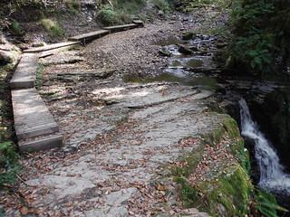
Boardwalk to side of another waterfall on the Nant Llech
SWC Walk 280 Henrhyd Falls - Sgwd Henrhyd (Craig y Nos Circular)
Oct-16 • thomasgrabow on Flickr
swcwalks swcwalk280 walkicon 29953579593

Cribarth Plateau from across Cwm Tawe
SWC Walk 280 Henrhyd Falls - Sgwd Henrhyd (Craig y Nos Circular)
Oct-16 • thomasgrabow on Flickr
swcwalks swcwalk280 walkicon 30499636751

Craig y Nos Castle, from A4067
SWC Walk 280 Henrhyd Falls - Sgwd Henrhyd (Craig y Nos Circular)
Oct-16 • thomasgrabow on Flickr
swcwalks swcwalk280 walkicon 30470893422
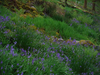
Bluebells in Abercrave Wood on Descent from Cribarth Plateau (Detail)
SWC Walk 280 Henrhyd Falls - Sgwd Henrhyd (Craig y Nos Circular)
May-17 • thomasgrabow on Flickr
swcwalks swcwalk280 walkicon 33665315383

SWC Advance Group behind Sgwd Henrhyd's Curtain of Water
SWC Walk 280 Henrhyd Falls - Sgwd Henrhyd (Craig y Nos Circular)
May-17 • thomasgrabow on Flickr
swcwalks swcwalk280 walkicon 24946732327

Craig y Nos Castle through trees
SWC Walk 280 Henrhyd Falls - Sgwd Henrhyd (Craig y Nos Circular)
Oct-16 • thomasgrabow on Flickr
swcwalks swcwalk280 30551541956
| Length |
13.4 km (8.3 mi), with 296m ascent/descent. For alternative start points, resulting in a shorter or a longer walk, see below Walk Options. |
|---|---|
| Toughness |
3 out of 10 Time, with 4 hours walking time. |
| Walk Notes |
From the Craig y Nos Country Park, an idyllic spot on the banks of the Afon Tawe (River Tawe) with its Victorian Gothic building (now a hotel), which was home to the world renowned opera singer Adelina Patti from 1878 to 1919, the route follows quiet bridleways and country lanes with excellent views across the valley to the Cribarth mountain, to a steep cliff edge above the Tawe River which it then follows for an extended stretch, with the river running below in rapids.
A variation of the start leads over the limestome Cribarth Plateau with its shakeholes and far views. |
| Walk Options |
A triangular section along cliffs above the Tawe River, up the Nant Llech valley to the Henrhyd Falls and back through fields and lanes is the core of this walk, with lunch pub and tea stop, if ending at Craig y Nos. Alternative Start Points are described; these are:
These points are linked to the start by the T6 bus line and can also be Alternative Finish Points. A variation of the start leads over the Cribarth Plateau; this adds about 300m ascent (6/10). |
| Maps | OS Explorer: OL12 (Brecon Beacons National Park)
OS Landranger: 160 (Brecon Beacons) Harvey Superwalker XT25: Breacon Beacons West/Bannau Brycheiniog Gorllewin Harvey British Mountain Map: Breacon Beacons/Bannau Brycheiniog |
| Travel |
Craig y Nos Bus Stop, map reference SN 840 153, is 249 km west of Charing Cross, 209m above sea level and in the Tawe (or Swansea) Valley (Cwm Tawe) in Powys, Wales. It is on line T6 (Swansea - Neath - Ystradgynlais – Brecon), with 11 buses a day Mon-Sat and 5 on Sundays and Bank Holidays, with a journey time of 40 mins from Neath (and 37 mins from Brecon). The journey time by train from London to Neath is from 2 ¾ hours.
Saturday Walkers’ Club: This walk is doable as a daywalk from London, if you have motorised transport. |
| Lunch and Tea |
In Pen y Cae
In Ynyswen/Abercrave
In Craig y Nos
In Glyntawe
|
| Stay | Accommodation is available in Craig y Nos, nearby in Glyntawe or Pen y Cae, and further along the bus line in Ystradgynlais, Sennybridge or Brecon. |
| Brecon Beacons |
The Brecon Beacons National Park is in south Wales. It consists of bare, grassy, glacial mountains, with north facing escarpments. Its peaks, just shy of 1,000m (3,000ft), are the highest mountains in the southern UK. The national park is also noted for reservoirs, and the Dan yr Ogof caves. Its 4 mountain areas, from west to east are:
|
|---|---|
| Welsh Glossary |
aber: estuary, confluence, river mouth; afon: river; affwys: abyss; allt: hillside, cliff; aran: high place; ban/fan/bannau (pl): peak/beacon/crest, hill/mountain; big: peak; blaen: source of river, head of valley; bod: dwelling; bre: hill; bron: hill-breast; bryn: hill; bwlch: gap/col/pass; cadair: chair; cae: field; caer/gaer: stronghold, fort; capel: chapel; carn/garn/carnedd/garnedd: cairn, heap of stones, tumulus; carreg/garreg: stone, rock; castell: castle; cefn: ridge, hillside; celli: grove/copse; cerwyn: pot-hole; cist: chest; clog/clogwyn: cliff; clun: meadow; clwyd: hurdle/gate; clydach: torrent; coch/goch: red; coed: wood; craig/graig: rock; crib/cribyn: crest, ridge, summit; crug: mound; cul: narrow; cwm: hanging valley/corrie/bowl/dale; cyfrwy: ridge between two summits (saddle); ddinas: fort; dibyn: steep slope, precipice; dim: no; din: hill-fortress; disgwylfa: place of observation, look-out point; dôl: meadow; du/ddu: black, dark; dwfr/dŵr: water; dyffryn: valley; -dyn: fortified enclosure; eglwys: church; eira: snow; eisteddfod: meeting-place, assembly; esgair: ridge; fach/bach: small; fawr/mawr: large; fechan: smaller; ffald: sheep-fold, pound, pen, run; ffordd: way, road; ffridd: pasture; ffrwd: stream, torrent; ffynnon: spring/well; gallt: wooded hill; ganol: middle; garth: promontory, hill, enclosure; glan/lan: river-bank, hillock; glas: green (when referring to grass, pasture or leaves), blue (when relating to the sea or air); glyn: deep valley, glen; gors: bog; gorsedd: tumulus, barrow, hillock; gwyddfa: mound, tumulus; gwylfa: look-out point; gwyn/gwen: white; gwynt: wind; hafn: gorge, ravine; hafod: summer dwelling; hen: old; hendre(f): winter dwelling, old home, permanent abode; heol: road; hesgyn: bog; hir: long; is: below, lower; isaf: lower/lowest; llan: church, monastery; llawr: level area, floor of valley; llech: slab, stone, rock; llther: slope; lluest: shieling, cottage, hut; llwch: lake, dust; llwybr: path; llwyd: grey, brown; llwyn: bush, grove; llyn: lake; llynwyn: pool/puddle, moat; maen: stone; maes: open field, plain; mawn: peat; mawnog: peat-bog; melyn: yellow; merthyr: burial place, church; moel/foel: bare, bald/bare hill; mynydd: mountain, moorland; nant: brook/stream, dingle/glen; neuadd: hall; newydd: new; ogof/gogof: cave; pant: hollow; parc: park, field, enclosure; pen: head, top/end, edge; penrhyn: promontory; pentre(f): homestead, village; perfedd: middle; perth: bush, brake, hedge; plas: hall, mansion; pont/bont: bridge; porth: gate/gateway, harbour/bay/landing-place/ferry; pwll: pit, pool; rhiw: hill, slope; rhos: moor, promontory; rhudd: red, crimson; rhyd: ford; sarn: causeway; sgwd/rhaeadr: waterfall; sticill: stile; sych: dry; tafarn: tavern; tâl: end, top; talar: headland (of field); tan/dan: below; tarren/darren: escarpment; tir: land, territory; tor: break, gap; tre/tref: settlement, hamlet, town; twlch: tump, knoll; twll: hole, pit; tŵr: tower; twyn: hill; tŷ: house; uchaf: upper, highest; uwch: above, over; waun/gwaun: moorland, meadow; wen/wyn: white; y, yr, ‘r: the; ynys: island, holm, river-meadow; ysgol: ladder, formation on mountain-side/school; ysgwydd: shoulder (of mountain); ystafell: chamber, hiding-place; ystrad: wide valley, holm, river-meadow. |
| Profile | |
| Help Us! |
After the walk, please leave a comment, it really helps. Thanks! You can also upload photos to the SWC Group on Flickr (upload your photos) and videos to Youtube. This walk's tags are: |
| By Car |
Start Bus Stop, Craig y Nos, Powys, SA9 1GL Map Directions |
| Amazon | |
| Help |
National Rail: 03457 48 49 50 • Traveline (bus times): 0871 200 22 33 (12p/min) • TFL (London) : 0343 222 1234 |
| Version |
Apr-24 Thomas G |
| Copyright | © Saturday Walkers Club. All Rights Reserved. No commercial use. No copying. No derivatives. Free with attribution for one time non-commercial use only. www.walkingclub.org.uk/site/license.shtml |


Walk Directions
Full directions for this walk are in a PDF file (link above) which you can print, or download on to a Kindle, tablet, or smartphone.
This is just the introduction. This walk's detailed directions are in a PDF available from wwww.walkingclub.org.uk