High Cup Nick (Appleby-in-Westmoreland Circular) walk
One of the finest natural features in northern England, the spectacular High Cup Nick, on good paths and with easy route finding
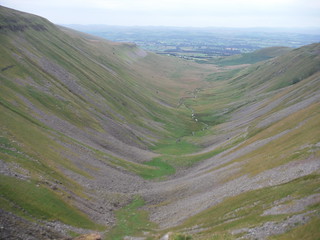
High Cup, from High Cup Nick
SWC Walk 415 - High Cup Nick (Appleby-in-Westmoreland Circular)
Jul-22 • thomasgrabow on Flickr
swcwalks swcwalk415 banner 53042334372

High Cup Nick
SWC Walk 415 - High Cup Nick (Appleby-in-Westmoreland Circular)
Jul-22 • thomasgrabow on Flickr
swcwalks swcwalk415 walkicon 53043407443
![High Cup from near Brackenthwaite Farm SWC Walk 415 - High Cup Nick (Appleby-in-Westmoreland Circular) [Shortcut]](https://live.staticflickr.com/65535/53043098339_a82903b7fc_n.jpg)
High Cup from near Brackenthwaite Farm
SWC Walk 415 - High Cup Nick (Appleby-in-Westmoreland Circular) [Shortcut]
Jul-22 • thomasgrabow on Flickr
swcwalks swcwalk415 walkicon 53043098339
![Mickle Fell beyond Maize Beck SWC Walk 415 - High Cup Nick (Appleby-in-Westmoreland Circular) [Extension via Warcop Range and Scordale]](https://live.staticflickr.com/65535/53042927096_98d52fa29a_n.jpg)
Mickle Fell beyond Maize Beck
SWC Walk 415 - High Cup Nick (Appleby-in-Westmoreland Circular) [Extension via Warcop Range and Scordale]
Apr-23 • thomasgrabow on Flickr
swcwalks swcwalk415 walkicon 53042927096
![View down Scordale towards Roman Fell from Scordale Head SWC Walk 415 - High Cup Nick (Appleby-in-Westmoreland Circular) [Extension via Warcop Range and Scordale]](https://live.staticflickr.com/65535/53042927271_3e50bcfee1_n.jpg)
View down Scordale towards Roman Fell from Scordale Head
SWC Walk 415 - High Cup Nick (Appleby-in-Westmoreland Circular) [Extension via Warcop Range and Scordale]
Apr-23 • thomasgrabow on Flickr
swcwalks swcwalk415 walkicon 53042927271
![Backview up Scordale's area of intense mining SWC Walk 415 - High Cup Nick (Appleby-in-Westmoreland Circular) [Extension via Warcop Range and Scordale]](https://live.staticflickr.com/65535/53042927701_5f266de9c5_n.jpg)
Backview up Scordale's area of intense mining
SWC Walk 415 - High Cup Nick (Appleby-in-Westmoreland Circular) [Extension via Warcop Range and Scordale]
Apr-23 • thomasgrabow on Flickr
swcwalks swcwalk415 walkicon 53042927701
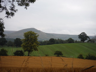
Murton Pike, from Stank Lane
SWC Walk 415 - High Cup Nick (Appleby-in-Westmoreland Circular)
Jul-22 • thomasgrabow on Flickr
swcwalks swcwalk415 53043096569
| Length |
23.9 km (14.8 mi), with 748m ascent/descent. For a shorter or longer walk, see below Walk Options. |
|---|---|
| Toughness |
8 out of 10, with 6 ½ hours walking time. |
| Walk Notes |
This is an exhilarating exploration of one of the finest natural features in northern England, the spectacular High Cup Nick, an almost geometrically perfect U-shaped glaciated valley, deeply incised into the Northern Pennine scarp, from Appleby, a market town on the River Eden in Cumbria, famous for its annual Appleby Horse Fair, with views across the Eden Valley to the Lake District and the Howgill Fells.
|
| Walk Options |
Cut the out-and-back to the top of Murton Pike: cut 900m distance and 76m ascent.
Short and Main Walk, after their split at High Cup Nick, run parallel for the first kilometre, but at different heights. You could start along the Short Walk route along the rim of the Nick and then climb up to the Main Walk route along the bridleway along the wall (the turn is obvious from text and route map).
Outbound and return route are never too far away from each other. This enables car drivers to shorten the route by parking higher up the route, along the road linking Murton (on the main and long walk) and High Cup House (on the short walk) with Dufton/Bow Hall via Keisley (both on the outbound route).
|
| Maps |
OS Landranger: 91 (Appleby-in-Westmorland) & 98 (Wensleydale & Upper Wharfedale)
|
| Travel |
Appleby-in-Westmorland Station, map reference NY 686 206, is 377 km northwest of Charing Cross, 45 km southeast of Carlisle, 161m above sea level and in Cumbria. It is a station on the Leeds - Settle – Carlisle Line, with eight trains per day Mon-Sat and seven on Sundays. Journey time is 42 minutes from Carlisle, 56 from Settle and 118 from Leeds. Saturday Walkers’ Club: The walk is not practicable as a daywalk from London. |
| Lunch | Picnic |
| Tea |
The Midland Hotel Freehouse 25 Clifford Street, Appleby-in-Westmorland, Cumbria CA16 6TS (017683 51524). The Midland is located right by the train station. Numerous options in Appleby on a loop to and through the town centre (this adds 2.2 km and 85m ascent). See the walk directions for details. |
| Northern Glossary |
beck: stream, brook; brig(g): bridge; -by: habitation; cam: bank, slope, ridge; carr: marshy woodland or shrubland; clough: narrow valley, cleft in a hillside, ravine, glen, gorge, cliff, rocky precipice; crag: steep rugged mass of rock projecting upward or outward; currick: cairn, pile of stones, often locations used to keep watch for Scottish raiders; dale: valley; -ey: island, dry area in a marshy place; fell: hill, mountain slope (especially rough moorland); firth/frith: long, narrow inlet of the sea or estuary; force/foss: waterfall, rapids; frith: area of peace, protection, safety, security, pasture; garth: small grass enclosure adjacent to a house; gate: way, street; gill/ghyll: small narrow valley or ravine;hagg: part of an area of woodland, especially on a sloping bank; holm(e): island, inland promontory, raised ground in marsh, river-meadow; how(e): barrow, small hill; hush: (Roman era) mine on steep hillside, using dammed up water to wash away topsoil and boulders, revealing the underlying lead or ore veins; ing(s): meadow(s), especially water meadow near a river; keld/kell: spring or well; kirk: church; laithe/leeath: barn, agricultural building; lang: long; ling: heather; lonning/lonnin’: lane or track, something less than a road, more rural than a street, usually short; mell: sand dunes; mire: bog; moss: bog, marsh; ness: headland, promontory; nick: shallow notch, cut or indentation on an edge or a surface; pike: spike, sharp point, peak; rake: slant, incline; rigg: ridge; scar/scaur: cliff, rocky outcrop with a steep face; seat/set(t)/side: summer pasture or dwelling place; seaves: rushes; shaw: hurdle, gate; sike/syke/sitch: small stream or gulley, gutter; stang: pole, shaft, stake, wooden bar; stoop/stowp/stoup: post, gatepost, distance marker (milestone), standing stone; -sty: ascent, ascending lane or path, narrow pathway or course; tarn: lake or pond (especially in an upland location); thorp(e)/t(h)rop: village or small settlement; thwait(e): village or small settlement; toft(s): small farmstead with enclosed land, later applied to a village or small settlement; wath: ford; whinny: gorse, furze, thorny vegetation; -wich/wick: village or settlement. |
| Profile | |
|---|---|
| Help Us! |
After the walk, please leave a comment, it really helps. Thanks! You can also upload photos to the SWC Group on Flickr (upload your photos) and videos to Youtube. This walk's tags are: |
| By Train |
Out (not a train station) Back (not a train station) |
| By Car |
Start CA16 6TT Map Directions |
| Amazon | |
| Help |
National Rail: 03457 48 49 50 • Traveline (bus times): 0871 200 22 33 (12p/min) • TFL (London) : 0343 222 1234 |
| Version |
Apr-24 Thomas G |
| Copyright | © Saturday Walkers Club. All Rights Reserved. No commercial use. No copying. No derivatives. Free with attribution for one time non-commercial use only. www.walkingclub.org.uk/site/license.shtml |


Walk Directions
Full directions for this walk are in a PDF file (link above) which you can print, or download on to a Kindle, tablet, or smartphone.
This is just the introduction. This walk's detailed directions are in a PDF available from wwww.walkingclub.org.uk