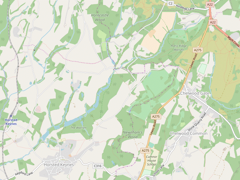
Horsted Keynes Circular walk
A varied walk from the deep wooded valleys of the High Weald to the elevated heathland of Ashdown Forest, with a section alongside the Bluebell Railway. Travel by bus.
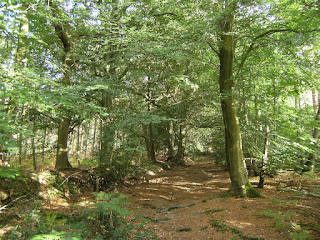
DSCF9702
Through Stumblewood Common
Sep-11 • Sean O'Neill
swcwalk132, swcwalks, walkicon 5665887887634668786 P
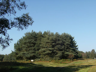
DSCF9808
MacMillan Clump, Ashdown Forest
Sep-11 • Sean O'Neill
swcwalk132, swcwalks, walkicon 5665887930492361586 P
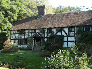
DSCF0017
Old Mill House, Horsted Keynes
Oct-11 • Sean O'Neill
swcwalk132, swcwalk141, swcwalk174, swcwalks, walkicon 5746053402912684626 P

DSCF0017
Old Mill House, Horsted Keynes
Oct-11 • Sean O'Neill
swcwalk132, swcwalk141, swcwalk174, swcwalks, walkicon 5665887190752460018 P

DSCF0028
Broadhurst Lake
Oct-11 • Sean O'Neill
swcwalk132, swcwalk174, swcwalks, walkicon 5665887552233407186 P

CIMG3414
Horsted Keynes Station from Leamland Bridge
Aug-12 • Sean O'Neill
swcwalk132, swcwalk174, swcwalks, walkicon 5866303785643129378 P

CIMG3414
Horsted Keynes Station from Leamland Bridge
Aug-12 • Sean O'Neill
swcwalk132, swcwalk174, swcwalks, walkicon 5781305504463936034 P
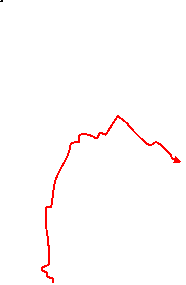
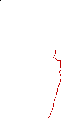
| Length |
Main Walk: 17½ km (10.9 miles). Four hours 20 minutes walking time. For the whole excursion including trains, sights and meals, allow at least 10 hours. Alternative Start, from the station: 18½ km (11.5 miles). Four hours 35 minutes walking time. |
|---|---|
| OS Map |
Explorer 135. Horsted Keynes, map reference TQ384282 (village), is in West Sussex, 7 km NE of Haywards Heath. |
| Toughness |
5 out of 10 (4 with short cuts). |
| Features |
This walk explores the undulating countryside between Ashdown Forest and the village of Horsted Keynes (pronounced canes: see Walk Notes), strung out along a broad village green with its interesting parish church of St Giles perched on a neighbouring hill. Harold MacMillan (Prime Minister 1957–1963) and members of his family are buried in the churchyard; the walk route passes his home (Birch Grove House) just before Chelwood Gate. The most practical way of travelling to this walk is on Metrobus 270 (see Transport below), but for a more stylish approach you could travel via East Grinstead to the nicely-preserved Horsted Keynes station on the Bluebell Railway, one of the oldest and most successful preservation railways in the country. All the walk options except those with the morning short cut go alongside the heritage railway for almost 1 km, so however you arrive there is a good chance of seeing a steam train chugging by. As with any walk in the High Weald, you will need to be prepared for muddy or waterlogged paths at almost any time of the year. |
| Walk Options |
Shorter routes are described for both the morning and afternoon sections, reducing the walk by 2¼ km and 3 km respectively. The first omits the interesting section alongside the Bluebell Railway but goes past a series of attractive fishing lakes. The second takes a more direct route from the lunch pub, omitting most of the stretch through Ashdown Forest. An Alternative Start is available from Horsted Keynes station. You could choose this option not only if you travel out on the Bluebell Railway, but at times when the 270 calls there on its way to the village; when returning by bus you have the option of finishing in the village instead of completing a full circular walk. The afternoon short cut is also available with this variation. You could in fact start and finish the circular walk at several other places as the 270 bus route takes in Chelwood Gate, Wych Cross and Chelwood Common; the directions point out the locations of the relevant bus stops. This walk shares the same lunch pub in Chelwood Gate with the Forest Row Circular walk (#23), so you could combine the morning of one with the afternoon of the other. There is also some overlap with the Horsted Keynes variation of the Haywards Heath to Balcombe walk (#174b·c) which covers the same ground between Horsted Keynes and the Bluebell Railway crossing (in the reverse direction). |
| Transport |
This walk has been designed around Metrobus 270, which runs hourly (two-hourly Sun & BH) between Brighton, Haywards Heath and East Grinstead. The bus stops at the western end of the village green, and also at the Bluebell Railway station on weekends. It is quicker to travel via Haywards Heath but it is useful to be able to return in either direction; the last service to Haywards Heath is at around 6pm (5pm Sun & BH), but there are one or two later services to East Grinstead (2023). Haywards Heath is on the main Brighton line, with frequent Thameslink services from St Pancras, Blackfriars and London Bridge, plus Southern trains from Victoria. The journey time from London Bridge or Victoria is around 40-45 minutes. On the Thameslink route you can get cheap Super Off-Peak tickets from central and north London (Sat, Sun & BH), but these are not valid on Southern services. The 270 bus stop is in Perrymount Road, just round the corner from the station forecourt. If you want to connect with the heritage railway, East Grinstead has a half-hourly Southern service from Victoria taking around 55 minutes. You also have the option of taking Metrobus 270 on this route; the bus stop is on the station forecourt. As Haywards Heath and East Grinstead are on different lines a return ticket to one is unlikely to be accepted for travel back on the other (especially a “Thameslink only” ticket at East Grinstead). If you do this, be prepared to buy a separate single ticket for the return journey. If driving, there are free car parks in Horsted Keynes village and at the Bluebell Railway station. |
| Suggested Train |
You should aim to start the full walk at around 10.30-11am, for example by taking a train to Haywards Heath which will connect with the Metrobus 270 service at around 10:20 (on the current timetable). If you catch a later bus, consider doing one of the shorter starts. |
| Train Times |
|
| Timetables |
|
| Lunch |
The most convenient lunch place (after 9 km on the Main Walk and 7¼ km on the Alternative Start) is the Red Lion (01825-740836) in Chelwood Gate, an up-market country pub/restaurant which serves food all afternoon. The alternative is to make a short detour later on to the Roebuck Hotel (01342-823811) at Wych Cross. If you start from an alternative location such as Wych Cross, you could have lunch at one of the pubs in Horsted Keynes (see below). |
| Tea |
There are two friendly pubs in Horsted Keynes for refreshment at the end of the walk, the Crown Inn (01825-791609) and the Green Man (01825-790656), although the latter is usually closed on weekday afternoons. Alternatively, you could catch the bus first and have tea while waiting for the train: there is a café in the large Waitrose next to Haywards Heath station, plus other refreshment options in and around the station. If you finish at the Bluebell Railway station the King George Ⅴ Buffet on Platforms 3&4 is normally open when trains are running, although you might have to buy a platform ticket to reach it. |
| Profile | |
|---|---|
| Help Us! |
After the walk, please leave a comment, it really helps. Thanks! You can also upload photos to the SWC Group on Flickr (upload your photos) and videos to Youtube. This walk's tags are: |
| By Car |
Start Horsted Keynes, West Sussex Map Directions |
| Amazon | |
| Help |
National Rail: 03457 48 49 50 • Traveline (bus times): 0871 200 22 33 (12p/min) • TFL (London) : 0343 222 1234 |
| Version |
Jun-23 Sean |
| Copyright | © Saturday Walkers Club. All Rights Reserved. No commercial use. No copying. No derivatives. Free with attribution for one time non-commercial use only. www.walkingclub.org.uk/site/license.shtml |


Walk Directions
Click the heading below to show/hide the walk route for the selected option(s).


 Walk Map
©
Walk Options ( Main | Alt. )
Click on any option to show only the sections making up that route, or the heading above to show all sections.
- Main Walk (17½ km)
Walk Directions
Click on any section heading to switch between detailed directions and an outline, or the heading above to switch all sections.
If you doing the Alternative Start (from Horsted Keynes station), start at [?] in §D.
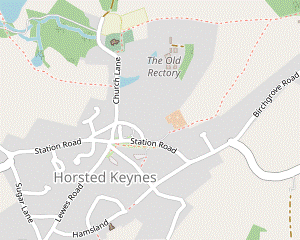
- Horsted Keynes (village) to St Giles Church (½ km)
- Head north on Church Lane to St Giles church.
- If you arrived in Horsted Keynes? by bus, go back a few paces from the stop to the junction with Lewes Road at the western end of the long village green. Take the broad tarmac path going downhill opposite the side road, joining the Sussex Border Path? (SBP) and heading N directly towards the church.
- Keep ahead at a road junction, joining Church Lane. You pass the imposing gates to the Old Rectory on your right and some attractive old cottages as the lane climbs back out of the dip. At the top of the slope go through a gap in the hedge into the churchyard of St Giles?.
- After visiting the church take the brick path past its western end up to the village school and turn left to return to Church Lane. Opposite the school driveway there is a three-way footpath signpost.
- St Giles Church to Leamland Wood Bridge (1½ km)
- From Church Lane take the footpath heading west from the school, down through a wood and round Old Mill House. Keep right to pass Mill Lake and take the first of two footpaths on the left up through a wood to Cinder Hill Lane. Turn right briefly onto the road, then take the footpath on the left alongside Leamland Wood. Before continuing the walk to the right you could detour down a track on the left for a closer look at Horsted Keynes station.
- Take the potentially muddy track heading W off Church Lane, signposted as a footpath and leaving the SBP. After going downhill through a wood for 250m it bends left to go around the garden of the picturesque Old Mill House?, with the old mill and its restored water wheel on the far side. Follow the path round to the right in front of a brick and timber barn to reach a path junction and turn right.
- The path curves gently to the right around Mill Lake? and comes to a three-way footpath signpost, with another one up ahead by a fieldgate. Turn left at the first signpost onto a woodland path, heading NW. Follow the main path uphill for 350m to emerge into a strip of grassland dotted with trees.
-
Go through this semi-open area and turn right onto a minor road (Cinder Hill Lane). In 100m, with an isolated house on the right, turn left onto a signposted footpath. Go up an earth bank and over a stile in the fence on the right to continue on a grassy strip between the fence and paddocks.
In the past it was easier to ignore the stile and stay on the narrow enclosed path, but this is becoming overgrown.
-
In 200m another stile takes you back onto the enclosed path for a further 200m alongside Leamland Wood. Continue through a metal kissing gate onto a track alongside a wire fence.
Unless you want to detour to the Bluebell Railway? station?, follow the track round to the right (or cut across the grass) to reach a small parking area.
- If you want to take a closer look at the heritage railway turn left down the track, going past the right-hand side of the visitors' car park to the station buildings. Return up the track and continue to the small parking area at the far end.
- St Giles Church to Chilling Street direct (2¼ km)
- Head north from the church on a bridleway past Broadhurst Lake and a series of fishing ponds. Go up Broadhurst Manor's driveway and turn left onto Hurstwood Lane. At a T-junction turn right and head north on Chilling Street for 250m.
- For the shorter morning route turn right onto Church Lane, signposted as a bridleway and heading N. After passing some houses keep left across a parking area to go downhill on a woodland track. In 300m you pass the attractive Broadhurst Lake? on your right, followed by a series of six fishing ponds on your left.
- At the end of the last pond fork left to go up a slope, soon with a high stone wall on your right. Turn right at a T-junction (with Garden House on the left), passing a large pond on your left. Follow the driveway round a bend to the left (with the imposing iron gates of Broadhurst Manor? off to your right) and all the way out to a lane.
- Turn left onto the lane, which goes uphill and round a bend to the right. At a T-junction turn right onto a minor road (Chilling Street), signposted to Forest Row and East Grinstead. In 250m, just before an isolated house on the left, the main route rejoins from a footpath on the left and you turn right onto the continuation of the footpath, leaving the SBP.
- Leamland Wood Bridge • Horsted Keynes Stn to Chilling Street (3 • 3½ km)
-
- If starting the walk here, go past the station buildings and all the way up a track to the left of a large field.
-
Starting from Horsted Keynes Station (+½ km)
- Go up the approach road and past the Bluebell Railway? station? (or turn left if leaving the station). Follow the track up a slope past the visitors' car park and continue to a small parking area at the far end.
- Veer left through the small parking area onto Leamland Wood Bridge, crossing over the railway. On the far side turn right onto a track curving down to the left. At the bottom follow an enclosed path round to the right and then back towards the railway, through a small plantation. Go over a stile and head N along the railway embankment for 500m, with fine views on both sides.
- The path eventually comes to a designated crossing point where you cross the track carefully. Continue alongside the railway on the left-hand edge of a field, climbing gently above the track as it goes into a cutting. At the top of the field go straight across a farm lane and over a stile onto a fenced path along the edge of a field. Continue on a faint grassy path near the right-hand side of two more fields.
- The exit from the last field takes you onto a grassy path around the bottom of a garden and then down a driveway. Cross the road (Horsted Lane) and turn left to go along a wide grass verge. In 50m go through a wooden gate in the hedge ahead into a field, joining the Sussex Border Path? (SBP).
- Follow a grassy path round to the right, passing a small brick hut on your left and with a large house (Tanyard Manor) off to your right. At the bottom go through another gate into a wood. Cross a narrow concrete dam at the head of a pond and turn left onto a path climbing through the wood. At the top turn left and go around two edges of a very large field, heading NE and then SE.
- In the bottom field corner go down into another wood, across a stream and up to another large field. Follow an enclosed path around its left-hand edge to the top corner. Go through a gate and straight across a lane (Chilling Street) onto the continuation of the footpath, leaving the SBP.
- Chilling Street to Twyford Lane (2 km)
- Take the footpath heading east across several fields to Balcombe Lane. Continue through Grinstead Wood and Twyford Farm and go along its driveway. Cut across a patch of grass and go through a small wood to Twyford Lane.
- Go over a stile to the left of a fieldgate and head E along the left-hand edge of three fields for 600m, at first alongside a low fence and later a hedge. In the fourth field follow a grassy path slightly to the left past a couple of isolated trees. On the far side go over a stile (or through a double metal fieldgate) onto a lane.
- Cross the lane and continue through a wooden kissing gate into Grinstead Wood. The stony track soon turns left to head N, with a wooded valley down on the right. In 400m follow the track down to the right (where the path ahead leads into a field). Go downhill between hedges, across a stream on a concrete bridge and then straight ahead up the other side of the valley.
-
The path comes out past the buildings of Twyford Farm and you bear right to leave on its driveway, initially heading SE. In 200m two more drives merge from the right. As the driveway swings left bear right onto a well-signposted footpath across a patch of grassland.
- There are wooden gates at each end of this short stretch, implying that the grassland is fenced off when stock are grazing there.
- After going through the gate on the far side go straight across a track (slightly to the left) onto a rather indistinct woodland path. Continue in much the same direction for about 50m to emerge onto a grassy strip and bear left to reach Twyford Lane. Turn right to go downhill on this minor road.
- Twyford Lane to Chelwood Gate (2 km)
- Go down Twyford Lane for 200m and then fork left onto a footpath through Stumblewood Common, climbing steeply on the far side. Turn left onto Birchgrove Road. Opposite Birch Grove House go onto the edge of Ashdown Forest and follow a ride parallel to the road to MacMillan Clump. For the Red Lion, head south for 250m to the A275 at Chelwood Gate.
-
Go down Twyford Lane for 200m. As the lane curves right fork left at a footpath signpost onto a tarmac driveway leading to a couple of houses. In 60m, where the drive turns sharply left, veer right onto an easily-missed woodland path.
There should be a footpath waymarker here, but it was missing when last checked.
- You will be following this footpath through the wooded Stumblewood Common for nearly 1 km. It initially heads S and then curves left, with a stream down to the right and a field visible through the trees on your left. 150m from the driveway the path crosses a side stream on a long wooden footbridge and continues near the left-hand edge of the wood.
- In 400m the path veers right to cross the main stream on another footbridge and begins a long and fairly steep ascent, with pine woods on the left beyond an ancient boundary bank. At the top keep ahead at a three-way signpost to reach Birchgrove Road in a further 150m.
- Turn left onto the road and follow it for 200m, round a bend to the right. Opposite the entrance gates to Birch Grove House? turn left onto a broad track leading into a wooded area on the edge of Ashdown Forest.
- In 40m fork right, then at the next path crossing (with a cricket pitch visible ahead) turn right onto a grassy ride heading SE. This goes across a slight dip (coming close to Birchgrove Road at a bend) and in 300m forks in front of MacMillan Clump?.
- To go to the pub, pass to the right of the trees and bear right at a junction of rides to head S. The ride comes out at the junction of Birchgrove Road with the A275, with the Red Lion on the other side of the main road.
- Chelwood Gate to Wych Cross Reservoir (1½ km)
-
From the pub return to MacMillan Clump and head north on a ride parallel to the A275. In 1 km follow the ride as it bears right and go across the A275 to a junction of rides at a corner of the covered reservoir.
- To detour to the alternative lunch pub, head north to the junction of the A22 and A275 and continue along the main road to the Roebuck Hotel at Wych Cross.
- Turn right out of the pub and go back across the main road. Retrace your steps along the ride towards MacMillan Clump and bear right in front of the trees.
-
Follow this broad ride for 1 km, which soon crosses a driveway and straightens out to head N. Ignore turnings off to a car park on the A275 on your right. Shortly before going alongside a wood on your left the ride passes Kennedy Clump? on the right.
- You might like to detour around it to see the stone memorial on the far side.
- After going alongside the wood for 250m the ride eventually swings right to meet the A275 just before Reservoir car park. Cross the road carefully and continue on the grassy ride opposite, heading E through the trees.
- In 75m you come to a major junction of rides, with a corner of the covered reservoir ahead on your left. Unless you want to visit the Roebuck Hotel (or finish the walk) in Wych Cross, turn half-right to take the second ride on your right.
-
Detour to Wych Cross (+1 km)
- Turn left at the junction onto a ride heading N. In 50m go through the car park onto a grassy track between trees. In 100m you pass Wych Cross Clump? in the trees on your right.
- In a further 125m you emerge onto a muddy patch of grass between the A275 and A22. The Roebuck Hotel is up ahead on the right-hand side of the A22, but it is safer to cross the A275 and then go up to the traffic lights to cross this very busy main road.
- To resume the walk, retrace your steps across the A22 and along the grassy track to the Reservoir. After going across the car park, turn half-left at the junction of rides near the corner of the reservoir.
- Wych Cross Reservoir to Chelwood Common (2¾ km)
- Head south-east from the junction of rides by the reservoir and continue in this direction for 750m, across Ashdown Forest. At a major junction of rides in front of a wood turn right to head south, later joining a long straight ride in the same direction. Soon after this curves right, turn left and follow a ride across a stream. Go under a brick arch to leave Ashdown Forest on a fenced path leading to a residential road at a T-junction. Go straight across and continue down Stone Quarry Road. In 600m fork right, staying on the main road.
- From the junction of rides head SE on a broad ride for 750m. You soon emerge from the trees onto open heathland (with the A22 behind a line of trees away to your left) and ignore ways off until you come to a major path junction in front of a small wood.
- At this junction take the second ride on the right, heading S. In 200m you pass a large new pond on the left and continue for a further 650m, with the ride finally curving left to come to a T-junction with a long straight ride, an old airstrip?. Turn right and follow it downhill for 400m.
- As the ride curves to the right ignore a faint grassy path on the left, but 25m later turn left onto a horse ride heading SW, downhill into trees. After crossing a stream on a wide bridge fork right up a slope. At the top go under an old stone arch on the boundary of Ashdown Forest.
- The right of way continues straight ahead, but if this footpath has become overgrown there are easier paths just off to the right. Either way, you will come out onto a residential road at a T-junction. Go straight across this to continue downhill on Stone Quarry Road.
- Go down Stone Quarry Road for 600m, forking right at the bottom to stay on the main road. 50m after this junction, the shorter afternoon route rejoins from a footpath between houses on the right.
- Chelwood Gate to Chelwood Common direct (1¼ km)
- Head south briefly on the A275, then turn left into Beaconsfield Road. Turn right into Sandy Lane and veer left onto a footpath heading south through woods and fields. After a short climb between houses turn right onto Stone Quarry Road.
- For the shorter afternoon route turn left out of the pub to go alongside the A275 for a short distance. Turn left into Beaconsfield Road, soon passing The Old Bus Garage? (with an information panel about its history) on the right. In 200m, where the road turns half-left, turn right into Sandy Lane.
- In 60m, where the lane bends right, fork left onto a driveway (with a concrete footpath marker). In a further 60m veer left at a ← FOOTPATH sign onto a grassy path through a lightly-wooded area. Keep to the right of a low garden fence and continue on a path between trees. At the end go through a wooden kissing gate into a field.
- Go diagonally across the field and leave through another kissing gate in the bottom corner. Continue on a potentially muddy path through scrubland. Later the path later dips to cross a stream, then climbs between hedges. At the top go over a stile, along a gravel driveway past a house and turn right onto Stone Quarry Road, rejoining the main route.
- Chelwood Common to Birchgrove Road (3 km)
- Head south-west on Stone Quarry Road and take the first turning on the right (Box's Lane). At the bottom of a long slope take a footpath heading south-west along the edge of a wood, then fork right to climb through it. Go through the school grounds of Cumnor House Sussex to the A275. Cross the main road to take a footpath alongside a hedge. At a T-junction turn right onto a bridleway leading into a wooded valley. At the bottom turn left onto a footpath alongside a stream. Follow this path up through fields and then past farm buildings to reach Birchgrove Road at a sharp bend.
- Go along Stone Quarry Road for 150m, then turn right at a signpost for Box's Lane. Follow this narrow lane round to the left and gently downhill for 750m. At the bottom of the slope take the second of two footpaths on the right, in effect going straight on where the lane bends left. Pass to the left of Holly Cottage and follow this muddy path downhill and across a stream on a long stretch of boardwalk.
-
At the end of the boardwalk keep ahead at a three-way signpost (where a footpath joins from the left) but 50m later fork right at another signpost to climb up the side of the wooded valley. As the path levels out it curves right and comes to a path T-junction where you turn right. Follow the path out of the wood and into the school grounds of Cumnor House Sussex?.
The right of way through the grounds has changed slightly with the construction of new buildings and a car park, but is clearly signposted.
- Go up to the corner of a car park and zig-zag right and left as indicated to continue on a roped pedestrian footway. Follow it through the car park and alongside a school building (with a clock and plaque for “Leavers 2017”). On the far side go out through a metal kissing gate in the hedge and turn left onto the grass verge alongside the A275.
- In 40m cross the main road carefully and pass to the left of a metal fieldgate into a field, with an information panel about the Birch Grove Estate. After going along the left-hand field edge for 50m a footpath signpost indicates that the right of way is a potentially overgrown path between hedges, but this rejoins the field edge further along. Either way, follow the hedge line round to the left.
- At the field boundary turn right in front of a gap in the hedge ahead to continue on a signposted bridleway, with the hedge on your left. Follow it along the edge of the field and then downhill into a wood, heading W. At the bottom of the valley you come to a path junction in front of a reed-covered pond.
- Turn left here onto a grassy track signposted as a public footpath, initially heading SW. The path bends right and later becomes less defined as it enters a semi-open area, with a stream off to the right. Ignore the first of several plank bridges across it, but maintain direction to cross the stream on a second bridge (with a footpath waymarker) and keep ahead up a slope.
- Go straight across a track to continue up the right-hand side of an open area, heading W. In 200m follow the path through a copse into the corner of a large field. Keep right to go along the field margin, then in 100m veer right and left to continue on a path in a belt of trees alongside the field. Follow this past an old barn and some large new farm sheds into a small parking area off Birchgrove Road.
- Birchgrove Road to Horsted Keynes (village) (1¼ • 1½ km)
-
 Turn right onto the road, then in 150m turn left onto the driveway to Horsted Keynes Reservoir. Veer right in front of its perimeter fence onto a path leading into the corner of a large field. For a direct route into Horsted Keynes, turn half-left through a gate and follow a footpath across fields and past allotments into the village.
-
Alternatively, carry straight on along a field edge to St Giles church and go along Church Lane into the village.
-
Alternatively, carry straight on along a field edge to St Giles church and go along Church Lane into the village.
- Turn right onto the road (briefly heading away from Horsted Keynes), taking care as there is no pavement. In 150m turn left onto a concrete driveway leading to Horsted Keynes Reservoir, going over a stile to the right of the (usually locked) main gate. In front of the perimeter fence veer right onto a path through the trees which comes out into the corner of a large field.
-
Direct route (1¼ km)
- Keep ahead briefly alongside the tree boundary, then in 40m go through a metal kissing gate on the left. Turn half-right to head SW across two fields on a faint grassy path, passing through a gate in the hedge separating them.
- In the far corner go through another metal kissing gate and continue near the left-hand edge of a third field, then past allotments and houses. Bear left onto a tarmac lane which leads to the road running through the centre of the village, with the village stores on your right.
-
Route via the church (1½ km)
- Keep ahead along the field edge all the way to the next corner, 500m away. Continue on a fenced path leading into the churchyard of St Giles?. After visiting the church, leave by its main gate and head S on Church Lane.
- The lane dips down past some attractive old cottages and near the bottom of the slope you pass the impressive gates to the Old Rectory on your left. As you climb towards the centre of the village, turn left at a crossroads to stay on Church Lane. Follow it up to the the road running through the centre of the village, with the village stores on your left.
- There is a choice of pubs for refreshment in Horsted Keynes?. The Crown Inn? is opposite the village stores and the Green Man towards the western end of the long village green.
- Horsted Keynes (village) to Horsted Keynes Station (2¼ km)
- Head north on Church Lane and turn left onto a footpath heading west along the valley floor. Keep ahead … Turn left down a track going past the Bluebell Railway station to the bus stop at the end of its approach road.
- To finish the walk at the Bluebell Railway station, make your way to the road junction at the western end of the green. Go past vehicle barriers onto the broad tarmac path descending towards the church, heading N. Keep ahead at a road junction, joining Church Lane. Just before the lane starts to climb back uphill turn left onto a signposted footpath.
- Go between houses and through a kissing gate onto a fenced path heading W along the valley floor, between a meadow and paddocks. Follow the path into a wooded area, passing a pond on the right. In 125m keep ahead across a farm track in a small dip to reach a path crossing with a four-way footpath signpost, with a lake ahead on your right. Keep ahead at this junction, heading NW.
- …
- …
-
…
At the end of the fence turn left down a track going past the right-hand side of the visitors' car park to the station buildings. The bus stop is at the far end of the station approach road.
…
- The name Horsted means ‘a place where horses are kept’. The Saxon manor was given to the Norman knight Ralf de Cahaignes by William the Conqueror. The anglicized version of his name changed over the centuries to Keynes but the pronunciation stayed as canes, not keens.
- The Sussex Border Path runs for 240 km along the length of West & East Sussex, from Thorney Island on the Hampshire border to Rye.
- St Giles, Horsted Keynes is oriented towards the midsummer sunrise instead of the usual E-W, so was probably built on the site of a pagan temple. There may have been a church here in Saxon times and it still has some Norman features. In the north wall of the chancel a small figure of a Crusader with a lion at his feet is thought to be a ‘heart shrine’. The graves of Harold MacMillan (Prime Minister 1957-63; later the Earl of Stockton) and members of his family are to the east of the church, surrounded on three sides by a hedge.
- Old Mill House was built around 1450. The old wooden mill with overshot water wheel was still being used 500 years later and remains in working order.
- Mill Lake and Broadhurst Lake were part of a series of lakes created to supply water for the local mills. They are now popular fishing ponds.
- The Bluebell Railway began operating a steam railway between Sheffield Park and Horsted Keynes in 1960, just two years after British Rail closed the line from East Grinstead to Lewes. It was extended north as far as Kingscote in 1994, and to East Grinstead in 2013 after a major project to clear a cutting of landfill waste.
- Horsted Keynes Station has been restored to the Southern Railway period in the mid-1920s. It is surprisingly large for a sleepy country station on a secondary line, some way from the village it was built to serve. There is a £3 admission charge for non-travellers when trains are running, rather more than the 1d platform ticket in 1935.
- Broadhurst Manor was rebuilt in the Tudor style in the 1920s, the original 16thC manor house having been largely destroyed by fire in the late 18thC. The TV scriptwriter Carla Lane ran her Animaline wildlife sanctuary in its grounds until she sold the house in 2009.
- Birch Grove House was the home of Harold MacMillan. The Latin inscription on the gatepost Nemo me impune lacessit (‘no one provokes me with impunity’) is the motto of the Order of the Thistle.
- Nine groups of Scots Pine trees were planted on Ashdown Forest in 1825, but their underlying purpose is not known. Wych Cross Clump (to the north of the Reservoir) is one of these original clumps; Kennedy Clump was planted in 1964 to commemorate the US President's visit to the area in June 1963; MacMillan Clump was planted in 1979.
- The old airstrip was built by Canadian Engineers during World War Ⅱ.
- The Chelwood Gate Bus Garage was used by Southdown Motor Services for nearly 40 years until its closure in 1967. It was subsequently used for a variety of purposes (including an illegal cannabis factory!) but has now been restored to reflect its period transport heritage.
- Cumnor House Sussex is an independent school for pupils aged 2 to 13, from nursery to preparatory. Its motto is “Aim High, Be Kind, Dare to be Different”.
- The Crown Inn was seriously damaged by fire after being struck by lightning in 2003, and was closed for six years.
If you are catching a bus from Haywards Heath, leave the station through its booking hall beneath the London end of the platform and bear right across the station forecourt to a road. Go past a large Waitrose and turn right at the roundabout for the 270 bus stop in Perrymount Road. Alight at the Lewes Road stop in Horsted Keynes village, near the Green Man pub.
If you are doing the shorter morning route (omitting the Bluebell Railway), go to §C.
Continue the directions at §E.
… Alight at Horsted Keynes station.
If you want to finish the walk here, buses for Haywards Heath stop outside the pub (the stop for East Grinstead is on the other side of the main road, just past the road junction).
If you are doing the shorter afternoon route (omitting Ashdown Forest), go to §I.
If you want to finish the walk here, the bus stop for Haywards Heath is between the hotel and the traffic lights, opposite the one for East Grinstead.
If you want to finish the walk here, the bus stop for Haywards Heath is at the top of this road.
Continue the directions at §J.
If you started the walk from the Bluebell Railway station the suggested route is the slightly longer one via the church in [?].
If you are finishing the walk here, the bus stop for Haywards Heath is just beyond the western end of the green, on the other side of a road junction. Buses go to East Grinstead from the stop near the Green Man.
At Haywards Heath alight at the Perrymount Road stop, just past a roundabout and opposite a large Waitrose store. Cross Perrymount Road at the roundabout and go past the store (which has a café) on your left to reach the station entrance.
This is a slightly shorter version of §A·B, bypassing St Giles church and Old Mill House.
Walk Notes
» Last updated: June 11, 2023
Return to Top | Walk Map | Walk Options | Walk Directions.