Norfolk Coast Path : Hunstanton to Cromer walk
A quiet coastal path with wide beaches, sand dunes, salt and freshwater marshes, nature reserves, barrier islands, and lots of birds.
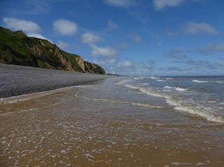
22 Cliff path between Weybourne and Sheringham
May-14 • Saturdaywalker on Flickr
book3 walkicon swcwalks walk70 14057144780
| Warning |
The suggested route follows the coastline much more than the official (high tide safe) Coast Path which often detours inland. A map and GPS route of the official route is here Since this walk was researched, the coast has been deliberately breached by the RSPB site at Tichwell. It is not clear at which states of the tide the beach route is still possible. The route description below has been updated [May 2014] to take account of cliff falls between Sherringham and Cromer. The GPS route has been updated [Nov 2014] with the new official Sherringham - Cromer route, and also, the new extension south east of Cromer, past Overstrand to Sea Palling |
|---|---|
| Length | About 45m miles. With the extenstion east to Overstrand and Mundesley: 61 miles / 98 km |
| OS Map | OS Explorers : Norfolk Coast West (250), Central (251), and East (252) |
| Toughness |
3 out of 10 - mostly level paths, or beach walking, but occasional stretches of hard going shingle |
| Features |
The North Norfolk Coast path is a national long distance trail that, as its names suggests, follows the north Norfolk Coast. The path follows a mixture of low cliffs, sand dunes, very wide sandy beaches, salt and fresh water marshes. It is great for birds and, in one place, seals. The beaches are very wide with firm sand, and the sea goes out a long way, making great beach walking. There are barrier islands that can be explored at low tide. There are a few inland sections that can be bypassed by bus, or at low tide, by following the coast. There are many small harbours, which are 'sea' at high tide, and mudflats at low tide. The eastern end of the walk is quite different - gentle cliff top paths, or coastering at low tide, and some seaside resorts. There is a regular bus service (1/2 hourly in summer) that follows the entire route, making day trips, or returning to your car very easy Given the distance, this would be a good weekend trip from London The coast path suffered in the December 2013 storm surge, but now seems back to normal. There is even a new re-routed section of the coast path at Beeston (near Cromer), and an extension south east beyond Cromer. See Griffmonster's blog for the latest news. |
| Nature and History |
|
| Links |
|
| Transport |
Coasthopper busKings Lynn (inland, station) - Hunstanton - Wells - Sherringham - Cromer (station). The great advantage of this walk is the Coasthopper bus service, 1/2 hourly in summer, which follows the entire route. It links with the rail network at Kings Lynn at the west end of the walk, and goes via Hunstanton (where the walk starts), and follows the coast to Sherringham and Cromer (both have stations) at the east end. You can easily do day walks from a base, without too much in the way of pre-planning, walk as short or as long as you like, and get the bus back to your car/hotel. Sample fares: Kings Lynn to Hunstanton: £3.70, Cromer to Wells : £3.20. A Coasthopper bus pass from Kings Lynn (inlcudes routes #10 and #11) to Hunstanton, then along the coast to Cromer, then inland to Norwich is: £9 (1 day), £18 (3 day), £32 ( 7 day). A combined 'Bitten Line' pass, including the Bitten Line train from Norwich to Sherringham, and Coasthopper bus from Sherringham to Hunstanton is also £9. Current prices online at Norfolk Green (click Fares) Coast Path Extension from Cromer to Sea PallingBus #5 : Sherringham - Cromer (station) - Overstrand - Mundesley - North Walsham (inland, station) Hourly Mon-Sat, this bus follows the coast for the coast path extension beyond Cromer as far south as Mundesley. There are rare #34 buses from North Walsham (inland, train station on Cromer line) to Mundesley, then further south to Happisburgh. A few, with awkward times for walkers, go on to Sea Palling. Consider a bus there, and walking back to. See www.sanderscoaches.com for details of these 2 buses.
London to Kings LynnThere are direct trains from London Kings Cross (1hr 35 mins). Inside the Network Railcard area. Connects with the Coasthopper bus (and routes #10, #11 which run later). About 40 mins to Hunstanton. London to Kings Lynn : Single : £23 single (Sat,Sun) £33.50 (Mon-Fri), £45 period return (1/3 off with a Network card). Advance fares, e.g. £17, only on the few direct trains from Liverpool Street. London to CromerLondon Liverpool Street to Norwich, then change on to the Bitten Line (good website) Takes about 3 hours. Outside the Network Railcard area. London to Cromer: From £9 'Advance' single (on a specified train) if booked in advance (at least the day before), otherwise £51 single or return for an 'any train' ticket [Mar-24] Greater Anglia has occasional 'Hare Fare' promotions from London to Cromer and Sherringham, as little as £15 day return By CarAbout 2 to 3 hours from London. Nice places to stop along the way are: Bury St Edmunds (historic town), Cockley Cley (NT, moated house), Blickling Hall (NT, large house and parkland, south of Cromer), and Kings Lynn (large cathedral) |
| Stay and Eat |
All the below have B&B's, with the larger towns having the bigger choice. Without a car, Wells-next-the-sea is a very good base for the coast path. "The two halves of the Coasthopper bus meet here, so you can access the whole route, and Wells is a very charming place. Its main shopping street is perhaps a bit over touristed, but the more inland parts of the town is charming. The way the harbour transforms from sand and mud flats to something like an ocean going port in the space of little more than an hour is also fascinating." With a car, try Wells, Stiffkey or Blakeney. From east to west HunstantonLarge seaside resort town. Sainsburys. Lots of everything. A 40 min bus ride from Kings Lynn train station. Old Hunstanton, to the north of the cliffs at the north end of town is a nicer place to stay, e.g. Best Western Le Strange Arms "a bit of a splurge at £70, but a very pleasant place, situated right on the edge of the dunes. The coast path runs across the bottom of its garden, and you can walk direct from its lawn onto the dunes and the beach... the pub attached to the hotel.. does nice food and from May to July or so you can enjoy sunset over the sea as you eat outside on the terrace" Holme next the seaSmall village. Pub (White Horse) ThornhamSmall village. Pubs (The Lifeboat Inn, Kings Head) Brancaster, Brancaster Staithe, and Burnham DeepdaleSmall villages strong out along a road. Pubs: The Jolly Sailors and The White Horse are recommended. The Ship Hotel has changed hands since we visited, and is now a much improved hotel / gastrobub. Burnham Deepdale has The White Horse (also a hotel), while pricey, has a nice deck overlooking the marshes to the sea, and the Deepdale Backpackers Burnham Overy StaitheSmall village, pub (The Hero), pretty quay, can walk out to Scolt Head island at low tide. HolkhamMassive sand dune backed beach with naturist area, hamlet and large country house and deer park. The Pub (The Victoria, not recommended) is about 1k, inland from the coast, the Country House is about another km inland (via waymarked path through its deer park). Entry to the Deer park is free. Wells next the seaSmall seaside resort town. Chippies, YHA, many B&B. If staying, avoid the 2 seafront pubs, head inland to either of the pubs by the village green (Crown Hotel and Globe Inn). At the time of writing, the Crown Hotel had a good value 2 course for £10 deal on Sunday-Thursday. StiffkeyHamlet, highly recommended pub (The Red Lion) MorstonHamlet, pub, picturesque NT Quay BlakeneySmall village, pretty, recommended pub (Kings Arms), small shops Cley next the seaSmall village, pretty, accomodation SalthouseSmall village, pub WeybourneSmall village, pub (Ship Inn) SherringhamMedium seaside resort town. Train Station. Steam Railways. Lots of everything CromerLarge seaside resort town. Train Station. Lots of everything A large faded grandeur, but reasonably priced, seafront hotel is the Hotel de Paris "I really liked Cromer, which at least in May was very quiet but has a wonderful Victorian grandeur about it. I stayed at the No 4 B&B in Vicarage Road, whose hyper-friendly owner pushes simply enormous breakfasts on you (I literally did not eat all day afterwards) and who has filled the house with fascinating bric-a-brac. The Red Lion (also a hotel) on the clifftop just east of the Hotel de Paris, was a good place to eat." |
| Scolt Head |
Scolt Head IslandOff the coast on day 2 of the walk, near Burnham Deepdale, is Scolt Head Island - a low sand dune covered barrier island which is a national nature reserve. The nature reserve does not usually restrict visitors as it gets so few of them (parts of the island may be closed during bird breeding season). The island is separated from the mainland by Burnham Harbour - shallow sea at hide tide, mud flats at low tide. The official coast path follows the mainland, but a more interesting route would be to follow the tidal path shown on the OS map from Burhnam Deepdale out to the western end of the island, walk across the island, then return to the mainland with a second tidal crossing at eastern end, opposite Gun Hill. Only do this if you understand the very real danger and problems of tidal paths, the least of which is that low tides are 12 hours apart! Check first locally if this is possible and safe. Burnham Deepdale Path (western end of the island): The path on the OS map was surveyed over 50 years ago, and the current path has moved since then, as it does each year in an active coastal system. Norfolk Council's "Public Rights of Way" Officer's advice [no change as of Mar-24] is only use this route if you have been shown the way by someone with local knowledge of the soft mud and tides - e.g. follow a local walking their dog. They also suggest the other alternative which is to use the seasonal ferry at high tide (which only operates for 2 hours of each 12 hour tidal period). You could also contact the Scolt Head Nature Reserve for advice. "Gun Hill crossing" (eastern end of the island) At the far eastern end of Scolt Head (opposite Gun Hill on Holklham Beach as marked on OS maps), it is possible to cross (the about 15 metre wide) channel between the island and the mainland. This crossing is possible only at absolute low tide, but you might have to wade / paddle through shallow water. It also depends on how 'low' a given tide is (it varies). At mid tide the channel would be a very dangerous 'tidal race'
In practise, the only viable way for a vistor to is for an hour or so a) at high tide from Burnham via the seasonal ferry, or b) at low tide from Gun Hill. In summer only (as the ferry is seasonal, and due to daylight) is would theoretically be possible to catch the ferry to the island at high tide, then leave at Gun Hill 12 hours later at low tide. This is maybe why the island has few visitors! |
| Blakeney Point |
Blakeney PointSat Nav: NR25 7BH (Morston Quay). Blakeney Point is a long shingle spit covered in sand dunes and a low grassy hills. It is a National Trust land, and a nature reserve. Its not quite a barrier island, as it connected to the mainland at its eastern end at 'Cley Eye'. South of the spit is Blackeny channel - shallow sea at high tide, mud flats at low tide. At certain times of the year, a seal coloney lives on the western tip of the island, at other tides, parts of it are closed in bird breeding season (the western tip - April to mid-August) There are 3 ways to the island
The best idea is either walk out-and-back from Cley Eye, or catch the ferry out, and walk to Cley Eye. Links : NT (main page), NT Blog ( Intro and articles), wikipedia. |
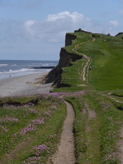
| Beeston Bump |
In Summer 2014, the coast path near Beeston Bump (between Sherringham and Cromer) was officially rerouted closer to the coast, similar to our suggested route below. The coast path used to be inland at this point. |
| Extension to Sea Palling |
In Summer 2014, a new 17 mile extension of the Coast Path opened at the east end of this walk, from Cromer south to Overstrand, Mundesley, Bacton, Happisburgh and Sea Palling See GriffMonster's blog for details, including permissive paths closer to the coast than the official route, and which beaches are tide safe. |
| Profile | |
|---|---|
| Help Us! |
After the walk, please leave a comment, it really helps. Thanks! You can also upload photos to the SWC Group on Flickr (upload your photos) and videos to Youtube. This walk's tags are: |
| By Train |
Back (not a train station) |
| By Car |
Start Hunstanton, Norfolk Map Directions Finish NR27 9EB Map Directions |
| Map Walk | This walk requires an OS map and a compass or GPS for navigation. You can print out OS maps using the link above. |
| Amazon | |
| Help |
National Rail: 03457 48 49 50 • Traveline (bus times): 0871 200 22 33 (12p/min) • TFL (London) : 0343 222 1234 |
| Version |
Mar-24 Andrew |
| Copyright | © Saturday Walkers Club. All Rights Reserved. No commercial use. No copying. No derivatives. Free with attribution for one time non-commercial use only. www.walkingclub.org.uk/site/license.shtml |


Walk Directions
These are suggested stages, you may walk further each day, or skip sections by bus. Using OS Explorer maps is recommended. You may have to get up very early or late to do certain sections at low tide. If doing day walks, you can also do then in reverse, or out of order.
Day 1 : Hunstanton - Old Hunstanton - Holme next the sea - Brancaster
9.6 miles ( 15.5 km). About 4 hours
- Hunstanton (pubs, shops, coasthopper bus) is a large old fashioned sea side resort.
- The coastal path starts in Hunstanton and follows the cliff top. At low tide, using the beach is recommended as the cliffs themselves are very photogenic, with 2 distinct layers - brown and white (chalk). The cliff top path passes a lighthouse and several cafes.
- After Old Hunstanton, the official path detours inland, but walking along the beach past the sand dunes (a national nature reserve) is nicer. Continuing along the beach after Gore Point past Holme Dine Nature Reserve may involve you crossing minor creeks - wading needed. Its easy to lose track of where you are at low tide and then have trouble finding your way back to the coast path, which turns inland before the dunes end. After the RSPB Centre at Holme Dunes (serves tea and coffee: about where the bird symbol is on the OS map) you need to turn inland towards Thornham. (The channel marked Harbour Channel on the OS Map is a permanent river - about 10 metres wide at low tide, but definitely NOT fordable - deep, with soft sand: you have to backtrack and turn inland via the coast path to Thornham (which is a pretty route anyway).
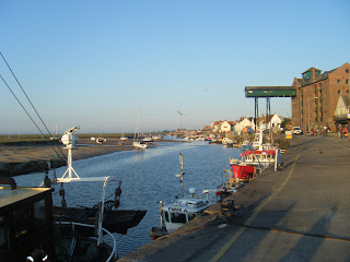
- Then its briefly inland past mudflats to Thornham (small harbour, pub, coasthhopper bus).
- Here there is a choice. The coast has been breached in front of the RSPB Titchwell to create salt water lagoons in the bird reserve. It is not clear at what state of the tide the beach is passable.
- At low tide: Head back out to the coast, past more mudflats to another wide beach, to the RSPB Titchwell Marsh Nature Reserve. Follow the beach to Brancaster (turn inland by the golf club house, the only building on this section of beach). At high tide, or if the beach ahead is closed to protect ground nesting birds, reverse your route back inland through the RSPB reserve (free, path marked on the OS map) and follow the 'official' inland route to Brancaster
- The official route detours inland at this point, and rejoins the beach route at Brancaster.
- Brancaster and Brancaster Staithe are small villages (pub, coasthopper bus).
Day 2 : Brancaster - Brancaster Overy Staithe - Burnham Deepdale - Holkham - Wells next the Sea
12.1 miles ( 19.4 km). About 5 hours depending upon route - shorten with the coasthopper bus.
- The path follows the coastal path past mudflats to Burnham Deepdale (costhopper bus, pub, backpackers).
- Here there is a choice.
- The official route goes inland, following the coastal mudflats to Burnham Overy Staithe (small harbour, pub), then follows the sea wall past mudflats out to Gun Hill and Holkham beach.
- For a description of Scolt Head, see the note above
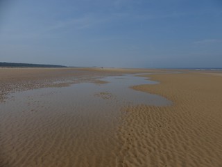
- Holkham beach is a wide beach backed by sand dunes, and regularly features in 'best UK beach' lists. The Queen sometimes walks her corgis here. It is also popular with naturists. "The far western end of the beach, as one approaches Scolt Head Island, is a fascinating and totally deserted place"
- There is a path inland to Holkham village (pub, coasthopper bus). South of the coast road is the Holkham Estate which has a large deer park with a waymarked nature trail around its lake (free) but "rather dull and uninteresting" compared to the coast. There is also an impressive country house to visit.
- Continue along Holkham beach, then turn inland along the sea wall to Wells-next-the-sea (bank, pub, shops, harbour, YHA, coasthopper bus).
Day 3 : Wells next the Sea - Stiffkey - Blakeney - Cley next the sea
9.8 miles ( 15.8 km). About 4 hours
"I found [this] stretch ... very dull, but this may be because bird life has been reduced on the marsh after the storm surge of December 2013 (so a local told me, anyway). The surge may also be why many gorse bushes on this stretch are dead. I liked the loop from Blakeney to Cley better: there were nice mating displays from oystercatchers on this stretch. Though it follows a ridge all the way, it was surprisingly easy to get lost on this stretch. Tempting paths go off into the marsh, but if you take them you come to dead ends. In the mist this would be very very confusing. I liked Cley very much - it has the most unspoiled air of any of the main stops on this coast, I thought, and is beautiful to approach from the marsh."
- After Wells, the path is inland, behind mudflats. Stiffkey, about 750m inland from the path, has an exceptional pub.
- By the campsite (marked on the OS map), there is a (low tide) path out on to the mudflats, where people have come very close to the seals that live over on Blakeney Point (NT).
- Continue along the mudflats to Morston Quay (National Trust, kiosk)
- Trips out to see seals leaves from Morsten Quay (high tide only, £8, with an hour on Blakeney Point). Note you will only see seals at certain times of the year - ask before buying your ticket!
- The NT advise you do not walk out to Blakeney Point Nature Reserve at low tide. However you get there, Blakeney Point is highly recommended, a mixture of sand dunes, and lots of birds. Once there, you can follow the coast, and rejoin the suggested route at Cley. The western tip of Blakeney Point is home to a large Seal colony, and is closed April-August (land nesting birds breeding)
- Continue past salt and fresh water marshes to Blakeney and then Cley (quay, pub, coasthopper bus)
Day 4 : Cley next the sea - Weybourne - Sherringham - Cromer - Overstrand - Cromer
13.9 miles ( 22.4 km). About 5 hours 15 mins (shorten by excluding the Overstrand loop)
"[After] Weybourne... everything changes! From Weybourne to Sheringham there are beautiful low cliffs. In May I found lots of interesting flowers here - sand specialists - as well as lots of wall brown butterflies. Swallows swooped past me constantly at ankle height, and at one point there was also a huge colony of sand martins nesting in the cliffs. It was a good place on the beach for a (very brief) dip in the sea (though the water is very brown all along this coast, which many might find off putting)."
- Continue out to the coast ('Cley Eye').
- At this point you could walk along the spit to Blakeney Point, but its about 4km of shingle at high tide (easier along the beach at low tide)
- Otherwise follows the shingle sea wall. If you were to skip 1 section, it should be this one. After Weybourne, the shingle gives way to a cliff path, and the going is easier.
- After Sherringham (large seaside town, shops, banks, pubs), you have a choice
Follow the coast to Beeston Bump (63m). Here you have a choice. - The official path turns inland over Beacon Hill (100m, view) "I also tried the official coast path which goes across fields and up onto Beacon Hill, Norfolk's highest hill apparently. There was nothing wrong with this route, but it is not exactly a coastal route and the view from Beacon Hill is very limited - distant sea over treetops."
- You can continue along the cliff top path which is suffering eroision. "You are currently fine ... until well past West Runton. Though the right of way has fallen into the sea, several caravan parks very nicely let you walk along their edge, and this is much pleasanter than it sounds. Only at Woodhill caravan park (Wood Hill on the OS map) is access denied. You are then forced inland to the main road, and you follow this (it has a pavement) for 600 metres or so until East Runton. Here ignore a path signposted to the left, which takes you to the coast but has no cliff path access. Instead, in 250 metres or so, after the second pub (the Dozy Dormouse) turn left down a road to the sea. There is still no cliff path access, but you can now walk on the beach for about 1km to Cromer, whose pier is visible in the distance. I did this at nearly high tide (at the time of a full moon) and there was still a broad strip of sand to walk on (albeit slightly soft sand, but dry soft, not wet soft)." At low tide, you can follow the beach the whole way, but beware of being cut off.
- The official path ends at Cromer, a large Victorian sea side resort with pier and train station.
Day 5 : Extending the Walk from Cromer to Overstrand, Mundesley, and on to Sea Palling
"I also did the walk to Overstrand - along the cliffs and back along the beach, which was super. If you have come up to Cromer from London in the morning, this is a great afternoon walk to introduce you to the delights ahead."
- You could continue on to Overstrand (pub, not on the coasthopper route) on the cliff path, and return along the beach path.
- Warning : If following the beach further, past Overstrand towards Mundesley, take care, as at high tide you can get cut off, and there are some groynes you have to climb over.
- See this excellent local blog for hints about the route, especially permissive paths closer to the coast, and which beaches are cut off at high tide: GriffMonster Walks