Hurst Green to Riddlesdown walk
Limpsfield Common, splendid views and remains of a medieval manor

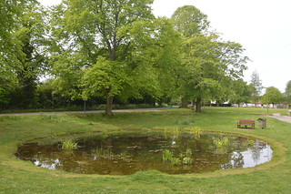
Warlingham view down to Whyteleafe Recreation Ground
May-20 • andympoole11 on Flickr
swcwalks swcwalk367 50274702611
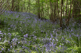
Warlingham Henley Wood enclosure with bluebells
May-20 • andympoole11 on Flickr
swcwalks swcwalk367 50274711416

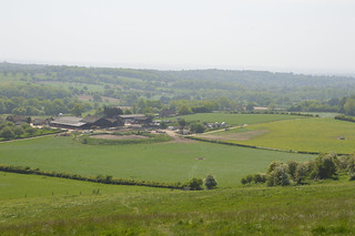
Warlingham Chelsham Court Farm cattle
May-20 • andympoole11 on Flickr
swcwalks swcwalk367 50274718491
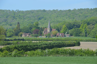
Tatsfield Clarks Lane view to High Weald and Pilgrims Farm
May-20 • andympoole11 on Flickr
swcwalks swcwalk367 50274064213
| Length |
21.6 km (13.4 miles), 5.5 hours. For the whole outing, including trains, sights and meals, allow 9 hours. |
|---|---|
| OS Map |
Landranger Map 187, Explorer Maps 146, 147 and 161. Hurst Green station, Kent TQ400514, Tatsfield TQ412568, Riddlesdown station TQ325610, Upper Warlingham station TQ341583 |
| Toughness |
5 out of 10. One short climb and a longer one up the North Downs escarpment in the morning, then in the afternoon, undulates at first before a long gentle descent (steeper if finishing at Upper Warlingham). |
| Features |
After crossing Limpsfield Common a climb up the escarpment of the North Downs provides fine views with two historic churches passed, Titsey at the bottom and Tatsfield at the top. After some undulating pasture the route passes the enclosure of a medieval manor before more fine views near the end. |
| Walk options |
The walk may be shortened by finishing at Upper Warlingham station which reduces the distance by 2.6km (1.6m). |
| Travel |
Take the train Hurst Green on the East Grinstead and Uckfield lines. On Monday to Saturday there is a hourly direct train from London Bridge Station towards Uckfield taking 31 minutes and stopping only at East Croydon and Oxted. There is also a half-hourly stopping service from Victoria Station towards East Grinstead taking 44 minutes. On Sundays it is necessary to take the Victoria to East Grinstead Service. Catch the train before 10am if catching the Victoria service or slightly later for the faster London Bridge route.Trains back are from Riddlesdown or Upper Warlingham, both with a half-hourly service and both in London Zone 6. Buy a day return to Hurst Green. It is also possible to return from Whyteleafe station which a Hurst Green ticket covers but the train times from Whyteleafe are also such that unless you have just missed an Upper Warlingham train your journey back to London will take longer. |
| Lunch |
Old Ship, Tatsfield 01959 577311 is reached after 8.6km (5.4m) having completed most of the climbing. The Old Ship is a village pub situated in one of the highest villages in Surrey atop the North Downs. It generally offers a reasonably priced tradional pub menu aiming to be attractive to walkers. |
| Tea |
Afternoon refreshments may be taken in either 2 tearooms or 2 pubs on Warlingham Green, or if finishing at Whyteleafe there is another tearoom and 2 more pubs. Of the pubs the 2 at Warlingham Green are more food orientated, whilst the 2 in Whyteleafe are drinks orientated. The only facilities near Riddlesdown station is a Village Store. At Warlingham Green:
At Whyteleafe:
|
| Profile | |
|---|---|
| Help Us! |
After the walk, please leave a comment, it really helps. Thanks! You can also upload photos to the SWC Group on Flickr (upload your photos) and videos to Youtube. This walk's tags are: |
| By Train |
Out (not a train station) Back (not a train station) |
| By Car |
Start RH8 0LL Map Directions Return to the start: Finish CR8 1HN Map Directions Travel to the start: |
| Amazon | |
| Help |
National Rail: 03457 48 49 50 • Traveline (bus times): 0871 200 22 33 (12p/min) • TFL (London) : 0343 222 1234 |
| Version |
Aug-20 Andy Poole |
| Copyright | © Saturday Walkers Club. All Rights Reserved. No commercial use. No copying. No derivatives. Free with attribution for one time non-commercial use only. www.walkingclub.org.uk/site/license.shtml |


Walk Directions
-
Hurst Green to A25 (2¾ km)
- Exit the station going sharp left through car park for 40m and then left at its end into Greenhurst Lane which soon bends to the right with a high hedge between the road and the pavement. At its end turn left into Hurstlands, pass Home Park on the right, entering Wolfs Hill and 30m later turn right along a paved footpath.
- The footpath crosses a private road (Hazelwood Heights) and goes around a school sports ground with a rustic pavilion. Beyond follow fenced path, uphill at first, to reach Pollards Wood Hill.
- Cross to pass through a gap beside a stile onto an enclosed path with a field and then open woods on the right keeping beside the wire fence on the left in the wood. Pass a deep dip being the source of the Crooked River, after which the path climbs steeply to the end of a paved access road and continues to Pains Hill in a further 300m.
- Cross into Pastens Road opposite. In 150m, just before the road bends right, pass The Oast Cottage on the left and immediately beyond go through (or around) a kissing-gate to take a footpath to Pains Hill chapel.
- Cross Chapel Road into Limpsfield Common [1] soon forking left. In 30m come to the edge of a golf course with tees on the left and when safe to cross go ½ right between trees to a green (beware balls now arriving from the right). When safe to continue go left around the back of the green for 60m until in you reach a bush that is nearer the golf than the tree line. Turn left at the bush into the wood (direction 010).
- In 45m turn left on a crossing bridleway and follow for 160m to reach the junction of Brick Kiln Lane and Stoneswood Road. Cross to the central grassy triangle then turn ½ right onto the footpath that is closest to Brick Kiln Lane.
- Continue on the path across Limpsfield Common for 400m, passing a car park on the right after 50m, and ignoring all turnings. Emerging on to a road (Kent Hatch Road), by a bus stop, cross it and turn left to cross the busy A25 70m later.
- A25 to Titsey (3¼ km)
- Turn right to pass the school then immediately ½ left on a grassy path with bushes on the left. In 40m the path bends left and in 40m more meets a gravelled path. Turn right on this away from the school. In 70m more the path meets the paved access road to a cricket club.
- This is open access land and the public footpath continues in the same direction but that involves crossing two golf fairways diagonally. It is therefore recommended to turn ½ left on the paved access road for 50m and then turn right just before the wood starts, again on a grassy path. In 50m by a tree on the right go ½ left beside the wood with golf tees ahead of you. 60m later reach the first of these tees.
- When safe to do so turn right past the tees but beware balls now coming from your right to the green you are approaching. Once over the other side go through a gap to a road (Grub Street).
- Continue ahead along the quiet lane, ignoring the track to the left and a path to the right 150m later. At the end of the lane (450m) and just before the final house is a two fingered signpost, take the right-hand option initially on a gravelled driveway and when this goes right continue ahead into a copse.
- Pass to the left of a pond to emerge from the copse into a field where you turn left on a grassy path that cuts the corner to turn right behind some new plantings protected by a barbed-wire fence 160m away, passing two horse jumps on the way.
- Continue beside and to the left of the barbed-wire fence, passing more horse jumps. In 200m, where there is a view to the left of Titsey church in the distance, go ½ right through a metal kissing-gate and through the saplings into the wood behind.
- In the wood turn left on a deeply rutted track. When this reaches a more major track, with a metal gate to the left, turn right and bend left with the track with a high wire fence on the left.
- In 300m cross an old cattle grid to reach a wide crossing track with the way ahead prevent by a rope on which hangs a ‘Private’ sign. Turn left and continue for 550m to cross the M25.
- Once across the motorway ignore a path immediately on the left (the route of the Vanguard Way) and bend left and right with the track before leaving the wood. Titsey church comes into view once more. In 230m the track crosses the, easily missed, infant River Eden [2] and continues, slowing rising, to reach a road (Pilgrim’s Way) in 500m more. Titsey church [3] is 250m along the road to the left if you wish to visit, but our way continues along the road to the right, Pilgrim’s Way an ancient trackway.
- Titsey to Tatsfield (2½ km)
- In 700m, 120m after passing Pilgrims Farmhouse and just after a right-hand bend, turn left over an ivy covered stile hidden in the hedgerow into a field that can be muddy. Continue uphill heading for a stile at the top of the field and 30m in from the left-hand hedge and then steeply up to a gap in the trees, slightly to the right. Just before entering trees at the top, briefly join the North Downs Way, and be sure to turn around for the view [4].
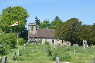
- At the top arrive at a road junction and cross, with care, to take Church Hill the leftmost of the two minor rounds opposite. In 50m take a set of steps to the left of the road leading to Tatsfield church [5] entering through a lych-gate. Pass to the right of the church, exiting by another lych-gate turning left on to the road.
- In 150m, where the road bends right and a farm gate is set back on the left, continue straight ahead through a high hedge with the remains of a stile onto another golf course. Once through the gap continue ½ right past a line of conifers and through a second tree line to a marker post 70m away on the edge of a fairway.
- Continue, as indicated, in the same direction across the fairway, watchful of golf balls, to go through a gap in a line of conifers on the far side. Turn left on a sandy path between conifers until you can go right through a gap in the second line of them to reach a shoulder high fence with a horse paddock behind.
- Turn left between the conifers and fence and follow the fence around several corners, ignoring any gaps in the conifers leading back to the golf course. Eventually the path descends between fences.
- At the bottom continue through a kissing-gate and climb up the other side going through an ordinary metal gate and two more kissing-gates to come to a road (Ship Hill) on the outskirts of Tatsfield. Turn left and 60m later by a bus stop bear right for 30m for the Old Ship facing the village green and pond.
- Tatsfield to Chelsham Court Road (3 km)
- After lunch continue across the green to the right of the pond and passing the village store on your right. Beyond the pond the green opens out to the right and a paved path goes ½ right across it passing a playground and exercise equipment, both on the right.
- At the far end turn right onto Lusted Hall Lane just before in bends left. Go left with the road and in 130m pass Gresham Close on the left. 13m later go through a gap on the left up a bank and beside a large tree. Once through the gap turn right to follow the road with the hedge between.
- In 110m, where there is again access to the road on the right, bear slightly left with a hedge on the right for 500m through 2 fields going downhill in the second. At the bottom continue up a lightly wooded area to find a stile into a field. Continue ahead crossing the field diagonally to the far corner where a gap leads to a road (Beddlestead Lane).
- Turn right on the road for 270m after which turn left on a signed path through a wooden gate opposite the second house on the right, then turn ½ right to another stile 120m away. Continue ahead along the fenced track for only 50m, then go ½ left through two metal gates. After going through the second gate bear right to follow the fence on the right for 100m to a stile in the corner which you cross.
- Continue downhill to a stile in the bottom of the valley which is just left of a field gate and to the right of a single tree. Continue in the same direction over another ridge aiming for the line of trees coming down from the hill behind (direction 300). On the far side at the bottom, pass a disused stile and then cross one 10m later to follow an uphill path through woodland, ignoring a path to the left when ½ way up, to reach a road (Chelsham Court Road).
- Chelsham Court Road to Farleigh Road (3½ km)
- Turn left on the road for 200m passing Chelsham Court Farm to a road junction where turn right into Washpond Lane and in 40m find a stile on the left leading into a field. Cross the field diagonally to cross 4 more stiles, the third being in a dip. Once over the fourth stile turn left from your original direction to the end of the fence on the left-hand side of the field which marks the track you are about to join. Cross the final stile going ½ right onto the track at the edge of a strip of wood.
- In 15m ignore a crossing bridleway and continue ahead on the track that leaves the wood and splits (take either) to lead to a road (Ledgers Road) in 270m. Turn right on the road and 60m later turn left on a wide track protected by a metal barrier and 50m later bear left on a fenced track between fields.
- In 450m, 30m after a Henley Wood starts on the left, ignore a signposted footpath on the left into the wood. At this point the bank and ditch of a medieval manor house [6] first becomes noticeable just inside the wood. 230m later turn left on a signposted path, wide at first, and here the bank and ditch is most visible. 100m later ignore a path that merges in from the right and goes off left through the raised bank, continuing ahead.
- In 80m a marker post directs you ½ right (with a left ‘Private’ sign to the left) leaving the bank and ditch behind. 150m later ignore a path on the right towards a stile leading out of the wood and continue 5m to a more major junction. Turn right on a wooded strip between fields and follow this for 350m to a crossing bridleway with housing a little off to the right.
- Turn left on the bridleway and immediately right on a footpath into dense woods. The path bends left then at each following junction bear right, exiting the wood onto a road at the bottom of a slight dip.
- Now you can either follow the unsurfaced road ahead (Greenhill Lane) or walk through the large field to the right of it. To do the latter turn right uphill for 30m and just past a large tree in the hedge there is a gap where you can cross a two wired fence into the field and pick up a Permissive Horse Ride. Continue along the track or bottom of the field for 500m where a gap near the field corner returns you to Greenhill Lane.
- At the end of Greenhill Lane turn right into Sunny Bank and 50m later at a mini-roundabout left into Farleigh Road.
- Farleigh Road to Tithepit Shaw Lane (2¾ km or 2¼ km)
- 25m later fork right on a bridleway slowly climbing for 500m passing several sets of high wooden posts until a track comes in from the right.
- There are then two options:
- If you wish to go via Warlingham Green for refreshments then turn left through a kissing-gate and a barrier to pass between paddocks. A further kissing-gate leads to the edge of a small wood with a bank up to the right. At the end continue ahead on the left-hand side of a field on a track that becomes Mint Walk. At the end turn right to pass the Horseshoe and White Lion pubs with Coffee at 412 across the pedestrian crossing and Flavours Coffee Bar a couple of doors further on the right. To continue follow the Green round to the right and cross to Ye Olde Leather Bottle which is now a tapas restaurant. Turn right then immediately left into Shelton Avenue, which forms a square. Go either way round two sides to exit into Shelton Close in the far corner (not Shelton Court). At the end where a gate leads to a sports ground go to its right on an enclosed footpath with the sports ground on the left. At the end the path continues with a field to the left and another sports ground, followed by trees on the right. Eventually come to a crossing gravelled bridleway with a stile opposite. Cross the stile.
- Alternatively you can take a short cut missing Warlingham Green. Continue ahead, slightly left, on the track. In 160m, with a graveyard visible beyond a gate, follow the track around to the right and in another 300m shortly after it becomes paved continue ahead, ignoring a road to the left, to a main road (Limpsfield Road). If needed a bus to Croydon can be caught to the right on the opposite side. Cross the road to continue opposite along a gravelled bridleway for 200m to a crossing path where turn right over a stile.
- Both Routes – Once over the stile cross the field to another stile in the middle of the far hedge to enter a rugby field. The Right of Way continues around the field to the left, but if no game is going on you can cut the corner by going to the left of some open white fencing to an obvious dark hole just to the right of the far left corner, the direction being a continuation of that in the previous field.
- Continue in the dense wood until reaching a gravelled driveway in 50m where turn left passing a row of three cottages. The driveway passes a large hut on the right then widens and goes past a low lifting barrier, coming to another busy road (Tithepit Shaw Lane).
You now have a choice of finishing in either Riddlesdown or Upper Warlingham
Finish at Riddlesdown
-
Tithepit Shaw Lane to Riddlesdown station (3¾ km)
- To continue the main walk cross the road and walk along the footpath/minor road opposite and after 70m turn right across grass following a high wire fence on the right. When the fence goes right follow it on an enclosed path. In another 200m, just before the path enters a field, go through a gap in the hedgerow on the left.
- Once through the gap go slightly left cutting a field corner to the hedgerow opposite and follow it around to the right. 150m later the hedgerow on the left ends and you go ½ left for 150m to a gap in the hedgerow leading to the large open space of Riddlesdown.
- Continue ahead past green metal fencing protecting a quarry and at its end go slightly left then right to continue at the top of the slope, the view [7] opening out.
- In 400m go through a hedgerow gap. Cross the next field, going slightly left, to another gap in 200m, still at the top of the slope. In the following field go ½ left diagonally downhill towards a kissing-gate in the middle of the hedgerow at the bottom with a notice board.
- Do not go through the kissing-gate but turn ½ right along the bottom of the field, on a level path entering woodland after 50m. In 75m ignore an uphill path on the right and 10m later emerge from the wood at a kissing-gate.
- Once through the gate turn right and the path soon splits, you can take either the grassy path beside gardens or go ½ left to join the track below (Riddlesdown Road). In 120m both the grassy path and the track go through gaps in a hedgerow. Ignore all gates on the right.
- In 250m the grassy path merges with the track on which continue for 300m to a car park. Beyond the car park follow its access road to exit the common through a gate beside the road and continue down Riddlesdown Road for 150m to a main road (Mitchley Avenue).
- Cross at the bollards and turn right passing, on the left, Coombe Wood Hill and a brick wall with the railway beyond. 150m beyond Coombe Wood Hill and 25m past the railway turn left, as signed, on a paved path down to Riddlesdown station.
- In 220m, and 20m before the southbound platform entrance a path to the right leads to the Village Store. If not wanting this continue ahead to the road at the bottom. Whichever you take the London bound platform is reached by crossing beneath the railway and turning left.
Finish at Upper Warlingham
-
Tithepit Shaw Lane to Upper Warlingham station (1¾ km)
- For the shorter walk continue along the footpath/minor road opposite and after 60m turn left into another road with a ‘Private Road’ notice and 10m later fork left on a fenced path*. In 200m the path enters a field where bear right with brambles on the right, and in another 50m come to a crossing path, turn right on it, downhill.
- The path goes through some light woodland then descends more steeply and becomes stepped, with good views [7]. At the bottom continue ahead, just to the right of some tennis courts, passing Pavilion Cafe to a car park in the far corner with nearby toilets. At the road beyond turn right and cross beneath the railway.
- If you want to go directly to Upper Warlingham station turn immediately left uphill. If wanting to call in one of the two pubs first then continue down to the A22 roundabout and turn left. The Whyteleafe Tavern being opposite, while turn right for the Radius Arms which is a little further to the left between the pedestrian lights and the bus stop. After suitable refreshment continue along the A22 to take the first left Station Road, with a fish and chip shop on the corner, to reach the station.
References
- Limpsfield Common was once primarily heathland with commoners grazing their animals as far back as the 14th century, and prior to that as a stone quarry, according to the Doomsday Book. Nowadays looked after by the National Trust there is little grazing and the woodland has encroached.
- The route crosses the infant River Eden about ½ km from its source which continues to flow through Edenbridge and Hever to join the Medway near Penshurst.
- The first mention of a manor at Titsey dates to 962 in the reign of Edgar the Peaceful and the first mention of a church in 1237 and until the current church was built was located in Titsey Place. The current Church of St James was built in 1775-6 although many tomb-slabs, including those of the Gresham family, were transferred from the old church.
- The view from the top of the North Downs is mostly of Oxted and the High Weald but stretches all the way to the South Downs.
- Tatsfield Manor was referenced in the Doomsday Book as ‘held by Anschitell de Ros of Bishop Odo of Bayeaux’ who was a half-brother to William the Conqueror. The foundations of the manor lie in the field of Church Farm, while the nave of St Mary’s Church is believed to date from about this time.
- Henley Wood Enclosure is the remains of a medieval manor house with various finds including worked flints, roofing tiles, an iron chisel, knife blade and ox-shoe together. The pottery finds mostly date from late 12th century to early 14th although some pottery is much older, possibly 6th or 7th century. These finds are kept at the East Surrey Museum near Caterham Station. It is likely that this is the second Chelsham Court Manor mentioned in the Doomsday Book.
- Both the finishes have good views across the Caterham Valley towards Kenley on the main route and towards Caterham on the Hill on the alternative finish.