Ingatestone to Battlesbridge walk
The Wid Valley and the Wid itself, Hanningfield Reservoir Nature Reserve and the Crouch Valley via a mix of woods and fields.
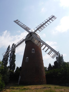
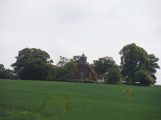
Stock Tower Mill
SWC Walk 158 - Ingatestone to Battlesbridge or Wickford
May-18 • thomasgrabow on Flickr
swcwalks swcwalk158 banner 42653157621
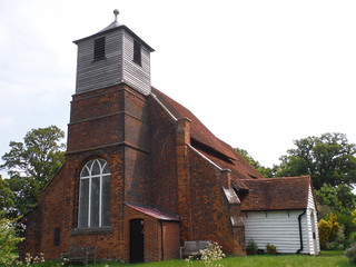
St. Mary's Church, Buttsbury
SWC Walk 158 - Ingatestone to Battlesbridge or Wickford
May-18 • thomasgrabow on Flickr
swcwalks swcwalk158 walkicon 42653267981
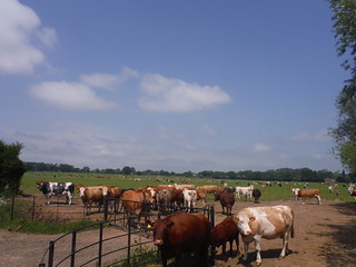
Large Field, Large Cattle Herd (Fristling Hall)
SWC Walk 158 - Ingatestone to Battlesbridge or Wickford
May-18 • thomasgrabow on Flickr
swcwalks swcwalk158 walkicon 41935778934

Horses in Wildflower Meadow
SWC Walk 158 - Ingatestone to Battlesbridge or Wickford
May-18 • thomasgrabow on Flickr
swcwalks swcwalk158 walkicon 41753444225

Ingatestone Hall
SWC Walk 158 - Ingatestone to Battlesbridge or Wickford
May-18 • thomasgrabow on Flickr
swcwalks swcwalk158 41935901624
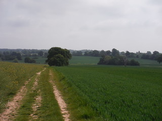
Into the Wid Valley
SWC Walk 158 - Ingatestone to Battlesbridge or Wickford
May-18 • thomasgrabow on Flickr
swcwalks swcwalk158 42653303421
St. Mary's Church, Buttsbury, across a field
SWC Walk 158 - Ingatestone to Battlesbridge or Wickford
May-18 • thomasgrabow on Flickr
swcwalks swcwalk158 41935822174
| Length |
24.8 km (15.4 mi), with 180/228m ascent/descent. For a shorter walk see below Walk Options. |
|---|---|
| Toughness | 4 out of 10, with 5 hours 20 minutes walking time. For the whole outing, including trains, sights and meals, allow at least 8 hours. |
| Walk Notes |
This rewarding Essex walk avoids major roads and all remnants of industry and suburbia to initially traverse through fields in the Wid Valley and follow the Wid itself for a while, while passing through the Fristling Hall estate, one of the largest – but quite scenic – cattle farms in the country (with sturdy black metal fences separating humans from beasts), before proceeding through a delightful wood to lunch in Stock.
Notes: In high summer, the fenced paths through the Fristling Hall Estate and some others towards the end of the walk can be encroached by nettles and brambles. After rain, the 1.2 kilometres of arable field crossings near the end (along clear paths) will be challenging. |
| Walk Options |
Morning Shortcut (cuts 3.5 km): avoids the fenced paths along the Wid River and the tracks through the Fristling Hall estate to ascend along a choice of two routes into Stock (one using tracks and lanes, the other field boundaries and a field crossing).
|
| Maps | OS Landranger: 167 (Chelmsford) and 168 (Colchester) and 178 (Thames Estuary)
OS Explorer: 183 (Chelmsford & The Rodings) and 175 (Southend-on-Sea & Basildon) |
| Travel | Ingatestone Station, map reference TQ 649991, is 9 km south west of Chelmsford and 55m above sea level. Battlesbridge Station, map reference TQ 776948, is 13 km south east of Ingatestone and 8m above sea level. Wickford Station, map reference TQ 744936, is 11 km south east of Ingatestone and 13m above sea level. All three are in Essex. Ingatestone is on the Great Eastern Main Line from Liverpool Street to Norwich (half-hourly service, hourly on Sundays), with a journey time of 27 or 28 minutes. Battlesbridge is on the single-track Crouch Valley branch line from Wickford to Southminster, which has at least one train an hour Monday to Friday, one every 40 minutes Saturday, and hourly trains on Sunday (journey time from 47 to 58 minutes). Saturday Walkers’ Club: Take the train closest to 10.15 hours if intending to eat in Stock, 1/3 into the full walk; or the train closest to 9.15 hours if intending to eat in South Hanningfield 2/3 into the full walk. |
| Lunch |
The Bakers Arms Common Road, Stock, Essex, CM4 9NF (01277 840 423). The Bakers Arms is located 8.9 km (5.5 mi) into the walk.
|
| Tea |
Several options on both the Battlesbridge and Wickford Endings. For details see the pdf. |
| Profile | |
|---|---|
| Help Us! |
After the walk, please leave a comment, it really helps. Thanks! You can also upload photos to the SWC Group on Flickr (upload your photos) and videos to Youtube. This walk's tags are: |
| By Train |
Out (not a train station) Back (not a train station) |
| By Car |
Start CM4 0BW Map Directions Return to the start: Finish SS11 7RG Map Directions Travel to the start: |
| Amazon | |
| Help |
National Rail: 03457 48 49 50 • Traveline (bus times): 0871 200 22 33 (12p/min) • TFL (London) : 0343 222 1234 |
| Version |
Apr-24 Thomas G |
| Copyright | © Saturday Walkers Club. All Rights Reserved. No commercial use. No copying. No derivatives. Free with attribution for one time non-commercial use only. www.walkingclub.org.uk/site/license.shtml |


Walk Directions
Full directions for this walk are in a PDF file (link above) which you can print, or download on to a Kindle, tablet, or smartphone.
This is just the introduction. This walk's detailed directions are in a PDF available from wwww.walkingclub.org.uk