Kenley to Caterham walk
Short but hilly walk on the slopes of the North Downs.
| Length |
Main Walk: 14¼ km (8.9 miles). Three hours 40 minutes walking time. For the whole excursion including trains, sights and meals, allow at least 7½ hours. Short Walk, omitting Woldingham: 12 km (7.5 miles). Three hours walking time. |
|---|---|
| OS Maps |
Explorers 146 & 161. Kenley station, map reference TQ324601, is in south London, 5 km S of Croydon; Caterham is in Surrey. |
| Toughness |
5 out of 10 (4 for the Short Walk). |
| Features |
This North Downs walk makes use of a branch line which winds its way up a dry valley to Caterham. Starting from Kenley station, the walk climbs onto Riddlesdown and goes through a series of meadows in the Sanderstead to Whyteleafe Countryside Area. It continues through the full length of King's Wood, the best of several bluebell woods in the area. More footpaths, alleyways and back streets lead into the centre of Warlingham, with a choice of pubs for lunch. The afternoon leg is distinctly tougher as the walk has to cross three valleys in this undulating countryside. It starts through the green oasis of Blanchman's Farm Nature Reserve, then curves gently downhill around Halliloo valley. A steady climb via the unusual settlement of Woldingham Garden Village (which retains traces of its wartime history) and a picturesque hillside walk leads to the hilltop village of Woldingham. Two more steep-sided valleys have to be crossed before the walk descends into the town of Caterham, at the end of the branch line. |
| Walk Options |
The Short Walk cuts out the biggest of the three afternoon climbs by taking a direct route through Marden Park valley, bypassing Woldingham. Both of the afternoon routes cross the Oxted railway line near Woldingham station, allowing you to cut the walk short and finish there (but see Transport below). |
| Transport |
Kenley is the first station on the Caterham branch line, with a half-hourly semi-fast Southern service from London Bridge taking 32 minutes (although a much slower service is often substituted during engineering works, when it is better to change at East Croydon). All the stations on this line are in TfL Zone 6, so you can buy a Travelcard or use Oyster PAYG. If you want to abandon the walk at lunchtime London bus 403 runs every 12-20 minutes through Warlingham to Croydon, and Southdown 409 (not TfL) runs hourly down to the stations in Whyteleafe; this has two stations on the same branch line as well as Upper Warlingham on the Oxted line. Woldingham station (near the afternoon routes) is also on the Oxted line but outside the TfL area, so if you finish there you would need to buy a single to Upper Warlingham (on the Zone 6 boundary) to supplement a Travelcard or London Freedom Pass. If driving, the small station car park at Kenley costs £5.70 Mon–Fri, £2.40 Sat–Sun (2023). On-street parking is likely to be difficult on weekdays. London bus 407 is an alternative way of returning to your car, running every 10-20 minutes between Caterham, Whyteleafe and Kenley. |
| Suggested Train |
Take the train nearest to 10:45 from London Bridge to Kenley. |
| Train Times |
|
| Timetables |
|
| Lunch |
There are two chain pubs next to each other in Farleigh Road, just off Warlingham Green after around 6½ km. The Horseshoe is a Barons pub / restaurant with a large oudoor seating area at the front; the White Lion (01883-625085) is an Ember Inns pub in a historic building, with a back garden. Both have large menus and serve classic pub food. There are several cafés and restaurants around the green, including Coffee at 412 (01883-622833) and Flavours Coffee Bar (01883-625777; closed Sun). |
| Tea |
There are several tea options in Caterham. There is a Caffè Nero (01883-342464; open to 5.30pm) at the top of Timber Hill Road and a Costa (0333-0035883; open to 7pm Mon–Fri, 6pm Sat, 5pm Sun) in the parade of shops opposite the station. There is also The William Garland pub (01883-343267) and some independent cafés (eg. Caffe Bambino at #24 Croydon Road) in the main street, although the cafés tend to close earlier than the chain coffee shops. |
| Profile | |
|---|---|
| Help Us! |
After the walk, please leave a comment, it really helps. Thanks! You can also upload photos to the SWC Group on Flickr (upload your photos) and videos to Youtube. This walk's tags are: |
| By Train |
Out (not a train station) Back (not a train station) |
| By Car |
Start CR8 5DF Map Directions Return to the start: Finish CR3 6LB Map Directions Travel to the start: |
| Amazon | |
| Help |
National Rail: 03457 48 49 50 • Traveline (bus times): 0871 200 22 33 (12p/min) • TFL (London) : 0343 222 1234 |
| Version |
Nov-23 Sean |
| Copyright | © Saturday Walkers Club. All Rights Reserved. No commercial use. No copying. No derivatives. Free with attribution for one time non-commercial use only. www.walkingclub.org.uk/site/license.shtml |


Walk Directions
Click the heading below to show/hide the walk route for the selected option(s).
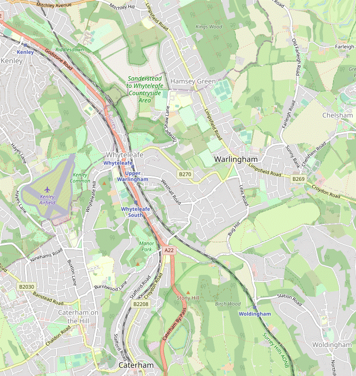


 Walk Map
©
Walk Options
Click on any option to show only the sections making up that route, or the heading above to show all sections.
- Main Walk (14¼ km)
Walk Directions
Click on any section heading to switch between detailed directions and an outline, or the heading above to switch all sections.
- Kenley Station to the Sanderstead to Whyteleafe Countryside Area (1 km)
- Go down Station Approach to the A22 (Godstone Road). Cross over and take the footpath to the right of the old quarry slanting up the side of Riddlesdown. At the top bear right onto a track (Riddlesdown Road), then veer left through a gate into the Sanderstead to Whyteleafe Countryside Area (SWCA).
- Arriving from London, do not cross the footbridge but leave through a gap near the London end of the platform. Go out through the small car park and down Station Approach to the A22 (Godstone Road), with a supermarket and the (closed) Kenley Hotel in the parade of shops on the right.
- Cross the main road carefully at the traffic island, go up a flight of steps and through a wooden gate onto Riddlesdown?, with an old chalk pit? on the left. Follow the chalky path sloping up the hillside, with a fenced-off wood on your left. In 250m the path merges with another one coming up from the A22 and curves left into a more open area.
- Any route sloping up the hillside will eventually emerge onto a broad strip of grassland with a stony track running along it (shown on maps as Riddlesdown Road as it was used by vehicles until the 1970s). For the most direct route bear right across the grass and go through a wooden gate. Fork left, go through another gate and continue climbing, ignoring a path on the right alongside a wire fence.
- The grassy path gradually approaches the track and joins it just before a gap in the hedge ahead. Go through this and bear left onto a chalky path to stay near the top of the grassland for 250m. Ignore the first gate into the woodland on your left but veer left through the second gate into the bottom of a small meadow, entering the Sanderstead to Whyteleafe Countryside Area? (SWCA).
- The SWCA to King's Wood (2½ km)
- Make your way through Woodpecker Fields, Long Acres and 20 Acres to the southern end of Ansley Berry Shaw. Veer left around this wood, then go diagonally across another meadow (Marles) to an exit in the northernmost part of the SWCA. Join a footpath leading out to the B269 (Limpsfield Road). Cross over and go along Sanderstead Court Avenue and Lime Meadow Avenue. At the far end turn right into King's Wood.
- Take a clear grassy path slanting up across the meadow to its top right-hand corner. Go through a gap in the trees and fork left to stay near the edge of the next meadow. Go straight across a track and through a wide belt of trees into the corner of a large meadow (Long Acres).
- Bear right onto a clear grassy path across the meadow, heading E towards a point roughly two-thirds of the way along its right-hand side. Go through a gap in the tree boundary there into another meadow (20 Acres) and keep ahead to pick up a grassy path going towards its far left-hand corner, gradually approaching a wood on the left (Ansley Berry Shaw).
- Go through the tree boundary and turn left along the edge of the next meadow (Ibetts Field). In the corner go through a gap in the trees and continue alongside the wood. In 125m turn left through a wide gap and follow a clear grassy path diagonally across the last meadow (Marles).
- In the far corner leave the SWCA through a wooden gate and go along a woodland path. In 250m keep right to continue on a narrow path between the chainlink fence around a school playing field and garden fences. The path turns right and goes out alongside the school's entrance drive to the B269 (Limpsfield Road).
- Turn left, cross the road at the pedestrian lights, and turn right into Sanderstead Court Avenue. At the bottom of the slope fork right into Lime Meadow Avenue and follow this residential street up and round to the left. Where it ends at the entrance to a sports ground, turn right onto a short path leading to the north-western corner of King's Wood?.
- Through King's Wood to Kingswood Lane (1¼ • 1½ km)
-
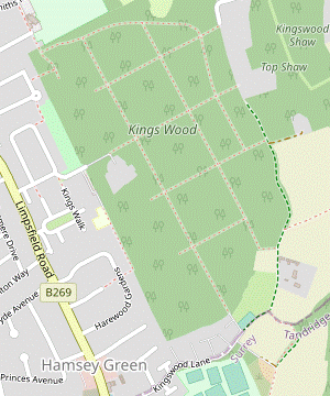 For a straightforward route turn left inside the wood to come to the main central ride and turn right to go all the way along it to Kingswood Lane.
- For a more intricate alternative route you could start by going straight ahead and then make your way along minor paths to a major path crossing in the centre of the wood. Cross over the main ride, then turn right onto a minor path past a wildlife pond. Continue on minor paths parallel to the main ride before returning to it near the exit.
-
Main route (1¼ km)
- Inside the wood turn left, then in 50m fork right where the path splits. In 100m bear right onto the long main ride running SSE through the centre of the wood, with major path crossings every 200m.
- At the second of these path crossings there is an information panel and a minor path also joins from the right. At this crossover point you could switch to the alternative route at [?·c] below.
- To complete this section on the main route simply follow the main ride heading SSE all the way through the wood, with a fenced-off area on your left for the final 125m. Skirt around a vehicle barrier and continue past a horse training area to an unsurfaced road (Kingswood Lane).
-
Alternative route (1½ km)
- Inside the wood start by going straight ahead. For the next 500m keep ahead at path crossings but fork left wherever the path splits (in effect avoiding side paths and staying on the ‘main’ path).
- This rule of thumb should have you heading roughly SE. With luck you will come to a major path crossing with an information panel in the centre of the wood, where you could switch to the main route at [?·c] above.
- To complete this section on the alternative route take the ride heading ENE at the path crossing. In 100m turn right onto a side path, heading SSE.
- In about 100m the path swings left and right to skirt around a small wildlife pond. In a similar distance go straight across another of the main rides to continue in much the same direction.
- In 200m keep ahead across another ride. Where the path comes to an area with badger setts and no clear ‘main’ path ahead, bear right to head back towards the main central ride.
-
Join the main ride heading SSE,
…
- Kingswood Lane to Warlingham Green (1¾ km)
- From Kingswood Lane take the driveway leading to Kingsmead Equestrian Centre. At the back of the stables turn right onto a footpath leading to Hamsey Green Recreation Ground. Make your way to the opposite corner and continue along an alleyway to Crewe's Lane. Keep ahead along Ward Lane, Church Lane and a footpath to a small recreation ground. Bear right across it and go along Mint Walk to Farleigh Road, with two pubs and Warlingham Green just off to the right.
- Turn right briefly onto the lane, then in 30m turn left into the access road for Kingsmead Equestrian Centre, a private drive signposted as a public bridleway. In 100m continue on a path to the left of a small parking area. Go past the side of the stables and keep right at a three-way footpath signpost.
- Follow a narrow enclosed path past the back of the stables, with a large field on the left and later a sports ground on the right. In 250m this potentially muddy path leads into the corner of Hamsey Green Recreation Ground. The right of way is the tree-lined path on the right going around two sides of the ground, but if there is no activity you could cut across the grass.
- In the opposite corner the perimeter path leads into a paved alleyway. Go straight across one street and turn left into the second (Crewe's Lane). Follow this round to the right, where it becomes Ward Lane. Go past the parish church of All Saints? to continue on Church Lane. After passing the entrance to a sports ground this becomes a private road but is signposted as a public footpath.
- At the end of this cul-de-sac keep left to continue on an enclosed path. Veer left into a small recreation ground and bear right to go across it to a track on the far side. Turn right onto the track, which leads into a tarmac lane (Mint Walk). Follow this out to a T-junction with Farleigh Road, with Warlingham Village Hall beyond it on the B269 (Limpsfield Road).
- The two possible lunch pubs are the first two buildings on the right, The Horseshoe and the White Lion. There are some other eateries in the cluster of shops around the main village green a little further along, including Coffee at 412 on the left and Fountains coffee shop on the right.
- Warlingham Green to Halliloo Valley Road (1¾ km)
- From the green take the B269 (Limpsfield Road) heading south-east. Opposite Bond Road turn right into Blanchmans Farm and follow a path through this small nature reserve to an exit at the top of a road (Bug Hill). Take a footpath on the left of this road curving down the side of Halliloo valley, parallel to the road. At the bottom go past a crossroads and continue alongside Halliloo Valley Road to a footpath junction opposite Park Ley Road.
- Make your way onto the main road heading SE away from the green (from the pubs, cross the side road and turn left onto the B269). 250m beyond the Village Hall, and opposite the Recycling Centre on Bond Road, turn right into Blanchman's Farm Nature Reserve?.
- Follow the track into the corner of a field and continue along its right-hand edge, heading S. At the end of the houses on the right ignore a path into the trees, but 50m later fork right to go around a small pond. In 75m fork left onto a path heading SW, initially alongside a copse and then as a fenced grassy path between fields. At the far end go through the tree boundary and across a driveway onto a minor road (Bug Hill).
- Turn left briefly onto the road, taking care as there is no pavement. Just past the junction with Tydcombe Road take the signposted footpath on the left going downhill, staying fairly close to the road. In 100m keep ahead at a footpath junction, ignoring a path going steeply down to the left.
-
In 75m the path comes out of the trees into an open area above a golf course, with a footpath signpost indicating two rights of way ahead. Fork right and follow a rather awkward path across the top of the grassland, staying fairly close to the trees on the right.
- The left-hand footpath is a more direct route to Halliloo Valley Road, but there is no clear path on the ground and the right of way crosses several golf fairways.
- On the recommended route the path curves gently downhill around the end of Halliloo valley, mostly in the open but with a few short stretches through the tree boundary (and at one point along the edge of a golf tee). In 450m the path merges with a bridleway coming in from the road on the right (Bug Hill again) and continues alongside the road for a further 150m.
- At the bottom of the valley ignore a way out by a road junction and follow the bridleway round to the left, now climbing gently alongside Halliloo Valley Road. In 125m turn right at a footpath signpost and cross the road with great care. There are two possible continuations, both public bridleways: a driveway to several houses going up to the left, and Park Ley Road straight ahead.
- Halliloo Valley Road to Woldingham (Long Hill) (1¾ km)
-
Take the bridleway to the left of Park Ley Road, up to Woldingham Garden Village. For the main route, go around two sides of this settlement on Hilltop Walk and turn right onto a footpath which continues (as Madeira Walk) along the hillside to a lane (Long Hill).
- Alternatively, stay on the bridleway. This skirts the Garden Village and takes a slightly lower route along the hillside. At the end turn left onto Long Hill to rejoin the main route.
- For the Main Walk take the driveway to the left of Park Ley Road, climbing steadily. In 350m it comes to a tarmac lane on the outside of a bend, with the bridleway continuing straight ahead past the right-hand side of the house opposite.
-
Main route
- Turn left onto the lane, which curves right uphill into Woldingham Garden Village?. In 75m fork right into Hilltop Walk, still climbing. Eventually the lane levels out and turns left in front of the Peace Centre? village hall.
- Carry on along Hilltop Walk, past a row of houses. At the end ignore a driveway off to the right but 10m further on turn right into an easily-missed narrow footpath between garden fences.
- The path continues down a few steps in a patch of woodland and comes to a footpath waymarker by a plaque for Madeira Walk?. There is a bridleway signpost down to the right, where you could switch to the alternative route at [?·c] below.
- To complete this section on the main route take the waymarked footpath, parallel to and slightly above the bridleway. As it goes along the side of Long Hill there are soon fine views across to Marden Park valley, with a bench to pause and enjoy them near an information panel about the chalk grassland habitat.
- The path goes back into a wooded area and continues on a potentially muddy stretch past the garden fences of several houses on the lane below. At the end turn left onto this lane (Long Hill).
-
Alternative route
- Go straight across the lane to continue climbing on the bridleway. Eventually this potentially muddy path levels out and continues through woodland, passing some large houses on the hillside below.
- In 400m there is a bridleway signpost and a short link path on the left up to a footpath waymarker, where you could switch to the main route at [?·d] above.
- To complete this section on the alternative route take the signposted bridleway, parallel to and slightly below the footpath. At one point as it goes along the side of Long Hill there are views across to Marden Park valley, with a bench to pause and enjoy them.
- The bridleway goes back into a wooded area and soon comes out onto a lane (Long Hill), with a plaque for Madeira Walk?. Turn left to go uphill on this lane, in 300m rejoining the main route from a footpath on the left.
- Long Hill to Marden Park Valley (2 km)
- Go all the way up Long Hill to the church and continue along Station Road to The Crescent in the centre of Woldingham. Rejoin Station Road and turn right at the village green into Park View Road. Follow this round to the right and then veer left onto a footpath going down the side of Marden Park valley. At the bottom go straight cross a track (Church Road) and the Oxted railway line, then a bridleway at Marden Park Farm to come to Woldingham School's driveway.
- Go all the way up Long Hill into Woldingham, eventually passing a primary school on the left and coming to a road junction in front of St Paul's church?. Continue in the same direction on Station Road, passing the church on the left followed by a small Community Orchard. On reaching The Crescent the suggested route is to walk along the grassy strip in front of its parade of shops, including the Woldingham Village Store.
- At the far end of The Crescent rejoin Station Road and go along it for a further 100m. At the corner of the village green turn right into Park View Road and go along this quiet street for about 500m, turning right halfway along. Just after a slight bend to the right, veer left down a narrow enclosed footpath between “Hardown House” and “Red Cottage”.
-
At the end of this gloomy path go over a stile and continue down the left-hand edge of a large field on the side of Marden Park? valley, skirting around any muddy areas churned up by horses. In the bottom corner go through a kissing gate onto an unsurfaced track (Church Road), with a bridge over the Oxted railway line ahead on your right.
- If you want to finish the walk at Woldingham station (800m away), turn right and go all the way along Church Road, with the railway in a cutting on your left. Just before reaching a road junction turn left into the station car park and go across it onto Platform 2. Cross the footbridge to Platform 1 for trains to London.
- To continue the walk cross the railway bridge and follow the footpath round to the right. After going alongside the railway for 150m the path turns left to go along the side of a field towards the buildings of Marden Park Farm. Go straight across a signposted bridleway to continue between these buildings.
- The path swings right and left and goes alongside a farm field. After passing a small wood fork right to briefly join Woldingham School's long tarmac driveway, then almost immediately turn left onto a signposted footpath.
- Halliloo Valley Road to Marden Park Valley direct (1½ km)
- Go along Park Ley Road and down a track onto Woldingham Road. Take the bridleway opposite up to the long driveway leading to Woldingham School. Turn left and follow the drive along the valley floor for just over 1 km.
- For the Short Walk go along Park Ley Road for 30m, then bear right downhill on a track with a CR 21 sign. At the bottom turn left onto Woldingham Road for just 20m, then cross the road carefully onto the continuation of the bridleway. This skirts around a small wood as it winds its way uphill and comes to a signposted bridleway T-junction.
-
Turn left onto the long tarmac driveway to Woldingham School (2 km away). In 300m it zig-zags right and left to go under the Oxted railway line. In a further 300m it passes an isolated white house (Station Lodge).
- If you want to finish the walk at Woldingham station (150m away), turn sharp left onto a tarmac lane going back past the house. Skirt around a vehicle barrier and follow the lane up to a small parking area in front of the station. Go up a few steps onto Platform 1, for trains to London.
- To continue the walk, carry on along the main driveway through Marden Park? valley for 500m. Just before a turning on the left to Marden Park Farm, turn right onto a signposted footpath.
- Marden Park Valley to Caterham Station (2¼ km)
-
 Take the footpath going steadily up the western side of the valley, over the top and across another valley. Follow the right of way through the Tillingdown Park development and leave via its exit road. Before reaching the A22 bear right onto the continuation of the footpath, crossing the Caterham Bypass and descending to Crescent Road. Cross this and go along Timber Hill Road into the centre of Caterham.
- Go over a stile onto the enclosed path, climbing steadily up the side of the valley. At the top of the grassland go over another stile to climb even more steeply through woodland. After curving right and left the footpath continues as an enclosed grassy strip across the top of the ridge, with a high deer fence on the right.
- The path zig-zags right and left and starts to descend, later passing the ruins of a house (named as Worlds End on the OS Map) in the corner of a wood (Park Shaw). Go past a redundant stile and follow a grassy path slanting down the side of the next valley. On the far side join a track which swings left and climbs through woodland.
- At the end of the trees keep ahead across a track and follow the path alongside a garden fence. This leads into a tarmac lane through a small housing development, Tillingdown Park (shown as Tillingdown Farm on older OS maps). On the far side go out past the automatically-operated vehicle gate signposted as the exit to the A22.
- In 200m, after the lane has curved left and you can hear the main road off to the right, veer right onto a signposted footpath. Go through the belt of trees and down a few steps to a safety barrier in front of a dual carriageway, the Caterham Bypass. Cross this busy road with great care onto the continuation of the footpath.
- Follow the woodland path down to the right, then round to the left to come to a path junction at the top of some garden fences. Fork left to go down a long straight path between these fences. At the bottom go straight across Crescent Road to continue on Timber Hill Road opposite, passing a recreation ground on the right.
-
The street curves left past Caterham Police Station and goes up a short slope to a T-junction with the B2030 (Godstone Road). The other two roads leading off the nearby roundabout are Station Avenue ahead and the B2208 (Croydon Road) off to the right. Caterham station is 100m away, just beyond the Waitrose store on the right-hand side of Station Avenue.
-
For refreshments, there is a Caffè Nero at the T-junction and a Costa on the left-hand side of Station Avenue, at the start of a shopping precinct (Church Walk). The William Garland pub (formerly The Old Surrey Hounds) is on the right at the start of Croydon Road, and there are some independent cafés in the parade of shops beyond the pub.
- Riddlesdown is owned and managed by the City of London Corporation. It is one of the seven “City Commons” in Surrey and south London which were purchased in the 1880s to preserve the area as open countryside for Londoners.
- The door in the chalk pit was the entrance to a World War Ⅱ air raid shelter. It had three long galleries with connecting corridors and could sleep 1,500 people. The underground site is now used by a company making optical instruments.
- The Sanderstead to Whyteleafe Countryside Area is jointly owned by Croydon and Tandridge Councils and the Whitgift Foundation. The three owners are working with Natural England to restore the 200 acres of chalk downland under the Countryside Stewardship Scheme.
- King's Wood (sometimes spelt Kings or Kings') was purchased by Croydon Corporation in 1937 as public open space. The wood had originally been laid out for pheasant shooting, with broad rides dissecting the woodland in a regular grid pattern. It is carpeted with bluebells in spring.
- All Saints, Warlingham dates from the mid-13thC, with some late Victorian extensions. A 15thC wall painting of St Christopher was uncovered on the north wall in 1881.
- Blanchman's Farm is a 25-acre Local Nature Reserve of meadows and woodland which was established in 1991 to protect recreational playing fields from development. The site was a working farm until 1945.
- Woldingham Garden Village has had various military uses. It was built to house a battalion of the Middlesex Regiment in World War Ⅰ, converted into a convalescent camp for their wounded soldiers and then into ‘Homes for Heroes’ after the war. In World War Ⅱ the bungalow “Funny Neuk” (now demolished) housed the Czech military intelligence radio station.
- The Peace Centre was the Officers' Mess Hall in World War Ⅱ. In 1948 a local family who had lost their two sons in the conflict donated it to the residents of the Garden Village for use as a Community Centre. It is one of the few surviving wartime bungalows.
- Madeira Walk is the whimsical name given to the footpath and / or bridleway linking Woldingham Garden Village with the main village: there are plaques at the northern end of the footpath and the southern end of the bridleway. The route was used by locals attending the many wartime entertainments organised in the convalescent camp and might have reminded someone of the levadas on the Portuguese island.
- St Paul, Woldingham was built in 1933 to a medieval design by Sir Herbert Baker. After the coming of the railway fifty years earlier the increasing population had outgrown the tiny St Agatha's (still in use), 750m south of the village green. A new wooden church had already been built in 1905 and this in turn was replaced by this imposing flint and stone building.
- Marden Park and its estate were built up by Sir Robert Clayton, Lord Mayor of London in 1679-80. The original house was replaced in 1879 and the buildings at the centre of the estate are now Woldingham School.
There is a simple grid pattern of long straight rides through King's Wood and there is no need to follow these directions exactly. Two suggested routes are described below: a straightforward route along the main ride through the wood, and a more intricate alternative route in [?] for the best display of bluebells in spring. The two routes cross over in the centre of the wood, allowing you to switch between them.
There is a maze of minor paths in this large wood and it would be impracticable to try to describe every twist and turn, so only take this option if you have a compass or a very good sense of direction.
If you are doing the Short Walk (omitting Woldingham), go to §H.
There is a choice of routes for the rest of this section. The main route goes through the historically interesting Woldingham Garden Village and has better views from Madeira Walk, whereas the alternative route in [?] simply stays on the bridleway. If the ground is excessively muddy a sensible option would be to start on the main route and switch to the alternative route where they almost merge halfway along.
Complete the directions at §I.
This section follows Cycle Route 21 (CR 21).
Walk Notes
» Last updated: October 29, 2023
Return to Top | Walk Map | Walk Options | Walk Directions.