Ladybower Inn Circular via Derwent Edge and Strines walk
Famous gritstone formations on Derwent Edge high above the Derwent Reservoirs, wooded Bradfield Dale with its reservoirs and folly tower. Back across moorland to Ladybower.

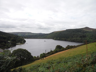
Evening View (with sheep) up Ladybower Reservoir, from Six-Way Junction
SWC Walk 348 - Ladybower Inn Circular (via Derwent Edges and Strines)
Sep-19 • thomasgrabow on Flickr
swcwalks swcwalk348 banner 48822564818

Views across Ladybower Reservoir from top of Whinstone Lee Tor over Crook Hill Twin Tops to Great Ridge and Edale
SWC Walk 348 - Ladybower Inn Circular (via Derwent Edges and Strines)
Sep-19 • thomasgrabow on Flickr
swcwalks swcwalk348 walkicon 48823098587
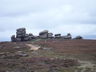
Wheel Stones, Derwent Edge
SWC Walk 348 - Ladybower Inn Circular (via Derwent Edges and Strines)
Sep-19 • thomasgrabow on Flickr
swcwalks swcwalk348 walkicon 48822578738
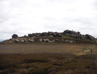
Back Tor, from Lost Lad
SWC Walk 348 - Ladybower Inn Circular (via Derwent Edges and Strines)
Sep-19 • thomasgrabow on Flickr
swcwalks swcwalk348 walkicon 48822572203

Boot's Folly, some sheep and Derwent Edge
SWC Walk 348 - Ladybower Inn Circular (via Derwent Edges and Strines)
Sep-19 • thomasgrabow on Flickr
swcwalks swcwalk348 walkicon 48822930866
View from Flank of Lead Hill across Ladybower Reservoir to its dam (Win Hill on right)
SWC Walk 348 - Ladybower Inn Circular (via Derwent Edges and Strines)
Sep-19 • thomasgrabow on Flickr
swcwalks swcwalk348 48822943226

Six-way Junction at Four-way Signpost
SWC Walk 348 - Ladybower Inn Circular (via Derwent Edges and Strines)
Sep-19 • thomasgrabow on Flickr
swcwalks swcwalk348 48823098932
| Length |
25.8 km (16.0 mi), with 850m ascent/descent. For a shorter walk see below Walk Options. |
|---|---|
| Toughness |
8 out of 10, with 6 ¾ hours walking time. For the whole outing, including trains, sights and meals, allow at least 13 hours. |
| Walk Notes |
A walk of contrasts on the Derbyshire/South Yorkshire boundary in the north east corner of the Dark Peak area of The Peak District. From the Ladybower Inn you rise in stages up to Derwent Edge, towering above the Upper Derwent Valley – with ever-improving views over the surrounding hills of the Central Dark Peak area and along Ladybower Reservoir. You then follow a clear and well-engineered path along the edge past some famous gritstone rock formations to the highest point of the walk at Back Tor and out to a magnificent viewpoint on Lost Lad hill. Derwent Head, Bleaklow and Kinder Scout dominate the views from here.
Options to shorten the route are described, as are Alternative Endings (or Starts) in High and Low Bradfield. |
| Walk Options |
You can cut the out-and-back to Back Tor and Lost Lad viewpoint (cuts 1.7 km/1.0 mi, but is certainly not recommended in good weather, however tired you are!).
|
| Maps |
OS Explorer: OL1 (The Peak District – Dark Peak Area)
|
| Travel |
Ashopton, Ladybower Inn Bus Stop, map reference SK 204 864, is 16 km west of Sheffield, 233 km north west of Charing Cross, 221m above sea level, and in Derbyshire. It is served by bus lines 257 and 273 from Sheffield Interchange to Castleton/Bakewell (journey time 25-29 mins from Sheffield (09/19: £3.50 one way, £5.50 return), and the SNAKE X57 from Sheffield to Manchester (30 mins). Sheffield is the terminus of the Midland Main Line from London St. Pancras, with up to two trains per hour (journey time from 118 mins Mon-Sat, longer on Sundays). Saturday Walkers’ Club: This walk can be done as a day walk from London, despite the infrequent bus service, but – on the current schedule – only Monday to Saturday. Take a train no later than 8.00 hours. |
| Lunch |
The Strines Inn Bradfield Dale, Mortimer Road, Sheffield, S6 6JE (01142 851 247). The Strines Inn is located 10.7 km/6.7 mi into the walk. It is a traditional pub in a 13th century farmhouse. |
| Tea |
The Ladybower Inn Bamford, Hope Valley, Derbyshire, S33 0AX(01433 651 241). The Ladybower Inn is a quaint stone pub with rooms (some offering views of the picturesque Ladybower Reservoir). Bradfield Endings:
The Plough Inn New Road, Low Bradfield, Bradfield Dale, Sheffield, S6 6HW(0114 285 1280). The Plough is located at the end of the Low Bradfield Ending from Dale Dike Reservoir.
|
| Profile | |
|---|---|
| Help Us! |
After the walk, please leave a comment, it really helps. Thanks! You can also upload photos to the SWC Group on Flickr (upload your photos) and videos to Youtube. This walk's tags are: |
| By Car |
Start A57, Hope Valley, S33 0AX Map Directions |
| Amazon | |
| Help |
National Rail: 03457 48 49 50 • Traveline (bus times): 0871 200 22 33 (12p/min) • TFL (London) : 0343 222 1234 |
| Version |
Apr-24 Thomas G |
| Copyright | © Saturday Walkers Club. All Rights Reserved. No commercial use. No copying. No derivatives. Free with attribution for one time non-commercial use only. www.walkingclub.org.uk/site/license.shtml |

Walk Directions
Full directions for this walk are in a PDF file (link above) which you can print, or download on to a Kindle, tablet, or smartphone.
This is just the introduction. This walk's detailed directions are in a PDF available from wwww.walkingclub.org.uk