Leigh to Sevenoaks walk
A gentle morning past fields and Oasthouses, then a steep climb to Knole Palace (NT) and its deer park
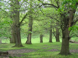
walk_21_BS_TREES_IN_KNOLE_PARK
May-05 • Bela Struzkova on Flickr
swcwalks book1 walk21 walkicon 36511605343

walk_21_BS_DEER_IN_KNOLE_PARK
May-05 • Bela Struzkova on Flickr
swcwalks book1 walk21 walkicon 36511593883
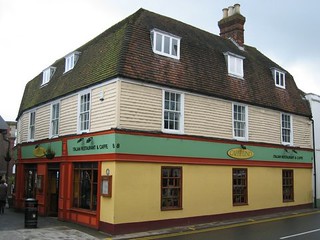

walk_21_BS_WHITE_HOUSE_IN_SEVENOAKS
May-05 • Bela Struzkova on Flickr
swcwalks book1 walk21 36927447790


Knole Park & Kent's 'rolling, tidal landscape'
| Length | 14.5km (9.0 miles), 4 hours 20 minutes. For the whole outing, including trains, Knole House and meals, allow 9 hours. |
|---|---|
| Toughness | 5 out of 10. |
| OS Maps | Explorer 147 or Landranger 188. Leigh, map reference TQ 546 462, is in Kent, 9km south of Sevenoaks. |
| Features |
The route of this lovely walk is through what Laurie Lee described as the 'rolling, tidal landscape' of Kent. The walk starts in the village of Leigh (pronounced 'Lie' from the Anglo-Saxon for 'forest clearing') with its many fine old buildings, goes through the churchyard and past the parkland of Hall Place, and carries on through fields and farms and past many an oasthouse (the conically roofed buildings used for drying hops) to the church and pub in Underriver, the suggested lunchtime stop. Mud warning During wet winters and after periods of prolonged, heavy rain many of the paths on this walk can be horribly muddy, so do wear appropriate footwear. After lunch at the pub in Underriver, it is sharply uphill (on an often very muddy path) to then follow the Greensand Way into magnificent Knole Park, passing the front entrance of Knole and leaving the park on a footpath to arrive in the centre of Sevenoaks. You need to start this walk in good time if eating at the pub in Underriver, as the bulk of the walk is before lunch. |
| Walk Options | There are rare buses (two a day Monday–Saturdays) from the lunchtime pub in Underriver to Tonbridge Station, or take a taxi. Directions to a permanently closed pub in Hildenborough have been left in as this alternative route reduces the amount of road walking mid-morning on the main route by more than half. |
| History |
Knole House, built in the fifteenth century (and so huge that it has a room for every day of the year), was visited by Elizabeth I in 1573, who granted it to Thomas Sackville. It remained in the Sackville family and was the childhood home of Vita Sackville-West, featuring in Virginia Woolf's Orlando. The house, with its tapestries, paintings and collection of seventeenth-century furniture, is open to visitors from mid-March to the end of October, Tuesday to Sunday (plus Bank Holiday Mondays and August Tuesdays) with last entry at 3.30 pm. Admission for NT members is free. Otherwise, charges (2024) are: Outdoors and Gatehouse Tower: £ 6.00. Family ticket and concessions available. House showrooms, outdoors and Tower: £ 16.00. The House stands in a park of 1,000 acres. There is no charge for walking in the park, nor accessing its Brewhouse Tearoom and in any case the route described in the walk directions follows public rights of way. |
| Travel |
Take the train nearest to 9.30am from London Bridge to Leigh Station, changing at Tonbridge (journey time 46 mins) or Redhill (journey time 1 hr 05 mins). On weekdays what used to be a direct service from Victoria to Leigh on the Tonbridge service is no more (since 2022). You can travel from Victoria on the Reigate service changing at Redhill. You could also travel from Charing Cross , changing at Tonbridge, time just over an hour. There are frequent trains back from Sevenoaks to Charing Cross, journey time 35 minutes, and occasional trains to Victoria changing at Petts Wood. Buy a day return to Leigh (Kent). Note As of 2024 you will need an Any Route Permitted version of your Leigh (Kent) day return ticket if you wish to have both Redhill and Tonbridge options for your outward journey. If driving, there are frequent trains from Sevenoaks to Tonbridge where you change for the one stop to Leigh. Sevenoaks Station is closer to London and the M25. It has several large car parks (Mon-Fri: £6, Sat: £2, Sun: £1), but you can park near Leigh Station for free. |
| Lunch |
The White Rock pub (tel 01732 833 112), Underriver, some 8.7 km into the walk, serves lunch (as of 2024) on Monday from 12 noon until 3 pm. Tuesday pub CLOSED, Wednesday to Friday from 12 noon until 3.30 pm, on Saturday from 12 noon until 4 pm and on Sunday from 12 noon until 4.30 pm. The pub has a Lite menu on weekdays, plus a full menu on all days, with a Sunday menu offering traditional roasts plus many other dishes. On Sundays walkers and walk posters should plan ahead and book at least two weeks in advance to reserve a table, although a few of you can usually squeeze in for service at the bar. Groups of walkers should always 'phone ahead. This pub used to be one of the most unfriendly establishments on our SWC walks, but currently (2024) the staff and management are walker friendly and hospitable - and the quality of the food and choice of draught beer is very good. What was a good alternative pub, coming earlier during the morning leg of the walk, following an alternative route, the Cock Horse pub, Hildenborough, sadly closed permanently in November 2019 after some 500 years as a pub. |
| Tea |
The refurbished Brewhouse Tearoom (tel 01732 450 608) has an entrance in the north wall of Knole House, without the need to pay an entrance fee. During British Summer Time this pleasant tearoom is open unto 5 pm with last orders 4.30 pm and serves cream teas. In winter the tearoom closes earlier: suggest you 'phone ahead to check. There are various options in the centre of Sevenoaks including Caffè Nero at 112 High Street (tel 01732 779 050) and Costa Coffee at 2 Blighs Rd (01732 462 159). The branch of the popular Bills seems to have closed (summer 2024). Other cafes frequented and liked by SWC walkers include: Malabar Coffee House (tel 01723 743 055) at 81 High Street, open until 5 pm: Basil Wholefoods (tel 01723 496 430 ) at 3-5 Bank Street, good for healthy food and vegetarian and vegan options. For stronger refreshments in the town centrte, there are several pubs and popular with SWC walkers is the former coaching inn on the High Street, the Chequers Inn (tel 01732 450 144) which serves food from 5 pm on weekdays and all day at weekends. Close to Sevenoaks Station is another possibility, the Swiss Alpinia Patisserie at 1 Tubs Hill Parade (tel 01732 454 669) open till 6 pm Monday to Saturday. Within the main foyer of Sevenoaks Station are two coffee / tea franchises, handy for a takeaway drink on your journey home. |
| Updates |
Several changes to the Books directions so use the online version. [Pre 2011 editions] Use the online edition - it avoids busy road crossings. Latest minor updates following a book check and walk uodate - April 2023. Tea and admissions update October 2024. |
| Book |
This walk was originally published in Time Out Country Walks near London volume 1. We now recommend using this online version as the book is dated. The book contained 53 walks, 1 for every week of the year and 1 to spare. Here is our suggested schedule |
|---|---|
| Profile | |
| Help Us! |
After the walk, please leave a comment, it really helps. Thanks! You can also upload photos to the SWC Group on Flickr (upload your photos) and videos to Youtube. This walk's tags are: |
| By Train |
Out (not a train station) Back (not a train station) |
| By Car |
Start TN11 8RU Map Directions Return to the start: Finish TN13 1DP Map Directions Travel to the start: |
| Amazon | |
| Help |
National Rail: 03457 48 49 50 • Traveline (bus times): 0871 200 22 33 (12p/min) • TFL (London) : 0343 222 1234 |
| Version |
Oct-24 Marcus |
| Copyright | © Saturday Walkers Club. All Rights Reserved. No commercial use. No copying. No derivatives. Free with attribution for one time non-commercial use only. www.walkingclub.org.uk/site/license.shtml |


Walk Directions

- [1] From Leigh Railway Station platform 2, exit down the tarmac path, your direction 285°, to the road and turn right (If you have come via Tonbridge you will arrive on platform 1; go down its tarmac path to the road where you turn right and go under the railway bridge.)
- Continue on the road past what used to be a garage and car showroom (in the To Book Directions) and is now a new housing development, and then the Fleur-de-Lis pub to the main road, B2027.
- Turn right and continue for 300 metres. Just before a brick bus shelter on your left and with a school on your right, cross the road to turn left northwards, uphill on a tarmac lane to St Mary's Church (worth a look inside).
- Go up four steps and pass through a metal swing gate into the churchyard. Follow the path to the right of the church and exit through the lych-gate.
- In 10 metres turn left, taking the footpath, initially along a car drive, your direction 345°, past the impressive gatehouse leading to Hall Place on your left and through a wooden fieldgate marked Porcupine House.
- In 80 metres go through a metal kissing gate and keep straight on with the field fence and ancient trees and parkland of Hall Place to your left, and an open field to your right. In 230 metres go though another metal kissing gate and keep straight on through a potentially muddy area, still following the fenceline on your left-hand side.
- In 170 metres ignore the next metal kissing gate at the end of the field and fork right to go through a metal squeeze stile then over a concrete bridge and stream, to keep ahead on a path with light woodland to your left. After 100 metres continue on the path on the left-hand side of a large grassy field, gently uphill, your direction 15°.
- In 150 metres the path levels out and you keep ahead. In a further 110 metres go past a redundant stile to pass through a band of trees and in 40 metres pass through a gap next to a collapsed stile and turn left onto an earth lane, your direction 305°.
- [2] In 150 metres, and 10 metres before the end of this lane, just before a cottage on your left, follow the low footpath sign to go half right northwards, with a field fence on your right.
- In 30 metres this path enters a wood on a wide earth track. 10 metres into the wood, at a path junction, turn half-right, following a footpath sign, up a wide path, your direction 345°. In 120 metres bend right with the path, your direction initially 35°, along a bridleway, soon gently downhill. In season you are now surrounded by carpets of bluebells.
- In 200 metres exit the wood through a metal squeeze stile (a potentially muddy area) and go straight on, with the field edge, fence and ditch on your left.
- In 100 metres cross a stream over a concrete slab bridge and go through a metal squeeze stile to the left of a fieldgate (another possibly muddy area). Carry straight on, slightly left, your direction 20°, with a stream tributary on your left (dried up in summer) and an oasthouse (marked as Lower Street Farm on the OS map) further off to your left.
- In 150 metres go through a metal fieldgate and continue up the earth track. In 55 metres you come up towards a car road and pass through a rusty metal kissing gate to the left of a pair of fieldgates. Go straight across the minor road and continue by a public footpath sign over a two plank bridge over a ditch, then over a stile, and continue straight ahead, with a field boundary on your right, between large fields, your direction north.
- In 475 metres at the end of this field go over a stile (or through the usually open fieldgate to its left), another potentially muddy spot, and continue on with the hedge now on your left, your direction 345°.
- In 105 metres go over another stile to the right of a rusty, metal fieldgate and then [!] go half right to cross the field diagonally, your direction 35°, towards a stile in its far right-hand corner. In 200 metres, and 10 metres beyond a pond on your right, cross the stile to come out onto a road.
- [3]. The main route has you turning right here but if you wish to divert to Hildenborough on a route which involves less road walking, turn left and follow the directions at the end of the main walk directions. [Jan-24] The Hildenborough option is blocked by a closed railway crossing, and the pub on this route is no more.
- Main directions : having turned right once over the stile, continue along the road (Philpots Lane) and in 70 metres you go over a brick walled bridge over the railway. In a further 430 metres you come to the road bridge over the A21 and cross it. Carry on for 90 metres and you come to a road T-junction, where you cross the road and turn left. Continue ahead along the pavement of Watts Cross Road for 500 metres to reach the B245. [!] But NOTE: if you wish you can cut the corner some 175 metres before you reach this B road by taking the footpath to your left, to follow a path diagonally right across a field to then turn right up a grassy bank to the road.
- The original rote continues: turn left at the road junction and in 70 metres go past Mill Garage then turn right on to Mill Lane.
- [4] In 165 metres when the road bends to the left and opposite Meadow House, take the signposted footpath to your right and pass through a metal swing gate, cross a small paddock and in 20 metres go over a stile. Keep ahead over the open field, aiming for the wooden footbridge visible in the distance. In 250 metres go over the narrow wooden footbridge with wooden handrails over a stream.
- Continue ahead, over a grassy field, your direction 70°, and in 50 metres you have a bluebell coppice on your left-hand side. Keep ahead, gently uphill and at the end of the coppice keep ahead across a field. In 100 metres go through an open metal fieldgate (or if closed, go through the metal kissing gate to its right).
- Now bear two thirds left on a bearing of 20° and in 140 metres, at the corner of the field, follow the direction of a yellow arrow turning to your right , with two ponds on your left (the first is part hidden).
- In 8 metres cross a stile and turn left into an open field, keeping close to its left-hand edge, your direction 70° (you may have to walk around a mound of earth and agricultural waste). Horses usually occupy this field. In 160 metres leave the field through the metal kissing gate some 35 metres to the right of the field entrance.
- In 5 metres go over a three plank wooden bridge and through a metal kissing gate to revert to your previous direction, 70°, now going down the centre of a small, grassy field with a manege horse training area on your left. In 85 metres go through a metal kissing gate and turn left onto a farm track.
- After 8 metres turn right towards a stile marked by a yellow arrow. Cross the stile and continue on the path with a horse training ground on your left and stables ahead. In 15 metres at the end of the path turn sharp right to go through a wooden swing gate and turn left over grass, keeping the breeze-block wall on your left, your direction 50°. After 20 metres go through a wooden fieldgate (usually propped open) and head out along the gravel driveway of Brambles House, and in 70 metres you come out onto the road.
- Turn left on the road, northwards, passing Hadlow College Princess Christian's Farm with farm shop on your right. In 120 metres you come to Vines Lane on your left. The diversion from the Hildenborough route rejoins the main route here .
- [5] Ignore Vines Lane and keep along the road for a further 150 metres, where you turn left at a public footpath sign and a sign saying Woodside, your direction 325°. Continue along the wide path with fences on both sides.
- After 200 metres, when the wide path ends, go over a stile and cross a large, open field, down its middle, your direction 330°.
- In 275 metres, you have the start of a back garden fence on your left-hand side, and then a fir hedge. In 130 metres bear right to cross over a farm track and keep ahead over another field, your direction now 345°. In 150 metres enter a strip of woodland and in 15 metres cross a stile, and turn half left into a field, your direction 270°.
- Follow the direction of the mini-pylons westwards, to the edge of the back garden of a house. Here turn right , your direction 320°, keeping the edge of the gardens to your left. In 115 metres, exit the field by a stile on the left, 15 metres before the field corner, with a footpath sign 5 metres ahead of the stile at the edge of a car road.
- Turn right on the car road and in 20 metres at a three-way road junction take the car road to the right , gently uphill (the signpost to Shipbourne is missing since May 2021). In 220 metres, near the brow of the hill, ignore a footpath and stile to your right. In a further 375 metres along the road, as it starts to descend, where a road goes off to the right (again signposted to Shipbourne) you go left over a stile, due west, on a signposted public footpath with a field fence and what previously was a tennis court on your right - and is now a manege.
- Go straight on along the right-hand edge of a field and in 350 metres go over a stile with a metal fieldgate to its left. Cross a grassy farm access and in 10 metres go through a wooden swing gate, and keep ahead up an avenue of trees, with a fenceline to your right, your direction 290°. In 160 metres go over a stile with a rusty metal fieldgate 5 metres to its left and keep ahead (slightly left) on the path, now gently downhill. In 125 metres go over a wooden footbridge with wooden handrails over a stream (culverted to your right) and keep ahead. In 45 metres go through a metal kissing gate on to an earth car lane, with Green Lane Cottage Farm on your right, and keep ahead, gently uphill.
- [6] In 275 metres at a T-junction with a tarmac road, turn right due north, downhill, in 65 metres passing St Margarets Church Underriver. In a further 75 metres you come to the White Rock pub, the suggested lunchtime stop.
- Coming out of the pub after lunch, turn right on the road and in 130 metres ignore the footpath on the right to continue gently uphill. In a further 100 metres, opposite a road to the right signposted Shipbourne, take the wide lane signposted public bridleway to your left, your direction 305°.
- In 100 metres you pass Black Charles House on your right to continue steadily uphill on a track which soon narrows to a path in a cutting. In 320 metres turn right up a restricted byway with an oasthouse barn visible ahead to your left, your direction 345°. Continue now steeply uphill in a cutting on a potentially very muddy path overarched with trees, in a woodland strip.
- In 150 metres take the path to your left, following purple discs, which runs parallel to the muddier path to your right. In 200 metres the paths converge, and you keep ahead, still steeply uphill, now in a deeper cutting. In a further 180 metres, near the top of the hill, you pass a path on the right marked Greensand Way. 20 metres after this, fork upwards to the left. In 10 metres cross a stile marked Greensand Way to the right of a metal gate.
- In essence you now just follow the Greensand Way until you come to a car road, but in more detail: Continue on a grassy way, initially due west, with the field edge on your left, along the way of a horse eventing area ahead and to your right (Redlands Field). In 130 metres bear right at the corner of the field, your direction now 340°. 100 metres on from this bend turn left across a stile, your direction 290°, into a wood. The path winds gently downhill through the wood and after 200 metres you exit the wood at a car road.
- [7] Cross the road to enter Knole Park through a deer protection gate.
- Continue straight ahead, slightly downhill, in your previous direction. In 100 metres you come to a junction of tarmac roads and take the one straight ahead, your direction 325°. In 750 metres, at the top of a rise, at a tarmac path T-junction, continue ahead through an opening, now on an earth path, your direction 315°. Keep ahead towards a corner in the walled garden of Knole House, soon visible ahead.
- About 100 metres before you reach the wall, fork left onto a wide grassy path that runs parallel to the wall, gently downhill, your direction 305°. You can get a good view of the side of Knole House through the second set of metal railings along the wall. At the end of the wall, turn right to reach the main entrance of Knole House.
- If you want tea now, go past the main entrance and keep ahead to the end of the wall, where you turn right to head down the road and at the bottom of a dip, turn right to enter the newly refurbished Brewhouse Tearoom with the Conservation Studios and WCs to its right.
- Otherwise continue ahead (or turn right on leaving the house if you have visited it) on the curved driveway, due north. In 85 metres from the entrance cross another road and immediately turn half-left on the grass with no clear path uphill, heading for a clump of trees at the top of the rise, your direction 315° (on a line that is a continuation of the line of the side wall of Knole House behind you). You may need to weave your way round parked cars.
- Once there, following a footpath sign to the right, go downwards over grass, your direction 305°. In 150 metres keep a crater depression on your right. You are now on a clear path marked by a footpath sign that leads to a tarmac drive. Cross it to carry straight on, along a clear path, downhill, your direction 300°.
- You head down into a dip - a grassy valley bottom - then start to head uphill. After 200 metres you leave Knole Park by a deer protection gate to go steeply uphill, your direction 265°.
- In 200 metres keep to the tarmac path as you pass the Sevenoaks Leisure Centre car park on your right. Continue past the end of the car park with a wall on your right and railings on your left, coming out opposite Waitrose. [8] Cross the road and continue to the right of the public toilets (Akehurst Lane) your direction 255°. This leads out to Sevenoaks High Street.
- Alternatively cross the Sevenoaks Leisure Centre car park diagonally to the opposite corner where you turn left, following the sign for the Tourist Information Office. After 50 metres you come to a road; cross it and carry on straight ahead past the bus stops to arrive at Sevenoaks High Street.
- There are various possibilities for tea in Sevenoaks. For Malabar Coffee House and Caffè Nero turn right down the High Street. For Costa Coffee, cross the High Street, turn right and continue to Blighs Road.
- After tea you will need to get to London Road which runs west of the High Street for the station. From Costa Coffee cross the car park to the far side where steps lead down to London Road; then turn right downhill. From Caffè Nero carry on along the High Street to the traffic light junction where you turn left along Pembroke Road; when you reach London Road, turn right.
- Continue for about 1km down London Road to reach Sevenoaks Railway Station on the left for frequent trains to London.
Detour to Hildenborough, to reduce the amount of road walking
[Jan-24] Route blocked by a closed railway crossing
- Having crossed the stile at point[3], turn left on Philpots Lane, soon heading gently downhill. In 240 metres [!] , just before a property on your right called Old Barn Oak, turn right to cross a stile in a hedge, by a low concrete footpath marker, with an electricty pole on your right. Keep ahead on a grassy way with a mesh garden fence to your left and a hedge to your right, your direction 340°.
- In 100 metres you pass a pond on your left and in a further 40 metres cross a stile to the right of a metal fieldgate and turn half-right over a grassy field, your direction due north.
- In 200 metres cross a stile and go over the railway, crossing another stile on its far side. Now head down through a woodland strip to go over a ditch on a wood plank and up past a redundant gate and over a stile to head half-right over an open, grassy field, your direction due north.
- In 250 metres you pass to the immediate right of a coppice and you bear left with the coppice to your left. In 100 metres, in the far left-hand corner of the field, you cross a stile and in 8 metres cross a road at a bend and take the footpath ahead, through a woodland strip. In 10 metres cross another stile, with a pond over to your left, to come out into a large, open field. Turn left along the field edge, your direction 45° with a tree line to your left.
- In 220 metres, in the far left-hand corner of the field, go over a stile with a rickety metal fieldgate to its right, and a small pond over to your left, and keep ahead along the left-hand edge of the next, large open field. In 300 metres, in the field's top left-hand corner, bear left to cross a stile and in 10 metres go through a wooden kissing gate and head up to cross over a footbridge over the A21 road.
- On the far side of the footbridge follow the path as it swings left in a full circle, downwards. At the bottom go over a stile and keep ahead through light woodland. Cross a pair of stiles, 10 metres apart, to come out into a field. Follow its left-hand edge in a southerly direction and in 40 metres you pass a brick shed on your left.
- Here turn left and in 10 metres cross a stile to the right of a metal fieldgate. Now cross a bridge over a stream and head up a drive, your direction 45°. In 60 metres you come to the closed Cock Horse pub on your left-hand side at the junction with the B245 road. Demolition of the building is imminent (June 2021).
- Cross over the road and take the signed footpath directly ahead, going up steps to cross over a stile into a field. Keep ahead down its left-hand edge (a field boundary) with tree line to your left, your direction 70°. In 100 metres your way starts to go downhill. You pass a pond and a wooden shed on your left and just before the field corner swing left then turn right into the adjacent field, to continue in the same direction as before.
- You head down into a dip, cross a ditch and then head up, in 120 metres passing a bluebell coppice on your left-hand side. Keep ahead, gently uphill, and 70 metres beyond the end of the coppice, you enter a woodland strip. In 80 metres exit the woodland and keep ahead (a quarter right) over the next field, aiming for a solitary tree 100 metres away. Pass this tree on your left and keep ahead over the field.
- In 130 metres you pass a clump of trees surrounding a pond to your right and you keep ahead, now down the left-hand side of the field. In 100 metres go over a stile in the left-hand corner of the field, to come out at a triangular road junction, with Vines Lane directly opposite.
- Walk down the length of Vines Lane, and in 550 metres you come to a T-junction with the road, 150 metres before point [5] in the main walk directions. Turn left to rejoin the main walk directions.