Macclesfield Circular via Teggs Nose and Kerridge Hill Walk
Tegg’s Nose Country Park, Macclesfield Forest, the Dean Valley, Lamaload Reservoir, Kerridge Ridge with its picturesque folly, the White Nancy
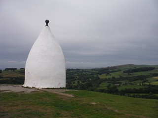
White Nancy
SWC Walk 382 - Macclesfield Circular (via Tegg's Nose and Kerridge Hill)
Jun-21 • thomasgrabow on Flickr
swcwalks swcwalk382 banner 51330684115

Bottom and Teggsnose Reservoirs and Croker Hill, from Tegg's Nose
SWC Walk 382 - Macclesfield Circular (via Tegg's Nose and Kerridge Hill)
Jun-21 • thomasgrabow on Flickr
swcwalks swcwalk382 walkicon 51329898268
Saddler’s Way Concessionary Bridleway descending into Walker Barn Stream valley; Shutlingsloe in distance
SWC Walk 382 - Macclesfield Circular (via Tegg's Nose and Kerridge Hill)
Jun-21 • thomasgrabow on Flickr
swcwalks swcwalk382 walkicon 51329689366

Tegg's Nose, from Hacked Way Lane
SWC Walk 382 - Macclesfield Circular (via Tegg's Nose and Kerridge Hill)
Jun-21 • thomasgrabow on Flickr
swcwalks swcwalk382 walkicon 51329689451

Ankers Knowl Farm and Lamaload Reservoir
SWC Walk 382 - Macclesfield Circular (via Tegg's Nose and Kerridge Hill)
Jun-21 • thomasgrabow on Flickr
swcwalks swcwalk382 walkicon 51330683535
| Length |
24.7 km (15.4 mi), with 866m ascent/descent. For a shorter or longer walk see below Walk Options. |
|---|---|
| Toughness |
8 out of 10, with 6 ¾ hours walking time. |
| Walk Notes |
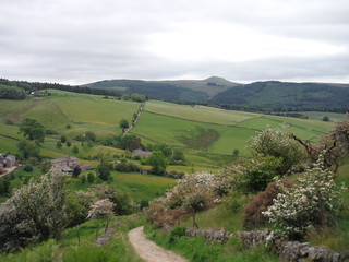
This is a varied route out of the historic Silk Town of Macclesfield through the Tegg’s Nose Country Park and the Macclesfield Forest, across lonely pastures with views into the Dean Valley and past the Lamaload Reservoir then back along the 2 km long Kerridge Ridge with its picturesque folly, the White Nancy. You climb steeply out of town along residential roads to quickly emerge amongst pastures and rolling hills and ascend further to Tegg’s Nose, a formerly quarried hill, with its handful of fine viewpoints into the surrounding valleys, from where you descend through the valley of the Walker Barn stream and rise again through Macclesfield Forest to the isolated Forest Chapel. From there, cross undulating pastures with views to the stark high moors separating Dark Peak and White Peak and to Cheshire’s highest tops, Shutlingsloe and Shining Tor, eventually descending towards the remote Lamaload Reservoir in the Dean Valley.
The first 9.2 km of the walk to Forest Chapel (and a full 15.4 km – all the way to Shining Tor – on the Long Walk) are identical with the sister walk Macclesfield to Buxton. |
| Walk Options |
Bus Line 58 (Macclesfield – Buxton via Cat & Fiddle), with an hourly service Monday-Saturday and five buses on Sundays and Bank Holidays, offers various stops close to the route toeither shorten the walk by cutting out a stretch at the start or for starting or finishing the Long Walk by The Cat & Fiddle pub/distillery (about half-way). See the route map for the location of the stops.
Bus Line 60 (Hayfield – Macclesfield) enables an earlier finish from Rainow, Robin Hood PH (15.8 km) or Kerridge-end (Bus Stop Rainow/Calrofold Lane, 20.6 km). As of 07/2021, the bus runs hourly in the afternoon Mon-Sat, with the last one at 18.32 Mon-Fri and 17.35 Sat at Robin Hood PH and 2 mins later at Calrofold Lane.
|
| Maps |
OS Explorer: 268 (Wilmslow, Macclesfield & Congleton) – just for the urban start – andOL24 (The Peak District – White Peak Area)
|
| Travel |
Macclesfield Station, map reference SJ 919 736, is 237 km northwest of Charing Cross, 133m above sea level and in Cheshire East. It is on the Stafford to Manchester branch line off the West Coast Main Line from London Euston (hourly service). Travel time from London is from 101 minutes Mon-Sat (but 2 ¼ hours on Sun). Saturday Walkers’ Club: The walk is doable as a daywalk from London with a train no later than 09.20 hours. |
| Elevenses |
Tegg’s Nose Tea Room Tegg’s Nose Country Park, Buxton Old Road, Macclesfield, Cheshire, SK11 0AP (07955 532 703). The Tea Room is located 5.8 km (3.6 mi) into the walk. |
| Lunch |
The Forest Distillery Chambers Farm, Bottom-of-the-Oven, Macclesfield Forest, near Wildboarclough, Macclesfield, Cheshire SK1 0AR (01260 253 245). The distillery is located 530m off route, 9.8 km (6.1 mi) into the main walk and 11.3 km (7.0 mi) into the Long Walk.
|
| Lunch or Tea Long Walk |
The Cat & Fiddle Buxton New Road, Macclesfield, Cheshire, SK11 0AR (01298 73711). The Cat & Fiddle is located 150m off route, 14.2 km (8.8 mi) into the walk. Built in 1813, and long England’s second highest pub, it closed in December 2015 with an uncertain future. Robinson’s Brewery have recently sold it to the Forest Distillery though, who intend to open it as Britain’s highest altitude distillery, with a pub attached.
|
| Tea |
The Robin Hood Details as above. The Robin Hood is located 100m off route, 9.1 km (5.7 mi) from the end of main and long walk options.
|
| Profile | |
|---|---|
| Help Us! |
After the walk, please leave a comment, it really helps. Thanks! You can also upload photos to the SWC Group on Flickr (upload your photos) and videos to Youtube. This walk's tags are: |
| By Train |
Out (not a train station) Back (not a train station) |
| By Car |
Start Map Directions |
| Amazon | |
| Help |
National Rail: 03457 48 49 50 • Traveline (bus times): 0871 200 22 33 (12p/min) • TFL (London) : 0343 222 1234 |
| Version |
Oct-21 Thomas G |
| Copyright | © Saturday Walkers Club. All Rights Reserved. No commercial use. No copying. No derivatives. Free with attribution for one time non-commercial use only. www.walkingclub.org.uk/site/license.shtml |


Walk Directions
Full directions for this walk are in a PDF file (link above) which you can print, or download on to a Kindle, tablet, or smartphone.
This is just the introduction. This walk's detailed directions are in a PDF available from wwww.walkingclub.org.uk