Mam Tor to Kinder Low walk
Peak District out-and-back ridge walk around Edale from a car park at 420m to Mam Tor, Lords Seat, Brown Knoll, Swines Back and Kinder Low (633m)
| Length | Up to 10.1 miles (16.3 km) with 1,550 feet (475 m) of elevation. |
|---|---|
| Toughness | 3 / 10 |
| Walk Notes |
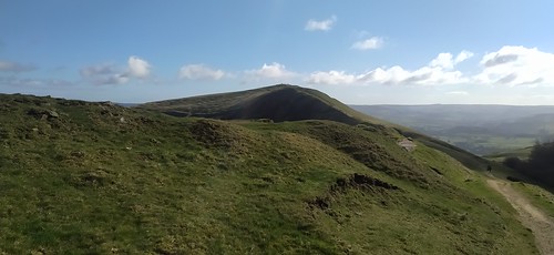
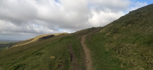
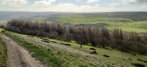
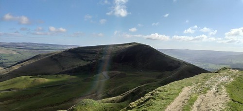
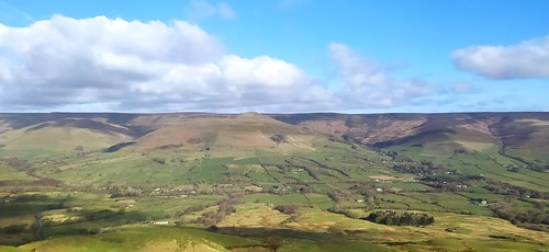
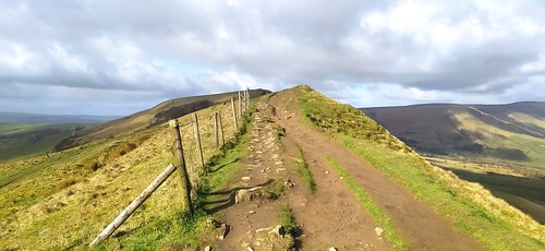
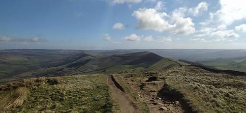
This is a mostly gentle ridge (apart from an optional steep climb at the start) above Edale from Mam Tor car park (420m; 1,410 feet) to Mam Tor (524m), Lord's Seat (550m), Brown Knoll (569m), and Swines Back (569m) to Kinder Low (633m), just shy 3m of the summit of Kinder Scout The walk starts from an NT car park with an optional short but steep (62m) out-and-back climb to Mam Tor (trig point) along a stepped path. The remainder of the walk is gently ascending a long ridge to Kinder Low around the Edale valley. The first part, follows a wide grassy ridge parallel to the valley passing Lord's Seat. The ground is earth rather than bog, so its is muddy-in-winter / firm ground in summer. The path is easy to see, and follows a dry stone wall much of the way. Then next part, around the head of the valley, and along the Pennine Spine to Brown Knoll (trig point), is along a stone slab path a boggy flat plateau that gently slopes away to either side. Due to the stone slab path, the route is obvious (except under deep snow). Just before the short climb to Swine's Back you're joined by the Pennine Way. Then its another gentle ascent to Kinder Low (trig point) Here, you're just 3m shy of the summit of Kinder Scout. It's 500m off in the featureless bog to your right. You'd need a GPS to find it! Best time to look for it is at the end of a dry summer (September), or in the winter when the ground is frozen, but as its in the middle of a flat plateau, you're not doing it for the view. This is a very popular walk, as the parking at 1,410 feet gives easy access to an easy ridge walk along the tops. Get there early or midweek, especially in summer or good weather. Mam Tor especially, being next to the car parking, has a queue by midway on sunny weekends. |
| Options |
|
| Safety |
|
| Travel |
Mam Nick NT car park, S33 8WA (Nearest postcode). NT: free, otherwise £4.50 (4 hours) or £6 (all day). There is some marked roadside parking nearby (see map). Access: Winnats Pass is very steep, and can occasionally be closed in winter. The route from Edale is less steep, and from Chapel-en-le-Frith isn't steep at all. Being one of the highest roads in the Peak District, with easy access to the tops, the parking fills up very early at weekends and in summer. Get there before 8am if possible, or much later in high summer when people are leaving. There is some free road side parking. Stick to marked spaces. You can get a ticket if there are yellow lines even if you are totally off the road. They do ticket/tow if you block the road. Due to chaos over Easter '24 these are likely to be more strictly enforced. There is also a little roadside parking along Rushup Edge to the west of Lord's Seat by the Rushop Hall turnoff. The last resort is Old Mam Tor road which starts at the bottom of Winnats Pass. Its closed half way along. You might park as high as 270m, depending on how early you get there, and how close to the end you park. At least its a lovely walk (180m ascent) to the start of the ridge along the closed road. |
| Profile | |
|---|---|
| Help Us! |
After the walk, please leave a comment, it really helps. Thanks! You can also upload photos to the SWC Group on Flickr (upload your photos) and videos to Youtube. This walk's tags are: |
| By Car |
Start NT Car Park Map Directions |
| Amazon | |
| Help |
National Rail: 03457 48 49 50 • Traveline (bus times): 0871 200 22 33 (12p/min) • TFL (London) : 0343 222 1234 |
| Version |
Apr-24 Andrew |
| Copyright | © Saturday Walkers Club. All Rights Reserved. No commercial use. No copying. No derivatives. Free with attribution for one time non-commercial use only. www.walkingclub.org.uk/site/license.shtml |
