Mitcham Junction to Colliers Wood walk
Nature Reserves and the Wandle Trail through south London.
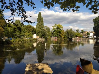
View from the cafe overlooking Carshalton Ponds
Sep-20 • Andrew Murphy on Flickr
swcwalks swcwalk273 50297534797
| Length |
Main Walk: 15½ km† (9.6 miles). Three hours 15 minutes walking time. For the whole excursion including trains, sights and meals, allow at least 6½ hours. Alternative Walk, from Waddon: 14½ km† (9.0 miles). Three hours walking time. † Subtract 2¼ km (1.4 miles; 30 minutes) if finishing at Morden. See Walk Options below. |
|---|---|
| OS Map |
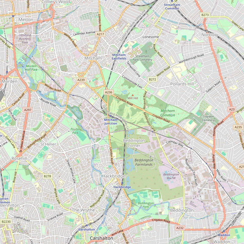
Explorer 161. Mitcham Junction, map reference TQ282676, is in south London, 4 km SE of Wimbledon. Colliers Wood is 2 km E of Wimbledon. |
| Toughness |
1 out of 10. |
| Features |
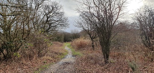
This south London walk is in the proposed Wandle Valley Regional Park, a newly-designated area along the course of this tributary of the Thames. Described as ‘London's hardest-working river’, the fast-flowing chalk stream once supported nearly 100 watermills along its short length. There are many traces of the river's industrial past and one surviving watermill which is still in working order can be seen near the end of the walk, at Merton Abbey Mills. Much of the walk follows the waymarked Wandle Trail, a 22 km walking and cycling route from Croydon to Wandsworth. However, the preferred starting point for this walk is from the station on Mitcham Common, near the centre of the new Regional Park. A short stretch across the common leads to a permissive footpath along the western boundary of Beddington Farmlands, the site of a controversial new “Energy Recovery Facility”. As part of the planning conditions Viridor were obliged to transform much of this old landfill site into an urban nature reserve by 2023, restoring its status as an important birdwatching location. However, Viridor sold off the site in March 2022 and the new owner seems equally unwilling to meet the conditions (and Sutton Council seems just as unwilling to enforce them). Hopes that there might eventually be an interesting alternative route from Mitcham Common to Beddington Park are fading. The walk continues through Beddington Park and Grove Park to the Wandle's other source in the picturesque setting of Carshalton Ponds, a conservation area surrounded by several interesting buildings. As well as stopping for lunch you could explore the grounds of the Sutton Ecology Centre (open daily; free entry) and perhaps visit the Honeywood Museum of local history (open Thu–Sat to 5pm; free admission) or the Water Tower (open summer Sundays 2.30–5pm; admission £2). After Carshalton the walk turns round to head north as it follows the course of the river towards the Thames. Although never far from residential streets and business parks, much of the Wandle Trail is through riverside parks and local nature reserves, including Watermeads. The largest open space is Morden Hall Park, 125 acres of parkland owned by the National Trust and the suggested place for a tea stop. In the final section the riverside path passes Deen City Farm (open Tue–Sat to 4.30pm; suggested £2 donation for admission). You could explore the craft shops and eateries at Merton Abbey Mills before heading to Colliers Wood underground station. |
| Walk Options |
An Alternative Walk incorporating the first part of the Wandle Trail was provided when the permissive path alongside Beddington Farmlands was closed for a lengthy period in 2018. As there are no appealing routes from central Croydon the alternative directions are from Waddon station to Beddington Park; you have to start by crossing the traffic-choked A23 (Purley Way) but the route does go through an attractive small park, Waddon Ponds. You could also start this option from the Wandle Park Tramlink stop. If you want to extend the walk past Colliers Wood you could continue along the Wandle Trail to Earlsfield (an extra 3 km) or Wandsworth Town (6 km). Directions for this extension can be found on the Colliers Wood to Putney Bridge walk page. A new riverside section has been opened at Earlsfield, part of some ongoing improvement works on this rather urban stretch of the trail. Conversely, there are many places where you could cut the walk short. The simplest option is to finish at Morden Hall Park by heading to Morden underground station or a nearby Tramlink stop. You could also use the station at Carshalton to split it into two short walks. Link routes to these and other nearby stations and tram stops are briefly described. There are also many bus routes in the area. |
| Transport |
Mitcham Junction (in TfL Zone 4) is served by Southern trains from Victoria taking 22 minutes, plus Thameslink trains through central London taking slightly longer; the off-peak service is half-hourly on both routes. The next two stations (Hackbridge and Carshalton) are close to the walk route and have the same service. Waddon (Zone 5) is served by Southern trains from Victoria taking around 37 minutes, plus faster ones from London Bridge (Mon–Sat) taking 22 minutes (both half-hourly). At the end of the walk the most convenient transport option is the Northern line, with underground stations at Morden (Zone 4) and Colliers Wood (Zone 3). From the Croydon or Wimbledon areas you could access this walk via Tramlink. There are stops at Mitcham Junction and Wandle Park, and near the end of the walk the Phipps Bridge and Morden Road stops are just outside Morden Hall Park. |
| Suggested Train |
Take a train or tram which would let you to start the Main Walk at around 11am, or the Alternative Walk at 11:15am. |
| Train Times |
|
| Timetables |
|
| River Levels |
|
| Lunch |
There are several refreshment places on and around the walk route, but the most convenient place to stop for lunch is in Carshalton (6¼ km from Mitcham Junction, 5¼ km from Waddon). Three quite different pubs which are worth considering are the large Greyhound Hotel at 2 High Street (020-8647 1511), which describes itself as “a traditional pub with a stylish twist” in a fine location overlooking the ponds; The Hope at 48 West Street (020-8240 1255), a community pub with an old-fashioned feel as you go in but a modern conservatory at the back, serving simple ‘pot meals’ with an extensive choice of real ales and ciders; and The Sun at 4 North Street (020-8773 4549; closed Mon), an attractive pub with a walled garden and more elaborate food offerings. |
| Tea |
There are several places where you could break for refreshment towards the end of the walk. At the National Trust's Morden Hall Park (020-8545 6850) there is the Potting Shed Café serving hot food and the Stableyard Café for cakes and other light snacks. A little further on there is a café at Deen City Farm. Stronger fare is available ten minutes before the end of the walk at Merton Abbey Mills. Alongside the river the William Morris (020-8540 3254) pub has reopened after being closed for several years; the small Merton Apprentice serves craft beers and ciders. If you want some final refreshment before catching the tube the Charles Holden (020-8540 1918) pub opposite Colliers Wood station has a large beer garden backing on to Wandle Park. |
| Profile | |
|---|---|
| Help Us! |
After the walk, please leave a comment, it really helps. Thanks! You can also upload photos to the SWC Group on Flickr (upload your photos) and videos to Youtube. This walk's tags are: |
| By Train |
Out (not a train station) |
| By Car |
Start CR4 4HN Map Directions Finish SW19 2HR Map Directions |
| Amazon | |
| Help |
National Rail: 03457 48 49 50 • Traveline (bus times): 0871 200 22 33 (12p/min) • TFL (London) : 0343 222 1234 |
| Version |
Apr-24 Sean |
| Copyright | © Saturday Walkers Club. All Rights Reserved. No commercial use. No copying. No derivatives. Free with attribution for one time non-commercial use only. www.walkingclub.org.uk/site/license.shtml |

Walk Directions
Click the heading below to show/hide the walk route for the selected option(s).

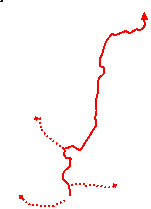


 Walk Map
©
Walk Options
Click on any option to show only the sections making up that route, or the heading above to show all sections.
- Main Walk (15½ km)
Walk Directions
If you are doing the Alternative Walk (from Waddon), start at §B.
-
Mitcham Junction Station to Carew Manor (3½ km)
-
The shortest way to start the walk is to go up the tarmac ramp from the Wimbledon-bound Tramlink platform and turn left onto the main road at the top.
- If arriving by train from London you could also leave via the ramp on that side of the station, turn left onto the main road and cross over the railway bridge.
-
50m beyond the Tramlink exit veer left past a barrier onto Mitcham Common. Follow the main path for 500m, gradually curving to the right; at first the tramway is on your left, later the railway in a cutting.
This part of Mitcham Common is known as the Gunsite because anti-aircraft batteries were sited here during the Second World War.
-
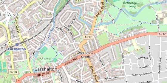
At the end of the path cross over the railway on a substantial footbridge. On the far side do not take the obvious tree-lined path heading E but turn right past metal barriers onto a long permissive path on the western boundary of Beddington Farmlands, parallel to the railway.
Behind the embankment on the left are some flooded gravel pits, part of the new urban nature reserve. Along the way there are a few short gravel paths leading to rudimentary bird hides with good views over these lakes.
-
In 600m the path veers left and right where there used to be a footbridge over the railway. In a further 400m it does the same by a bridge over the railway at Hackbridge.
- If starting from Hackbridge station turn right onto the A237, go up to a mini-roundabout and turn right into Furlong Close. Where this private road bends left, keep ahead on a path going up a slope and over the railway. At the bottom of the slope turn right onto the boundary path to join the walk.
-
On the final 500m of this permissive path there are good views of the Southern Lake, with Hackbridge station off to the right. Go out past metal barriers into a belt of trees on the boundary of Beddington Park.
This open space was once part of the deer park attached to Carew Manor. Its large estate originally extended as far north as Mitcham Common but was gradually sold off as the family's fortunes declined.
- Turn left along the edge of the park, either on the tarmac path or a woodland path through the belt of trees. If you take the latter you will need to join the tarmac path where it swings right after 250m.
-
Follow the tarmac path past the park's Pavilion Café (a possible early refreshment stop), coming to a low Terracotta Bridge over the River Wandle.
In 1859 the Carew estate (though not the manor house) was bought by a wealthy clergyman, Canon Bridges. He made many improvements and additions to the grounds, including this ornamental bridge.
- Instead of joining the Wandle Trail here, cross the bridge and continue along the driveway. At East Lodge (where the Alternative Walk route joins from the left) keep ahead into Church Lane.
-
Waddon Station to Carew Manor (2½ km)
- Outside the station turn right onto Epsom Road and go up to its junction with the A23 (Purley Way).
- Turn right at the traffic lights and go over the railway to another set of lights at the junction with the A232. You need to get onto the residential street (Waddon Court Road) diagonally opposite this busy junction, so go straight across the minor road ahead and then cross the A23 at the lights on the far side.
-
Go down Waddon Court Road for 75m. Shortly after passing Court Drive turn left into a small park, Waddon Ponds.
These ponds were once thought to be one of the sources of the River Wandle, but there is in fact an underground stream from Wandle Park.
-
Take either of the two paths off to the right around a small pond (they rejoin on the far side) and continue along the right-hand side of the park, now with a larger pond on your left. At the far end leave the park and turn left onto Mill Lane, joining the waymarked Wandle Trail.
- If starting from the Wandle Park Tramlink stop head south on Vicarage Road and turn right into Waddon Road. Go straight across the A23 at the traffic lights to continue along Mill Lane, in 150m passing the gate where the route from the station leaves Waddon Ponds.
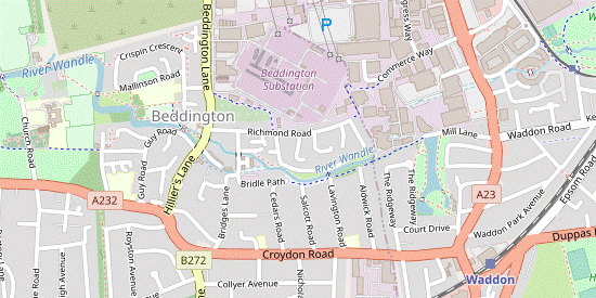
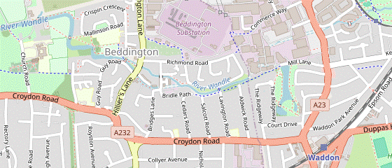
- Where the lane enters a trading estate continue on the tarmac path to its left, a public bridleway. In 250m the tree-lined path passes a cul-de-sac on the left (Aldwick Road). In a further 100m, opposite Lavington Road, turn right onto a footbridge across the River Wandle.
-
Turn left onto a street between the Richmond Green housing development and a patch of wet grassland containing a small balancing pond.
The pond collects rainwater runoff from the development and is part of some new flood prevention measures on the River Wandle.
- Where the street swings right keep ahead near the river on a tarmac footpath, which leads into Kingston Gardens. At the end of this short street turn left into Wandle Road, crossing back over the river.
-
In 75m turn right briefly into Bridges Lane, passing the attractive Mount Pleasant cottages on the other side of a branch of the river and with the converted Beddington Mill behind you.
This was one of many mills on the river. The brick building was built in the 1890s as a flour mill; an earlier mill here was used for grinding tobacco into snuff.
-
Where the street turns left keep ahead on the riverside footpath. At the far end use the pedestrian crossing to get across Hilliers Lane and turn right. After crossing the river turn left through either of two entrances into Beddington Park.
Inside the second entrance there is an information panel about Beddington and its dominant landowner, the Carew family.
- Go through the small strip of parkland, then cross the bridge on the right into an open area. Keep left to stay on the path parallel to the river, later passing some newly-planted fruit trees. In the corner the path swings round to the right, passes a small cascade and turns left into another open area.
-
Take the left fork to go diagonally across this rough grassland, then back across the river. Continue along a newly-planted avenue of ornamental cherry trees towards a small car park and the buildings of Carew Manor.
The Carew estate originally extended as far north as Mitcham Common but was gradually sold off as the family's fortunes declined. …
-
Go through the car park and out along its access road. At the end of a row of cottages fork left away from the river (temporarily leaving the Wandle Trail). Follow the driveway round a gentle curve to the right, passing a large octagonal brick building on the left, the Dovecote.
This supplied eggs and meat to the Carew estate; it is an early 18thC replacement for an older building.
- At East Lodge (where the Main Walk route joins from the right) turn left into Church Road.
-
Carew Manor to Carshalton (2¾ km)
-
Head south along Church Road, passing Carew Manor on the left.
Carew Manor was originally a medieval moated house and a fine hammerbeam roof in its great hall survives from that period. After the Carew family sold the house it was converted into an orphanage and is now a school.
-
On the left you pass St Mary's church (which has a coffee shop, open on some weekdays). At the end of its churchyard turn right onto a tarmac path, signposted as a combined pedestrian / cycleway.
The medieval St Mary's church was completed in the late 14thC. Canon Bridges funded a major refurbishment in Arts and Crafts style in the late 19thC.
- In 200m keep ahead past barriers where the cycleway swings off to the left. In a further 60m turn left at the next path junction, onto a tree-lined avenue.
-
At the end of the avenue the path curves right and comes to a long footbridge over the centre of a boating lake (originally a millpond). You could turn left as indicated by a Wandle Trail signpost, but the suggested route is to cross the bridge and turn left onto the lakeside path, passing a small ornamental garden.
The Grange was acquired by the borough in 1935 and its garden is now part of the public park; the building is an up-market restaurant and wedding venue.
- Follow the path around the far end of the lake, crossing two outflows. Go straight across a car park onto a paved path through a small garden area, (re)joining the Wandle Trail.
- After skirting around a pond keep left and follow the path out to a road. Cross over and keep ahead along a short residential street (Lakeside), parallel to the A237 on the right. At the end bear right, cross the A237 at the traffic island and go around either side of a semi-circular pond towards the Rose & Crown.
- Do not follow the signposted Wandle Trail Short Cut along Butter Hill to the right; instead veer left past the front of the pub and a convenience store, then turn right into Westcroft Road.
-
At the end of this cul-de-sac turn right towards Westcroft Leisure Centre. In front of the building turn left across a wooden footbridge into Grove Park.
The Grove and its ornamental garden were acquired by the local council in 1924 and the park opened to the public a few years later.
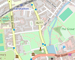
- Keep ahead along a tarmac path, aiming for the far left-hand corner of the park. In this corner pass to the left of a children's playground and follow a short driveway between houses down to Carshalton Ponds, with the imposing All Saints church on the A232 (Carshalton High Street) off to the left.
-
Go along the right-hand side of the Lower Pond. Unless you want to take a short cut, continue across the stone Leoni Bridge.
The Venetian architect Giacomo Leoni had been commissioned to design a mansion (which was never constructed) and it is a conjecture that he designed this bridge of white Portland stone. The outflow from the Lower Pond is the start of this branch of the River Wandle.
- If you do not want to stop at any of Carshalton's refreshment places you can turn right onto the path in front of the bridge, alongside the outflow from the Lower Pond. The main route rejoins from a footbridge on the left immediately after this path passes the Cascade. If you take this short cut, resume the directions at [?] in §D.
-
For the full walk follow the path out through a gap in the high brick wall to the B277 (North Street). Cross the road and continue on Honeywood Walk alongside the Upper Pond, passing between Carshalton War Memorial and a Garden of Remembrance.
The War Memorial was erected in 1921. The original metal panels containing the names of the soldiers were stolen in 2011, but a local scrap metal dealer funded replacement stone plaques. The Garden of Remembrance was laid out after WW Ⅱ.
-
At the end of the pond the Honeywood Museum is on your left.
The museum is in a 17thC house, restored to show living conditions in Victorian and Edwardian times. It has exhibitions about local history, a shop and a small tearoom.
-
Unless you want to visit the Greyhound Hotel (the first of the possible lunch pubs, off to the left across the High Street) keep ahead on Festival Walk. At the start of this footpath the entrance to the Sutton Ecology Centre is on the right.
This is a small Local Nature Reserve divided into various habitats: woodland, meadows, demonstration gardens and a large pond.
- For a short detour you could follow a nature trail through this reserve. There is no other exit so you would need to return to this point.
-
Festival Walk runs alongside a dried-up river bed and passes an enormous London Plane tree.
A plaque records that this is the largest known plane tree in Britain, 123 feet tall with a girth of more than 20 feet.
-
The footpath comes out onto the B278 (West Street) in front of Carshalton Water Tower.
As well as supplying piped water to Carshalton House and its grounds this 18thC building contained an orangery, a saloon for entertaining guests and a sunken bath lined with blue and white Delft tiles.
-
Turn right onto West Street, in 150m passing The Racehorse pub on your left. Unless you want to visit The Hope (another possible lunch pub a little further ahead on West Street) turn right into West Street Lane.
- To end the walk at Carshalton station continue along West Street past The Hope and turn right into Station Approach, just before the railway bridge.
-
Carshalton to Middleton Road (3 km)
-
Go all the way along West Street Lane. At the far end of this narrow street the last of the possible lunch pubs is across North Street on the left, The Sun.
- If starting the walk from Carshalton station, turn left down Station Approach and turn right onto the B277 (North Street) to reach the crossroads by The Sun.
-
At the crossroads go through a wide entrance in the high brick wall to re-enter Grove Park.
- If this vehicle entrance is locked there is a pedestrian entrance a little further down North Street.
-
Bear left through a parking area and follow the path round to the right past Grove Mill's old waterwheel. After crossing a water channel with the Cascade on your right, turn left at a path junction.
This ornamental feature was originally designed to create a head of water for the mill.
- Keep left at path junctions to stay close to the water channel. Follow the path out of the park and immediately turn right onto a path between the backs of houses and the river, parallel to Mill Lane off to your left.
-
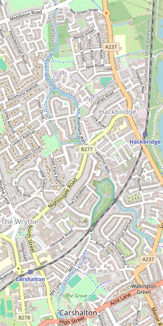
Keep ahead across Papermill Close. At the end of the riverside path bear left across a patch of grass to continue along Mill Lane. Shortly after passing under the railway bridge there is an entrance on the right to Wilderness Island.
This is a Local Nature Reserve managed by the London Wildlife Trust. There is an information panel describing its varied habitats and a map showing a figure-of-eight nature trail.
- For a short (5-10 minute) detour you could follow the trail through the woodland and wetlands on this small island, situated between the two branches of the river which merge at its northern end. There is no other way off the island but you can do either a full or half circuit before returning to this point.
- To continue the walk, keep ahead into a residential street (River Gardens), with the island on your right. Shortly after this street turns left turn right onto a signposted footpath to stay alongside the river.
-
The riverside path eventually goes through an attractive Community Garden and comes to the B277 (Nightingale Road) at Hack Bridge.
This enterprising garden was created by a local Brazilian artist and sculptor, Claudio Funari (1948-2022), with flower beds and sculptures created from scrap metal salvaged from the river.
-
Ignore a footpath on the other side of the road and turn right to cross over the river. Unless you want to finish the walk here turn left onto the riverside path.
- To finish the walk at Hackbridge station (600m away) continue along the B277 (now Hackbridge Road) and turn right at the mini-roundabout where it meets the A237; the station is ahead on the left.
-
The river soon splits into two branches. Ignore a footbridge and continue alongside the river, with a new housing development on your right.
This is part of a major regeneration project for the Hackbridge area.
- Go straight across Culvers Avenue to continue with the river on your left. Later the tarmac path emerges onto a patch of grassland between the river and Watercress Park. Fork left at a couple of path junctions to go back across the river on a footbridge.
-
Bear right onto a tarmac path running alongside a metal fence, with Wandle Valley Wetland behind it.
This small Local Nature Reserve is managed by a local conservation group. It is not usually open to the public.
-
The path comes out onto a side road. Bear right and go up to the main road (Middleton Road).
- To finish the walk at Mitcham Junction station (900m away) turn right and go all the way along the main road (which becomes Goat Road) to its junction with the A237. Cross this busy main road with great care onto Mitcham Common. Turn left onto any path staying close to the main road, eventually bearing left onto a broad path (the outward route) to return to the A237. Go up the main road for 50m and turn right onto a tarmac path sloping down to the Tramlink platforms; you can cross the tracks to reach the platform for trains to London.
-
Middleton Road to Morden Hall Park • Stations (3½ • 4 km)
- Cross over Middleton Road and continue alongside the river on Watermeads Lane, just off to the right. This cul-de-sac leads into a new surfaced riverside path, with the extensive playing fields of Poulter Park up the bank on your left.
-
Ignore paths off to the left to stay alongside the river. In 600m keep right where the cycle route veers up to the left. After passing a sports pitch on the left you come to the entrance to Watermeads Nature Reserve.
- If the gate is locked take the public footpath on the left past the sports ground to the A217 and resume the directions at [?].
-
For the main route go into this Local Nature Reserve, turn right and simply follow the main path as it makes its way around the perimeter, keeping the river on your right. After passing a large sluice gate the path drops down and crosses a couple of small footbridges.
Off to the left of the second bridge is a sandstone bench dedicated to Miranda Hill, who with her sister Octavia (a founder member of the National Trust) started the appeal to save Watermeads. It was acquired by the NT in 1913 but only opened to the public in 2015.
-
The path comes out onto the A217 (Bishopsford Road) next to the public footpath. Unless you want to finish the walk here, cross the road and turn right onto the footway across the river.
- To finish the walk at Mitcham Tramlink stop (400m away) turn right onto the A217. At the junction with the A239 turn right down Tramway Path for the stop.
- After crossing the river veer left into Ravensbury Park. The riverside path goes past some houses and crosses a couple of water channels, the second on a large metal footbridge with a square centre. Unless you want to make a longer loop through the park, turn left to stay alongside the river.
-
Go all the way along the riverside path, passing some fine ornamental trees (including two Ginkgo biloba near a footbridge across the river). At the end the path goes over another large metal footbridge (with a circular hole in the middle) and comes out onto the A239 (Morden Road).
At this end of the park some machinery and millstones on the left are a reminder of the river's industrial past.
-
Turn right and go along the main road for 150m, crossing over at the pedestrian lights halfway along. Just before the Surrey Arms turn left into Morden Hall Park.
The estate was owned by Westminster Abbey until the Dissolution of the Monasteries, then for three centuries by the Garth family as Lords of the Manor. In 1872 it was sold to the Hatfeild family who laid out the park in its present form. The house and estate were left to the National Trust when its last private owner died in 1941.
-
An information panel at a three-way path junction shows that you could keep ahead on the main tree-lined avenue, but for the suggested route fork left. The path curves round to the right, soon with a branch of the river close by on your left. In 250m go through a metal gate into the Rose Garden.
- If you are doing this walk late in the day you will have to skirt around the garden as the gate is locked at 6pm (5pm in winter). On the far side turn left onto a path leading to the White Bridge and cross the water channel there; to continue to Colliers Wood turn right and resume the directions at [?] in §F.
- For the main route follow the path along the right-hand side of the garden. Unless you want to attempt a crossing of the stream flowing through the middle, follow the path out of the garden, turn left to cross the stream on a low bridge and immediately turn left again.
-
Go back through the other side of the Rose Garden towards a cluster of buildings. After passing a small school you cross a branch of the river with a conserved waterwheel on the left, followed by the Snuff Mill.
This used to contain a small exhibition about the history of snuff-taking but is now a “Children and young people hub”.
- The Stableyard Café is through an opening on the right. For more substantial fare continue on the driveway alongside the mill-stream and go through an archway in the cottages on your left; the Potting Shed Café is on the right, opposite the Garden Centre.
-
Finishing at Morden (+½ km)
- For Morden underground station leave the park via a pedestrian exit at the end of the driveway. Cross the A297 (Morden Hall Road) at the traffic lights to your right and continue along Aberconway Road opposite. The station is at the end of this road, on the other side of the A24.
- For Phipps Bridge Tramlink stop retrace your steps through the first part of the Rose Garden. After turning right to cross the stream follow the path straight ahead, then fork left at a junction to come to the tram stop just outside the park.
-
Morden Hall Park to Colliers Wood Station (2¾ km)
- From the Garden Centre area retrace your steps past the cottages to the cluster of buildings around the Snuff Mill.
-
Fork left in front of the footbridge leading to the Rose Garden. Go alongside a water channel towards the White Bridge and bear left at a junction of paths there, with Morden Hall off to the left.
The manor house dates from the 1770s. The National Trust have leased it to Whitbread plc but the building is currently unused.
- After crossing more water channels you come to another path junction. Turn right (briefly leaving the Wandle Trail) onto the path signposted to the Wetland Boardwalk, passing an information panel about this new area.
-
The path initially goes alongside a water channel and then curves round to the left on a long boardwalk through the reed-filled wetlands, with some viewing points along the way. On the far side you come to a path T-junction.
- To finish the walk at Morden Road Tramlink stop (400m away) keep ahead on a grassy path alongside the tree boundary on your right. In the far corner of the park go out onto the A24, cross this busy main road carefully and turn right. On the bridge over the tram tracks turn left down a flight of steps for the stop.
- At the T-junction turn right to rejoin the Wandle Trail. Cross the tram tracks in a series of zig-zags and fork right onto a wide surfaced path. This soon turns left to continue between the river and Deen City Farm, which you can glimpse through the trees on your left.
- The path comes out onto a driveway, with the entrance to the farm behind you. Ignore the bridge over the river and keep ahead (slightly to the left) past the farm's overflow parking area, still with the river on your right.
-
Go straight across Windsor Avenue to continue alongside the river for a further 175m, then turn right to cross it on a footbridge into Merton Abbey Mills, where there are several information panels about the area's history.
This was once the site of a large medieval monastery, Merton Priory. After the Dissolution it became an important area for textile works, with the river providing both clean water and power. In 1881 the workshops were acquired by the designer William Morris, a leading exponent of the Arts and Crafts movement. Textile production was continued by Liberty's and other manufacturers until 1982.
-
The William Morris pub is by the river; if you explore this small site you will find several eateries. On the far side the Merton Apprentice pub is next to the small Colour House Theatre.
This children's theatre is in the oldest building on the site, originally used for dyeing fabrics.
-
To complete the walk go back across the river on another footbridge a bit further along, where looking back you can see a conserved waterwheel attached to the Wheelhouse.
This is the only watermill on the Wandle still in working order. It is now a pottery workshop and gallery, and on summer weekends you might see the water power turning a potter's wheel.
-
Turn right to rejoin the main riverside path, passing a small Memorial Garden on the right.
This garden is dedicated to Paul Bowness, Chairman of the Wandle Heritage Trust, who died in 1998.
-
Follow the path out onto the A24 (Merantun Way). Cross this busy main road at the pedestrian lights and go through an archway opposite, on the site of the entrance to Merton Priory.
A plaque records that this archway was built in 1988 when a Norman arch was demolished during the construction of Merantun Way. Sections of the medieval precinct walls remain on either side.
- Turn right and then veer left to continue on the riverside path. In 300m the path comes out onto the A238 (Merton High Street). Colliers Wood station is 350m away and is signposted along the main road to the right, but for a little relief from the traffic turn right to go back across the river.
- Turn left in front of Sainsbury's onto the continuation of the riverside path, which bends away from the river and comes to a retail park. Veer left through its car park and make your way between Burger King and Currys to the A24.
- Cross this road at the traffic lights off to the right and turn left into a side street (Christchurch Road). The underground station is at the end of this short street. If you want some refreshment, the Charles Holden pub is on the other side of the A24.
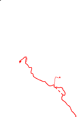
⬅ North (map rotated 90°)
Continue the directions at §C.
⬅ North (map rotated 90°)
If you are not continuing to Colliers Wood, complete the walk with one of the two sets of directions below.
⬅ North (map rotated 90°)
» Last updated: March 3, 2024
Return to Top | Walk Map | Walk Options | Walk Directions.