Netley to Botley walk
The Solent Way and the River Swanick with sea views, marinas and mudflats

Hamble marshes
Botley to Netley walk
Sep-16 • Saturdaywalker on Flickr
swcwalks book1 walk3 walkicon 29605373592

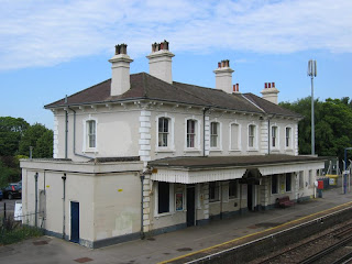
Hamble ferry
Botley to Netley walk
Sep-16 • Saturdaywalker on Flickr
swcwalks book1 walk3 walkicon 29090004614
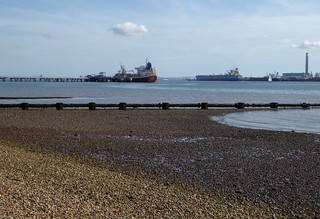
Ships at low tide, Southampton Water
Botley to Netley walk
Sep-16 • Saturdaywalker on Flickr
swcwalks book1 walk3 walkicon 29090068484

Royal Victoria Park, Netley
Botley to Netley walk
Sep-16 • Saturdaywalker on Flickr
swcwalks book1 walk3 walkicon 29605372772

Southampton Water and the River Hamble
| Length | 15.18km (9.43 miles), 4 hours 15 minutes. For the whole outing, including trains, ferry, sights and meals, allow 9 hours 45 minutes. Allow an extra 30 minutes in summer if visiting the Netley Chapel centre and the Manor Park farm. |
|---|---|
| OS Maps |
Explorer OL 22 & OL3 (was 119) or Landranger 196. Netley, map reference SU 464 086, is in Hampshire, 5km south-east of Southampton. |
| Toughness | 2 out of 10 |
| Features |
The walk goes down through the Royal Victoria Country Park, past the Netley Chapel, down to the shore at Southampton Water, with a dramatic view of the vast Fawley oil refineries opposite. Then the way is along the stony beach for a couple of kilometres, followed by an inland path through the woods and Hamble Common to the ferry in the delightful village of Hamble. The Warsash Ferry (Enquiries tel 02380 454512: Duty Boatman tel 07827 157154) returns to Hamble every ten minutes or so: in summer from 9 am to 6 pm Saturday and Sundays and 9 am to 4 pm Monday to Friday, and in Spring (commencing March ) from 10 am to 4 pm Saturday and Sunday and 10 am to 3 pm Monday to Friday. In January and February there is a weekend service only, but if you call the Duty Boatman he will turn out for you.(closed Christmas week). The fare is (2024) £2.50 per adult for a single crossing, with room for up to 12 people. Bring cash for your fare. On the other side of the river, the walk continues up alongside the River Hamble, with its marinas for yachtsmen and mudflats for birds – every variety from Grey Herons and Kingfishers to Redshank and Lapwing (binoculars are worth bringing). Lunch is in Lower Swanwick. Then it is up the other side of the river on a choice of routes to Manor Farm and Country Park, an open farm run for visitors by Hampshire Council, with a tea-room open 7 days in summer until 31 October (last orders 4.45 pm). The route ends in a pleasant footpath called Lovers Lane, over a stream and up into Botley, where there are three pubs and one tea shop. It is then a not-very-pleasant 820 metre walk along the main road to the station, with a good pub (across a very busy road) opposite that serves food all afternoon. |
| Tide Times |
Near the start of the walk, and when the tide is in, you have to walk along the top of the stony beach to Southampton Water (unless you nip in and out of the woodland on your left). Walking along the beach for a distance of two kilometres can be hard work. At low tide, however, your way is along a lower, sandier part of the beach which is much easier. Try to arrange the walk with a low tide an hour or so after the start. See: Tide times - Warsash (near Hamble) If doing the walk in reverse, aim for low tide near the end of the walk Note that the Solent has unusual tides (4 per day!) and that tide times are always in GMT, add 1 hour in the summer for BST. |
| Historical Notes |
This walk replaced the original Walk 3 in the Country Walks Book at its second edition, due to problems with the lunch place. That original walk, Dunbrige to Romsey, has since been re-written. This walks position in the Book's rota - Walk 3 on Week 3 - meant a January outing for a coastal walk, which could be "envigourating" and nippy in deep winter. In the last edition of the Book, the walk's position in the rota was moved to mid-summer, a more suitable time of year to enjoy this lovely walk along the coast. This walk works just as well when done in "reverse" - Botley to Netley, and the reverse directions follow at the end of the main directions, together with an optional extension to Sholing. |
| Walk Options |
To shorten the walk, take one of the hourly trains (seven days a week, summer and winter) from Bursledon after lunch, either via Southampton or Fareham. Or much earlier in the walk, you could get one of the regular buses from Hamble (Nos. 16 or 16a) to Netley station or to Southampton town centre. After lunch you have a choice of routes up to Manor Farm and Country Park. The Book's original route is a direct route, which heads due north, and is easy to follow, but its final leg is along an uninteresting track for 1 kilometre. The alternative, slightly longer route follows the "Strawberry Trail" above the river, dropping down to several attractive coves - but you need to follow the directions carefully to avoid becoming lost in deep woodland. Botley to Netley As mentioned earlier, this walk works just as well when done in reverse (Botley to Netley). This way round, you follow the the river Hamble to the sea, then finish by walking along the shoreline of the Solent. Another advantage of this is the outward journey to Botley is direct and takes ninety minutes (versus over two hours to Netley), allowing a later start of 10 am. Full directions of the "backwards walk" follow after the main directions. |
| History |
Netley Chapel in the Royal Victoria Country Park was at the centre of the Royal Victoria military hospital that opened in 1863 and was demolished in 1966. Now the Heritage Visitor Centre, it houses an exhibition and a shop and allows visits to the top of the tower. But it is only open from about April to October. Phone 023 8045 5157 for details. The hospital pier was begun in 1865 and was 190 yards long. Now, only the pier head remains. Inscribed on the spit slate to the right of the pier is a poem by Frank Thompson:’Write on the stones no words of sadness, only the gladness due that we who ask the most of living, know how to give it too. Manor Farm and Country Park (tel 01489 787055) with its farm, wheelwright and blacksmith’s forge and tea-room, is open Monday to Sunday from Easter to Oct 31st (till 5 pm); from November 1st to Easter (and during February half term) on Thursday to Sunday to 4 pm. Entrance fee to the Farm for 2024 is £ 10 for adults, with concessions for children under 16 and senior citizens, and under 3 year olds free of charge. There is no charge for access to the tea-room. The building of the parish church next to the farm started in 1282. The church was damaged by a tree that fell in the 1700s. |
| Travel |
Take the train nearest to 9 am from Waterloo Station to Netley, changing at Southampton Central (allow at least 5 minutes to change trains). Journey time about 2 hours, depending on the connection. There are hourly direct trains back from Botley to Waterloo. Journey time about 1 hour 35 minutes. You can also return in the other direction, changing at Fareham, but this takes over 2 hours. Buy a day return to Netley, which in practice is accepted for the return journey. |
| Lunch |
Harper's Steakhouse (The Navigator) formerly the Navigator pub and before that the Spinnaker (tel 01489 572123) in Lower Swanwick, some 8.5 km into the walk (or 6.7 km when doing the walk "backwards")serves food (full menu) from 12 noon to 2-30 pm, and ligher meals, hot and cold from 2-30 pm to 6 pm, Monday to Saturday, and roasts on Sundays between 12 noon and 3 pm, with lighter meals from 3 pm to 6 pm. The pub tends to be crowded on Sundays so book in advance, and on other days if you are a group of 10 or more. Almost opposite Harper's and within Premier Swanwick Marina is the popular Boat House Cafe (tel 01489 885745) with a good, varied menu and open all day for food from 9 am, with a full bar. Earlier in the walk, towards the end of the long section on the causeway beside the River Hamble, your earlier lunch option within the Universal Marina - formerly Bistro 8 Bar & Restaurant - is now Banana Wharf (tel 01489 250073) open Monday to Wednesday from 10 am to 3 pm, Thursday and Friday from 10 am to 9 pm, Saturday from 9 am to 9 pm, and on Sunday 9 am to 6 pm. Still within the Universal Marina is Mermaids at Universal (tel 01489 287350) a new cafe with very comfortable seating areas, serving lighter fare, open from 9 am until 4-30 pm. |
| Tea |
An early tea can be had at Manor Farm and Country Park in season, but otherwise there are three pubs in the pleasant village of Botley and a tea shop. The pubs are the Brewery Bar on Winchester Street, the Bugle Inn on the High Street and opposite it, The Dolphin. The tea shop is Elsie's Traditional Tea Room (tel 01489 781950) at 27 High Street, which is open until 4 pm Monday to Friday, 5 pm on Saturday, but 3 pm on Sunday (making it a non-starter for Sunday walkers). Opposite Botley railway station is the more-than-adequate Railway Inn (tel 01489 799746), open until late daily, and serving food all day at weekends. If not stopping at Manor Farm or if you are too late for Elsie's, this is probably the best bet for your tea stop. Just before Botley railway station you have a Londis Convenience Store within the BP petrol station, where you can buy machine tea and coffee, snacks and cold drinks. |
| Updates |
No major changes. 2024 prices added February 2024. Last Book check and walk update July 2021. |
| Tides |
27-Jul :
high: 04:07
high: 06:06
low: 09:37
high: 16:59
high: 18:29
low: 22:05
28-Jul :
high: 04:36
high: 07:20
low: 10:29
high: 17:14
high: 19:41
low: 23:04
29-Jul :
high: 05:33
high: 08:09
low: 11:32
high: 18:12
high: 20:34
30-Jul :
low: 00:16
high: 06:40
high: 09:11
low: 12:47
high: 19:19
high: 21:45
31-Jul :
low: 01:38
high: 07:51
high: 10:56
low: 14:06
high: 20:24
high: 23:25
01-Aug :
low: 02:51
high: 08:59
high: 12:10
low: 15:14
high: 21:26
02-Aug :
high: 00:28
low: 03:47
high: 11:03
high: 11:53
low: 16:08
high: 22:22
Times for . Corrected for BST if appropriate. Contains ADMIRALTY® tidal data: © Crown Copyright and database right.
|
|---|---|
| Book |
This walk was originally published in Time Out Country Walks near London volume 1. We now recommend using this online version as the book is dated. The book contained 53 walks, 1 for every week of the year and 1 to spare. Here is our suggested schedule |
| Profile | |
| Help Us! |
After the walk, please leave a comment, it really helps. Thanks! You can also upload photos to the SWC Group on Flickr (upload your photos) and videos to Youtube. This walk's tags are: |
| By Train |
Out (not a train station) Back (not a train station) |
| By Car |
It is not easy to return to the start by train, as the stations are on different rail lines. Start SO31 5AN Map Directions Return to the start: Finish SO30 2DY Map Directions Travel to the start: |
| Amazon | |
| Help |
National Rail: 03457 48 49 50 • Traveline (bus times): 0871 200 22 33 (12p/min) • TFL (London) : 0343 222 1234 |
| Version |
Apr-24 Marcus |
| Copyright | © Saturday Walkers Club. All Rights Reserved. No commercial use. No copying. No derivatives. Free with attribution for one time non-commercial use only. www.walkingclub.org.uk/site/license.shtml |


Walk Directions
Netley to Botley (the main walk)
- [1] Coming off platform 2 at Netley Railway Station cross over the footbridge, go out of the station the other side for 20 metres through the car park, then turn left on the road, signposted Royal Victoria Country Park, your direction 145°. In 120 metres the road ends at a cul de sac and you keep ahead, to the left-hand side of house number 30, past a ‘No Cycling’ sign, now on a surfaced path, soon with a steep wooded valley below to your right-hand side and light industrial units on the other side of a mesh fence to your left.
- 200 metres down this path, turn right on a tarmac road, your direction 235°, past No. 4 Taylor Cottage on your left-hand side. In 90 metres you come to a road junction, with a notice board with a map of the Royal Victoria Park 10 metres ahead of you, slightly right. Here, turn left for 15 metres then turn right on a surfaced road, by a "Police and Residents Only" sign, your direction 165°. In 120 metres, where the road swings to the right, keep ahead passing between two wooden posts on to a surfaced path, your direction 205°, with the tower of Netley Chapel visible ahead to the south. In 70 metres, go through a wooden barrier and turn left on a tarmac road, your direction 145°. The road swings to the right and in 60 metres, take a right fork on to another road.
- In 80 metres, enter the park proper, with the Cedar Tea Room (open May to October 9.30 to 5, November to April 9.30 to 4 ) a YMCA (which opened in 1940) and toilets on your right-hand side. Head for the chapel, due south, on a surfaced path with a miniature railway track running parallel to your path on your left. In 100 metres cross a road and keep ahead, now over grass, and in 200 metres you come to the Netley Chapel, now The Heritage Visitor Centre.
- From the front of the chapel, head straight on down a surfaced path between lamp-posts for 140 metres to Southampton Water , your direction 235°.
- At the pier head,[2], turn left along the shore, and in 90 metres, by the entrance to Netley Sailing Club , continue along the beach for the next two kilometres to the pier, its pipes and crane visible in the distance.
- On the way, you will in due course see ways up into the trees that border the shore, and you can follow paths there (including ‘Hamble Valley’ and ‘Strawberry Trail’) which run parallel to and above the beach, if you so prefer.
- On reaching the oil terminal security fencing you will need to leave the beach up stone steps to follow the concrete path next to the fence, still along the shoreline.
- In 320 metres go down steps and so under the pier (with its oil pipelines) to continue straight on until you reach the end of the fence in 200 metres. Here you go down concrete steps to continue along the shore but [!] in 5 metres turn left through a gap on to a path through light woodland, your direction 50°. In 40 metres at a T-junction and with a footpath post on your left, turn left on to a gravel path which soon swings to the right to pass a footpath post marked "Hamble Common Circular Trail".
- You come out into a grassy glade which you cross and in 60 metres you re-enter the light woodland on a wide path which swings to the left.
- In 90 metres, cross over a four-plank footbridge and keep ahead, slightly left. In 60 metres, fork left at a path junction, to follow the direction of another Hamble Common trail sign. In a further 80 metres by a footpath-signed post and a rustic wooden bench, [!] turn right (where to continue would lead you in 20 metres to a rustic totem pole!), your bearing 140° Do not be tempted by the wider path, turning back on yourself on a bearing of 175°.
- Stay with this twisty trail through woodland (houses visible to your left), and in 180 metres exit the wood by going over wooden boards (by water) on to a tarmac road. Here turn left on this road, your direction 30°. In 40 metres, and some 8 metres before you reach a Hamble Common road sign on your right, turn right into a car park, your direction 120°, to go past a barrier to follow a path into the wood.
- In 90 metres, ignore a ‘Hamble Common’ sign to the left (pointing to the path to your right) and instead keep ahead, now on the Strawberry Trail. In a further 90 metres, keep half-left with the main path and in 25 metres go over wooden slats, to bear left, now beside the River Hamble on your right. In 100 metres, the path swings left, then right. Ignore a kissing gate to your left-hand side; keep going through the copse on a winding path.
- In 100 metres you pass a Hamble Common sign on your right, to keep ahead. In a further 160 metres, you exit the wood by going over boards, passing a noticeboard and another Hamble Common sign on your right, keeping ahead for 30 metres where you join a gravel access road. Turn left and in another 50 metres, by a ‘No Entry’ signs for cars, turn right downhill on the road passing Oyster Cottage on your right and other Hamble Village houses, your direction 75°.
- By the water’s edge, go left towards the white metal pier, at the end of which you can catch the distinctive pink-painted Warsash Ferry which you need to take to cross the Hamble River.
- On the other side of the river (after a 5 minute ride), take care when walking up the damp, seaweed covered concrete jetty, as it can be slippery. At the top of the jetty, with a Ferry Shelter on your right (also painted shocking pink), turn left and follow the riverside causeway, heading north, through mudflats, ignoring all ways off, for some three kilometres. On a sunny summer's day this leg with the wide River Hamble over to your left is a delight.
- In 3 kilometres you go through a pair of open wooden fieldgates (or if closed, take the narrow footpath to their left). You have a Donkey Sanctuary over to your right, a popular visitor attraction. In 100 metres turn left over a 5 plank footbridge with metal handrails, and turn right. In 60 metres, with the south entrance to Universal Marina on your left, turn right on a surfaced path, and in 70 metres you enter the Universal Marina and Boatyard complex. on your right is Banana Wharf , the restaurant in the Marina, an early lunch option. Follow the pedestrian signs painted on the ground through the Boatyard complex. You soon come to Mermaids at Universal Cafe which shares a building with the Marina Office, where you can take a light lunch. Go past this office on your left to drop down to a gravel path where you turn right , and in 70 metres you go through a wooden kissing gate, to keep ahead on the gravel path, your direction 50°.
- In 160 metres you cross a wooden footbridge and keep ahead, now on a public footpath which goes down a private car-wide gravel drive, with the shoreline to your left. In 400 metres the drive joins a tarmac road at a bend in the road, and keep ahead (now on Swanwick Shore Road). In 110 metres you pass Swanwick public slipway on your left.
- In 100 metres you come to the main road, the A27 (Bridge Road), where you turn left. In 100 metres cross the road at a busy traffic light junction to continue along the road. In 50 metres you come to Harper's Steakhouse (formerly The Navigator) pub and restaurant on your right-hand side, the suggested lunchtime stop. Directly opposite Harper's, within Premier Swanwick Marina, is The Boat House Cafe and Restaurant an alternative lunchtime stop.
- Coming out of Harper's, turn right to continue on the main road. In 150 metres, go over a bridge over the river, and then in a further 160 metres you go under the railway bridge.
- At this point, those ending the walk at Bursledon Railway Station, should turn left on Church Lane for 100 metres, then fork left into Station Road for another 300 metres, coming to Bursledon Railway Station on your left.
- To continue on the main walk, turn right here, up Blundell Lane, your direction 50°.
- In 250 metres, where the tarmac public road goes left, carry straight on through a boat repair yard which shares its entrance with Brixedone Farm. In 300 metres your way swings right then left and in a further 150 metres you go under the M27 Motorway. In 20 metres [!] fork right over a stile and turn left, back on the Strawberry Trail, your direction 50°, to keep alongside the shore on a winding path. In 60 metres go over another stile to the right of a metal fieldgate.
- In 80 metres, with a bench on your right, pick up the footpath forking half left diagonally across the field, heading towards woods, your direction 20°. In 200 metres, bear left to come beside a channel of water on your right-hand side that joins the river, your direction 330°. In 80 metres go through a potentially muddy hedge gap, with a redundant stile on your right, to bear right and in 70 metres go over a stile on your right-hand side, to cross the channel [5].
- At the other side, in 40 metres at the T-junction, turn right, your direction 140°, with woodland to your left and the shoreline down to your right. In 90 metres, you come to a bench at a fork.
- [!] Here, you have a choice of routes up to Manor Farm and Country Park. Either the Direct (original book route), or the more attractive Strawberry Trail route.
-
The Direct Route
- By the bench at the fork, turn left on a path which winds steadily uphill, through woodland, your initial direction 50°.
- In 300 metres, at a cross paths, by a two-armed sign which points left to Barnfield WCs, with play and adventure areas over to your left, keep ahead , still uphill on a woodland path, your direction 30°. Ignore all ways off and keep ahead at all cross paths, and in a further 300 metres you come out of the wood onto a car wide track, with a car road to your left, and with a wooden fence and field on your right-hand side, your direction 30°.
- Ignoring ways off, in one kilometre you come to a path T-junction, where you turn left to go through a wooden kissing gate to the left of a pair of wooden fieldgates, to enter Manor Farm and Country Park premises. Continue from point [2] below.
The Strawberry Trail Route
- By the bench at the fork, keep ahead , and in 15 metres you pass a Strawberry Trail disc on a post on your right. (The discs are hereafter referred to as STDs in these Directions). The trail is marked by STDs on posts or bridges intermittentlty along the trail. In 90 metres you pass a bench on your left and the path gradually curves to the left.
- In 170 metres keep to your path (now a track) as you pass a jetty and cove to your right, your direction now due north. In 70 metres you have a timber post and mesh fence on your right, with the shoreline down to your right. In 30 metres pass a bench and viewing point on your right. In 30 metres [!] turn right down steps to a cove, then go up the otherside. You pass a bench on on your left and the path swings left.
- In 70 metres cross over a path crossing (with earthen steps left and right) to follow the direction of a STD ahead.(But if you turn right here, the cove below is an excellent bay for a swim). In 30 metres at a T-junction, turn right , initially uphill, your direction now 40°,to keep ahead, still with the fence on your right, with woodland to left and right and the shore now away down below to your right.
- In 250 metres, at a path junction, with a tree trunk seat ahead, by a STD, turn right down earthen steps. In 80 metres cross on a four plank wooden bridge with an STD over a water inlet and go up earthen steps on the other side. At the top go through a barrier, with a STD, and keep ahead, your direction now 130°, through trees, and in 80 metres the fence rejoins on your right.
- In 275 metres cross a ten plank wooden bridge. Immediately you have a path junction on your right.
- [!]You now have a choice : more shoreline (the Cove route) or up through woods (the Woodland route).
- Woodland Route : This route through Dock Copse ignores the junction and keeps ahead on a clear path which winds gently uphill, deep into Woodland, away from the shoreline, your initial direction 40° In 300 metres the path swings down to the right and in 70 metres you bear left down earthen steps to cross planks over a stream.
- Cove Route : At the path junction, turn right onto a narrow winding path through woodland, with the shoreline now nearby on your right. In 150 metres you come to a cove on your right. Keep ahead, with the estuary on your right. In 250 metres ignore a steep descent ahead, bear left then right , to go uphill on a winding, minor path. In 70 metres you come to a path T-junction where you turn right to drop down to go down the earthen steps and cross the planks over the stream to join the Woodland Route .
- Both Woodland and Cove routes continue :On the other side of the planks follow the direction of a STD on a post on your left, bearing left, uphill, and in 125 metres you exit the woods. Now keep ahead, gently uphill, along the left-hand edge of an open field, with a hedgerow to your left. You soon have a fine view of the River Hamble some 450 metres away and below to your right. In 180 metres at a track junction, and with a two-armed footpath post ahead, turn left through gate posts onto a wide earth track between fields. In 300 metres you go through the wooden kissing gate to the left of the pair of wooden fieldgates, to join the Main Route at point [2] .
[2] Both routes continue
- Continues ahead, slightly left, downhill, through the farm (ignoring the right fork with the large Manor Park sign), marked ‘No Unauthorised Vehicles’, past a post ringed blue and yellow and passing to the right of a metal fieldgate, your directions 25°, with buildings to your right-hand side. Soon you pass the fieldgate to the Manor Farm and Café entrance on your right-hand side, and then the wheelwrights on your left-hand side, and soon a pond on your right-hand side; to emerge through a wooden gate onto an earth road [6], with St Bartholomew’s Church, the old Botley Parish Church, to your right-hand side. You go left on this road, your direction 15°.
- In 60 metres, you come to a T-junction with the tarmac road, where you go left, your direction 300°. In 120 metres, just 30 metres past the Old Rectory on your right-hand side, go right through a wooden kissing gate to the right of a metal fieldgate, on a signposted footpath, your direction 30°, along the right-hand edge of a field with a ditch and tree line to your right. You soon pass a small barn on your left.
- In 330 metres, ignore a concealed and overgrown metal kissing gate to your right-hand side. In a further 90 metres, at a T-junction, turn half-right at the end of the hedge onto a broad grassy way across fields, your direction 60°.
- In 150 metres, where the main way swings to the left to the farmhouse, you keep ahead, now on a narrower path between fences, and in 90 metres go through an old metal kissing gate and 25 metres down onto a tarmac road. You turn right for 30 metres, and then left through a metal kissing gate, your direction 35°, on a footpath known as Lovers Lane.
- In 40 metres, you cross water on a concrete bridge with wooden slats and metal railings to go up the other side, in a further 100 metres to a road, where you turn right, eastwards.
- In 25 metres, turn left by the ‘No Entry’ sign, to go northwards, on Church Lane, into the centre of the town of Botley, coming to the main road (The High Street) in 200 metres.
- You have 3 pubs and a tea room in the centre of the town. Directly opposite Church Lane is Winchester Street and a short distance down it on your right is the Brewery Bar pub. Turning left on the High Street you have the Dolphin pub on your left and, directly opposite, the Bugle Inn . Some 100 metres turning left down the High Street you come to Elsie's Traditional Tea Room .
- Returning to your point of entry to the town, turn right on the main road to go (via the crossroads) up the A334, your direction 105° for 820 metres, over the stream and past Botley Mills Craft and Business Centre on your left-hand side, to Botley Railway Station, ignoring the A3051 right turn. Just before the station you have the Londis convenience store within the BP garage, and opposite the station is the Railway Inn, your suggested late tea stop.
- The near platform is for Winchester, Basingstoke and London, although the opposite platform can get you to London via Fareham or Fratton.
Botley to Netley (the walk in reverse, with optional extension to Sholing)
| Length |
Botley to Netley: 15.2 km (9.5 miles) Netley to Sholing: 5.5 km (3.4 miles) |
|---|---|
| Travel |
Take the train nearest to / just after 10 am from Waterloo Station to Botley (Portsmouth Harbour train). Journey time 1 hr 29 mins. Train does not stop at Clapham Junction, so Clapham Junctioners should take the faster Weymouth train from Clapham Junction and change at Basingstoke on to the Portsmouth Harbour train. Return journey Netley to Waterloo:trains are twice an hour, via Fareham or Southampton Central. Journey time 2 hrs 10 mins. Rail ticket: buy an off peak day return to Netley all routes permitted. If extending your walk to Sholing, your Netley ticket will be valid if you return via Southampton Central. However, if you return via Fareham, in theory you will need in addition to your Netley ticket a single from Sholing to Netley. The Warsash Ferry: details in the main directions. However, please note the last ferry east to west leaves ten minutes before the last sailing time - in summer 4 pm, Monday to Friday and 5 pm at weekends, and an hour earlier in spring. |
Lunch |
As the main walk. |
Tea |
The Cedar Tea Rooms (Café in the Park – Royal Victoria Park, Netley) (tel 02380 454296) open seven days a week, closing 5 pm May to September, 4.30 pm April and October, and 4 pm November to March. The cafe reopened early in 2022 after a complete refurbishment. The Prince Consort pub on Victoria Road (tel 02380 452676) is half a mile from Netley Station and serves as a very pleasant pub stop for those finishing the walk in Netley. For directions to the pub, see the directions to Sholing. For those finishing the walk in Sholing, try the Swan pub, aka the Mucky Duck(tel 02380 447747) or the Millers Pond pub (tel 02380 434371). |
- Coming off platform 2 at Botley Railway Station, cross the pedestrian bridge and exit the station. Turn left for the short distance to the main road (A 334) and turn right with the Railway Inn pub opposite. Head down the road and in 270 metres keep ahead at the road junction with the A 3051 and in a further 550 metres you arrive in the centre of Botley village, at a cross roads with the High Street ahead, Winchester Street on your right and Church Lane on your left.
- Cross the busy road with care and go down Church Lane. In 200 metres, with a “No Entry” sign on the road surface, turn right into Four Acre road and in 25 metres, turn left by a footpath post on to Lovers Lane, a path through woodland, downhill. In 100 metres cross a concrete bridge with wooden slats and metal railings, to go gently uphill, and in 40 metres pass through a metal kissing gate to come out onto an access road, where you turn right.
- In 30 metres, with a farmstead ahead, turn left on a path between fences, and in 25 metres pass through an old kissing gate. Keep ahead gently uphill on a grassy path between wooden fences and in 90 metres you keep ahead on a broad grassy way as the main track swings to the right to a farmhouse.
- In 150 metres the fence on your right goes to the right, and you come to a path junction, with a hedge on your left-hand side. Go through the field boundary and immediately turn left, alongside the hedge on your left. [But NOTE: if the path on the far side of the hedge looks to be overgrown, take the path on the nearside and in 90 metres turn right through the metal kissing gate in the hedge to rejoin the other path]. Back on the far path in 90 metres you pass the metal kissing gate on your left-hand side, concealed in the hedgerow. In a further 330 metres you pass a small barn on your right-hand side.
- In 25 metres you pass through a wooden kissing gate to the left of a metal fieldgate and come out onto a tarmac road, where you turn left . In 30 metres you pass the Old Rectory on your left and in 90 metres you come to a junction where you turn right onto an earth road. You have a Manor Farm and Country Park sign on your right. [6]In 60 metres, with St Bartholomew’s Church on your left-hand side, pass through a wooden gate (with another Country Park sign on your left) and keep ahead along a track, with a pond on your left, gently uphill, soon passing a wheelwrights on your right and the fieldgate and main entrance to Manor Farm and its Café on your left.
- Pass to the left of a metal fieldgate and over the private access to Manor Farm and Country Park, on your left. Keep ahead, slightly left, to go through a wooden kissing gate to the right of a pair of wooden fieldgates. [!] Here, the original TO book route turned right along a track for 1 km before heading directly down through woods to the river, but we are going to take the more interesting and much nicer Strawberry Trail .
- Once through the kissing gate, keep ahead on a wide earthen track between fields. In 300 metres, with a bench seat and a two-armed footpath post on your left, pass through the field boundary and gate posts and immediately turn right along the hedgerow on your right, gently downhill, heading towards woods. You have fine views of the River Hamble some 450 metres away, down below to your left. In 180 metres you enter the woods.
- Keep ahead, downhill, and your path soon swings to the right. In 125 metres, with a Strawberry Trail route disc (hereinafter in these Directions referred to as a STD) on a post on your right, cross planks over a stream, go up earthen steps and bear right, uphill.
- In 50 metres [!] turn left onto an initially indistinct path, your direction 145°and follow the path as it meanders through the woods. In 70 metres ignore a steep descent to your left and bear right with the path, now more distinct, and in 60 metres you have an estuary inlet down to your left. In 250 metres you come down to a cove and water's edge on your left and the path now swings to the right. You now have views of the River Hamble on your left. In a further 300 metres you come to a path T-junction where you turn left to cross a ten plank wooden bridge. You now have a fence on your left and the shore is nearby down on your left.
- Keep ahead through trees and in 350 metres go through a barrier with a STD on its far side and go down a flight of earthen steps to cross a four plank wooden bridge with barriers on either side, over a water inlet, with a STD. In 25 metres, go up another flight of earthen steps to a path junction, with a tree trunk seat and a STD, and turn left, your direction now 190°. Keep ahead with woodland to left and right and the shore down to your left, and follow the path and fence line on your left.
- In 250 metres descend a dip and turn left at a cross paths and in a further 40 metres go over a path crossing with earthen steps down to the left and right. The steps to the left lead to an excellent cove for a morning swim.
- Follow the path and fence line on your left, now close to the shore, and in 70 metres you pass a bench on your right and in 30 metres go down a few steps to a cove and go up steps on the other side, and at the top, turn left onto a broad path. In 30 metres you pass a bench and viewing point on your left. The shoreline is down on your left, and there is a post and mesh fence on your left.
- In 90 metres you pass a jetty and cove on your left and the path gradually swings to the right. In 200 metres you pass a bench on your right and in a further 90 metres you pass a STD on a post on your left. In a further 15 metres you come to a fork in the path, by a bench. [!] The original TO Book route in reverse from Manor Farm joins here from the right.
- Keep ahead at the fork and in 90 metres, turn left to cross the river channel and in 40 metres go over a stile [5]. The path swings to the left and in 65 metres you pass through a potentially muddy hedge gap with a redundant stile on your left. You now have a channel of water on your left that joins the river.
- Bear half-right, diagonally across the field and in 200 metres, with a bench ahead, bear slightly right, with the shore on your left-hand side. In 80 metres go over a stile to the left of a metal fieldgate and keep ahead alongside the shore on a winding path. In 60 metres go over a stile and turn left onto a surfaced track. In 20 metres go under the M27 Motorway and keep ahead along the track as it swings to the right then left. Having passed a boat repair yard on your left, after 450 metres go through the entrance to Brixedone Farm and the boat repair yard.
- In 250 metres you come down on Blundell Lane to the main road, where you turn left. In 25 metres go under the railway bridge and in another 160 metres go over a bridge over the river. In a further 150 metres you come to Harper's Steakhouse (formerly the Navigator) on your left, the suggested lunch pub. Directly opposite this pub, within the extensive grounds of Premier Swanwick Marina, is The Boat House Cafe and Restaurant , an alternative lunchtime pub-restaurant.
- After lunch, turn left out of Harper's, and in 50 metres at a major road junction, turn right at the lights, and turn left down the pavement on the other side of Bridge road, to pass the entrance to Premier Swanwick Marina and Boat Yard. In 100 metres turn right into Swanwick Shore Road. In 100 metres you pass Swanwick public slipway on your right. In a further 110 metres, as the Shore Road bends sharply to the left [!] keep ahead, slightly right , now on a public footpath which goes along a car-wide gravel drive, with the shoreline on your right and soon, a wood on your left.
- In 400 metres cross a wooden footbridge and in 160 metres go through a wooden kissing gate. In 70 metres, bear left and enter the Universal Marina and Boatyard complex[4]. Pass Mermaids at Universal cafe, and the Marina Office on your immediate right and follow the pedestrian signs marked on the ground through the Boatyard. You then pass to the right of Banana Wharf , the restaurant within the Marina (in the premises previously used by Bistro 8 Bar and Restaurant) before exiting the Boatyard.
- Coming out of the complex, bear left along a surfaced path and left again over a 5 plank footbridge. Keep ahead and in 100 metres you go through a pair of open wooden fieldgates to pass a Donkey Sanctuary on your left-hand side, a popular visitor attraction.
- You now have a relaxing 3 kilometre walk on a causeway with the River Hamble on your right, passing marinas and mudflats. At the end of this leg you come to the Warsash Ferry hut (a vision in shocking pink, to match the colour of the ferry). Turn right down the concrete jetty (taking care as it can be slippery) and take the ferry across the river to the village of Hamble (an enjoyable five minute journey).
- At the Hamble Ferry terminal, go up the white metal pier, and turn left. In 70 metres, turn right, steeply uphill, on a road, passing cottages on your left and in 80 metres turn left onto a gravel access road through a green space. In 50 metres turn right and in a further 30 metres you pass a Hamble Common sign on your left. Here you enter woods over boards and follow a winding path, in 160 metres passing another Hamble Common sign on your left. In a further 45 metres the path swings left, then right, passing a kissing gate on your right. You now have the shore on your left-hand side.
- In 110 metres bear right over wooden slats and in 25 metres keep half right with the main path, your direction west. In 90 metres ignore a Hamble Common sign on your right (pointing to the path on your left) and keep ahead. In a further 90 metres, go through a barrier and through a car park to come out onto a road, where you turn left .
- In 40 metres turn right through a barrier by a Hamble Copse finger sign and pass over wooden boards, onto a winding, woodland path, soon with houses over to your right. In 180 metres you come to a path junction, with a footpath signed post and a rustic bench ahead. Here [!] you turn left (not sharp left), your dirtection 190°. In 80 metres the path swings left then right to pass a Hamble Common trail sign on your right. In a further 60 metres you cross a four-plank footbridge.
- In 90 metres you come out of the woodland into a grassy glade, which you cross, and in 60 metres you re-enter woodland. Keep ahead as the path swings to the left and in 25 metres you come to a path T-junction [3] with a footpath post on your right. Here turn right and in 40 metres you come out of the woods through a gap onto the shoreline.
- Turn right along the shore for 5 metres to go up concrete steps and onto the concrete path beside the oil terminal’s security fence on your right. In 200 metres go down steps and under the pier (with its pipelines) to go up steps the other side and continue ahead along the concrete path. In 320 metres you come to the end of the concrete path where you go down stone steps, onto the beach.
- You now walk along the beach for 2 kilometres (or if you prefer, take the shaded, undulating path through woodland to the right - or mix and match the two).
- You pass the entrance to Netley Sailing Club on your right and in a further 150 metres, by the pier head [2], turn right up a surfaced path between lamp posts and in 140 metres you come to the front of Netley Chapel, now a Heritage Visitor Centre. Turn left then right around the Chapel and bear half left across grass. In 200 metres you cross a road and you are now on a surfaced path, with a miniature railway track on your right.
- In 100 metres you come to the Cedar Tea Rooms (Café in the Park) your suggested tea stop (reopened in 2022 after refurbishment in 2021). If you prefer a pub stop, see the directions below to Sholing which take you to the Prince Consort pub on Victoria Road.
- At this point you have a choice. The main walk turns inland to finish at Netley station. The optional extension continues along the shoreline to Sholing.
To continue the main walk to Netley
- After tea, pass the café on your left-hand side and exit the Park onto a road. In 80 metres fork left onto another road, which swings to the left. In 60 metres turn right through a wooden barrier on to a surfaced path. In a further 90 metres pass between two wooden posts to come out onto a road and keep ahead.
- In 120 metres you come to a road junction. Here turn left for 15 metres then right to head down a road, your direction east. In 90 metres turn left on a signposted, surfaced path, soon with a steep wooded valley below on your left, and industrial units on the other side of a mesh fence to your right.
- In 200 metres the path comes out to a road (the end of a cul de sac) where you keep ahead. In 120 metres you come to Netley Railway Station[1]on your right. Turn right through the station car park and enter the station.
To Extend the walk to Sholing
- Park Café to Sholing Station 5.5 km (3.4 miles)
- From the crosspaths just to the SW of the Park Café, where the main walk turns right towards the station.
- Turn down left along a tarmac lane towards Southampton Water and in 110m turn right with a National Cycle Network 2-marker along a car wide gravel track (a shared cycle-/footpath). In 240 turn left along a tarmac lane with a NCN 2-marker, ignoring a narrow path into trees on the other side of the lane. In 260m turn right at a T-junction with a waterfront road along its right hand pavement. In 60m you pass Sophie’s Pond on the right just before the road veers right, away from the water.
- In 270m you pass The Prince Consort pub on your right (the pub stop for those ending the walk at Netley railway station) and in 50m cross Station Road (turn right to reach Netley station in 900m) to continue in the same direction. In 190m, at the corner of Chamberlayne Road, you pass the Netley Victoria Club & Institute and in 170m, with Beach Lane cul-de-sac on the left, you turn left to cross the road and go through a gap to the left of a metal field gate on the right of Beach Lane into a grassy area (a cricket field) and cross it diagonally towards the waterfront.
- In 160m turn right along a tarmac waterfront path above the pebble beach. In 130m this continues as a gravel path with a low wall on the left and a hedge on the right. In 120m you get views on the right of Netley Castle (on the OS map), a Gothic style building on the grounds of a 16th century artillery fort and a former nursing home, but now residential flats. In 160m you turn right over a two-railed plank bridge with a NCN 2-signpost (Weston Shorelink) and veer left across a grassy area to in 40m pick up a tarmac path to veer left along it.
- In 70m turn left at a T-junction and follow the tarmac path for 1.2 km, initially past Weston Sailing Club, then with a road close by on the right and Westwood Woodland Park beyond it, then along an open area with a group of high rises on the right (Canberra Towers on the OS map). Here you can walk along a grassy area on the left instead of the tarmac path, or – of course – along the pebble beach. Where the road turns right, continue in the same direction along the tarmac path with a Solent Way marker.
- Ahead of you as you approach a right turn in the shoreline, you have views of Southampton’s impressive Cruise Liner Terminal and some large quays and docks typically used for roll-on-roll-off car export businesses, as well as their multi-tiered ramps. In 800m, just after Southampton Sailing Club, you pass a jetty on the left and a junction with Victoria Road joining form the right. [!] In 50m you turn right to cross the road and go along a tarmac path to the right of a car park, then a small sports field, and enter a wooded valley through a fence gap to veer right in 10m along a gravel path.
- You are now following the Itchen Way with occasional yellow markers up the wooded valley, generally keeping to the left when there is a fork, staying away from a road on the right and at times walking close to a stream on the left, without crossing it. In 600m you emerge from the wood to cross a road with an Itchen Way marker on a low post and continue on the other side in the same direction along a gravel path through the upper part of the valley.
- In 50m you turn down left (15m before a metal kissing gate), cross the stream in 50m and turn right in a further 50m to follow the stream on your right hand side, sometimes close by, sometimes a bit further away from it, but without changing general direction, for 650m, where you turn right at a T-junction with a gravel path, following an Itchen Way marker post to cross the stream on a wooden plank bridge.
- In 25m after the bridge you fork left along a narrow path close to the stream on your left to follow it up through the ever more steep-sided valley and in 300m walk through a metal kissing gate onto Portsmouth Road (the A3025), with a railway viaduct crossing Spring Road on the other side. Turn briefly left along the pavement of Portsmouth Road and turn right to cross the road by TheSwan pub ( a tea / drinks option) to then continue to the right of the pub along Spring Road and under the railway viaduct. In 220m turn left along Station Road at a four-way junction to reach the left turn for Sholing Railway Station in 130m.