Nine Standards (Kirkby Stephen Circular or to Garsdale) walk
Up to iconic landmark cairns with supreme views then through short peat bog and around the scenic Dukerdale, or along upland watershed above Mallerstang Valley to Garsdale
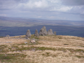
Nine Standards and northeasterly views
SWC Walk 416 - Nine Standards (Kirkby Stephen Circular or to Garsdale)
Aug-23 • thomasgrabow on Flickr
swcwalks swcwalk416 banner 53148648331

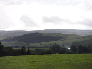
High Dukerdale, from Rigg Beck crossing
SWC Walk 416 - Nine Standards (Kirkby Stephen Circular or to Garsdale)
Aug-23 • thomasgrabow on Flickr
swcwalks swcwalk416 banner 53148648901
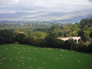
View across Podgill Viaduct to the North Pennines
SWC Walk 416 - Nine Standards (Kirkby Stephen Circular or to Garsdale)
Aug-23 • thomasgrabow on Flickr
swcwalks swcwalk416 walkicon 53149079620

Dukerdale, seen from the Reigill area on the ascent up Hartley Fell
SWC Walk 416 - Nine Standards (Kirkby Stephen Circular or to Garsdale)
Aug-23 • thomasgrabow on Flickr
swcwalks swcwalk416 walkicon 53149143088
Nine Standards, from field near start of walk
SWC Walk 416 - Nine Standards (Kirkby Stephen Circular or to Garsdale)
Aug-23 • thomasgrabow on Flickr
swcwalks swcwalk416 53149141393
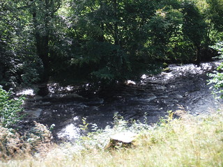
Rushing water on River Eden near start of walk
SWC Walk 416 - Nine Standards (Kirkby Stephen Circular or to Garsdale)
Aug-23 • thomasgrabow on Flickr
swcwalks swcwalk416 53148645546

Rushing water on River Eden near start of walk (close-up)
SWC Walk 416 - Nine Standards (Kirkby Stephen Circular or to Garsdale)
Aug-23 • thomasgrabow on Flickr
swcwalks swcwalk416 53149141423
| Length |
18.1 km (11.2 mi) or 29.3 km (18.2 mi), with 584m or 899/819m ascent/descent. For a shorter or longer walk, see below Walk Options. |
|---|---|
| Toughness |
6 out of 10 or 9 out of 10, with 5 or 8 hours walking time. |
| Walk Notes |
This is relatively short excursion up to a magnificent viewpoint at the top of Hartley Fell, overlooking the North Pennines and the Upper Eden Valley, also with views across to the Howgill Fells and the Lake District, despite only reaching the modest height of 660m above sea level. The top is graced by nine enigmatic differently shaped cairns up to four metres high, the Nine Standards. They are at least 500 years old and believed to be markers of the historic boundary between Westmorland and the North Riding of Yorkshire.
An Alternative Descent leads through Kirkby Stephen town, cutting out Dukerdale and Nateby Common.
|
| Walk Options |
An Alternative Descent off Hartley Fell part-reverses the ascent route and follows lanes and paths into Kirkby Stephen for its tea options: 20.1 km/12.5 mi with 611m ascent/descent, 6/10 rating.
|
| Maps |
OS Landranger: 91 (Appleby-in-Westmorland) & 98 (Wensleydale & Upper Wharfedale)
|
| Travel |
Kirkby Stephen Station, map reference NY 762 066, is 360 km northwest of Charing Cross, 60 km southeast of Carlisle and 263m above sea level. Garsdale Station, map reference SD 788 918, is 15 km south southeast of Kirkby Stephen Station and 343m above sea level. Both are in Cumbria and on the Leeds - Settle – Carlisle Line, with eight trains per day Mon-Sat and seven on Sundays (six at Garsdale). Journey time to Kirkby Stephen is 55 minutes from Carlisle, 44 from Settle and 106 from Leeds. Garsdale is 12 minutes further from Carlisle. Saturday Walkers’ Club: The walk is not practicable as a daywalk from London. |
| Lunch |
Picnic |
| Tea |
Kirkby Stephen Ending
Garsdale Ending
|
| Northern Glossary |
beck: stream, brook; brig(g): bridge; -by: habitation; cam: bank, slope, ridge; carr: marshy woodland or shrubland; clough: narrow valley, cleft in a hillside, ravine, glen, gorge, cliff, rocky precipice; crag: steep rugged mass of rock projecting upward or outward; currick: cairn, pile of stones, often locations used to keep watch for Scottish raiders; dale: valley; -ey: island, dry area in a marshy place; fell: hill, mountain slope (especially rough moorland); firth/frith: long, narrow inlet of the sea or estuary; force/foss: waterfall, rapids; frith: area of peace, protection, safety, security; garth: small grass enclosure adjacent to a house; gate: way, street; gill/ghyll: small narrow valley or ravine; hagg: part of an area of woodland, especially on a sloping bank; holm(e): island, inland promontory, raised ground in marsh, river-meadow; how(e): barrow, small hill; hush: (Roman era) mine on steep hillside, using dammed up water to wash away topsoil and boulders, revealing the underlying lead or ore veins; ing(s): meadow(s), especially water meadow near a river; keld/kell: spring or well; kirk: church; laithe/leeath: barn, agricultural building; lang: long; ling: heather; lonning/lonnin’: lane or track, something less than a road, more rural than a street, usually short; mell: sand dunes; mire: bog; moss: bog, marsh; ness: headland, promontory; nick: shallow notch, cut or indentation on an edge or a surface; pike: spike, sharp point, peak; rake: slant, incline; rigg: ridge; scar/scaur: cliff, rocky outcrop with a steep face; seat/set(t)/side: summer pasture or dwelling place; seaves: rushes; shaw: hurdle, gate; sike/syke/sitch: small stream or gulley, gutter; stang: pole, shaft, stake, wooden bar; stoop/stowp/stoup: post, gatepost, distance marker (milestone), standing stone; -sty: ascent, ascending lane or path, narrow pathway or course; tarn: lake or pond (especially in an upland location); thorp(e)/t(h)rop: village or small settlement; thwait(e): village or small settlement; toft(s): small farmstead with enclosed land, later applied to a village or small settlement; wath: ford; whinny: gorse, furze, thorny vegetation; -wich/wick: village or settlement. |
| Profile | |
|---|---|
| Help Us! |
After the walk, please leave a comment, it really helps. Thanks! You can also upload photos to the SWC Group on Flickr (upload your photos) and videos to Youtube. This walk's tags are: |
| By Train |
Out (not a train station) Back (not a train station) |
| By Car |
Start CA17 4LE Map Directions |
| Amazon | |
| Help |
National Rail: 03457 48 49 50 • Traveline (bus times): 0871 200 22 33 (12p/min) • TFL (London) : 0343 222 1234 |
| Version |
Apr-24 Thomas G |
| Copyright | © Saturday Walkers Club. All Rights Reserved. No commercial use. No copying. No derivatives. Free with attribution for one time non-commercial use only. www.walkingclub.org.uk/site/license.shtml |

Walk Directions
Full directions for this walk are in a PDF file (link above) which you can print, or download on to a Kindle, tablet, or smartphone.
This is just the introduction. This walk's detailed directions are in a PDF available from wwww.walkingclub.org.uk