South Dorset Ridgeway: Osmington or Dorchester to Abbotsbury walk
Long ridge walk with stunning views over Purbeck, the Isle of Portland, Chesil beach and Lyme bay. Travel by bus.
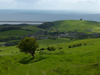
Looking back to Abbotsbury
May-15 • Saturdaywalker on Flickr
book3 walkicon swcwalks walk119 18047566375

Portland from the South Dorset Ridgeway
May-15 • Saturdaywalker on Flickr
book3 walkicon swcwalks walk119 18021086636


View front the South Dorset Ridgeway
May-15 • Saturdaywalker on Flickr
book3 swcwalks walk119 18044263902

The Hardy Monument
Not to the writer, but to Admiral Hardy, the one with Nelson when he died
May-15 • Saturdaywalker on Flickr
book3 swcwalks walk119 17859887580
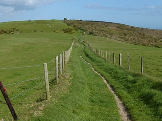
South Dorset Ridgeway
Just east of the Hardy Monument
May-15 • Saturdaywalker on Flickr
book3 swcwalks walk119 17427031073
| Length |
Osmington to Abbotsbury: 21 km / 13 miles with 1450 feet / 450 m of ascent Dorchester to Abbotsbury : about 16km / 10 miles Optional but recommended 2km visit to St Catherine's Chapel at the end, or 5km to Chesil Beach as well |
|---|---|
| OS Maps | OS Explorer 15 (Purbek and South Dorset) |
| Toughness | 6 out of 10 (mainly the length) |
| Walk Notes |
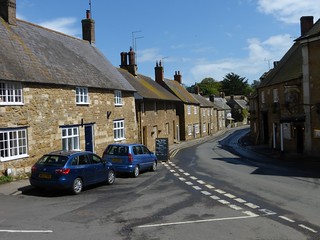
The South Dorset Ridgeway (SDR) in a ridge walk along a treeless lines of hills with stunning views of the Dorset Coast, the Isle of Portland, Lyme Bay, and Chesil Beach (a long spit with a lagoon behind it). The walk starts in the small village of Osmington, and finishes in historic, and very pretty Abbotsbury, which has a Sub-Tropical Gardens (well worth a visit), a Swannery, St Catherine's Chapel (picturesque, on a hill overlooking the town and the bay), Chesil Beach, and a nice pub to wait for your bus in. The SDR is the new name for what used to be a "short cut" section of the South West Coast Path (which has now been diverted to follow the coast, to include the Isle of Portland). The paths are good, the route is easy to follow and well waymarked. Half way along is a short, well signposted, diversion to use a new pedestrian bridge over the A34 (which wont be on older OS maps) A little further, there are views inland (north) to Maiden Castle, an ancient monument. The next landmark is the Hardy Monument NT (Hardy as in 'Kiss me Hardy' of Nelson fame, not 'Thomas Hardy' the writer) at a nice viewpoint near the summit of Black Down (780 ft, 242m). The monument, a tower is closed as of 2014, as the NT don't own the adjacent car-park! The Isle of White, and Devon can bee seen from top (850 ft) - 90km away. Once you reach the coast above Abbotsbury, there are several interesting options - continue along the ridge above the coast, or head down in the town to the Tropical Gardens, the start of Chesil beach, and St Catherine's chapel. Note. The path at Corton Hill has been repaired. There is a new bridge over the dual carriageway in the middle of the walk which may not be shown on older OS maps. |
| Walk Options |
Dorchester to AbbotsburyIf coming from London, start from Dorchester station, walk to the ridge passing Maiden Castle, an impressive Iron Age hill fort (English Heritage, free), walk the best bit to Abbotsbury, visit St Catherine's and the beach, then catch the X53 bus to Weymouth for the train home St Catherine's Chapel and Chesil BeachAt the end of the walk, there is an optional 2km loop to visit St Catherine's Chapel (highly recommended), or 5km round trip if you continue to Chesil Beach (the north end of the spit, always open, recommended) for a swim. Continue north west along the RidgewayInstead of dropping down off the ridge to Abbotsbury, you can continue north west along the ridge (above the coast, marked as a SWCP alternative on OS maps) - a stunning walk. A bit close to the road in places, but still stunning views of Lyme bay. The X53 bus runs along the road, so transport is easy. Travel by TrainTrain travellers can travel to Weymouth. Catch the X53 to Osmington, walk to Abbotsbury, and then catch the X53 bus back to Weymouth You could also split the walk into 2 halves by starting from Dorchester or Upwey stations. Walk to the ridge to join the walk near its mid-point, continue on to Abbotsbury, then catch the X53 bus via Weymouth to Osmington, and do the 1st half of the walk back to the mid-point from there. Chesil BeachDon't even think of walking along the 14 mile (23 km) spit at Chesil Beach. Why? It a nightmare of shingle walking over 180,000,000,000 pebbles. It hard going over the shingle, and once you start, there's no way to cut it short. Most of the spit is closed from April to August inclusive due to nesting birds (from the "Dragon's Teeth" anti-tank block at the north west end of Fleet Lagoon) and there are also closures due to an army firing range (at the south east end of the Lagoon). The Isle of Portland causeway section is always open. If you do decide to walk, check in with the reserve warden's (more so you can help them - they are interesting in nature sightings, and any problems you encounter as bits of the reserve are rarely visited, which is a hint in itself) |
| Transport |
Trains go from London Waterloo and take about 3 hours. Consider Advance fares, or occasional SWT Promotions, e.g. £15 day trips in summer 2014. X53 Bus : Abbotsbury - Weymouth (station) - Osmington The start and finish of the walk are linked (via Weymouth Station) by the regular direct year round "CoastlinX53" bus service (not Winter Sundays between Weymouth at Osmington, £6.50 day ticket, Abbotsbury to Weymouth: £3.50). Check the times before travelling. Sometimes its 2 hourly!. In theory, you could get a Dorchester or Wemouth 'plusbus' train ticket (about £2 return extra), and get a local Weymouth - Upwey - (the ridge) - Dorchester bus to somewhere near the ridge around the center of the walk. |
| Eat |
No refreshments at all during the walk without at least a 1km detour each way on an already long walk. Abbotsbury at the end has 2 nice pubs - The Swan, and the Ilchester Arms. |
| Links |
|
| Profile | |
|---|---|
| Help Us! |
After the walk, please leave a comment, it really helps. Thanks! You can also upload photos to the SWC Group on Flickr (upload your photos) and videos to Youtube. This walk's tags are: |
| By Car |
Start Osmington, Dorset Map Directions Finish Abbotsbury, Dorset Map Directions |
| Map Walk | This walk requires an OS map and a compass or GPS for navigation. You can print out OS maps using the link above. |
| Amazon | |
| Help |
National Rail: 03457 48 49 50 • Traveline (bus times): 0871 200 22 33 (12p/min) • TFL (London) : 0343 222 1234 |
| Version |
Apr-17 Andrew |
| Copyright | © Saturday Walkers Club. All Rights Reserved. No commercial use. No copying. No derivatives. Free with attribution for one time non-commercial use only. www.walkingclub.org.uk/site/license.shtml |


